Abstract
Xinjiang serves as a hub for trans-Eurasian exchange. The Xinjiang hominids are supposed to be greatly influenced by the environment due to the fragile ecology and arid climate. As the territory with the most significant and complex geomorphic units in Inner Asia, Xinjiang features a diverse spectrum of geomorphic forms, including mountains, basins, deserts, river valleys, and oases. This paper presents a systematic summary of the geomorphic locations of 127 Bronze Age to early Iron Age (3000–200 BC) sites and cemeteries in Xinjiang and their economic strategies, exploring the different economic choices of ancient humans who lived in other geomorphic units, and how they adapted to their microenvironments. We have divided Xinjiang into five regions: the Junggar Basin, the Tarim Basin, the Western Tianshan Mountains, the middle Tianshan Mountains, and the Eastern Tianshan Mountains. Our study shows that there were different agropastoral economic modes in different geographical units. Roughly bounded by the Tianshan Mountains, the economy in northern Xinjiang was heavily based on animal husbandry, while oasis farming was popular in the Southern Xinjiang reigon. From the perspective of geomorphology, most sites are situated in mountain valleys, alluvial fans, and oases regions with surface water sources and fine-textured soil cover. Sites near mountains were more likely to develop a mixed pastoral-hunting economy, and oasis communities of a specific size were more likely to build a mixed agricultural-pastoral economy. In large river valleys or alluvial fans, it is expected that settlement clusters and large central settlements will grow, leading to the emergence of social complexity. This study will help to understand the complex “man-land” dynamics between 3000 and 200 BC in Xinjiang.
1 Introduction
Recent years have witnessed an increase in the acknowledgement of the geographical diversity of the Eurasian steppe’s prehistoric economies due to the proliferation of archaeological evidence (Chang, 2002; Frachetti, 2008; Haruda, 2018). Since Frachetti developed the notion of the “Inner Asian Mountain Corridor (IAMC)” (Frachetti, 2008), many scholars have examined the people, cultural exchanges, landscapes, and diversified economies of this region (Frachetti, 2009; Frachetti, 2012; Wang W. et al., 2020). The accumulation of fresh archaeological and Phyto-archaeological data has enhanced scientists’ comprehension of the human lifestyles in this region (Dodson et al., 2013; Doumani et al., 2015; Spengler et al., 2016). Recent research by Spengler et al. (2021) demonstrates the existence of a complex agropastoral economy in Eastern Central Asia between 2000 and 1000 BC, based on nine complementary lines of evidence.
In the IAMC regions, ecology and landscape have long been considered essential to the economy and lifestyle. Frachetti et al. (2017) characterized the entire alpine region of Central Asia as a mobile ecosystem. Li (2020) investigated how ancient Xinjiang farmers adapted to the region’s extreme aridity. Important archaeological sites in Central Asia, such as Begash (Frachetti et al., 2010), Tasbas (Spengler et al., 2014), and Sarazm (Spengler and Willcox, 2013), have provided cases of the adaptability of humans to their landscape. In eastern Central Asia, archaeological sites are dispersed across a landscape characterized by mountains, river basins and lakes, alluvial fans, desert oases, and immense steppes. Ancient communities had multiple opportunities to make economic decisions about the farming, herding, and foraging in each region and ecosystem. To fully comprehend the IAMC region’s complex mixed agropastoral economy system, extensive research on the relationship between landform position and economic pattern is required.
In the third millennium BC, Xinjiang began to play a pivotal role in Inner Asia. Studies into Xinjiang’s prehistoric cultures have made significant strides over the past decades. A preliminary chronology of prehistoric cultures in Xinjiang has been compiled by Han (2007), Guo (2012), and Shao (2018). Wang and Xi proposed that certain nomads may not have lived a nomadic lifestyle and may have established permanent communities based on their fieldwork at the eastern Tianshan Mountains (Wang and Xi, 2009). The ethnographic research of the Adonqolu and Husta Sites showed that seasonal transhumance had existed in the western Tianshan Mountains throughout the early Bronze Age (Jia, 2018). Studies of the Subeixi population (Shevchenko et al., 2014), the Chawuhu population (An and Yuan, 1998; Zhang et al., 2005), and the Tianshanbeilu population (Zhang et al., 2010) revealed the economic strategies in oasis basins. Li (2020) and Dong (2021) respectively summarized the results of archaeobotanical and zooarchaeological studies of Xinjiang, demonstrating the complex mixed agropastoral economy from the Bronze Age to the early Iron Age.
Xinjiang has a dry climate influenced by westerlies, and its ecological environment is fragile and sensitive to climate change. Therefore, the environment significantly affected ancient humans’ lifestyles and economies. Chen et al. (2008) found that the climate was arid during the early Holocene, but it became more humid in the middle and late Holocene (6–1.5 cal ka BP), as evidenced by the high lake surface. This result is supported by a later review based on sporopollen data (Wang and Feng, 2013). The loess-paleosol records also showed that since 6 ka BP, the climate had a trend toward humidity; four paleosol layers were developed, the thickest of which developed in the late Holocene (Chen et al., 2016). The eleven lakes’ aridity and temperature index curves show a spatial variation of the Holocene climate in Xinjiang. It is suggested that the climate became cooler and wetter in the northern Xinjiang region; however, the western Tianshan Mountains region has shown a dry and cold trend (Feng, 2017). Scholars have recently investigated the spatial and temporal processes of changing human subsistence patterns in Xinjiang (Dong G. H. et al., 2022) and the environmental factors forming the agropastoral economy (An et al., 2020). Although significant progress has been made to understand the mixed pastoral-hunting economy in Xinjiang, the discussion between environmental and economic patterns is still limited to macroscopic perspectives of climatic context and geospatial distribution, while in-depth examinations of the landforms and microenvironments that heavily influenced the economic choices are still lacking.
As the region with the most complex geomorphic units in Inner Asia, Xinjiang contains complex landforms such as mountains, basins, deserts, river valleys, and oases, but also a unique landform pattern of “three mountains sandwiched by two basins.” This study examines the landforms and mixed agropastoral economy in Xinjiang and analyzes the economic patterns of ancient humans inhabiting distinct geomorphic units and their adaptations to the environment.
2 Study areas
The Xinjiang Province is located on the southeast edge of the Eurasian steppe, serving as a link for trans-Eurasian trade. The main geologic units in Xinjiang are the relatively stable Tarim and Junggar platforms and the highly active geosynclinal zone around them, which is, the Altai, Tianshan, Kunlun, and Karakoram Mountains (Xinjiang Comprehensive Expedition Team et al., 1978). There are 45 major mountain systems in the Altai, Tianshan, and Kunlun Mountains, which account for 53.64% of the total area (Yang, 2011). Basins or valleys are distributed among the continuous mountains, and oases of different sizes are located in the foothills where the mountains and basins meet, forming a combination of alpine, oasis, basin, and the Gobi Desert. In Xinjiang, the areas of aeolian landform account for 52.17%, and the flowing landform only accounts for 27.07% (Yang, 2011). The desert area is large; however, the quality lands are insufficient.
As part of the arid area of Inner Asia, Xinjiang is far from the sea, forming a temperate continental climate. The temperature in Xinjiang ranges from 20°C to 27°C in the summer and from −10°C to −22°C in the winter. The average annual precipitation is less than 200 mm, affected by geomorphology, altitude, and whether it is on a windward slope (Yang, 2011). The water sources are different in various geomorphic locations: the mountain valley is fed by precipitation; the oasis is supplied by mountain water; and the desert basin is supplied by surface rivers and underground water (An et al., 2020).
The vertical vegetational zonation of the Tianshan Mountains is remarkable. On the Northern slope, there is alpine and subalpine meadow between 2,900 and 3,600 m asl, forming good summer pasture; between 2,200 and 2,900 m asl is the mountainous coniferous forest; between 1,800 and 2,200 m asl is the middle-temperate mountain steppe, suitable for pasture and crop growth; and from 1,500 to 1,800 m asl, the Gobi Desert forest is widely distributed with various desert trees and shrubs. On the Southern slope, between 2,500 and 3,800 m asl is the alpine sub-alpine mountain steppe; between 2,200 and 2,500 m asl is the mountain grassland; from 1,700 to 2,200 m asl is the weathered rock desert; between 1,000 and 1,700 m asl is the Gobi Desert forest; and from 500 to 1,000 m asl is the oasis.
Recent archaeological discoveries show that both Western (wheat) and eastern (millet) crops were present in the Junggar region as early as 3000 BC (Zhao, 2009; Zhou et al., 2020). During the Bronze Age, the spread of the Seima-Turbino and the Andronovo cultures significantly impacted neighboring regions. The Andronovo culture mainly influenced the western region of Xinjiang (Chan and Shao, 2018). Seima-Turbino cultural remains are found in the northern Junggar Basin, northern Tianshan Mountains, and the eastern Tarim Basin, etc., (Lin, 2016). By the late Bronze Age, East-West interactions had intensified (Han, 2021). The early Iron Age was a mature time of East-West exchange, with increasingly close regional connections between cultures within the Xinjiang region from the mid-1000 BC onward (Shao, 2009).
3 Material and methods
We systematically studied the geomorphic location and economic strategies of the archaeological sites and cemeteries from the Bronze Age to the early Iron Age (3000-200 BC) in Xinjiang. There are two criteria: 1) All the sites have been systematically excavated or investigated, and the archaeological reports have been published; 2) Reliable dates have been obtained from radiocarbon dating or typology analysis. A total of 127 sites (including 91 cemeteries) were selected for analysis, of which 79 sites (including 45 cemeteries) had AMS 14C dates (Figure 1).
FIGURE 1
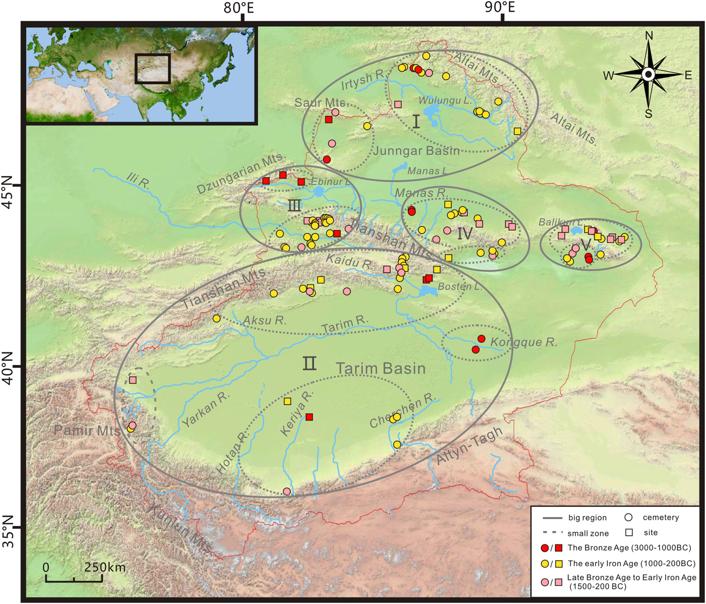
Map of Xinjiang, with the sites and the subregions of this study. I. Junggar Basin; II. Tarim Basin; III. Western Tianshan Mountains; IV. Middle Tianshan Mountains; V. Eastern Tianshan Mountains.
Due to the vast area and numerous remains in Xinjiang, it is difficult to conduct field investigations of each site and cemetery. Therefore, we used the geographic coordinates to locate most sites (66 sites). For the sites whose coordinates were not published, we located them according to the map and description of the location from the archaeological report (61 sites). We use the Baidu topographic map to identify the geomorphic location of each site. Besides, we conducted three field investigations in the Bortala River Valley, Ili River Valley, and Kashi region, respectively, in the years 2018, 2020, and 2021, and investigated the landform positions of the Quanshuigou, Jirentaigoukou, Adonqolu, Husta, and Wupaer Sites.
Spengler et al. (2021) put forward nine categories of evidence to study the mixed agropastoral economies in Central Asia. This study considered all the evidence as thoroughly as possible, including: archaeological excavated materials, plant remains (large fossils and microfossils such as phytoliths, starch grains, and sporopollens), zooarchaeological evidence (animal bones and isotope data). We classify the bones of cattle, sheep, and horses, fur and dairy products, and horse harness as the evidence of pastoralism practices; while the crop remains, the tools of the sickle, pestle, millstone, spinning wheel, grinding rod are classified as evidence of farming or gathering activities; the arrowheads, bows, and fish hooks are considered to be hunting or fishing tools. However, as food exchanges might have frequently happened between “farmers” and “herders” (Dong et al., 2022a), the unearthed plant remains can not be used as conclusive evidence of farming activities, as they might have been exchanged with other agricultural populations.
Carbon and Nitrogen isotope data provide an important index for studying the diets of people. The δ15N values of carnivores that feed on herbivores and fish range from 9‰ to 12‰, among which the δ15N values of herbivores are about 3‰–7‰, the δ15N values of first-level carnivores and fish are generally higher than 10‰; the δ15N values of omnivores range from 7‰ to 9‰ (Cong et al., 2021). The mean Corbon isotope values of C3 plants is reported to be around −26.5‰ with a range of −35‰ to −20‰; C4 plants is reported to be around −12.5‰ with a range of −16‰ to −7‰ (Marino and McElroy, 1991). However, the isotope data should be carefully analyzed. For example, high δ15N values may be related to dairy diets. There is a dietary habit even among modern farmers in Xinjiang. As a result, a high δ15N value does not definitely indicate a meat-based diet, nor does it indicate a herding-based economy. Besides, the δ15N value is affected by the enrichment law of trophic level, environment, and animal situation (Hedges and Reynard, 2007; Chen, 2017). As the δ15N value is generally higher in arid environments, the high δ15N value at most sites in Xinjiang cannot rule out by the possibility that they are affected by the drought climate (Hartman, 2011). Similarly, due to the concentration of carbon isotopes in herbivorous livestock, the content of δ13C in the bones of the man who ingested cattle and sheep will also be raised. As a result, using 13C to determine whether humans consume C3 or C4 plants should be done with caution.
In this paper, the Bronze Age (BA) ranges from 3000–1000 BC, and the early Iron Age (EIA) ranges from 1000–200 BC (Shao, 2018). All the dates are calibrated in BC. We divide Xinjiang into five regions according to the geographical zones: the Junggar Basin, Tarim Basin, Western Tianshan Mountains, middle Tianshan Mountains, and Eastern Tianshan Mountains. Each region is segmented into several smaller zones, according to the geographical zones and Shao’s archaeological culture partition (Shao, 2018) (Figure 1).
It should be noted that our study is built on two assumptions: 1) The cemeteries are close to the sites where people have lived (Cong et al., 2013; Jiang et al., 2013; Xinjiang Institute of Cultural Relics and Archaeology, 2016a). Archaeological excavations have shown that the sites and tombs are usually close to each other in most cases in Xinjiang (Liu and Guan, 2002; Jiang et al., 2014; Yu et al., 2016). Although special cases may exist, we presume they are not common and will not influence the results. 2) Replace ancient landforms with modern landforms. Geomorphologic evolution has been known to happen over millennia. However, our field investigations have shown that the landforms in Xinjiang did not change much due to the lack of thick sediments and strong transporting forces, especially during the late Holocene (Zhang Y. P. et al., 2021; Zhang et al., 2022). Moreover, we will pay special attention to the sites with geomorphic changes in our discussion.
4 Results
4.1 Junggar Basin
4.1.1 Northern margin area of Junggar Basin
This region consists primarily of the Altai piedmont plain, Ulungur Lake, and Junggar’s western piedmont plain. In front of the Altai Mountains, sloping alluvial plains are formed by the Kelan River, Burqin River, Haba River, and some other short seasonal rivers. These plains are made up of alluvial fans and terraces with sand and gravel sediments. The southern bank of the Irtysh River is mainly composed of Neogene and early Quaternary sandstone, which is covered by sand dunes. There are seventeen sites, including fifteen cemeteries, in this area (Figure 2A).
FIGURE 2
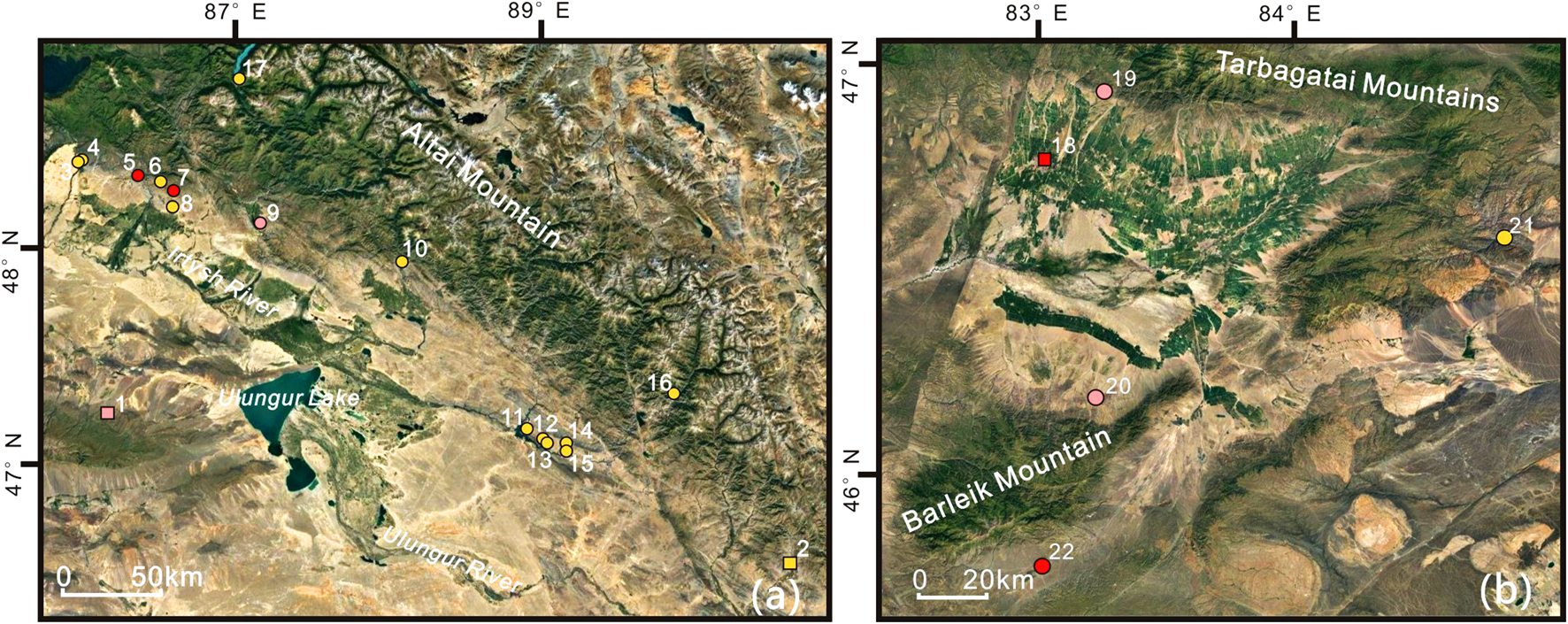
Topographic map of Junggar Basin and the sites mentioned in this study. (A) Northern margin area of Junggar Basin. 1. Tongtian Cave; 2. Huahaizi No.3; 3. Jialanggashi; 4. Habahan; 5. Ayituohan No.1;6. Dongtalede; 7. Tuoganbai No. 2; 8. Kalasu; 9. Shankoushuidian in Burqin County; 10. Wulasite; 11. Taledesayi; 12. Qilikete; 13. Sawudiegeer; 14. Sukeerte; 15. Saerbulake; 16. Zhelegabashi; 17. Tuwaxincun. (B) Western margin area of Junggar Basin 18. Xiakalangguer; 19. Abudulashuiku; 20. Aletengyemuleshuiku; 21. Baiyanghe; 22. Sazicun.
4.1.1.1 Altai mountain valleys and alpine lakes
There are four sites (Figures 2A, 2.10.16.17), including three cemeteries on the terraces or oases around the mountain valleys and alpine lakes of Altai Mountain. The excavated stiff-bits, iron knives, arrowheads, and arrows suggest a pastoral economy and hunting activities (Figures 2A, 10.16.17) (Xinjiang Institute of Cultural Relics and Archaeology, 2013a; 2015a; Yu et al., 2014a). The δ15N (10.2‰ and 10.8‰) and δ13C (−18.7‰ and −17.8‰) values of two human bones from Tuwaxincun Cemetery (Figures 2A, 17) show that the resident consumed a large number of animal proteins but hardly any C4 crops (Dong et al., 2022b). Deer stones, stone circles, and stone cairns were discovered at Huahaizi No. 3 Site in Sandaohaizi (900–500 BC; Figures 2A, 2), which is speculated as the ceremonial and sacrificial center of early nomadic society (Guo et al., 2016).
4.1.1.2 Planation surfaces in the South of altai mountain or platforms on both sides of the North-South river
The tributaries of the Irtysh River flow from the Altai Mountains’ southern foothills. This area is near the mountains, with abundant grassland and water.
There are seven cemeteries (Figures 2A, 3–9) on the planation surfaces. Isotopic analysis of two BA cemeteries (Figures 2A, 5.7) shows the inhabitants relied heavily on animal protein (Yu et al., 2014b; Dong et al., 2022b). However, the strong C4 signatures at Ayituohan No. 1 Cemetery (2836–2490 BC) indicate that the inhabitants probably consumed the millet (Qu et al., 2020). One cemetery of mid-late BA to EIA (Figures 2A, 9) discovered iron knives, stiff-bits, and the burying horse, showing a nomadic economy. Human bones from Kalasu (EIA) with δ15N values ranging from 10.9‰ to 12.6‰ and δ13C values ranging from −17.2‰ to −16.1‰ indicate that inhabitants relied heavily on meat- or -dairy - based diets (Chen et al., 2017). This evidence shows a mainly pastoral economy.
Five EIA cemeteries (Figures 2A, 11.12.13.14.15) lie on the platform along the river. Stirrups, stiff-bits, copper fish hooks, and arrowheads identified at these cemeteries indicate a mixed pastoral -hunting economy.
The Tongtian Cave, a rock shelter site in the deep valley of the low hills north of Saur Mountain, dates from the Paleolithic to the Bronze Age (Figures 2A, 1). In the BA layer (3250–1250 BC), plant macrofossils of wheat, barley, foxtail millet (Setaria italica), and broomcorn millet (Panicum miliaceum) were identified, providing evidence of crop planting (Zhou et al., 2020). The pikas, voles, and small bird remains were unearthed, indicating hunting activities (Zhou et al., 2020).
4.1.2 Western margin area of Junggar Basin
The western margin of the Junggar Basin is mostly located in Xinjiang’s northwest corner. The main geomorphic unit is the Tacheng-Tuoli alluvial plain. There is a high-coverage semi-desert steppe inside the flat plain of the Tuoli Basin, and the sediments are made up of sand and fine soil. The low-lying, flat floodplain in the abdomen of Tacheng Basin is inset with many meandering streams and swamps, where thermophilic plants such as Phragmites australis and Splendens are flourishing. The margin area of the basin is the alluvial plain, composed of gravel and loess-like soil, showing a desert environment with sparse vegetation. There are five sites, including four cemeteries, in this area (Figure 2B).
4.1.2.1 Mountain valleys
The Baiyanghe Cemetery of EIA (Figures 2B, 21) is located in the Baiyang River Valley. Bronze and iron swords, bows, arrowheads, and millstones were excavated, indicating herding and hunting activities (Wang and Tian, 2012).
4.1.2.2 On the alluvial fans
The gully on the alluvial fan in this area is well developed. On the top of the fan, small oases are often developed between the edges of the fans. Two cemeteries of mid-late BA to EIA (Figures 2B, 19.20) excavated relics of sheep and horse bones, arrowheads, iron swords, and bone buckles (Xinjiang Institute of Cultural Relics and Archaeology, 2016b; Wu et al., 2017).
4.1.2.3 Alluvial fan margin oases
One site (1450–1300 BC; Figures 2B, 18) lies in the oasis at the front of the alluvial fan in the south of Taerbahatai Mountain (Yuan et al., 2017). Charcoal, pottery pieces, and broken bones of cattle, horses, and sheep were unearthed in the kiln’s layer. Wheat was identified, too (Dodson et al., 2013).
4.2 Tarim Basin
4.2.1 Northern margin area of Tarim Basin
On the North margin of is the flood-alluvial-lacustrine plain is located on the Tarim Basin’s northern margin. The main rivers originate from the Tianshan Mountains’ Southern slope, such as the Kongque River, Kuche River, Weigan River, and Aksu River. They carry the sediments to the foothills, forming alluvial fans. The alluvial plains are composed of fluviological deposits and debris flows, forming some large delta plains and oases that have become important agricultural districts of southern Xinjiang. There are 22 sites, including fifteen cemeteries, in this area (mainly EIA remains) (Figure 3A).
FIGURE 3
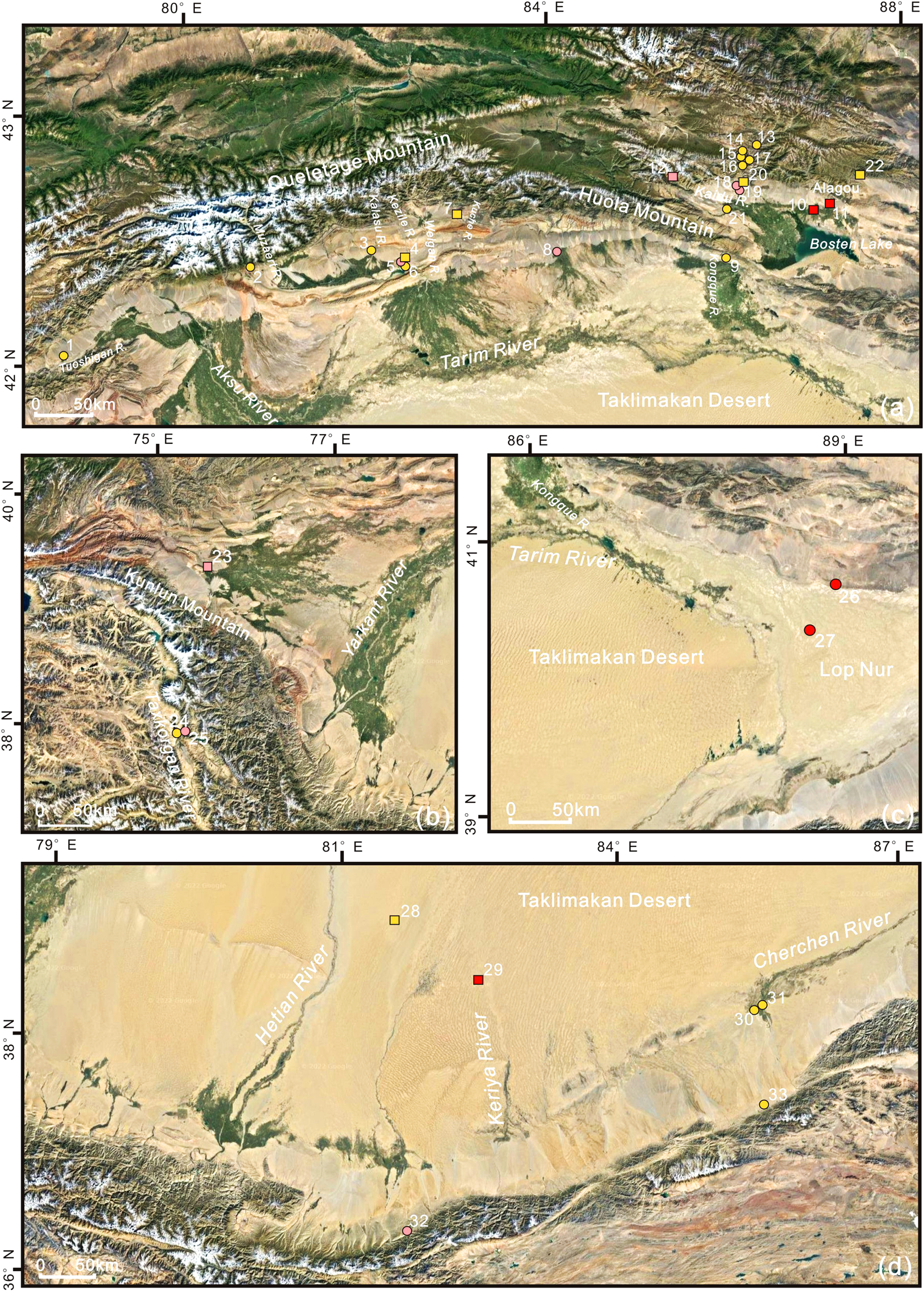
Topographic map of Tarim Basin and the sites mentioned in this study. (A) Northern margin area of Tarim Basin. 1. Kulansarike; 2. Baozidong M41; 3. Duogang; 4. Kezier; 5. Keziertuershuiku; 6. Karigayi; 7. Tikemaike; 8. Qunbake; 9. Shanghuxiang; 10. Xintala; 11. Quhui; 12. Mohuchahan; 13. Habuqihan I and II; 14. Narenhabuqihangou; 15. Daxigou No.1; 16. Qiaoenqiakeledeke; 17. Daxigou No.4; 18. Chawuhu No.4; 19. Chawuhu No.1; 20. Hejingzhonggongyeyuanqu; 21. Baileqier; 22. Hongshangou. (B) Southwestern margin area of Tarim Basin. 23. Wupaer; 24. Jierzankale; 25. Xiabandi. (C) Eastern margin area of Tarim Basin. 26. Gumugou; 27. Xiaohe. (D) Southern margin area of Tarim Basin. 28. Yuansha Gucheng; 29. Northern Niya; 30. Zhagunluke; 31. Jiawaairike; 32. Liushui; 33. Gudaqi.
4.2.1.1 Mountain valleys
There are seven sites (Figures 3A, 12.13.14.15.16.17.22), including five cemeteries (Figures 3A, 13.14.15.16.17), in the mountain valleys. Mohuchahan (950–850 BC; Figures 3A, 12) is located between the piedmont alluvial fans on the East bank of the Mohuchahan River (Xinjiang Institute of Cultural Relics and Archaeology, 2016a). The mean δ13C values (−18.2‰ ± 0.7‰) and mean δ15N values (12.6‰ ± 0.6‰) of nine human bones, as well as the mean δ13C values (−18.6‰ ± 1.0‰) and mean δ15N values (5.0‰± 2.1‰) of 20 animal bones, indicate the heavily meat-based diet and mainly C3 diets (Dong et al., 2022a). Moreover, the unearthed weapons, life appliances, and horse harnesses without farming tools showed that animal herding is an important way for people to live. The isotope data of a few bones show that C4 plant sources may result from communication with the surrounding oasis population (Dong et al., 2022a). Hongshangou of the EIA (Figures 3A, 22) is located at the small basin at the southern foot of the Tianshan Mountains, where the sacrificial remains, including stone relics, residential remains, and tombs, were unearthed (Hou, 2016). The unearthed copper knives, arrows, and bones of sheep and horses in five cemeteries (Figures 3A, 13.14.15.16.17) suggest a pastoral economy and hunting activity (Xinjiang Institute of Cultural Relics and Archaeology, 2015b).
4.2.1.2 On the alluvial fans
Three EIA sites (Figures 3A, 2.3.20) are in this area. Duogang (900–500 BC; Figures 3A, 3) is located near the oasis of the alluvial fan (Zhang X. L. et al., 2014). The mean δ15N values (12.56‰) and mean δ13C values (−14.77‰) of 39 human bones indicate a meat-based heavy diet and mixed C3 and C4 diets in this cemetery (Zhang X. L. et al., 2014).
4.2.1.3 Alluvial fan margin (river valley) oases
Eleven sites (Figures 3A, 1.4.5.6.7.8.9.10.11.18.19), including seven cemeteries (Figures 3A, 1.5.6.8.9.18.19), are situated in this geomorphic location. Two BA sites (Figures 3A, 10.11) are located at the fan margin oasis area on the north bank of Bosten Lake. The oasis is large and has abundant water. Farming tools and botanical remains (wheat, naked barley, and broomcorn millet) were excavated at Xintala Site (1950–1650 BC; Figures 3A, 10) (Zhao et al., 2013).
Four cemeteries of mid-late BA to EIA (Figures 3A, 5.8.18.19) were discovered. Qunbake (mainly 950–600 BC; Figures 3A, 8) is located in the fan-margin oasis at the southern foot of Huola Mountain. Millstones and plant remains (wheat and broomcorn millet) were found here; horse and sheep bones, leather, iron knives, and arrowheads were also excavated. The evidence points to an agropastoral economy supplemented by hunting activities (Sun and Chen, 1987; Cong and Chen, 1991). The two Chawuhu cemeteries (Figures 3A, 18.19) lie on the first terrace and sloping platform of Chawuhu valley, respectively, in the northwest of the Yanqi Basin. Both of them are near the fan margin oasis. Stiff-bits, horse bounders, and arrowheads were unearthed from Chawuhu No. 1 (Figures 3A, 19) (Xinjiang Institute of Cultural Relics and Archaeology, 1992). Because the number of horse bones accounted for a large proportion, students speculate that horse bones stem from domestic horses (An and Yuan, 1998). Besides, the evidence of residues and physical anthropology analysis suggests that the Chawuhu population at Chawuhu No. 4 (Figures 3A, 18) relied on meat- or dairy-heavy diets and consumed wheat and barley (Zhang et al., 2005).
Five EIA sites (Figures 3A, 1.4.6.9.7), including three cemeteries (Figures 3A, 1.6.9), were discovered in the southern Queletage and Huola Mountains. Tikemaike (Figures 3A, 7) lies on the oasis of the Kuche River. Slag smelting, flow pipes, and pottery pieces were discovered at this site, showing metallurgical elements (Ruan et al., 2016). The unearthed iron arrowheads from Shanghuxiang (Figures 3A, 9) suggest hunting activities (He, 1999).
4.2.2 Southern margin area of Tarim Basin
The topography of this region is high in the South and West and low in the North and East. The main geomorphological unit is the piedmont gravel plain on the north of the Kunlun Mountains and Altun Mountains, which is composed of alluvial fans of different sizes. The sites and cemeteries are distributed along the Hetian River, Keriya River, and Cherchen River from West to East. The Hetian River is the largest river on the Northern slope of the Kunlun Mountains. It flows through the Taklimakan Desert and is supplied by mountain precipitation and glacial meltwater. Big oases and alluvial plains along the Keriya River have a large amount of water. The Cherchen River has a small amount of water and a deeply cut valley. The lower part of the plain is composed of sandy, loamy soil, on which fixed or semi-fixed dunes are distributed. The fine soil plain is supplied by springs and floods, which is favorable for developing agriculture. There are six sites, including four cemeteries, in this area (Figure 3D).
4.2.2.1 On low hills and alluvial fans
In this geomorphic area, there are two cemeteries (Figures 3D, 32.33). Liushui (1108–493 BC; Figures 3D, 32) is located on the lower hills. Combined with paleopathological analysis, stiff-bits, bridle-bits, and arrowheads were unearthed from this cemetery, providing evidence for animal herding and hunting (Zhang X. et al., 2014; Wu et al., 2016). Gudaqi (500–300 BC; Figures 3D, 33) lie on an alluvial fan. Horse and sheep head remains were found in almost all burials here, probably indicating developed animal husbandry (Xinjiang Institute of Cultural Relics and Archaeology, 2013b).
4.2.2.2 Alluvial fan margin oases
Two EIA cemeteries (Figures 3D, 30.31) lie on the alluvial fan margin oasis area along the Cherchen River. Wheaten food, arrowheads, bows, horse and sheep bones, and leather products were excavated at Zhagunluke (1050 BC–500 AD; Figures 3D, 30), indicating an agropastoral economy and hunting activities (Xinjiang Institute of Cultural Relics and Archaeology, 1998a; Wang et al., 2003).
4.2.2.3 River oases in the desert
Two sites (Figures 3D, 28.29) were discovered in the Taklimakan Desert and were presumed to be located in the ancient river oasis. Yuansha Gucheng of EIA (Figures 3D, 28) lies on an oasis near the Keriya River. Wheat, barley, broomcorn millet, and the irrigation system were found (Debaine et al., 2010; Li, 2020); domesticated animals (Capra sp., Ovis sp., Bos taurus, and Camelus bactrianus, etc.) and wild animal remains (Lepus sp., Nesokia indica, and Aves, etc.) were also unearthed here (Huang, 2008). These remains point to the agropastoral economy and hunting activities.
4.3.3 Southwestern margin area of Tarim Basin
The Tarim Basin’s Southwestern margin is located East of the Pamir Plateau. The terrain slopes from Southwest to Northeast, with the Karakorum Mountains in the Southwest, the Yarkant River alluvial plain in the middle, and the Taklimakan Desert in the East. Most of the terrain is relatively flat, and there is a large amount of sand and gravel in the Taxkorgan Valley. Plants grow well in the valley but are rare or scarce on the bilateral slopes. There is a small amount of forest on the windward slope of the Western mountain. Three sites, including two cemeteries, are found in this area (Figure 3B).
4.3.3.1 Mountain valleys
Two cemeteries (Figures 3B, 24.25) lie in the Taxkorgan River Valley on the eastern margin of the Pamir Plateau. The mean δ13C values (−18.2‰ ±0.8‰) and mean δ15N values (12.3‰ ±1.0‰) of 26 human bones at Xiabandi (1500–600 BC; Figures 3B, 25) show heavy meat-based diets mixed with a few C4 diets (Wu, 2005; Zhang et al., 2016).
4.3.3.2 Alluvial fan margin oases
The Wupaer Site of mid-late BA to EIA (1500–400 BC; Figures 3B, 23) lies on the alluvial fan margin oasis of Konggur Mountain. Some farming tools (such as sickles, pestles, millstones, etc.) and plant remain (barley, wheat, millet, and Fabaceae) were identified, indicating an agricultural economy (Yang et al., 2020).
4.3.4 Eastern margin area of Tarim Basin
This region mainly refers to the Lop Nur, including the alluvial plains of the lower reaches of the Kongque River and Tarim River. Most of the landforms are composed of salt crust. Through long-term drying, denudation, and wind erosion, the ancient lake plain was transformed into various landforms such as Yadan, wind erosion depressions, and wind erosion plains (Figure 3C).
River oases in the desert
Xiaohe (Figures 3C, 27) is located in the ancient oasis near the Kongque River in the Lop Nur desert. Paleoenvironment research showed that during Bronze Age, there was a well-developed oasis around the Xiaohe area (Li et al., 2013; Yang et al., 2014). Common millet and wheat were identified, suggesting a farming economy at Xiaohe (1884-1736 BC) (Yang et al., 2014; Zhang F. et al., 2021). Domesticated cattle, dairy products, and arrows unearthed here show a husbandry economy and hunting activities (Zhang Y. F. et al., 2017).
Gumugou (ca. 1850 BC; Figures 3C, 26) is located at the ancient oasis on the north bank of the lower reaches of the Kongquehe River, which is close to the mountain. The δ13C values (ranging from −18.39‰ to −17.85‰) and δ15N values (ranging from 13.58‰ to 15.33‰) of ten human bones suggest that the people relied heavily on animal products and also consumed C3 plant (Zhang and Zhu, 2011; Zhang et al., 2015).
4.3 Western Tianshan Mountains
4.3.1 Bortala River Basin
The terrain of this region slopes from west to east and consists of three large landform units: the Alatau in the North, the Borohoro Mountains in the South, and the Bortala Valley and Ebi Lake Basin in the middle. The high and middle mountains, low hills, plains, and valleys line up in a ladder shape. In the North of Bortala valley, there are huge alluvial fans in front of the Alatau Mountain, the upper sediment is loess, and the lower is gravel. There are four terraces along the North bank of the Bortala River. Three sites were found in this area (Figure 4A).
FIGURE 4
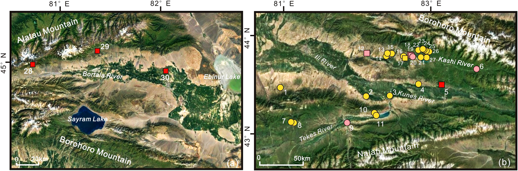
Topographic map of Western Tianshan Mountains and the sites mentioned in this study. (A) Bortala River Basin. 28. Adonqolu; 29. Husta; 30. Quanshuigou. (B) Ili River Basin. 1. Suodunbulake; 2. Fanliuyilegedai; 3. Shankoushuiku in Gongliu County; 4. Tiemulike; 5. Ayousaigoukou; 6. Tangbalesayi; 7. Biesikalagai; 8. Saerhuobu; 9. Koksu West Cemetery No.2; 10. Plot XV and Plot X, Area A, Qiafuqihai; 11. Yeshikelieke site A; 12. Kalasu; 13. Shibukeqi No.1 14. Shibukeqi No.2; 15. Taerketebei; 16. Dongmaili; 17. Qiongkeke; 18. Qialegeer; 19. Jirentaigoukou; 20. Wutulan; 21–26. Jialekesikayinte; 27. Qirentuohai.
4.3.1.1 On the alluvial fans
Adonqolu (1743–1680 BC; Figures 4A, 28) lies on the top of the alluvial fan, where a small oasis emerges at the junction of the two nearby fans (Cong et al., 2013). Husta (1370–1175 BC; Figures 4A, 29) lies on the fans with many gullies; some small oases are exposed near the fan edge (Cong et al., 2018). The phytoliths of wheat, barley, common millet, and foxtail millet were identified at Adonqolu, and the starch grains of millet were identified at Husta, indicating agricultural elements (Cong et al., 2018; Shao et al., 2019). The isotopic analysis of human dental calculus at Adonqolu (mean δ13C values of −19.528‰ ± 0.2‰ and mean δ15N values of 11.6‰ ± 0.2‰) suggests predominantly C3 diets and heavily meat-based diets (Cong et al., 2021). Besides, strontium isotopic analysis of human enamel and bones shows that Adonqolu residents experienced migrations (Cong et al., 2021). Archaeologists speculated that seasonal transhumance probably played a vital role in the inhabitants’ lives at Adonqolu and Husta (Jia, 2018).
4.3.1.2 Alluvial fan margin oases
Quanshuigou (1550–1050 BC; Figures 4A, 30) is located at the alluvial fan margin oasis on the southern foot of Alatau Mountain (Zhang et al., 2022). Unambiguous evidence of the metallurgical site, such as copper slag and ore, was found. The animal remains (cattle and sheep bones) and the production tools (such as bronze sickles) were excavated at the site. It is speculated that the site is a bronze metallurgical settlement with mixed agropastoral economy (Han and Chen, 2017).
4.3.2 Ili River Basin
The alluvial plain of Ili Valley, which consists of the Ili Basin and the Kunes Basin, has an altitude of 540–700 m asl. The riverbed slopes gently, so the floodplain and marshland are well developed. Twenty-seven sites, including twenty-two cemeteries (Figure 4B).
4.3.2.1 Loess platforms on both sides of the river valley
Three sites (Figures 4B, 12.18.19) are located at the loess platform on the north bank of the Kashi River, the first-grade tributary of the upper reaches of the Ili River. In Jirentaigoukou (2631–1020 BC; Figures 4B, 19), charred broomcorn millet seeds were identified (Wang Q. et al., 2020). The isotope analysis suggests a pattern of feeding sheep and cattle and a mixed C3 and C4 diet (Wang et al., 2019).
This area has one BA cemetery (Figures 4B, 9) and seven EIA cemeteries (Figures 4B, 2.3.4.13.14.15.20). Painted pottery, mutton, and iron knives were excavated at Wutulan (Figures 4B, 20), and iron knives and arrowheads were found at Koksu West Cemetery No. 2 (Figures 4B, 9), indicating the mixed husbandry and hunting economy (Ruan et al., 2012; Ruan et al., 2014).
4.3.2.2 River valley oases
Four sites (Figures 4B, 5.10.11.17), including two cemeteries (Figures 4B, 10.11), provide evidence of animal husbandry and hunting. An abundance of horse and sheep bones and saddle-shaped millstones was unearthed at Ayousaigoukou (1410–1260 BC; Figures 4B, 5) on the bank of the Kashi River (Xinjiang Institute of Cultural Relics and Archaeology, 2013c; Wang et al., 2019). The δ13C values (ranging from −16.02‰ to −16.47‰) and δ15N values (ranging from 12.08‰ to 13.33‰) from eight human bones at Qiongkeke (1000–500 BC; Figures 4B, 17) suggest that ancient inhabitants relied on meat-based diets and had a mixed C3 and C4 diet (Liu and Guan, 2002; Zhang and Li, 2006).
4.3.2.3 On the alluvial fans
There are three EIA cemeteries (Figures 4B, 1.7.8) in this area. Combined with excavated iron knives and sheep bones, it is presumed to be an animal husbandry economy at Suodunbulake Cemetery (Xinjiang Institute of Cultural Relics and Archaeology, 1995).
4.3.2.4 Mountain valleys
There are eight cemeteries in the valley. Tangbalesayi (Figures 4B, 6) is located near the mouth of the Tangbalesayi gully. Seven cemeteries (Figures 4B, 21–27) lie in the valley of the Jialekesikayinte mountain. Arrow shafts and quivers were discovered at Qirentuohai (Figures 4B, 27) (Xinjiang Institute of Cultural Relics and Archaeology, 2004). Arrowheads were discovered at the burials (Figures 4B, 21–26), indicating a hunting activity (Xinjiang Institute of Cultural Relics and Archaeology et al., 2007).
4.4 Middle Tianshan Mountains
4.4.1 Areas on both sides of the middle Tianshan Mountains
Anticline hills and valleys were distributed at the Northern foot of the Tianshan Mountains below 1,500 m asl between the city of Wusu and Urumqi. Thick alluvial sand and gravel layers are deposited in the valley from South to North. The hills with rounded tops are cut into canyons, developing multilevel terraces. The alluvial fans of the Manas River have relatively flat terrain. The deposits gradually tapered from the top to the edge of the fan and transitioned from sandy pebbles to fine soil. The groundwater level is high, resulting in swamping and salinization. There are sixteen sites, including eleven cemeteries, in this area (Figure 5A).
FIGURE 5
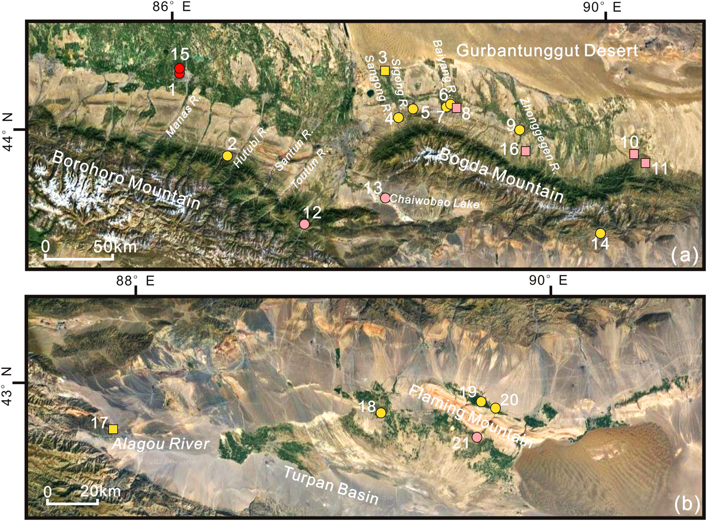
Topographic map of middle Tianshan Mountains and the sites mentioned in this study. (A) Areas on both sides of the middle Tianshan Mountains. 1. Liangzhongchangyilian; 2. Shimenzi; 3. Fukangfubeinongchangjijiandui; 4. Sangongxiang; 5. Choumeigou; 6. Xigou Ⅱ area; 7. Baiyanghe; 8. Xigou Ⅰ area; 9. Dalongkou; 10. Sidaogou; 11. Gangou; 12. Saensayi; 13. Chaiwobao; 14. Ertanggou; 15. Shuinichang; 16. Luanzagangzi. (B) Turpan Basin. 17. Yuergou; 18. Jiayi; 19. Shengjindian; 20. Subeixi; 21. Yanghai.
4.4.1.1 Mountain valleys
There are nine sites (Figures 5A, 2.4.5.6.8.10.11.12.14), including six cemeteries (Figures 5A, 2.4.5.6.12.14) in this area. Wheat and barley were identified in the early BA layers at the Saensayi (2480–530 BC; Figures 5A, 12), suggesting a farming economy (Liu et al., 2021). Large pottery for grain storage, agricultural tools carbonized grain particles, and large animal bones were unearthed at Sidaogou (975–451 BC; Figures 5A, 10), showing an agropastoral economy (Du and Ren, 2017; Tian et al., 2021). Horse and sheep bones, harnesses, and arrows were found at two cemeteries (Figures 5A, 2.14), suggesting a pastoral economy and hunting activity (Xinjiang Institute of Cultural Relics and Archaeology, 2012; Zhang Y. Z. et al., 2014).
Stiff-bits and arrowheads were unearthed at Ertanggou (700–500 BC; Figures 5A, 14), showing hunting activities (Xinjiang Institute of Cultural Relics and Archaeology, 2012). Iron knives, harnesses, and arrowheads were found at Shimenzi (Figures 5A, 2). Paleoanthropological research indicates that the residents relied heavily on animal products and also engaged in hunting (Zhang Y. Z. et al., 2014).
4.4.1.2 On the alluvial fans
There is one site (Figures 5A, 16) and two EIA cemeteries (Figures 5A, 7.9). Broomcorn millet, foxtail millet, and wheat/barley were identified in Figures 5A, 16 (1372–890 BC), indicating a farming economy (Zhang J. P. et al., 2017).
4.4.1.3 Alluvial fan margin oases
One site (Figures 5A, 3) and three cemeteries (Figures 5A, 1.13.15) are located in this area. Chaiwobao (Figures 5A, 13) is near the lake at the lowest part of the basin between two mountains. Large potteries, arrowheads, and horse and sheep bones were excavated here, suggesting an animal husbandry economy supplemented by hunting (Xinjiang Institute of Cultural Relics and Archaeology, 1998b).
4.4.2 Turpan Basin
The Turpan Basin can be divided into three areas: 1) The high basin in the north of Huoyanshan-Yanshan Mountains. Various sizes of channels originating from the South slope of Bogda Mountain carry sediments to accumulate alluvial fans. The sediments are composed of sand, gravel, and pebbles. The fine silt and clay have been eroded by the wind, so there is no vegetation on the fans. However, the fine soil belt at the edge of the fan forms oases where the plant grows well. 2) The mountain systems are across the central of the basin, where bare rocks are exposed to the air, and no vegetation is growing. 3) Low intermountain basins on the South of Huoyanshan and other mountains. Oases developed in the north and west of Aiding Lake. In the South of the lake is the diluvial plain of the Jueluotage Mountains. The sediments are mainly composed of angular gravel, and the vegetation is rare. In the east of Aiding Lake is the Kumtag Desert. The river system from the Tianshan Mountains to the basin formed numerous oases in Turpan Basin. Five cemeteries of Subeixi culture were found in this area (Figure 5B).
4.4.2.1 Alluvial fan margin oases
There are three cemeteries (Figures 5B, 19.20.21) near Huoyanshan Mountain in Turpan Basin and one cemetery (Figures 5B, 18) on the Gobi platform in the south of Turpan Oasis.
Plant remains (such as wheat, millet, and naked barley), harness, leather, and wool clothing were discovered at Yanghai (1300 BC–200 AD; Figures 5B, 21) (Jiang et al., 2021). The low δ13C and high δ15N values at the EIA of this cemetery suggest the consumption of huge amounts of animal protein (Si et al., 2013; Jiang et al., 2021). Desiccated noodles, cakes, porridge, and sourdough bread made of barley and broomcorn millet were identified at Subeixi (500–300 BC; Figures 5B, 20) (Gong et al., 2011). Leather, wool clothing, and sheep remains were also found here, reflecting animal husbandry and farming (Shevchenko et al., 2014). Plant remains (such as cereal remains, grape seeds, etc.) were identified at Shengjindian (ca. 500 BC–1 AD; Figures 5B, 19) (Jiang et al., 2014). Combining the buccal surfaces of the 13 molars for analysis, researchers agree that the inhabitant engaged in herding, farming, and hunting (Yang et al., 2022). Isotope analysis of tooth enamel from Jiayi (800–500 BC; Figures 5B, 18) shows that the residents relied heavily on meat- or dairy-based diets and mixed C3 and C4 plants (Xiao, 2018; Wu et al., 2021). Besides, bows and arrows are excavated here, indicating hunting activity (Wang L. et al., 2014).
4.4.2.2 Piedmont alluvial fans
Yuergou (ca. 450–350 BC; Figures 5B, 17) is located on the alluvial fan oasis in the junction between Aiweiergou and Alagou Valleys. Naked barley, broomcorn millet, and foxtail millet were excavated from this site, suggesting a farming economy (Jiang et al., 2013).
4.5 Eastern Tianshan Mountains
4.5.1 Areas on both sides of the Eastern Tianshan Mountains
The middle mountains in this region include MoQinulla, Bogda, Barkual, and Kalik. The areas on the north and south slopes of the Barkual and Kalik Mountains can be divided into three natural vertical zones: 1) The midmountain belt between 1,800 and 3,000 m asl on the North slope and 2,000–3,200 m asl on the South slope is controlled by fluviation. On the North-windward slope, the precipitation is abundant, resulting in a dense river network and spruce forest. However, the precipitation on the South leeward slope is less, so the river network is scarce. The shady slope or river valley has only scattered forests, while the sunny slope has semi-desert grassland. 2) The mountains above 3,000–3,200 m asl are controlled by frost action. Alpine meadows grow in gullies on gentle slope. Only bare bedrock and frozen soil are on the steep slopes. 3) The valley glacier, cirque glacier, hanging glacier, and mountain ice cap can be seen above the slow line of 3,900–4,000 m asl. On the horn and knife-edge crest, the bedrock is exposed. There are fifteen sites, including five cemeteries, in this area (Figure 6A).
FIGURE 6
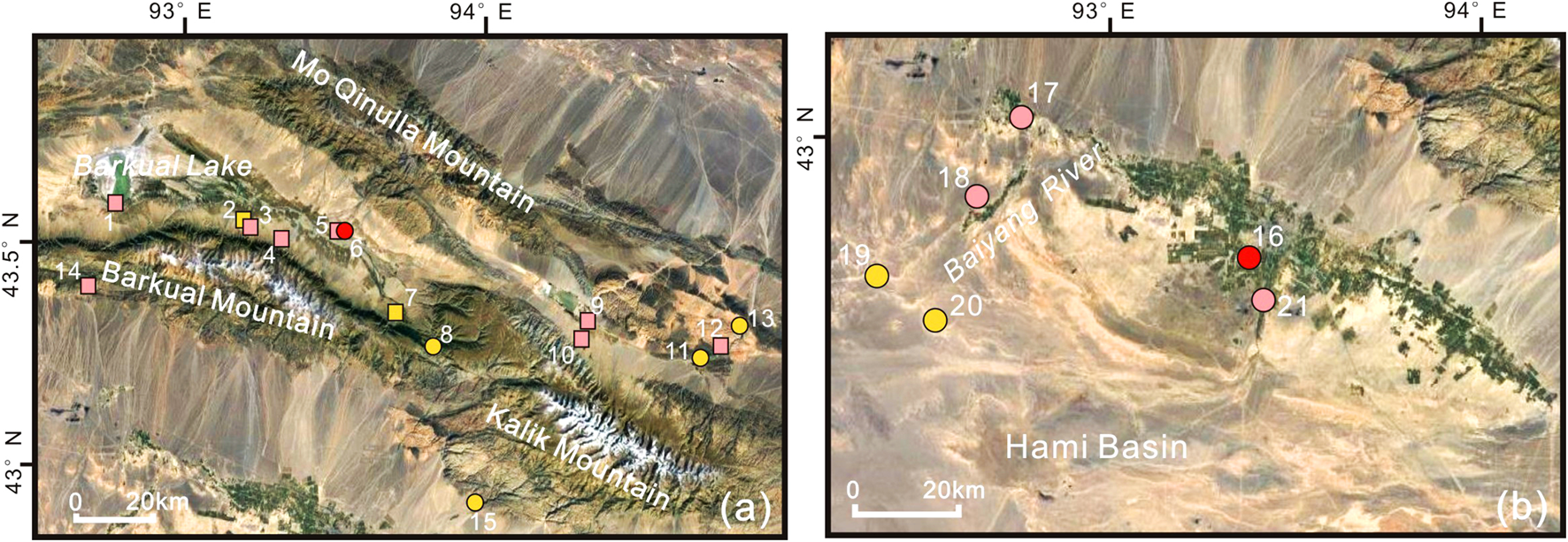
Topographic map of Eastern Tianshan Mountains and the sites mentioned in this study. (A) Areas on both sides of the Eastern Tianshan Mountains. 1. Haiziyan; 2. Xigou; 3. Dongheigou (Shirenzigou); 4. Hongshankou; 5. Qinggeda; 6. Nanwan; 7. Heigouliang; 8. Hanqigou; 9. Yanchi Gucheng; 10. Kuola; 11. Tuobeilang; 12. Baiqier 13. Xiagou; 14. Liushugou; 15. Huangtianshangmiaoergou I plot. (B) Hami Basin. 16. Tianshanbeilu; 17. Yanbulake; 18. Wupu; 19. Aisikexiaer; 20. South Aisikexiaer; 21. Sayituer.
4.5.1.1 On the alluvial fans
Eight sites (Figures 6A, 2.3.4.7.9.10.14.15) lie on the foothills of the Eastern Tianshan Mountains. Three sites of mid-late BA to EIA (Figures 6A, 3.4.9) and two EIA sites (Figures 6A, 2.7) are located on the alluvial fans. Two sites of mid-late BA to EIA (Figures 6A, 10.14) and one EIA cemetery (Figures 6A, 15) are located on top of the alluvial fan.
Botanical and isotope analysis indicates that the ancestors on the alluvial fans were engaged in animal herding, supplemented by farming and hunting. Cattle, horse, and sheep bones were unearthed at seven sites (Figures 6A, 2.3.4.7.9.10.14). Wild animal remains such as boar, deer, and antelope were unearthed at Liushugou (1400–400 BC; Figures 6A, 14) (Dong, 2021). The naked barley was identified at five sites (Figures 6A, 1.3.4.9.10); a few grains of wheat were unearthed at two sites (Figures 6A, 1.3.4), and a few millet were discovered at three sites (Figures 6A, 1.3.10) (Tian, 2018). Millstones and pestles were unearthed at several sites (Figures 6A, 1.3.9.10.14) (Tian, 2018; Ren et al., 2020; Tang et al., 2020; Xi et al., 2020; Dong, 2021). The abnormal phenomenon of horse vertebrae was identified at Dongheigou, suggesting that the residents had mastered equestrian riding (Li et al., 2016). The high δ15N values at Shirenzigou and Heigouliang suggest that the local population relied on a meat- or dairy-heavy diet (Li, 2020).
4.5.1.2 Mountain valleys
One site of mid-late BA to EIA (Figures 6A, 12) and three EIA cemeteries (Figures 6A, 8.11.13) have been found in this area. Sheep and horse bones, iron knives, and arrowheads were found at Tuobeiliang (Figures 6A, 11) (Wang J. X. et al., 2014). Sheep bones, bridle-bits, and arrowheads were found at Hanqigou (Figures 6A, 8) (Xi, 2014). Those remains show nomadic and hunting activities.
4.5.1.3 Alluvial fan margin oases
There are two sites from mid-late BA to EIA (Figures 6A, 1.5) and one BA cemetery (Figures 6A, 6). Qinggeda (1380–1127 BC; Figures 6A, 5) and Nanwan (1300-500 BC; Figures 6A, 6) were located in alluvial fan margin oasis areas near the river valley (Xi, 2014; Tian, 2018). Haiziyan (1300–800 BC; Figures 6A, 1) is located near an oasis around Barkual Lake. The archaeologists have excavated naked barley and bridle-bits of the late BA and iron knives and buckles, arrowheads, and ornaments of the EIA (Ren et al., 2020).
4.5.2 Hami Basin
The Hami Basin is between Barkual Mountain, Kalik Mountain, and the Gaxun Gobi. It is tectonically connected with the Turpan Basin. The terrain slopes from northeast to southwest, and the small rivers that originated in the Barkual-Karlik Mountains carry many sediments and form the alluvial fans, which constitute the sloping piedmont plain. The middle and upper plains are covered by gravel, with few plants growing. The lower part has more fine soil material, the terrain is gentle, and the diving depth is 5–7 m asl, forming Hami Oasis. The lowest area of the basin is Shar Lake, only 81 m asl above sea level. There is no water in the lake, only the salt shell. Six cemeteries lie on these alluvial plains and fan edge oases (Figure 6B).
4.5.2.1 Alluvial fan margin oases
Four cemeteries (Figures 6B, 16.17.18.21) are located on the alluvial fan margin oasis. Two BA cemeteries (Figures 6B, 16.21) are located in the Gobi Desert near the oasis. The δ15N values (ranging from 14.34‰ to 16.49‰) and the δ13C values (ranging from −13.97‰ to −16.40‰) of ten human bones at Tianshanbeilu (1940-1215 BC; Figures 6B, 16) show a heavy meat diet mixed with C3 and C4 plants (Zhang et al., 2010; Wang et al., 2017). Two cemeteries of mid to late BA to EIA (Figures 6B, 17.18) lie on an oasis surrounded by the Gobi in the Baiyang River Basin. Crops, pastries, and woolen fabrics were found in the Yanbulake (1000–500 BC; Figures 6B, 17) (Zhang et al., 1989; Chen, 1990). Leathers, millets, and wheat were discovered at Wupu (1050–450 BC; Figures 6B, 18) (Wang L. J. et al., 2020). Isotope analysis showed that the inhabitants consumed C4 plants (Dong, 2021).
4.5.2.2 Alluvial plains
Two EIA cemeteries (Figures 6B, 19.20) are located on the alluvial plain near the paleochannel of the Baiyang River. Many arrowheads and cereal processing remains were unearthed at South Aisikexiaer (650–350 BC), indicating hunting and probably farming activities (Wang and Dang, 2011; Dong, 2021). The mean δ13C values (−17.3‰ ± 0.9‰) and mean δ15N values (14.5‰ ± 1‰) of forty-three human bones show that the population relied heavily on animal products and consumed C3 plants here (Dong, 2021).
5 Discussion
5.1 Mixed agropastoral economy under grand geographical settings: The differentiation in Northern and Southern Xinjiang
The Tianshan range divides Xinjiang into two large geographical units. Northern Xinjiang mainly includes the Junggar Basin, the Bortala and Ili River Valleys, and northern areas of the middle and eastern Tianshan Mountains. Southern Xinjiang mainly includes Tarim Basin, as well as Turpan Basin and Hami Basin, respectively, in the middle and eastern Tianshan Mountains. In general, the Bronze Age to the early Iron Age in Xinjiang was characterized by various economic systems, including a diverse combination of pastoralism, agriculture, and hunter-gathering. However, the economic strategies are significantly different between northern Xinjiang and southern Xinjiang.
5.1.1 Northern Xinjiang
The Junggar Basin was deeply influenced by Scythian culture (Shui, 2016). Iron knives, harnesses, animal ornaments, and other artifacts of the steppe nomadic style were excavated in the early Iron Age tombs. Sheep bones and horse bones were unearthed, and the horse sacrifice behavior was evidenced (e.g., Figures 2A, 2.8.10.17, etc.), indicating a highly mobile animal husbandry economy.
The Western Tianshan Mountains region was deeply influenced by the Andronovo culture, which had a well-developed animal husbandry tradition (Guo, 2012). Evidence of migration (Cong et al., 2021) and seasonal transhumance (Jia, 2018) had been found at the Adonqolu and Husta Site (Figure 4A). In the Ili River Basin, sheep and horse bones, stone pestles, millstones, and arrowheads were unearthed in the sites and tombs (e.g., Figures 4B, 3.5.17.19.21–26.27). In short, the economy of the western Tianshan Mountains area was mainly animal husbandry, but evidence of plant remains has also been found in several sites (Figures 4A, 28; Figures 4B, 12.19).
The middle Tianshan Mountains area was influenced by many archaeological cultures from different directions. Sheep and horse bones were found at the northern foot of the middle Tianshan Mountains. Stone pestles, millstones, hoes (e.g., Figures 5A, 3.10.11), and plant remains (e.g., Figures 5A, 10.16) were also unearthed at the sites of this area. Large settlements, of ancient nomads, such as Shirenzigou, Hongshankou, and Dongheigou, were found at the northern foot of the eastern Tianshan Mountains. Wore horse vertebrae and high δ15N values of human bones showed nomadic activities (Li, 2020). Naked barley/wheat-millet plant remains were also unearthed at some sites (Figures 6A, 1.3.4.9.10). Furthermore, scattered remains were discovered in the southern Tianshan Mountains (e.g., Figures 5A, 14; Figures 6A, 14), indicating an animal husbandry economy.
5.1.2 Southern Xinjiang
The Xiaohe culture, which is in the Lop Nur Oasis on the eastern edge of the Tarim Basin, showed a mixed agropastoral economy (Shao, 2018). Sheep bones were discovered on Tarim Basin’s Northern edge sites (Figures 3A, 1.3.4.5.6.7.8.9), and stone sickle, stone pestle, wheat, and millet were discovered in oases on the edge of alluvial fans (Figures 3A, 4.8). In the oasis area near Bosten Lake, the remains of naked barley, wheat, and broomcorn from the Xintala Site indicate a predominantly agricultural economy. Irrigation systems were found at the Yuansha Gucheng Site (Figures 3D, 28). Food made from wheat and millet was discovered in Zhagunluke Cemetery on the Tarim Basin’s Southern edge (Figures 3D, 30).
The Subexi culture, with well-developed painted pottery, emerged in the oasis area of Turpan Basin (Shao, 2018). The animal remains (cattle, sheep, and horses), bows, arrows, and harness were unearthed from tombs in this area (Figure 5B). The seeds, including naked barley, wheat (Figures 5B, 17.19.21), broomcorn millet (Figures 5B, 17.19.20.21), and foxtail millet (Figures 5B, 17.19) were found in most tombs in Turpan Basin.
In the oasis area of Hami Basin, the Tianshanbeilu culture originated from the mix of Eastern and Western ancestors, which gradually developed into the Yanbulake culture (Shao, 2009; Shao, 2018). Bones of cattle, horses, and sheep (Figures 6A, 16.18.20); plant remains of naked barley, wheat, and millet (Figures 6A, 18); and tools such as stone pestles and millstones were found in this area (Figures 6A, 17.19.20). This evidence indicates that people in the Turpan and Hami Basins have worked in a mixed agropastoral economy.
To summarize, the Northern Xinjiang economy is primarily based on animal husbandry. The mixed agropastoral economy, which is primarily based on animal husbandry and supplemented by agriculture, has developed along the Tianshan Mountains. In Southern Xinjiang, however, there is an oasis agricultural economy or mixed agropastoral economy that is heavily based on agriculture. We believe there are two possible explanations. One is the difference in cultural traditions. Northern Xinjiang was strongly influenced by the Scythian culture, Andronovo culture, Northern steppe culture, and other nomadic cultures, so there are some animal husbandry traditions. But the Southern Xinjiang was strongly influenced by agricultural groups from Western and Central Asia. The other is the geographic and geomorphic setting. The sites in Northern Xinjiang are mainly located in mountain valleys, river valleys, and alluvial fans, which are more suitable for raising livestock. However, the sites and tombs in Southern Xinjiang are typically located in oases on the edges of alluvial fans, in basins, or around rivers and lakes in deserts, which are more suitable for cultivating crops.
5.2 Mountain valleys, alluvial fans and oases: The landforms where people choose to live
Previous research has shown that Xinjiang’s late Holocene palaeoenvironment was similar to modern times. That is, the climate was dry from the Bronze Age to the early Iron Age, and a lack of water rendered the vast deserts and Gobi uninhabitable. Our detailed examination of the geomorphic locations reveals that the sites in Xinjiang are mainly distributed in mountain valleys, alluvial fans, and oases (Table 1). There are two necessary environmental conditions: 1) Surface water sources, primarily rivers, lakes, gullies, springs, and so on, which are required for humans and livestock; 2) Fine-grained soil, including hydatogen sediments (alluvial or diluvial deposits) and eolian sediments (fine-grained weathering crust or loess), which are required for growing pasture or crops.
TABLE 1
| Area | Zone | Mountain vallys | Alluvial fans | Oases |
|---|---|---|---|---|
| Junggar Basin | Northern margin area of Junggar Basin | Tongtian Cave; Huahaizi No. 3; Wulasite; Zhelegabashi; Tuwaxincun | — | — |
| Western margin area of Junggar Basin | Baiyanghe | Abudulashuiku; Aletengyemushuiku; Sazicun | Xiakalangguer | |
| Tarim Basin | Northern margin area of Tarim Basin | Mohuchahan; Habuqihan I and II; Narenhabuqihangou; Daxigou No. 1; Daxigou No. 4; Qiaoenqiakeledeke | Baozidong M41; Duogang; Hejingzhonggongyeyuan | Kulansarike; Kezier; Keziertuershuiku; Karigayi; Tikemaike; Qunbake; Shanghuxiang; Xintala; Quhui |
| Southern margin area of Tarim Basin | — | Liushui; Gudaqi | Yuansha Gucheng; Northern-Niya; Zhagunluke; Jiawaairike | |
| Southwestern margin area of Tarim Basin | Jierzankale; Xiabandi | — | Wupaer | |
| Eastern margin area of Tarim Basin | — | — | Gumugou; Xiaohe | |
| Western Tianshan Mountains | Bortala River Basin | — | Adonqolu; Husta | Quanshuigou |
| Ili River Basin | Tangbalesayi; Jialekesikayinte; Qirentuohai | Suodunbulake; Biesikalagai; Saerhuobu | Ayousaigoukou; Qiafuqihai Area A Plot XV and Plot X; Yeshikelieke Cemetery A site; Qiongkeke | |
| Middle Tianshan Mountains | Areas on both sides of the middle Tianshan Mountains | Shimenzi; Sangongxiang; Xigou Ⅰ area; Xigou Ⅱ area; Sidaogou; Gangou; Saensayi; Ertanggou | Luanzagangzi; Baiyanghe; Dalongkou | Liangzhongchangyilian; Fukangfubeinongchangjijiandui; Chaiwobao; Shuinichang |
| Turpan Basin | — | Yuergou | Jiayi; Shengjindian; Subeixi; Yanghai | |
| Eastern Tianshan Mountains | Areas on both sides of the Eastern Tianshan Mountains | Hanqigou; Tuobeiliang; Baiqier; Xiagou | Xigou; Dongheigou (Shirenzigou); Hongshankou; Heigouliang; Yanchi Gucheng; Kuola; Liushugou; Huangtianshangmiaoergou Ⅰ plot | Haiziyan; Qinggeda; Nanwan |
| Hami Basin | — | — | Tianshanbeilu; Yanbulake; Wupu;Sayituer |
The geomorphic location of the sites mentioned in this study.
5.2.1 Mountain valleys and alluvial fans
The mountain valley includes the region near the lakes, rivers, and springs inside the mountains. Our analysis showed that many sites are located in the mountain valleys in the Altai Mountains, the Alatau-Borohoro Mountains, the middle and eastern Tianshan Mountains, and the Western and Southern Kunlun Mountains (Table 1). The ancient humans usually lived on platforms, terraces, or oases along alpine lakes or rivers. Most of these areas belong to the forest-grassland junction band.
An alluvial fan is a fan-shaped accumulation at the Mountain Pass (Yang, 2011). The piedmont alluvial fans are well-developed and of various shapes in arid Xinjiang. Groundwater is usually exposed between fans, forming spring water or a small oasis. There are also many gullies on the fans, providing abundant water sources for people and livestock. Our field investigation showed that the sites at the top of the alluvial fans are usually near small oases between fans, such as Adonqolu at the southern foot of the Alatau Mountains, Baiyanghe in the middle Tianshan Mountains, and Kuola in the eastern Tianshan Mountains. Some other sites are near the streams on the alluvial fan, including Husta in the Alatau Mountains, Luanzhanggangzi in the middle Tianshan Mountains, and Shirenzigou, Hongshankou, and Liushugou in the Eastern Tianshan Mountains.
The alluvial fan is often adjacent to the foothill meadow. The fine sediment transported by flowing water will provide suitable soil for pasture growth. Thus, there are favorable conditions for animal husbandry on the alluvial fans. The sites located in the valleys and alluvial fans showed a primarily pastoral economy supplemented by agriculture. Furthermore, sites with hunter components are mostly located in valleys or on alluvial fans that are adjacent to the mountains. Such as the Tuoganbai No. 2 and Tuwaxincun Cemeteries at the southern foot of the Altai Mountains; the Husta Site in the Bortala River Basin; the Mohuchahan Site on the Northern edge of the Tarim Basin; and the Liushui Cemetery on the Southern edge of the Tarim Basin; the Shimenzi Cemetery at the foothills of the middle Tianshan Mountains; and the Yuergou Site on the edge of the Turpan Basin. The nearby mountains are important for hunting activities. In Xinjiang, mountain forests and steppes are usually distributed between 1,000 and 2,000 m asl. This region always coincides with the maximum precipitation zone and is usually distributed in the mid-mountain zone cut by the river valley (Xinjiang Comprehensive Expedition Team et al., 1978). Therefore, this region is rich in pasture and often becomes an ideal place for herding activities. As it is usually adjacent to the mountainous forests, there are abundant wild animals and plants for hunting and gathering, which is a beneficial supplement to animal husbandry.
5.2.2 Various oases
Oases are areas with a good combination of soil and water in arid areas (Yang, 2011). There are alluvial fan edge oases, river valley oases, and desert oases in Xinjiang. The sites located at the fan edge oases along the Tianshan Mountains include Quanshuigou, Chaiwobao, Haiziyan, etc. The sites in the Grand River Valley are mainly distributed in the Ili Basin, such as Qiongkeke, Ayousaigoukou, etc. The sites at the desert oases are often adjacent to ancient river channels or lakes. They are mainly distributed around the Tarim Basin, such as Zhagunluke, Yuansha Gucheng, Xiaohe, etc.
In some cases, the landforms of the sites changed from oases to arid deserts or dry platforms over time. For example, studies of the Lop Nor showed that ancient people had lived in the oases deep in the desert 3,800 years ago. Research on the Xiaohe Cemetery indicates several lake development periods around the site (Zhang et al., 2015; Zhang Y. F. et al., 2017). The sporopollen and phytolith results indicate that the Xiaohe people lived in an oasis, growing plants such as Populus euphratica, Phragmites australis, and Typha, while some drought plants such as Ephedra, Salix, Artemisia, and Chenopodiaceae grew in the surrounding desert (Li et al., 2013; Qiu et al., 2014). Recently published research showed that a genetically isolated local population adopted neighboring pastoralist and agriculturalist practices in the early Bronze Age, which allowed them to settle and thrive along the shifting riverine oases of the Taklamakan (Zhang F. et al., 2021). Our field investigation at the Wupaer Site showed that the remains were buried in lacustrine sediments, indicating that the ancient people lived near a lake or in an oasis, which is quite different from nowadays.
Oases are generally groundwater outcropping zones with fine-grained and fertile soils. With excellent water and soil conditions, oases are suitable for planting crops and establishing settlements. As a result, agricultural activities are usually carried out in the oases, forming a mixed agropastoral economy. The materials in this paper show that the sites with a heavy proportion of agriculture are mainly distributed near oases. For example, tools such as a sickle, pestle, millstone, and hoe were found in the oases in the Turpan Basin, the Hami Basin, and on the Northern margin of the Tarim Basin (Figures 3A, 4.8.10.20; Figures 5B, 17.21; Figures 6B, 17.19.20). The barley, wheat, and millet were discovered in the Northern Tarim Basin alluvial fan margin oases (Figures 3A, 8.10). Barley (naked), wheat, and millet were unearthed in some oases of the Turpan Basin (Figures 5A, 17.19.20.21). In the desert oases inside the Tarim Basin, Xintala and Yuansha Gucheng also developed oasis agriculture. Isotopic results evidence that the people ate millet (Figures 5B, 18; Figures 6B, 16.18).
In general, the valleys or alluvial fans close to the mountains have shown a mixed herding-hunting economy, and the sites near the large oases have shown a mixed agropastoral economy with a high proportion of agriculture (Table 2).
TABLE 2
| Period | Zone | Site | Geomorphic area | Economic strategy | Others | |||||
|---|---|---|---|---|---|---|---|---|---|---|
| Mountain vallys | Alluvial fans | Oases | Others | Agriculture | Husbandry | Hunting | ||||
| Bronze Age | Northern margin area of Junggar Basin | Tongtian Cave | √ | √ | √ | |||||
| Ayituohan No.1 | Planation surface in the south of Altai Mountain | √ | √ | √ | ||||||
| Tuoganbai No.2 | √ | √ | √ | Existing Sacrificial remains | ||||||
| Western margin area of Junggar Basin | Xiakalangguer | √ | √ | √ | ||||||
| Northern margin area of Tarim Basin | Xintala | √ | √ | |||||||
| Eastern margin area of Tarim Basin | Xiaohe | √ | √ | √ | √ | Existing Sacrificial remains | ||||
| Gumugou | √ | √ | √ | √ | ||||||
| Bortala River Basin | Adonqolu | √ | √ | √ | Winter camps | |||||
| Husta | √ | √ | √ | √ | High-grade residential or sacrificial site | |||||
| Quanshuigou | √ | √ | √ | Metalurgical sites | ||||||
| Hami Basin | Tianshanbeilu | √ | √ | √ | √ | |||||
| Mid-late Bronze Age to Early Iron Age | Northern margin area of Tarim Basin | Chawuhu No.1 | √ | √ | √ | √ | ||||
| Chawuhu No.4 | √ | √ | √ | |||||||
| Mohuchahan | √ | √ | √ | |||||||
| Southern margin area of Tarim Basin | Liushui | On low hills and alluvial fans | √ | √ | Existing Sacrificial remains | |||||
| Southwestern margin area of Tarim Basin | Wupaer | √ | √ | |||||||
| Ili River Basin | Jirentaigoukou | Loess platforms on both sides of the river valley | √ | √ | Surrounded by metallurgical remains | |||||
| Qialegeer | √ | |||||||||
| Kalasu | √ | |||||||||
| Middle Tianshan Mountains | Luanzagangzi | √ | √ | |||||||
| Sidaogou | √ | √ | √ | |||||||
| Saensayi | √ | √ | √ | |||||||
| Turpan Basin | Yanghai | √ | √ | √ | √ | |||||
| Eastern Tianshan Mountains | Haiziyan | √ | √ | √ | ||||||
| Shirenzigou | √ | √ | √ | |||||||
| Liushugou | √ | √ | √ | √ | ||||||
| Kuola | √ | √ | √ | Existing Sacrificial remains | ||||||
| Yanchi Gucheng | √ | √ | √ | |||||||
| Hami Basin | Yanbulake | √ | √ | √ | √ | |||||
| Early Iron Age | Northern margin area of Junggar Basin | Huahaizi No.3 | √ | Ceremonial center of early nomadic society | ||||||
| Tuwaxincun | √ | √ | √ | Existing Sacrificial remains | ||||||
| Kalasu | planation surface in the south of Altai Mountain | √ | √ | |||||||
| Northern margin area of Tarim Basin | Duogang | √ | √ | √ | √ | |||||
| Tikemaike | √ | Metallurgical sites | ||||||||
| Qunbake | √ | √ | √ | √ | ||||||
| Southern margin area of Tarim Basin | Yuansha Gucheng | √ | √ | √ | √ | |||||
| Zhagunluke | √ | √ | √ | √ | ||||||
| Ili River Basin | Qiongkeke | √ | √ | √ | Existing Sacrificial remains | |||||
| Middle Tianshan Mountains | Shimenzi | √ | √ | √ | ||||||
| Turpan Basin | Yuergou | √ | √ | √ | √ | |||||
| Shengjindian | √ | √ | √ | √ | ||||||
| Subeixi | √ | √ | √ | √ | ||||||
| Jiayi | √ | √ | √ | √ | ||||||
| Eastern Tianshan Mountains | Heigouliang | √ | √ | √ | Existing Sacrificial remains | |||||
| Hami Basin | South Aisikexiaer | Alluvial plain | √ | √ | √ | Existing Sacrificial remains | ||||
Geomorphic area and economic strategy of important sites and cemeteries.
It should be noted that people have most likely lived in different geomorphic areas during different seasons since the Bronze Age (Jia, 2018). Therefore, the sites showing different economic strategies in various landforms probably also indicate that people will engage in different economic activities along with their seasonal migration. The complex combination of stock raising, crop planting, and hunting depends largely on different landforms, microenvironments, and local ecology.
5.3 Special site, social complexity and the trend of nomadism
Sites of special nature in Xinjiang include ritual sites and metallurgical sites. Six ritual sites were found, including Huahaizi No.3 in the northern margin of Junggar Basin; Qiongkeke in the Ili River Valley; Hongshangou on the northern edge of Tarim Basin; Dongheigou, Hongshankou, and Kuola Site in the eastern Tianshan Mountains. Because these ritual sites are all close to certain large center settlements, we believe they probably serve some special purpose. One of the most typical ritual sites is Huahaizi No. 3. This location is on the lakeshore in a valley surrounded by the Altai Mountains. There are three alpine lakes formed by melting alpine snow, and surrounded by some small rivers and lakes. Deer-stone remains were found on this site. The excavators speculated that it would probably be a nomadic ceremonial center to hold the summer rituals (Guo et al., 2016). The nomads might have chosen this special landform to hold regular ritual activities because it is around the alpine lake at the top of the high mountain; it is easy to communicate with heaven and strengthen people’s cohesion.
The metallurgical sites are mainly distributed in the Ili Valley and the Hami Basin. The metallurgical site in the Western Tianshan Mountains includes Quanshuigou and Jirentaigoukou. There are three ancient copper mine sites near the Jirentaigoukou: Nulasai, Yuantoushan, and Kezilekezangbei (Wang et al., 2019). The flat terrain of Bortala Valley and Kashi Valley provides the possibility of East-West communication. The favorable environmental conditions of the fan margin oasis and the loess platform lay the foundation for developing a stable mixed agropastoral economy, which probably gave rise to metallurgical behavior (Zhang Y. P. et al., 2021). The Tikemaike is located in the river valley between the Queletage Mountain and the Kuche River, with a rich iron ore mine nearby. The relics, such as refining slag, flow pipes, and pottery pieces, are distributed on the slopes of the mountain range, visible on the surface (Ruan et al., 2016). In the eastern Tianshan Mountains region, the archaeological investigation has found ancient turquoise mines, turquoise debris, and house relics in both the Heishanling and Tianhudong Sites (Li et al., 2019). It could be concluded that the metallurgical sites are generally located in landforms with good transportation and favorable soil and water conditions, such as river valleys or oases. Besides, there is also evidence to show that some metallurgical sites are close to mining sources. From the perspective of spatial distribution, the metallurgical sites in the western Tianshan Mountains may be more affected by western metallurgical technology (Tan, 2022). The Ili Valley consists of three mountain ranges that gradually contracted from west to east, to the west it is connected with the Zhetysu region of Kazakhstan (Tan, 2022). Multiple east-west river systems provide transportation routes for people to communicate and spread metallurgical technology. The turquoise metallurgy technology in the Hami Basin of the Eastern Tianshan Mountains is more likely to be influenced by the eastern central plain culture (Li et al., 2020; Xian et al., 2020).
There are six large settlements with an area of more than 7 km2. Archaeologists have excavated high-level burials at the Jirentaigoukou Site, indicating the emergence of social complexity in the Bronze Age (Yuan, 2022). Husta, Adonqolu, Shirenzigou, Hongshankou, and Kuola are among the other major central settlements. These sites are located in large river valleys or alluvial fans with abundant water and pastures. These microenvironments with favorable soil-water composition and high land-bearing capacity often have homogeneity in a large region. That is to say, there are many similar microenvironments around. As a result, there are usually many homochronous sites around the central site. Under similar ecological conditions, these people developed similar cultures and probably communicated frequently with each other. As the population density increased, social complexity arose, and the central settlement appeared.
The sites that lasted a long time have shown signs of normalization. For example, the excavations at Jirentaigoukou and Haiziyan revealed an obvious tendency from large and complex houses in the late Bronze Age to small and simple dwellings in the early Iron Age. The remains of grain storage, processing, and cooking functions are gradually disappearing (Haiziyan) (Ren et al., 2020). Most scholars believe that the early nomadic economy developed from the pastoralism of the Bronze Age (Shao and Wu, 2020). Ethnological studies suggested that the Husta and Adonqolu had developed a seasonal transhumance economy and that summer pasture and winter pasture had appeared (Cong et al., 2018; Jia, 2018; Jia, 2019). However, the highly mobile grassland nomadic economy was not formed until the early Iron Age (Shao and Wu, 2020).
Although it is necessary to consider the economy, technology, society, politics, and other factors, scholars believe that the final appearance of nomadism needs to be stimulated by a specific motivator, and most of the cases are related to environmental changes (Gumilev, 1996; Tairov, 2003). Vinogradov (Vinogradov and Epimakhov, 2000) and Xi (2014) et al. believed that the changes in economic organization, environmental resources, and related metallurgical production caused by drought or cold climate events were the causes of nomadism. According to An et al. (2020), the humidity has caused pastures to thrive for the past 4,000 years, hastening the process of nomadism. Based on the materials we have sorted out, both animal husbandry and agriculture were greatly developed from the Bronze Age to the early Iron Age. During the Bronze Age, the differentiation between animal husbandry and agriculture did not occur because of an undeveloped economy and technology (Shao and Wu, 2020). Since 4,000 BP, the ancient climate in Xinjiang has become wetter, which probably promoted the growth of pasture and crops, resulting in animal husbandry and agriculture development. Thus, the scale and specialization of animal husbandry increased, which led to the differentiation of herding and farming activities. Finally, specialized and highly mobile nomadism emerged in the early Iron Age.
6 Conclusion
We have drawn the three tentative conclusions listed below based on analyzing the geomorphic patterns and subsistence modes of Xinjiang’s Bronze Age and early Iron Age sites.
(1) There are different economic strategies between southern and northern Xinjiang. Northern Xinjiang’s economy was primarily based on animal husbandry; areas along the Tianshan Mountains had a mixed agropastoral economy that was primarily based on animal husbandry and supplemented by agriculture. In southern Xinjiang, there is an typical oasis agricultural economy or mixed agropastoral economy heavily based on agriculture.
(2) Certain regions of the landscape with surface water sources and fine-grained soil cover were inhabited by ancient humans. This consists primarily of mountain valleys, alluvial fans, and various oases. The presence of hunting activities is heavily influenced by the distance to the mountains, whereas adequately sized oases favor agriculture. Accordingly, sites near mountains are more likely to have developed a mixed pastoral-hunting economy, sites in mountain valleys or on alluvial fans are more likely to have developed a livestock-based economy, and oases of large size are more likely to have developed a mixed agropastoral economy.
(3) Some unique ritual sites are found in specific geomorphic regions (e.g., near alpine lakes); metallurgical sites are more likely along the geographical channel. Large settlements are usually situated in vast river valleys or alluvial fans with ample water and pasture. Under similar microenvironmental conditions, more similar cultural and economic patterns tend to evolve amongst sites within the same area, resulting in more significant central settlements and social complexity.
This paper presents a preliminary discussion on the economic strategy and its differentiation between geographic units and landforms, which is helpful to comprehend the “man-land” dynamics in Xinjiang. More detailed case studies, however, are still required to promote an in-depth understanding of the complex mixed agropastoral economy from the Bronze Age to the early Iron Age.
Statements
Data availability statement
The original contributions presented in the study are included in the article/Supplementary Material, further inquiries can be directed to the corresponding author.
Author contributions
JZ designed the research. JZ and CY performed the research. JZ and CY analyzed the data. CY and JZ completed writing. XY edited the figures.
Funding
This research was funded by the National Natural Science Foundation of China (41971114) and the important project of National Social Science Foundation of China (21&ZD223, 18ZDA172).
Acknowledgments
The authors are greatful to Yixian Lin for helping to edit the manuscript.
Conflict of interest
The authors declare that the research was conducted in the absence of any commercial or financial relationships that could be construed as a potential conflict of interest.
Publisher’s note
All claims expressed in this article are solely those of the authors and do not necessarily represent those of their affiliated organizations, or those of the publisher, the editors and the reviewers. Any product that may be evaluated in this article, or claim that may be made by its manufacturer, is not guaranteed or endorsed by the publisher.
References
1
An C. B. Zhang M. Wang W. Liu Y. Duan F. T. Dong W. M. (2020). The characteristics of Xinjiang's geographical environment and the formation of the pattern of agriculture and animal husbandry. Sci. China Earth Sci.50 (2), 295–304.
2
An J. Y. Yuan J. (1998). Research report on animal skeletons at Chawuhu goukou cemetery No. 1 and 3, hejing county. Xinjiang. Archaeol.7, 63–68.
3
Chan A. Shao H. Q. (2018). Современные решения актуальных проблем евразийской археологии. Сборник научных трудов 2. Contemp. Solutions Curr. Problems Eurasian Archaeol. Collect. Sci. Pap.2, 55–59.
4
Chang C. (2002). The evolution of steppe communities from the bronze Age through medieval periods in southeastern Kazakhstan (Zhetysu): The Kazakh-American talgar project 1994-2001. Sweet Briar, Virginia: Sweet Briar College.
5
Chen F. H. Jia J. Chen J. H. Li G. Q. Zhang X. J. Xie H. C. et al (2016). A persistent Holocene wetting trend in arid central Asia, with wettest conditions in the late Holocene, revealed by multi-proxy analyses of loess-paleosol sequences in Xinjiang, China. Quat. Sci. Rev.146, 134–146. 10.1016/j.quascirev.2016.06.002
6
Chen F. H. Yu Z. C. Yang M. L. Ito E. Wang S. M. Madsen D. B. et al (2008). Holocene moisture evolution in arid central Asia and its out-of-phase relationship with Asian monsoon history. Quat. Sci. Rev.27 (3-4), 351–364. 10.1016/j.quascirev.2007.10.017
7
Chen G. (1990). A little discussion of Yanbulake culture. West. Regions Stud.1, 81–96.
8
Chen X. L. (2017). New progress in analysis methods of carbon and nitrogen stable isotopes and agricultural archaeology. Agric. Archaeol.154 (6), 13–25.
9
Chen X. L. Yu J. J. You Y. (2017). Horse burial customs in Kalasu cemetery of Xinjiang seen from stable carbon and nitrogen isotope. West. Regions Stud.108 (4), 89–143. 10.16363/j.cnki.xyyj.2017.04.008
10
Cong D. X. Chen G. (1991). Brief report on the second and third excavations of qunbake cemetery in luntai county, Xinjiang. Archaeology8, 684–771.
11
Cong D. X. Jia X. B. Guo W. Shang G. J. Ge L. (2013). The Adonqolu site and cemetery in wenquan county, Xinjiang. Archaeology550 (7), 25–32.
12
Cong D. X. Jia X. B. Jia W. M. Alison B. Paula D. M. (2018). Mountaintop remains of the bronze age by the Bortala River Valley, Xinjiang. West. Regions Stud.110 (2), 138–150. 10.16363/j.cnki.xyyj.2018.02.013
13
Cong D. X. Zhao C. Y. Jia W. M. (2021). Human migration and dietary structure of the adunqiaolu site in Xinjiang: A pilot study. Jianghan Archaeol.177 (6), 233–239.
14
Debaine F. C. Debaine F. Idriss A. (2010). “The Taklimakan oases: An environmental evolution shown through geoarchaeology,” in Water and sustainability in arid regions. Editors Schneier-MadanesG.CourelM. F. (Dordrecht: Springer), 181–202. 10.1007/978-90-481-2776-412
15
Dodson J. R. Li X. Zhou X. Zhao K. Sun N. Atahan P. (2013). Origin and spread of wheat in China. Quat. Sci. Rev.72, 108–111. 10.1016/j.quascirev.2013.04.021
16
Dong G. H. Du L. Y. Yang L. Lu M. X. Chou M. H. Li H. M. et al (2022). Dispersal of crop-livestock and geographical-temporal variation of subsistence along the Steppe and Silk Roads across Eurasia in prehistory. Sci. China Earth Sci.52 (8), 1476–1498.
17
Dong W. M. An C. B. Zhang T. N. Alifujiang N. Z. (2022a). Subsistence strategies of people from Chawuhu culture in the middle of tianshan mountains: A case study of mohuchahan site from hejing county. Quat. Sci.42 (1), 80–91. 10.11928/j.issn.1001-7410.2022.01.07
18
Dong W. M. An C. B. Yu J. J. Chen X. L. (2022b). The subsistence strategy of the residents in the bronze-early altay region and its implications-evidence from bone stable isotopes. West. Regions Stud.125 (1), 45–170. 10.16363/j.cnki.xyyj.2022.01.005
19
Dong W. M. (2021). Recipes of the prehistoric residents of the Hami Basin. Shanghai: Fudan University Press.
20
Doumani P. Frachetti M. D. Beardmore R. Schmaus T. M. Spengler R. N. III Mar'yashev A. N. (2015). Burial ritual, agriculture, and craft production among Bronze Age pastoralists at Tasbas (Kazakhstan). Archaeol. Res. Asia1-2, 17–32. 10.1016/j.ara.2015.01.001
21
Du S. Q. Ren M. (2017). A preliminary study on the archaeological and cultural remains from the bronze age to the early iron age in changji, Xinjiang. West. Regions Stud.106 (2), 48–56. 10.16363/j.cnki.xyyj.2017.02006
22
Feng Z. D. (2017). Climate and hydrological changes in northern Xinjiang and its surrounding areas in the past 10,000 years. Lanzhou: Lanzhou University Press.
23
Frachetti M. D. (2009). Differentiated landscapes and non-uniform complexity among bronze age societies of the eurasian steppe. Soc. Complex. Prehist. Eurasia3, 19–46. 10.1017/CBO9780511605376.004
24
Frachetti M. D. (2012). Multiregional emergence of mobile pastoralism and nonuniform institutional complexity across eurasia. Curr. Anthropol.53 (1), 2–38. 10.1086/663692
25
Frachetti M. D. (2008). Pastoralist landscapes and socialinteraction in bronze Age eurasia. Berkeley: University of California Press.
26
Frachetti M. D. Smith C. E. Traub C. M. Williams T. (2017). Nomadic ecology shaped the highland geography of Asia’s Silk Roads. Nature543 (7644), 193–198. 10.1038/nature21696
27
Frachetti M. D. Spengler R. N. Fritz G. J. Mar'yashev A. N. (2010). Earliest direct evidence for broomcorn millet and wheat in the central Eurasian steppe region. Antiquity84 (326), 993–1010. 10.1017/s0003598x0006703x
28
Gong Y. W. Yang Y. M. Ferguson D. K. Tao D. W. Li W. Y. Wang C. S. et al (2011). Investigation of ancient noodles, cakes, and millet at the Subeixi Site, Xinjiang, China. J. Archaeol. Sci.38 (2), 470–479. 10.1016/j.jas.2010.10.006
29
Gumilev L. N. (1996). Isioki ritma kochevoi kultury sredinnoi aziyi: Opyt istorikogeographicheskogo sinieza. Nar. I Afriki4, 25–46.
30
Guo W. (2012). Archaeological research on late prehistoric society in Xinjiang. Shanghai: Shanghai Ancient Books Press.
31
Guo W. Zhang H. L. Lv E. G. Wu D. J. Zheng J. Yao R. W. et al (2016). The excavation of the Huahaizi No. 3 site in qinghe county, Xinjiang. Archaeology588 (9), 25–37.
32
Han J. Y. (2007). Bronze Age and early iron Age culture in Xinjiang. Beijing: Heritage Press.
33
Han J. Y. Chen X. L. (2017). The discovery and preliminary understanding of the bronze age remains in Quanshuigou, shuanghe city, Xinjiang. West. Regions Stud.105 (1), 142–143. 10.16363/j.cnki.xyyj.2017.01.014
34
Han J. Y. (2021). The three stages of early sino-western cultural interactions. Acta Archaeol. Sin.222 (3), 317–338.
35
Hartman G. (2011). Are elevated δ15N values in herbivores in hot and arid environments caused by diet or animal physiology?Funct. Ecol.25 (1), 122–131. 10.1111/j.1365-2435.2010.01782.x
36
Haruda A. (2018). Regional pastoral practice in central and southeastern Kazakhstan in the Final Bronze Age (1300–900 BCE). Archaeol. Res. Asia15, 146–156. 10.1016/j.ara.2017.09.004
37
He D. X. (1999). Ancient tombs in Shanghuxiang, kuerle city, Xinjiang. Cult. Relics2, 32–40.
38
Hedges R. E. M. Reynard L. M. (2007). Nitrogen isotopes and the trophic level of humans in archaeology. J. Archaeol. Sci.34 (8), 1240–1251. 10.1016/j.jas.2006.10.015
39
Hou Z. J. (2016). Archaeological discovery of hongshan tombs in heshuo county, Xinjiang in 2015. West. Regions Stud.103 (3), 132–135+2. 10.16363/j.cnki.xyyj.2016.03.017
40
Huang Y. P. (2008). Animal bone analysis of Yuansha Gucheng site in Keriya River, yutian county, Xinjiang. A Collect. Stud. Archaeol.0, 532–540.
41
Jia W. M. (2018). Archaeological observations on prehistoric nomadic activities: Analysis of prehistoric settlements in the western tianshan mountains of Xinjiang. West. Regions Stud.111 (3), 63–145.
42
Jia X. B. (2019). Major discoveries of the excavation at Husta, wenquan county, Xinjiang, China. West. Regions Stud.113 (1), 139–141. 10.16363/j.cnki.xyyj.2019.01.012
43
Jiang H. E. Lv E. G. Zhang Y. N. (2021). A consideration of the lifestyle of the ancient Yanghai people in turfan. Turfanological Res.27 (1), 41–154. 10.14087/j.cnki.65-1268/k.2021.01.005
44
Jiang H. G. Wu Y. Wang H. H. Ferguson D. K. Li C. S. (2013). Ancient plant use at the site of Yuergou, Xinjiang, China: Implications from desiccated and charred plant remains. Veg. Hist. Archaeobotany22 (2), 129–140. 10.1007/s00334-012-0365-z
45
Jiang H. G. Zhang Y. B. Lv E. G. Wang C. S. (2014). Archaeobotanical evidence of plant utilization in the ancient turpan of Xinjiang, China: A case study at the shengjindian cemetery. Veg. Hist. Archaeobotany24 (1), 165–177. 10.1007/s00334-014-0495-6
46
Li J. F. Abuduresule I. Hueber F. M. Li W. Y. Hu X. J. Li Y. Z. et al (2013). Buried in sands: Environmental analysis at the archaeological site of Xiaohe cemetery, Xinjiang, China. PLoS ONE8 (7), e68957. 10.1371/journal.pone.0068957
47
Li Y. Q. (2020). Agriculture and palaeoeconomy in prehistoric Xinjiang, China (3000–200 BC). Veg. Hist. Archaeobotany30, 287–303. 10.1007/s00334-020-00774-2
48
Li Y. X. Tan Y. C. Jia Q. Zhang D. Y. Yu J. J. Duan C. W. et al (2019). Preliminary investigation of two turquoise mining sites in Hami, Xinjiang. Archaeol. Cult. Relics236 (6), 22–27.
49
Li Y. X. Yu J. J. Xian Y. H. Tan Y. C. Zhu Z. Z. Cao K. et al (2020). A survey of the ancient turquoise mining sites at heishanling in ruoqiang, Xinjiang. Cult. Relics771 (8), 4–13. 10.13619/j.cnki.cn11-1532/k.2020.08.001
50
Li Y. You Y. Liu Y. T. Xu N. Wang J. X. Ma J. et al (2016). The study on the vertebrae abnormality of the Shirenzigou and xigou sites in Xinjiang. Archaeology580 (1), 108–120.
51
Lin M. C. (2016). Seima-turbino culture and the proto-silk road. Chin. Cult. Relics1-2, 241–262. 10.21557/ccr.48032340
52
Liu X. T. Guan B. (2002). Important harvests of prehistoric archaeology in the Ili River Valley in Xinjiang. West. Regions Stud.4, 106–108. 10.16363/j.cnki.xyyj.2002.04.019
53
Liu Y. Liu L. Y. Zhang M. Zhang Y. An C. B. (2021). A preliminary study on the estimation of the population size of the Saensayi and Yanghai sites in Xinjiang in different times. Quat. Sci.41 (1), 267–275.
54
Marino B. D. McElroy M. B. (1991). Isotopic composition of atmospheric CO2 inferred from carbon in C4 plant cellulose. Nature349 (6305), 127–131. 10.1038/349127a0
55
Qiu Z. W. Yang Y. M. Shang X. Li W. Y. Abuduresule Y. Hu X. J. et al (2014). Paleo-environment and paleo-diet inferred from early bronze age cow dung at Xiaohe cemetery, Xinjiang, NW China. Quat. Int.349, 167–177. 10.1016/j.quaint.2014.03.029
56
Qu Y. T. Hu X. J. Wang T. T. Yang Y. M. (2020). Early interaction of agropastoralism in eurasia: New evidence from millet-based food consumption of afanasyevo humans in the southern Altai mountains, Xinjiang, China. Archaeol. Anthropol. Sci.12 (8), 195–207. 10.1007/s12520-020-01094-2
57
Ren M. Ma J. Xi T. Y. Tian Y. L. Jiang X. L. (2020). Brief report on the excavation of the haiziyan site in balikun, Xinjiang in 2017. Cult. Relics775 (12), 21–36. 10.13619/j.cnki.cn11-1532/k.2020.12.002
58
Ruan Q. R. Hu W. L. Zhang J. Guan B. Liu Y. S. Wang Y. et al (2014). Brief report on the excavation of the wutulan cemetery in nileke county, Xinjiang. Cult. Relics703 (12), 50–63. 10.13619/j.cnki.cn11-1532/k.2014.12.002
59
Ruan Q. R. Wang Y. Q. Alifu N. Z. (2012). Excavation of Koksu West Cemetery No. 2 in tekes county, Xinjiang. Archaeology540 (9), 3–101.
60
Ruan Q. R. Wang Y. Q. Ni J. T. Yu Y. J. Liu Y. S. (2016). Brief report on excavation of the kuche-ehuobulake railway area, Kuche county, Xinjiang. West. Archaeol.1, 29–50.
61
Shao H. Q. (2009). Early collision and fusion of Eastern and Western cultures - from the evolution of cultural pattern in Xinjiang's prehistoric period. Soc. Sci. Front171 (9), 146–150.
62
Shao H. Q. (2018). The evolution of the prehistoric cultural pattern in Xinjiang and its relationship with the surrounding culture. Beijing: Science Press.
63
Shao H. Q. Wu Y. T. (2020). An analysis of the origin of early nomadic culture. North. Cult. Relics141 (1), 28–37. 10.16422/j.cnki.1001-0483.20200319.004
64
Shao K. L. Zhang J. P. Cong D. X. Jia W. M. Cui A. N. Wu N. Q. (2019). Analysis of plant microfossils reveals the ancient survival strategy of the Adunqiaolu site in Xinjiang, China. Quat. Sci.39 (1), 37–47. 10.11928/j.issn.1001-7410.2019.01.04
65
Shevchenko A. Yang Y. M. Knaust A. Thomas H. Jiang H. E. Lu E. G. et al (2014). Proteomics identifies the composition and manufacturing recipe of the 2500-year old sourdough bread from Subeixi cemetery in China. J. Proteomics105, 363–371. 10.1016/j.jprot.2013.11.016
66
Shui T. (2016). The formation and influence of the interaction circle in the Altai Region during the Bronze Age - with the discovery of China as the main line. Anc. Civilizations Period.10 (0), 262–267.
67
Si Y. Lv E. G. Li X. Jiang H. G. Hu Y. W. Wang C. S. (2013). Exploration of human diets and populations from the Yanghai tombs, Xinjiang. Sci. Bull.58 (15), 1422–1429. 10.1360/972012-1007
68
Spengler R. N. III Frachetti M. D. Doumani P. N. (2014). Late bronze age agriculture at Tasbas in the Dzhungar mountains of eastern Kazakhstan. Quat. Int.348, 147–157. 10.1016/j.quaint.2014.03.039
69
Spengler R. N. III Miller A. V. Schmaus T. Matuzevičiūtė G. M. Miller B. K. Wilkin S. et al (2021). An imagined past?: Nomadic narratives in central asian archaeology. Curr. Anthropol.62, 251–286. 10.1086/714245
70
Spengler R. N. III Ryabogina N. Tarasov P. E. Wagner M. (2016). The spread of agriculture into northern central Asia: Timing, pathways, and environmental feedbacks. Holocene26 (10), 1527–1540. 10.1177/0959683616641739
71
Spengler R. N. III Willcox G. (2013). Archaeobotanical results from Sarazm, Tajikistan, an early bronze age settlement on the edge: Agriculture and exchange. Environ. Archaeol.18 (3), 211–221. 10.1179/1749631413y.0000000008
72
Sun B. G. Chen G. (1987). Brief report on the first excavation of the qunbake cemetery in luntai, Xinjiang. Archaeology11, 987–1061.
73
Tairov A. D. (2003). Izmeneniya klimata stepei i lesostepei Tsentral'noi Evrazii vo II–I tys. do n.e. Materialy k istoricheskim rekonstruktsiyam.Chelyabinsk. Krokus.
74
Tan Y. C. (2022). “The study on early bronze metallurgy within the regins of west tianshan mountains in Xinjiang during the 2nd mellenium BC,”. PhD dissertation (Beijing: University of Science and Technology Beijing).
75
Tang Y. P. Fu Y. H. Xi T. Y. Wang W. Z. Rouzi M. Ma J. et al (2020). Brief report on archaeological excavation of Kuola site in yiwu county, Xinjiang, from 2017 to 2018. Archaeology771 (8), 14–28. 10.13619/j.cnki.cn11-1532/k.2020.08.002
76
Tian D. Ma J. Ren M. Xi T. Y. Wang J. X. Zhao Z. J. (2021). Barley production in early Xinjiang: Evidence from archaeobotanical remains in the Shirenzigou site, northern tianshan mountains. Agric. Hist. China40 (3), 44–55.
77
Tian D. (2018). “Phytoarchaeological research in the Eastern Tianshan area in the 1st millennium BC,”. PhD dissertation (Xi’an: Northwestern University).
78
Vinogradov N. Epimakhov A. (2000). From a settled way of life to nomadism. Variants in models of transition. (Kurgans, ritual sites, and settlements eurasian bronze and iron Age). Oxford: Archaeopress, 240–246.
79
Wang B. Lu L. P. Xu H. H. Ai A. N. W. E. Mai Y. S. F. (2003). Excavation of Zhagunluke No.1 in charchan, xingjiang. Acta Archaeol. Sin.148 (1), 89–176.
80
Wang J. X. Xi L. (2009). Archaeological research on early nomadic cultural settlements in the Eastern Tianshan Mountains area. Archaeology496 (1), 28–114.
81
Wang J. X. Zhou X. M. Xi T. Y. Ye Q. Li M. Y. Ma J. (2014). A preliminary report on the 2009 excavation of the Tuobeiliang cemetery in yiwu county, Xinjiang. Archaeol. Cult. Relics204 (4), 24–121.
82
Wang L. J. Wang Y. Q. Li W. Y. Spate M. Reheman K. Sun Q. L. et al (2020). Inner Asian agropastoralism as optimal adaptation strategy of Wupu inhabitants (3000–2400 cal BP) in Xinjiang, China. Holocene31 (2), 203–216. 10.1177/0959683620941139
83
Wang L. Xiao G. Q. Liu Z. J. Lv E. G. Wu Y. (2014). Brief report on excavation of Jiayi cemetery in turpan, Xinjiang. Turfanological Res.13 (1), 19–161. 10.14087/j.cnki.65-1268/k.2014.01.015
84
Wang Q. Ma Z. K. Chen Q. H. Ma Y. C. Ruan Q. R. Wang Y. Q. et al (2020). Microbotanical remains provide direct evidences for the functional study of stone tools from Jartai Pass site in Nilka County, Xinjiang. Quat. Sci.40 (2), 450–461. 10.11928/j.issn.1001-7410.2020.02.15
85
Wang T. T. Dong W. Chang X. E. Yu Z. Y. Zhang X. Y. Wang C. S. et al (2017). Tianshanbeilu and the isotopic millet road: Reviewing the late neolithic/bronze age radiation of human millet consumption from north China to europe. Natl. Sci. Rev.6 (5), 1024–1039. 10.1093/nsr/nwx015
86
Wang W. Feng Z. D. (2013). Holocene moisture evolution across the Mongolian plateau and its surrounding areas: A synthesis of climatic records. Earth Sci. Rev.122, 38–57. 10.1016/j.earscirev.2013.03.005
87
Wang W. Liu Y. Duan F. T. Zhang J. Liu X. Y. Reid R. E. B. et al (2020). A comprehensive investigation of Bronze Age human dietary strategies from different altitudinal environments in the Inner Asian Mountain Corridor. J. Archaeol. Sci.121, 105201–201. 10.1016/j.jas.2020.105201
88
Wang Y. Q. Dang Z. H. (2011). New archaeological discovery of the south Aisikexiaer cemetery in wubao, Hami, Xinjiang. West. Regions Stud.82 (2), 134–137. 10.16363/j.cnki.xyyj.2011.02.017
89
Wang Y. Q. Tian X. H. (2012). Brief report on the excavation of Baiyanghe cemetery in Tacheng area, Xinjiang. Archaeology540 (9), 17–105.
90
Wang Y. Q. Yuan X. Ruan Q. R. (2019). The achievement and preliminary study on the excavation during 2015-2018 at Jirentai Goukou site, Nileke County, Xinjiang,China. West. Regions Stud.113 (1), 133–138. 10.16363/j.cnki.xyyj.2019.01.011
91
Wu X. H. Ma S. Ai L. J. (2016). Archaeological excavation of Liushui cemetery of bronze age in yutian county. Xinjiang Cult. Relics12, 19–36.
92
Wu X. T. Zhang X. X. Li Y. Jin Z. Y. Wang L. Wang B. H. (2021). Analysis on human migration and dietary structure of the Jiayi cemetery in Turpan,Xinjiang. West. Regions Stud.123 (3), 83–171. 10.16363/j.cnki.xyyj.2021.03.010
93
Wu Y. Hu X. J. Ai T. Ni J. T. Yu Y. J. Sai L. K. et al (2017). The excavation of Aletengyemulei water control cemetery. Res. China's Front. Archaeol.1, 13–42.
94
Wu Y. (2005). New harvest from the archaeological excavation of the Xiabandi cemetery in Kashgar, Xinjiang. West. Regions Stud.1, 109–113. 10.16363/j.cnki.xyyj.2005.01.015
95
Xinjiang Comprehensive Expedition Team Chinese Academic of Science Institute of Geography, Chinese Academy of Sciences Department of Geography Beijing Normal University Geomorphology Group of Xinjiang, Comprehensive Expedition Team (1978). Xinjiang geomorphology. Beijing: Science Press.
96
Xi T. Y. Fu Y. H. Wang W. Z. Tang Y. P. Tian D. Rozi M. et al (2020). Brief report on investigation of yanchigucheng site in yiwu, Xinjiang in 2017. West. Archaeol.1, 26–38.
97
Xi T. Y. (2014). “Study on settlement sites in eastern tianshan mountains from bronze age to early iron age,”. PhD dissertation (Xi'an: Northwestern University).
98
Xian Y. H. Li X. T. Zhou X. Q. Ma J. Li Y. X. Wen R. (2020). Study on chemical composition and provenience differentiation of turquoises excavated from two sites in Xinjiang. Spectrosc. Spectr. Analysis40 (3), 967–970.
99
Xiao G. Q. (2018). “The review and study of Jia yi cemetery in turfan, Xinjiang,”. Master dissertation (Xi'an: Northwestern University).
100
Xinjiang Institute of Cultural Relics and Archaeology (2015a). Archaeological excavation report of wulasite cemetery in Altai region. Xinjiang Cult. Relics2, 59–64.
101
Xinjiang Institute of Cultural Relics and Archaeology (2012). Brief report on the archaeological excavation of Ertanggou cemetery in shanshan county. Xinjiang Cult. Relics1, 92–99.
102
Xinjiang Institute of Cultural Relics and Archaeology (2016b). Brief report on the archaeological excavation of the Abudulashuiku cemetery in Tacheng County. Xinjiang Cult. Relics1, 50–60.
103
Xinjiang Institute of Cultural Relics and Archaeology (2013c). Brief report on the archaeological excavation of the Ayousaigoukou site in Xinyuan County. Xinjiang Cult. Relics2, 4–10.
104
Xinjiang Institute of Cultural Relics and Archaeology (2013b). Brief report on the archaeological excavation of the gudaqi cemetery in qiemo county. Xinjiang Cult. Relics3-4, 67–74.
105
Xinjiang Institute of Cultural Relics and Archaeology (2013a). Brief report on the archaeological excavation of the zhelegabashi cemetery in fuyun county. Xinjiang Cult. Relics2, 43–51.
106
Xinjiang Institute of Cultural Relics and Archaeology Culture Heritage and Archaeology Research Center of North-West University Yili Prefectural Bureau of Culture Heritage (2007). Excavation report of jialekesikayin cemetery in nileke county. Xinjiang Cult. Relics4, 1–14.
107
Xinjiang Institute of Cultural Relics and Archaeology (1992). Chawuhu cemetery No. 1, hejing county, Xinjiang. Xinjiang Cult. Relics4, 11–68.
108
Xinjiang Institute of Cultural Relics and Archaeology (1998b). Excavation report of chaiwopu cemetery, urumqi. Xinjiang Cult. Relics1, 11–31.
109
Xinjiang Institute of Cultural Relics and Archaeology (1998a). Excavation report of five tombs in Zhagunluke, qiemo county. Xinjiang Cult. Relics2, 2–18.
110
Xinjiang Institute of Cultural Relics and Archaeology (2004). Excavation report of Qirentuohai cemetery in tekesi county. Xinjiang Cult. Relics3, 60–96.
111
Xinjiang Institute of Cultural Relics and Archaeology (2015b). First archaeological excavation report of habuqihansala cemetery in heijing county. Xinjiang Cult. Relics2, 34–57.
112
Xinjiang Institute of Cultural Relics and Archaeology (2016a). Mohuchahan cemetery in Xinjiang. Beijing: Science Press.
113
Xinjiang Institute of Cultural Relics and Archaeology (1995). Suodunbulak cemetery in chabuchaer county. Xinjiang Cult. Relics2, 1–19.
114
Yang F. X. (2011). Xinjiang landform and its environmental effects. Beijing: Geological Press.
115
Yang Q. J. Zhou X. Y. Spengler R. N. Zhao K. L. Liu J. C. Bao Y. G. et al (2020). Prehistoric agriculture and social structure in the southwestern Tarim Basin: Multiproxy analyses at wupaer. Sci. Rep.10 (1), 14235. 10.1038/s41598-020-70515-y
116
Yang R. P. Yang Y. M. Li W. Y. Abuduresule Y. Hu X. J. Wang C. S. et al (2014). Investigation of cereal remains at the Xiaohe cemetery in Xinjiang, China. J. Archaeol. Sci.49, 42–47. 10.1016/j.jas.2014.04.020
117
Yang S. Y. Zhang Q. Wang L. Zhang Q. H. (2022). Dental microwear analysis of human teeth in Shengjindian cemetery, Turpan, Xinjiang. Acta Anthropol. Sin.41 (2), 218–225. 10.16359/j.1000-3193/aas.2021.0029
118
Yu J. J. Hu X. J. Yu Y. J. A B. S. Tuo H. S. A Y. D. et al (2014b). Brief report on the archaeological excavation of Tuoganbai cemetery No.2 in Habahe County. Cult. Relics703 (12), 18–28. 10.13619/j.cnki.cn11-1532/k.2014.12.001
119
Yu J. J. Hu X. J. Yu Y. J. Liu Y. S. He X. Zhang J. et al (2014a). The excavation of the cemetery in the tuva new village at the lower outlet of kanas lake in Burqin county, Xinjiang. Cult. Relics698 (7), 4–16. 10.13619/j.cnki.cn11-1532/k.2014.07.001
120
Yu Z. Y. Hu W. L. Wang Y. Q. Feng C. Yu Y. J. Dang Z. H. et al (2016). Brief report on the excavation of xigou cemetery and ruins in fukang, changji, Xinjiang. Archaeol. Cult. Relics217 (5), 3–30.
121
Yuan X. (2022). The upper Ili River society in the middle bronze age. West. Regions Stud.126 (2), 99–107+171. 10.16363/j.cnki.xyyj.2022.02.008
122
Yuan X. Wang P. D. Zeng B. D. (2017). New archaeological discoveries from the XiaKalangguer site in Tacheng. Xinjiang Cult. Relics2, 40–42.
123
Zhang F. Ning C. Scott A. Fu Q. M. Bjørn R. Li W. Y. et al (2021). The genomic origins of the bronze age Tarim Basin mummies. Nature599, 256–261. 10.1038/s41586-021-04052-7
124
Zhang G. L. Wang S. Z. Ferguson D. K. Yang Y. M. Liu X. Y. Jiang H. E. (2015). Ancient plant use and palaeoenvironmental analysis at the gumugou cemetery, Xinjiang, China: Implication from desiccated plant remains. Archaeol. Anthropol. Sci.9 (2), 145–152. 10.1007/s12520-015-0246-3
125
Zhang J. N. Han J. Y. Xia Z. K. Chen X. L. Ren X. L. Yu X. T. et al (2022). Preliminary analysis on the paleoenvironment of the Quanshuigou site, which is located on the oasis area in front of diluvial fan at southern piedmont of Alatao Mountain, Xinjiang. Quat. Sci.42 (1), 206–222. 10.11928/j.issn.1001-7410.2022.01.17
126
Zhang J. P. Lu H. Y. Jia P. W. Flad R. Wu N. Q. Betts A. (2017). Cultivation strategies at the ancient Luanzagangzi settlement on the easternmost Eurasian steppe during the late Bronze Age. Veg. Hist. Archaeobotany26 (5), 505–512. 10.1007/s00334-017-0608-0
127
Zhang P. Mijiti E. Tian Z. X. Feng X. Zhang T. N. Yao S. W. et al (1989). Yanbulake cemetery in Hami, Xinjiang. Acta Archaeol. Sin.3, 325–402.
128
Zhang Q. C. Chang X. Liu G. R. (2010). Stable isotope analysis of human bones unearthed from the tianshan beilu cemetery in Hami. Xinjiang. West. Regions Stud.78 (2), 38–123. 10.16363/j.cnki.xyyj.2010.02.013
129
Zhang Q. C. Li S. Y. (2006). Analysis of food structure of ancient inhabitants in No. 1 cemetery of Qiongkeke at nilka county, Xinjiang. West. Regions Stud.4, 78–118. 10.16363/j.cnki.xyyj.2006.04.011
130
Zhang Q. C. Wang M. H. Jin H. Y. Zhu H. (2005). Analysis of chemical elements in human bones unearthed from the No. 4 cemetery in Chawuhugoukou, Hejing County, Xinjiang. Acta Anthropol. Sin.4, 328–333. 10.16359/j.cnki.cn11-1963/q.2005.04.009
131
Zhang Q. C. Zhu H. (2011). Carbon and nitrogen stable isotope analysis of the human bones from the gumugou cemetery in Xinjiang: A preliminary exploration of the early population dietary in Lop nor. West. Regions Stud.83 (3), 91–96+142. 10.16363/j.cnki.xyyj.2011.03.005
132
Zhang X. L. Qiu S. H. Zhang J. Guo W. (2014). Carbon and nitrogen stable isotope analysis of human bones unearthed from Duogang cemetery in Xinjiang. Cult. Relics South. China3, 79–91.
133
Zhang X. Y. Wei D. Wu Y. Nie Y. Hu Y. W. (2016). Carbon and nitrogen stable isotope ratio analysis of Bronze Age humans from the Xiabandi cemetery, Xinjiang, China: Implications for cultural interactions between the East and West. Chin. Sci. Bull.61 (32), 3509–3519. 10.1360/n972016-00514
134
Zhang X. Zhu H. Wang M. H. Wu X. H. (2014). Bioarchaeological analysis of bronze age population of the Liushui cemetery using dental nonmetric traits. Acta Anthropol. Sin.33, 460–470. 10.16359/j.cnki.cn11-1963/q.2014.04.005
135
Zhang Y. F. Mo D. W. Hu K. Bao W. B. Li W. Y. Idris A. et al (2017). Holocene environmental changes around Xiaohe Cemetery and its effects on human occupation, Xinjiang, China. J. Geogr. Sci.27, 752–768. 10.1007/s11442-017-1404-6
136
Zhang Y. P. Zhang J. F. Ruan Q. R. Wang Y. Q. Zhang J. N. Zhou L. P. et al (2021). Geomorphological background and formation process of the goukou site in jirentai, Xinjiang. Quat. Sci.41 (5), 1376–1393. 10.11928/j.issn.1001-7410.2021.05.13
137
Zhang Y. Z. Wen K. Ai K. B. E. Zhang F. Z. Yu Y. J. Liu Y. S. et al (2014). The excavation of Shimenzi cemetery in hutubi, Xinjiang. Cult. Relics12, 4–17. 10.13619/j.cnki.cn11-1532/k.2014.12.010
138
Zhao K. L. Li X. Q. Zhou X. Y. Dodson J. Ji M. (2013). Impact of agriculture on an oasis landscape during the late Holocene: Palynological evidence from the Xintala site in Xinjiang, NW China. Quat. Int.311, 81–86. 10.1016/j.quaint.2013.06.035
139
Zhao Z. J. (2009). Eastward spread of wheat into China – new data and new issues. Chin. Archaeol.9, 1–9. 10.1515/char.2009.9.1.1
140
Zhou X. Y. Yu J. J. Spengler R. N. Shen H. Zhao K. L. Ge J. Y. et al (2020). 5,200-year-old cereal grains from the eastern Altai Mountains redate the trans-Eurasian crop exchange. Nat. plants6, 78–87. 10.1038/s41477-019-0581-y
Summary
Keywords
Xinjiang province, bronze age to early iron age, environmental archaeology, geomorphical location, mixed agropastoral economy
Citation
Yin C, Zhang J and Yu X (2023) Mountain valleys, alluvial fans and oases: Geomorphologic perspectives of the mixed agropastoral economy in Xinjiang (3000–200 BC). Front. Earth Sci. 11:1109905. doi: 10.3389/feart.2023.1109905
Received
28 November 2022
Accepted
30 January 2023
Published
14 February 2023
Volume
11 - 2023
Edited by
Guanghui Dong, Lanzhou University, China
Reviewed by
Fengwen Liu, Yunnan University, China
Yimin Yang, University of Chinese Academy of Sciences, China
Updates
Copyright
© 2023 Yin, Zhang and Yu.
This is an open-access article distributed under the terms of the Creative Commons Attribution License (CC BY). The use, distribution or reproduction in other forums is permitted, provided the original author(s) and the copyright owner(s) are credited and that the original publication in this journal is cited, in accordance with accepted academic practice. No use, distribution or reproduction is permitted which does not comply with these terms.
*Correspondence: Junna Zhang, junnazhang84@163.edu.cn
This article was submitted to Quaternary Science, Geomorphology and Paleoenvironment, a section of the journal Frontiers in Earth Science
Disclaimer
All claims expressed in this article are solely those of the authors and do not necessarily represent those of their affiliated organizations, or those of the publisher, the editors and the reviewers. Any product that may be evaluated in this article or claim that may be made by its manufacturer is not guaranteed or endorsed by the publisher.