 Jiayi Xiao1,2
 Zhiyuan Shang
 Zixin Zhang
 Xin Jia
- 1School of Geography, Nanjing Normal University, Nanjing, China
- 2Institute of Environmental Archaeology, Nanjing Normal University, Nanjing, China
- 3Nanjing Center, China Geological Survey, Nanjing, China
The Liangzhu culture (5300–4200 cal BP) was the most famous Neolithic culture of who settled near the lower reaches of the Yangtze River in China. The core and initial distribution area of Liangzhu originated around Taihu Lake, located on the south bank of the Yangtze River delta. Recently, archaeological studies believe that the Jianghuai area and Huanghuai area north of the Yangtze River are also important distribution areas of Liangzhu culture. The route for Liangzhu culture migrating across the Yangtze River is inferred as follows: One would have crossed the Yangtze River from Nanjing-Zhenjiang belt and continued to migrate northward; while the other would have crossed the River near the estuary before moving north along the ancient coastline to the Jianghuai during the late period of Liangzhu, or crossed the Yangtze River from the east of the present Beijing-Hangzhou Grand Canal to Jianghuai and Huanghuai. According to the formation of the Yangtze River delta during the Holocene and the evolution of the estuarine sand bar, it is believed that there were large shoals in the Yangtze River channel in the middle-Holocene. The Liangzhu ancestors around 5000 cal BP had the ability of making canoes over 8 m. Based on the archaeological research of the Neolithic period, the evolution of the Yangtze River channel in the Holocene, the history of ancient Chinese shipbuilding, and the modern examples of crossing the Yangtze River with boat, it can be concluded that the present Changzhou–Jiangyin–Zhangjiagang line should be the main and reasonable route for the Liangzhu culture migrating across the Yangtze River.
Introduction
Regarded as one of the most important birthplaces of Chinese prehistoric cultural development, the Jiangsu-Zhejiang-Shanghai region, located at the mouth of the Yangtze River, has played host to Neolithic cultures including the Majiabang, Songze Liangzhu, Qianshanyang, and the Guangfulin since 7000 cal BP. Centered on the Taihu Lake basin and on the Hangzhou-Jiaxing-Huzhou plain, which is located on the south bank of the Yangtze River Delta, the Liangzhu culture were considered the zenith of the Neolithic cultures, with hundreds of sites and relics having been discovered (Zhao, 2018). Since the turn of the century, however, several large Liangzhu sites have been excavated in the Jianghuai and Huanghuai regions north of the Yangtze. Numerous works on the Neolithic culture and the evolution of paleoclimate and paleogeography during the Holocene have been undertaken (Wang et al., 2004; Sun et al., 2006; Chen et al., 2008; Wang et al., 2010; Chen et al., 2017; Zheng et al., 2018) and fruitful results have been achieved in the Jiangsu–Zhejiang–Shanghai region. The Liangzhu were known to have originated to the south of the Yangtze, so the question of how the Liangzhu migrated across the river is a scientific problem that needs to be addressed by archaeological research, also is an important researching content of Liangzhu culture in the north of the Yangtze River. According to the distribution range, and the remains and artifacts unearthed at the Liangzhu cultural sites, some archaeologists have proposed several possible migration routes of Liangzhu across the Yangtze River. One was centered on the Zhenjiang area, while another took them from Zhangjiagang near the estuary of the Yangtze up the north coast to the eastern Jianghuai region in late period of Liangzhu. The riverway was narrower and no too much obstruction for Liangzhu ancestors’ across the Yangtze (Institute of Archaeology, Nanjing Museum, et al., 1996; Luan, 1996; Cui, 2011).
However, the Liangzhu culture was concentrated in the eastern Taihu plain, and crossing of the Yangtze River were made throughout the entire Liangzhu period. In crossing the river from Zhenjiang, the ancestors of the Liangzhu to the south of the Yangtze would have had to have made a detour to the west before crossing the Yangtze to the north.
The origin, distribution, and diffusion of prehistoric cultures cannot be separated from the changes in the paleogeographic conditions in the distribution area. When considering changes in sea level, the development of the Yangtze River delta, and the evolution of the Yangtze river channel during the Holocene period, the ancestors could have crossed the river from the northern end of the Taihu plain.
This study aims to discuss the most credible routes and paleogeography mechanisms of how the Liangzhu crossed the Yangtze based on the formation of the Yangtze River delta and the paleoenvironmental factors present during the Holocene period.
The distribution of the liangzhu around the Yangtze River delta and the jianghuai region
A rise in sea level accompanied a period of global warming after the last ice age. Since deglaciation, the mud and sand of the Yangtze River, the Qiantang River, the Huai River, and the Yellow River, which all flowed into the sea, increasingly deposited and formed a sand-mouth delta, before gradually extending eastward to the modern-day Yangtze River delta and the Jianghuai plain. The southern boundary of the accumulated plains area of the Yangtze River delta follows the line of Zhenjiang, Jiangyin, Zhangjiagang, Taicang Changshu, Waigang, Xujing, Wuqiao, and Caojing. The south bank of the delta is situated at the south of the boundary and includes the Taihu and Hangjiahu plains. The northern boundary is located on the line of Yizheng, Yangzhou, Taizhou, and Hai’an near the new Tongyang Canal. The north side, located to the north of the boundary, includes the Lixia River plain and the eastern Jianghuai plain (Li et al., 1999). The entire region lies between 119°22′, 121°10′E and 32°16′, 33°58′N. The average annual temperature of the region is 14.6°C, with a minimum of 1.1°C in January and a maximum of 27.3°C in July. The average annual precipitation is 1022 mm.
The Yangtze River delta and its north-south banks consist of low-lying, flat terrain containing many lakes, ponds, and rivers. This favorable natural environment was ideal for prehistoric cultures migrating into the area. The Liangzhu were considered the peak Neolithic culture on the Jiangsu, Zhejiang, Shanghai, and Taihu plains, and existed from 5300 to 4200 cal BP. In the 1930s, the Liangzhu site was investigated and excavated on the outskirts of Hangzhou in Zhejiang Province (Zhao, 2018). Over more than 80 years, spectacular archaeological findings have been unearthed due to the tireless and intensive research by the archaeologists, which revealed that the Liangzhu culture is combined with different branches such as “Liangzhu ancient country,” “Liangzhu ruins group,” “dam construction,” “earthen building engineering,” “rice culture,” and “jade culture” etc and all these branches were closely bound up with each other (Wang, 2015; Zhao, 2018; Zheng, 2018; Yi, 2019). The ancient city of Liangzhu was also placed on the World Heritage List in July 2019. At present, it is universally acknowledged that the Liangzhu culture originated and flourished in the Hangzhou Bay and Taihu Lake areas south of the Yangtze River.
During the past 2 decades, archaeologists have excavated sites in the Jianghuai region north of the Yangtze River that are culturally connected to the Liangzhu. The main sites are the Jiangzhuang site (Nanjing Museum, 2016), the Luzhuang site (Nanjing Museum et al., 1996), the Kaizhuang site (Yancheng Museum, 2005), the Dongyuan site (Nanjing Museum et al., 2004), and the third stage of the Longqiuzhuang site (The Archaeological Team of Longqiuzhuang, 1999; Cui et al., 2011).
Of these sites, the Jiangzhuang site contains a large-scale settlement that has only recently been excavated. A high-ranking Liangzhu cemetery with a simple cultural appearance as well as Cong (rectangular jade with a round hole), Bi (round flat jade with a hole), and other jade ritual vessels were unearthed in a Liangzhu cemetery north of the Yangtze River for the first time and were found to date from the early-middle Liangzhu period (Nanjing Museum, 2016; Figure 1). This discovery was ranked in the “Top Ten New Archaeological Discoveries of 2015” list in China, owing to the rich remains and the cultural connotations of the site (http://www.kaogu.cn/zixun/2016nianquanguoshidakaoguxinfaxian/2016/0517/53925.html). In addition, more than ten Liangzhu sites were also discovered in the vicinity, such as Tingchi Port, Hu Zhuang, and Dacao Zhuang. Archaeological research has provided evidence that the Liangzhu culture flourished in the eastern Jianghuai region, and the area has become an important part of the research surrounding this world-renowned culture.
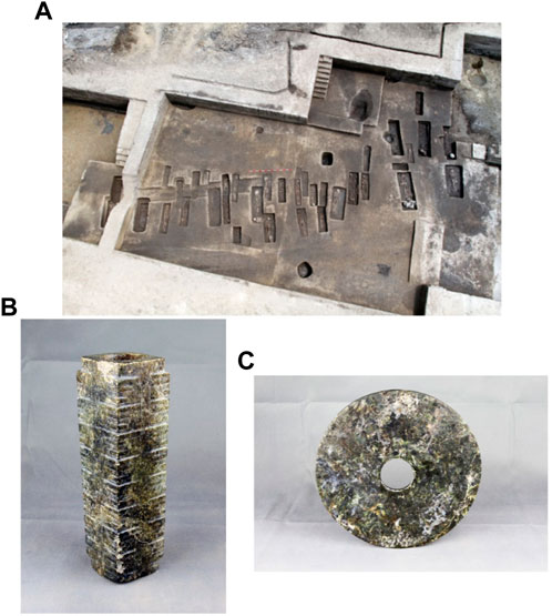
FIGURE 1. Liangzhu cultural relics at the Jiangzhuang site in Xinghua and Dongtai cities, Jiangsu Province: (A) the excavation site; (B) Excavated Cong (upper radial diameter: 6.8 cm, lower radial diameter: 6.4 cm, bore diameter: 4.6 cm, height: 23.5 cm) and (C) Bi (diameter: 24 cm, bore diameter: 5.1–5.2 cm, thickness: 1.3–1.4 cm) (A: Nanjing Museum, 2016; B and C are provided by Nanjing Museum).
With the discovery of Liangzhu cultural sites such as Jiangzhuang and Luzhuang, the opinion that “Distribution of Liangzhu culture did not cross the Yangtze River” has been gradually eroded (Wu, 1988; Li et al., 1999). It is now clear that the Liangzhu migrated north across the Yangtze River (Cui, 2011). According to the spatial distribution and cultural connotations of the sites, the unearthed artifacts, and the features of the remains, the archaeologists deduced several routes that the Liangzhu may have taken north to the Yangtze River (Figure 2). Firstly, the Zhenjiang area. There are many known Liangzhu cultural sites and remains in the Zhenjiang area, and it is believed that the ancestors of the Liangzhu may have crossed the Yangtze River north from the narrower riverway between Zhenjiang and Nanjing (Cui, 2011).Secondly, approximately 4,200 years ago, ancestors living during the late period of Liangzhu culture crossed the river from near Zhangjiagang, which was located in the north of Taihu Lake, and moved northward along the coastline at that time to settle near the Sheyang rivermouth or to migrate further north (Institute of Archaeology et al., 1996). Thirdly, the ancestors crossed the Yangtze River from the narrower riverway east of present Beijing-Hangzhou Grand Canal and migrated northward through the Jianghuai area (Luan, 1996).
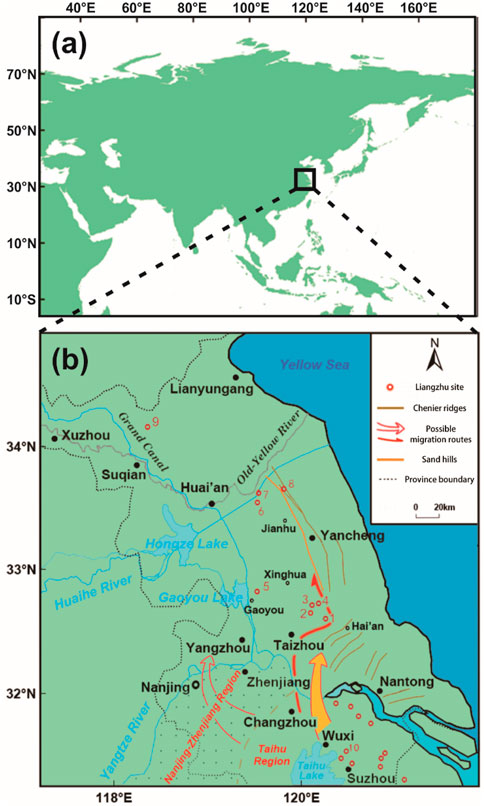
FIGURE 2. Figure showing the study area (A) and the possible route map of Liangzhu culture migrating across the Yangtze River (B) (The red circles represent: 1. Qingdun site, 2. Kaizhuang site, 3. Taozhuang site, 4. Jiangzhuang site, 5. Longqiuzhuang site, third stage, 6. Liyuan site, 7. Luzhuang site, 8. Dongyuan site, 9. Huating site, and 10. Qiuchengdun site; the three possible routes are drawn based on Cui (red hollow arrow in the west), Luan (red solid arrow in the middle) and this study (red arrow with yellow filling in the east)).
The liangzhu culture and the environment of the Yangtze River delta
During the Holocene period, the Yangtze River delta was formed by the combined flow of the Yangtze River, the Huai River and the Qiantang River, etc. flowing into the sea. The development of the delta along its north and south wings has been extensively studied, with a large number of papers being published on the subject (Wang et al., 1981; Shan et al., 1986; Yan and Xu, 1987; Liu et al., 1992; Tang et al., 1993; Chen and Stanley, 1998; Guo et al., 2013; Ding et al., 2019). It is generally accepted that the mud and silt carried by the Yangtze River were deposited in the estuary forming the Yangtze River delta. Additionally, the mud and sand brought by the Qiantang River, the Huai River, and the ancient Yellow River contributed to the formation of the south and north wings of the delta. Taihu Lake may have also been connected with the sea 7,000 years ago (Wang et al., 1981). The eastward movement of the Yangtze River estuary and the development of the south wing of the delta formed the Taihu Lake plain, with a flat terrain and a crisscrossed water network.
This favorable environment meant that the Neolithic culture series of Majiabang–Songze–Liangzhu–Qianshanyang–Guangfulin in the Taihu Basin and Hangjiahu plain was the peak period for Neolithic cultures, with abundant natural resources, thriving populations and settlements, and increased spatial distribution (Chen et al., 1997). The interactions between sea-level fluctuation and silt accumulation in the Holocene resulted in the formation of several silt dams in the north of the Yangtze approximately 7,000 years ago (Yan and Xu, 1987; Figure 3). Shallow, lagoon-like lakes gradually began to form between the silt dam to the west and Gaoyou and Hongze lakes to the east. In particular, the Lixia River area is the lowest elevation in the north of the Yangtze River in Jiangsu, with a developed water system and abundant plants and animals. These shallow lakes could have been silted up a bit and become flat land adjacent to the water where the ancient inhabitants could have settled. The geomorphologic conditions of the transition zone between land and sea provided a suitable geographical environment for external Neolithic cultures to migrate to, including the Liangzhu, who extended their range into this area north of the Yangtze. Geoscientists and environmental archaeologists have carried out in-depth studies on the early and middle Holocene anthropogenic environment in the Yangtze River delta region and have demonstrated and confirmed the formation process and the mechanism of the Neolithic cultures in the east of Jianghuai and Huanghuai and of the delta (Stanley and Chen, 1996; Chen et al., 1997; Zhu et al., 2003; Zong et al., 2007; Wang et al., 2010; Zheng et al., 2018). The area provides a scientific historical reference for the potential for people to live in harmony with the natural environment of the Yangtze River delta region in the future. However, no archaeological research has currently been conducted regarding exactly where the Liangzhu crossed the river and the migration routes.
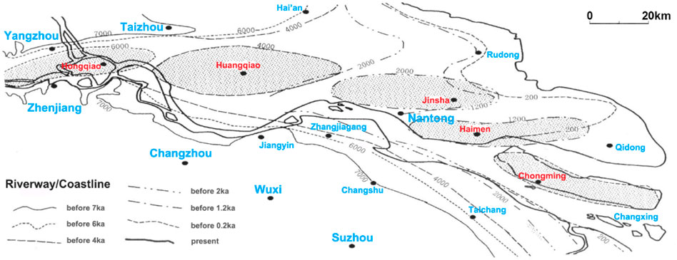
FIGURE 3. Schematic diagram of the evolution of the estuary and silt body of the Yangtze during the Holocene period. Redraw based on Cao et al., 2006.
Discussion
The Liangzhu’s migration route across the Yangtze River
The archaeological sites and remains of the Liangzhu culture to the north and south of the Yangtze have led to speculation that the Liangzhu culture initially crossed the river in the Nanjing-Zhenjiang region, and in their later period crossed near present-day Zhangjiagang before moving north along the coast, and crossed the river from the east of present-day Grand Canal. These routes and time across the river is logical from an archaeological viewpoint. The Liangzhu ruins to the south of the Yangtze are mostly distributed throughout the eastern Taihu plain (Chen, 2017). If the Yangtze River delta and the formation process of the Yangtze River channel during the Holocene are considered, the Nanjing-Zhenjiang region would not have been the ideal point for crossing the river. Near the estuary, the mud and sand were sedimented and formed the estuary bar, which contributed to the weakened river flow when the water flows into the sea.
Previous studies suggest that the development of the Yangtze River delta during the Holocene was characterized by distinct phases (Wang et al., 1981; Hori et al., 2001; Song et al., 2013). The estuary was near the Zhenjiang-Yangzhou line during the maximum sea transgression of Holocene before moving eastwards with the sediment of mud and silt carried by the river and the fluctuations of sea level. Thereafter, six river mouth bars of substages were formed around the estuary while the sedimentary center of the delta advanced toward the sea. These phases of bar formation were known as the Hongqiao phase (6500–5000 cal BP), the Huangqiao phase (6500–4000 cal BP), the Jinsha phase (4500–2000 cal BP), the Haimen phase (2500–1200 cal BP), the Chongming phase (1700–200 cal BP), and the Changxing phase (700 cal BP to the present day) (Ling, 2001). The six substage silt bars were dynamically superimposed from northwest to southeast and overlapped or linked between the adjacent two substage silt bodies. The broad seacoast channel was divided by sand bar bodies into two or more narrower branches (northern and southern). When the Yangtze River delta moved gradually eastward, the river water shifted to the south due to the Coriolis effect, and the sand in the river gradually merged into the land on the north bank. Nowadays, Hongqiao in Yangzhou, Huangqiao in Taizhou, Tongzhou (Jinsha), and Haimen in Nantong and other areas are much more likely to have been sand bars in the river during the past. At present, Chongming Island and Changxing Island, which formed over a period of 1,000 years, are still present at the mouth of the Yangtze. The northern branch of Chongming Island is gradually silting up, and the island will eventually be incorporated into the north wing and will become a spit of land.
A further simulation study found that there were two sand bodies in the wide estuary of the Yangtze River around 5250 cal BP. In around 4250 cal BP, the two sand bodies were almost connected with the land in the west, while a new channel into the sea appeared in the east. Due to the accumulation of sand bodies, most of the channels to the sea in the Yangtze River were located approximately 3 m below the water surface. The evolution of the sand bodies and channels greatly assisted the Liangzhu in crossing the river (Xie and Yuan, 2012; Figure 4).
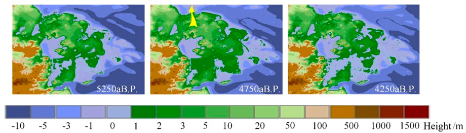
FIGURE 4. Simulation results of the evolution of the land and sea environment in the Yangtze River delta (the yellow arrow on 4750 cal BP indicates the rough migration route. Redraw based on Xie and Yuan, 2012).
The Liangzhu culture were mainly found between the Ningzhen Mountains in the west and Shanghai in the east, between the Qiantang River basin in the south, and the Huanghuai plain in the north. This region is a transitional zone between land and ocean located in the middle-low latitudes of the northern hemisphere. Because of the moderate temperature, abundant precipitation, low-lying terrain, and numerous branching streams, shallow lakes, and ponds, the area was ideal for human habitation and multiplication. Additionally, implements and tools suitable for using underwater have also been found in the area. The ancient city of Liangzhu, which was the heart of Liangzhu culture, contained a developed waterway transportation network to Taihu Lake and other areas (Wang, 2016; Zhao, 2018). Additionally, a large number of ancient dams and a relatively intact hydrological “system” have also been discovered (Zhao, 2018). An excavated canoe also proved that watercraft were used in Jiangsu and Zhejiang as early as the pre-Liangzhu culture period, probably for shipping purposes and for fishing and gathering aquatic plants.
The Xiaoshan Kuahuqiao (cross-lake bridge) site, not far from Liangzhu City, is an early-middle Neolithic site dating from 8200 to 7000 cal BP in the Qiantang River basin, Zhejiang Province (Archaeology of Zhejiang province, 2004). One of the highlights found at this site was a relatively well-preserved canoe with wooden oars, which is thought to be the earliest known Chinese canoe (Archaeology of Zhejiang province, 2004; Gong, 2012). The canoe remnant is 5.60 m long, 0.52 m wide, and 0.15 m deep (Figure 5A; 5B). It was manufactured by using an entire Masson pine, which had been burned and then chipped with an adze. It was thought to have been manufactured around 8000–7500 cal BP and the site where it was excavated was probably a “shipyard”. This discovery proves that 5 m long canoes were being made in the Qiantang River basin more than 3,000 years before the arrival of the Liangzhu. Canoes may also have been produced and used during the early Neolithic period in Jiangsu and Zhejiang. More importantly, a canoe of 7.35 m long and 0.45 m wide and 0.23 m deep, dating to about 5,000 cal aBP, was also unearthed in 2010 from the cultural layer at the Maoshan Site in Yuhang district, near Liangzhu, is by far the longest and most complete prehistoric canoe unearthed in China (Figure 5C).
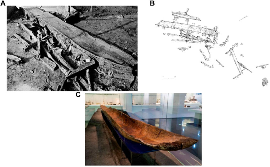
FIGURE 5. Photograph of unearthed canoe remnant (A) Zhejiang Provincial Institute of Cultural Relics and Archaeology, Xiaoshan Museum, 2004) and its planned distribution (B) Wu, 2012); the longest and most complete canoe (C) https://www.163.com/dy/article/H8D7FJ6R05149IKJ.html).
This canoe was undoubtedly made during the Liangzhu period. In addition, dock facilities were excavated in Bianjiashan and Mojiaoshan near Liangzhu City. Several wooden oars were also found. Along with those found at the Kuahuqiao and the Hemudu sites (Gong, 2012), which predated the Liangzhu, wooden oars have been unearthed at Liangzhu sites including Bianjiashan, Mojiaoshan, Shuitianpan in Hangzhou, Qianshanyang in Wuxing, and Shahe in Liyang, implying that “the inhabitants of the Liangzhu culture were good at using boats” (Institute of Archaeology et al., 1996; Wang, 2016).
Whether it was very difficult to cross the Yangtze River in a canoe and need to using paddles or oars? During the crossing-Yangtze River-campaign between the army of the Kuomintang (KMT) and the Communist Party (CPC) in 1949, three companies (300–400 men) of the People’s Liberation Army (PLA, the army led by the CPC) crossed the river on the night of 21 April 1949, from the north bank of Yangtze River to Shuangshan island with wooden boats of 10–30 tons, with sails and manual oars, and loaded with soldiers, weapons and ammunition. The distance between north bank to Shuangshan island is about 3 km (Party’s History and Local History Office of Zhangjiagang Municipal Committee, CPC. 2005). About 30 min later, the first troops reached Shuangshan island, then the wooden ships returned and continued to transport troops and weapons to Shuangshan Island. At dawn on April 22, the PLA captured the Shuangshan island, then crossed the river from Shuangshan island and took over Shazhou (now administrated by Zhangjiagang City) in the daytime of April 22. In addition, before the civil war between KMT and CPC armies in 1949, the CPC had established a secret communication line in the south and north of Zhangjiagang, relying on small fishing boats to transfer military information and secret workers across the Yangtze River, relying on the “one leaf boat”. Judging from the photos taken at that time, the boat was no more than 10 m long and 1.8 m wide, and the power was only one or two paddles or oars. Several PLA military leaders were transported from the north of the Yangtze River to the south even with such small boats. These evidences are now stored in Jiangsu Zhangjiagang City Shuangshan Island River Crossing Campaign exhibition Hall, Suzhou Revolutionary Museum and other places. Similarly, in the Anhui section of the Crossing-Yangtze-River Campaign between KMT and CPC in April 1949, the boats carrying the PLA across the Yangtze River was more than 8 m long, carrying 18 soldiers and two boatmen (Zhang, 2020). From the course of the PLA’s crossing campaign in April 1949, it can be proved that the Liangzhu ancestors could travel back and forth between the Yangtze River by canoes in a relatively short period of time (within 5–6 h) in calm and tranquil weather.
According to the building history of the ancient canoes in the Jiangsu-Zhejiang area and the Taihu plain, and the wooden oars found at several Liangzhu sites, the Liangzhu first crossed the south branch of the Yangtze River ancient riverway via the Changzhou - Jiangyin - Zhangjiagang line north of Taihu Lake by using canoes and arrived at estuarine sandbars during the Huangqiao period (or early Jinsha period), then crossed the Yangtze River north branch and arrived in the north side of the Yangtze River. Regarding the several river routes determined by archaeological research, there is a suspicion of go far afield that the Liangzhu favored the Nanjing-Zhenjiang route to cross the Yangtze River. It has also been shown that the Liangzhu crossed the Yangtze from Zhangjiagang throughout the entire cultural period, not only occurred in the late period. Additionally, they can reach the north bank directly and then migrate northward.
Combined with historical documents, archaeological research also holds that it is feasible for Liangzhu ancestors to cross the river near the rivermouth by rowing north along the seawall (Luan, 1996). Theoretically, it is possible to sail north along the seawall with small boats, taking into account factors such as the coastline, coastal landforms, coastal currents and tidal currents around 5,000 years ago. But if a large estuary had a surge similar to the current Qiantang River estuary, it would be more difficult to travel north by using small boats.
We has studied the period of land-forming in the east area of Jianghuai north of the Yangtze River (Xiao et al., 2023). At about 5800cal aBP, the area south of the ancient Huai River, east of the Beijing-Hangzhou Canal, north of the Yangtze River, east to Xigang (Figure 2B) was already continental. Due to the formation of the Gangxi sand hills, it becomes the boundary between sea and land. The west side of Gangxi is a shallow lake swamp environment with lagoon and dense water network and provided a new living space for Liangzhu culture to move north and north Neolithic culture to move south.
The ancient fauna founded in Longqiuzhuang site are mainly represented by animals that like warm and wet environment, such as elk, swertia and freshwater fishes, mussels, etc., which implied the developed fishing and hunting economy. Fishing and hunting, livestock and rice cultivation were the means for the ancestors of Longqiuzhuang to survive (The Archaeological Team of Longqiuzhuang, 1999). Among the plants unearthed from Jiangzhuang site, the remains were rice, Euryale Salisb, water chestnut, Nymphoides, Potamogetonaceae, etc. and the bones unearthed were aquatic animals such as fish, turtles and terrestral animals such as the most common Cervidae, followed by pigs, dogs, water buffalo, etc. (Nanjing Museum. 2016).
The archaeological researches have confirmed that the water network of shallow freshwater lakes and swamps in the eastern Jianghuai could provide rich food resources for the ancestors of Liangzhu. Based on the study of palaeogeography and archaeology, it can be concluded that Liangzhu ancestors crossed the Yangtze River in Changzhou–Jiangyin - Zhangjiagang, then directly crossed the dike of the Yangtze River and sailed north or east and west along the water network with small boats. The shallow marsh provided abundant food, which was convenient for Liangzhu ancestors to settle down and develop in a suitable place after crossing the river. In addition, according to common sense, an ordinary being who grew up on land must have 10–20 years of sea training to get used to the physical effects of seasickness, and has little physical capacity during seasickness. But there is no risk of seasickness on land. Since the Liangzhu ancestors could sail on land and water in the east Jianghuai, there was no need to sail north outside the sea in the stormy environment.
Conclusion
The more in-depth archaeological studies are conducted, the more the consensus confirms that the Liangzhu culture of the Yangtze River delta originated to the south of the Taihu plain. However, in the late 1980s, the prevailing viewpoint (Song et al., 2013) that the Liangzhu culture remained south of the Yangtze was disproved by subsequent archaeological studies, as the discovery of many relics of the Liangzhu culture, with large-scale, rich cultural connotations, were found to the north of the river, particularly around its eastern reaches and around the Huaihe River. After considering the development of the Yangtze River delta during the Holocene period, and the ancient canoes, wooden oars, and docks, which have been unearthed by archaeological digs, it is entirely feasible that the Liangzhu arrived at the sand bar in the center of the Yangtze River after crossing its south branch along the Changzhou–Jiangyin–Zhangjiagang line, before migrating to the northern bank after moving across its northern branch. The Nanjing-Zhenjiang line was the likely route for Liangzhu ancestors west of Taihu Lake to cross the Yangtze River, but it should not be the main route for Liangzhu culture to cross the Yangtze River. Sailing north across the Yangtze River along the dike is much more difficult at sea than at the land-based water network. But it should be a feasible route for Liangzhu ancestors migrating northward along the west side of the sand hills (see details in Figure 2B). According to the dating results of unearthed canoe and wooden oars, as well as the evolution of the Yangtze riverways and deltas throughout the Holocene period, and other supporting studies of archaeology and paleogeography, the formation and evolution of the sand bar at the estuary during the Huangqiao period (before 4000 cal BP) met the geographical conditions for ancient ancestors to cross the river in the early Liangzhu period. During the whole Liangzhu period, the area between Changzhou - Jiangyin - Zhangjiagang should be the best place to cross the river. Further archaeological studies need to be conducted to determine whether earlier cultures before Liangzhu to cross the Yangtze River (Cao et al., 2006).
Data availability statement
The original contributions presented in the study are included in the article/supplementary material, further inquiries can be directed to the corresponding author.
Author contributions
JX: Conceptualization, Funding acquisition, Investigation, Methodology, Resources, Validation. ZS (corresponding author): Project administration, Visualization, Writing–original draft and review & editing. ZZ: Visualization, Writing–review & editing. SX: Site Investigation, Revision. XJ: Funding acquisition, Supervision. All authors have read and agreed to the published version of the manuscript.
Funding
This work was jointly supported by the National Natural Science Foundation of China (Grant No. 41472141, 42271163) and was funded by the Priority Academic Program Development of Jiangsu Higher Education Institutions (PAPD) and the Innovation Team at Nanjing Normal University.
Conflict of interest
The authors declare that the research was conducted in the absence of any commercial or financial relationships that could be construed as a potential conflict of interest.
The handling editor HFL declared a past co-authorship with the author XJ.
Publisher’s note
All claims expressed in this article are solely those of the authors and do not necessarily represent those of their affiliated organizations, or those of the publisher, the editors and the reviewers. Any product that may be evaluated in this article, or claim that may be made by its manufacturer, is not guaranteed or endorsed by the publisher.
References
Cao, G. J., Wang, J., and Qu, G. X. (2006). Channel evolution of the Yangtze River estuary section since Holocene. Yangtze River 37 (2), 25–27, 36. doi:10.16232/j.cnki.1001-4179.2006.02.010
Chen, T. (2017). “Mid-to late Holocene hydrology changes in the south Taihu area of the Yangtze delta plain, China, and its relationship to the development of Neolithic culture,” (Shanghai, China: East China Normal University), 16–19. Doctoral Dissertation.
Chen, Z., and Stanley, D. J. (1998). Sea-level rise on eastern China’s Yangtze Delta. J. Coast. Res. 14 (1), 360–366.
Chen, Z. Y., Hong, X. Q., Li, S., Wang, L., and Shi, X. M. (1997). Study of archaeology-related environment evolution of Taihu lake in southern Changjiang Delta plain. Acta Geogr. Sin. 52 (2), 131–137. doi:10.11821/xb199702005
Chen, Z. Y., Zong, Y. Q., Wang, Z. H., Wang, H., and Chen, J. (2008). Migration patterns of neolithic settlements on the abandoned yellow and Yangtze River deltas of China. Quat. Res. 70, 301–314. doi:10.1016/j.yqres.2008.03.011
Cui, Y. J. (2011). The research on culture and society in the prehistoric eastern jiang-huai region. Shandong Univ. Dr. Diss. 29 (45), 63–65.
Ding, D. L., Zhang, X. H., Yu, J. J., Wang, L. Y., Wang, F., and Shang, S. W. (2019). Sediment grain size distribution patterns of the late Quaternary on the back side of the northern Yangtze River Delta and their environmental implications. Mar. Geol. Quat. Geol. 39 (4), 34–45. doi:10.16562/j.cnki.0256-1492.2019022801
Gong, C. Q. (2012). “Canoe in pictures[A]. Kuahuqiao site Museum of xiaoshan, Hangzhou,” in Proceedings of the International Symposium on Kuahuqiao Culture (Beijing: Cultural Relics Publishing House), 158–168.
Guo, S. Q., Ma, Q. B., Zhang, X. Y., Ge, Y., and Gong, X. L. (2013). Holocene environmental changes in the Lixiahe area. Geol. China 40 (1), 341–351.
Hori, K., Saito, Y., Zhao, Q., Cheng, X., Wang, P., Sato, Y., et al. (2001). Sedimentary facies and Holocene progradation rates of the Changjiang (Yangtze) delta, China. Geomorphology 41 (2-3), 233–248. doi:10.1016/S0169-555X(01)00119-2
Institute of ArchaeologyNanjing MuseumYancheng Antiquity Preservation committeeYancheng Museum (1996). The discovery of Lu Zhuang relics, the light of oriental civilization-collected essays in commemoration of 60th anniversary of the discovery of the Liangzhu culture. Yancheng, China: Yancheng Museum.
Li, C. X., Chen, Q. Q., Fan, D. D., Zhang, J. Q., and Yang, S. Y. (1999). Palaeogeography and palaeoenvironment in changjiang delta since last glaciation. J. Palaeogeogr. 1 (4), 12–25. doi:10.3969/j.issn.1671-1505.1999.04.002
Ling, S. (2001). Shoal’s merging into land and evolution of north coastline of Changjiang estuary. J. Oceanogr. Taiwan Strait 20 (4), 484–489.
Liu, K. B., Sun, S. C., and Jiang, X. H. (1992). Environmental change in the Yangtze River delta since 12000 years B.P. Quat. Res. 38 (1), 32–45. doi:10.1016/0033-5894(92)90028-H
Luan, F. S. (1996). The northward migration of Liangzhu culture. Cult. Relics Central China 3, 51–58.
Museum, Nanjing (2016). The relics of Liangzhu culture at Jiangzhuang site in Xinghua and Dongtai cities, Jiangsu province. Archaeology 7, 19–31.
Nanjing Museum, Yancheng MuseumFuning Bureau of Culture (2004). Neolithic dongyuan site in funing county, Jiangsu province. Archaeology 6, 7–21.
Party’s History and Local History Office of Zhangjiagang Municipal Committee, CPC (2005). Local history of Zhangjiagang (sandbar). CPC 1. 111.
Shan, S. M., Wang, W. P., and Wang, T. K. (1986). Jiangsu geographical. Jiangsu, China: Jiangsu People Press.
Song, B., Li, Z., Saito, Y., Okuno, J., Li, Z., Lu, A., et al. (2013). Initiation of the Changjiang (Yangtze) delta and its response to the mid-Holocene sea-level change. Palaeogeogr. Palaeoclimatol. Palaeoecol. 388, 81–97. doi:10.1016/j.palaeo.2013.07.026
Stanley, D. J., and Chen, Z. (1996). Neolithic settlement distributions as a function of sea level-controlled topography in the Yangtze Delta[J]. China. Geology (12), 1083–1086. CO;2. doi:10.1130/0091-7613(1996)024<1083:NSDAAF>2.3
Sun, L., and Gao, M. H. (2006). An archeogeographical study on the changes of Jiangnan coastline. Southeast Culture 4, 11–17.
Tang, L. Y., Shen, C. M., Zhao, X. T., Xiao, J. Y., Yu, G., and Han, H. Y. (1993). Vegetation and climate since 10000 BP in the qingfeng section, jianhu, Jiangsu. Sci. China (Series B) 23 (6), 637–643.
The Archaeological Team of Longqiuzhuang (1999). Neolithic site excavation report in the Eastern Part of Jiang-Huai area. Beijing, China: Science Press, 519–520.
Wang, J. M. (2015). The relationship between the pattern of Liangzhu jade and the development-decline of Liangzhu culture. Heilongjiang Chronicles 22, 54–56.
Wang, J. T., Guo, X. M., Xu, S. Y., Li, P., and Li, C. X. (1981). Evolution of the Holocene changjiang delta. Acta Geol. Sin. 1, 67–81.
Wang, N. Y. (2016). Survey and excavation of the water conservancy system in Liangzhu city and surroundings. Res. Herit. Preserv. 1 (5), 102–110.
Wang, W. M., Shu, J. W., Chen, W., and Ding, J. L. (2010). Holocene environmental changes and human impact in the Yangtze River Delta area, east China. Quat. Sci. 30 (2), 233–244. doi:10.3969/j.issn.1001-7410.2010.02.01
Wang, Z. H., and Chen, J. (2004). Distribution of the Neolithic sites in the Chang Jiang coastal plains: Holocene transgression impact. Quat. Sci. 24 (5), 537–545.
Wu, J. (2012). “Analysis and thinking of the unearthed state of a canoe at Kuahuqiao site. [A]. Kuahuqiao site Museum of Xiaoshan, Hangzhou,” in Proceedings of the International Symposium on Kuahuqiao Culture (Beijing: Cultural Relics Publishing House), 125–140.
Wu, J. M. (1988). Distribution of prehistoric sites in the Yangtze River Delta and environmental evolution. Southeast Cult. 6, 16–36.
Xiao, J., Shang, Z., Xu, J., Jia, X., and Xiao, S. (2023). The neolithic culture and paleogeographic environment evolution in the eastern Jianghuai area. Land 12, 156. doi:10.3390/land12010156
Xie, Z. R., and Yuan, L. W. (2012). Fluctuation characteristics of Holocene sea-level change and its environmental implications. Quat. Sci. 32 (6), 1065–1077. doi:10.3969/j.issn.1001-7410.2012.06.02
Yan, Q. S., and Xu, S. Y. (1987). Recent Yangtze delta deposits. Shanghai, China: East China Normal University Press, 264–271.
Yancheng MuseumDongtai Museum (2005). Neolithic Kaizhuang site in Dongtai city, Jiangsu province. Archaeology 4, 12–26.
Zhang, Y. S. (2020). The octogenarian Chen Wenyi: The heroic helmsman of the first ship crossing the Yangtze River. New Youth 10, 6–9.
Zhao, Y. (2018). Liangzhu: The paradigm of early civilization in China. South. Cult. relics 1, 69–76.
Zhejiang Provincial Institute of Cultural Relics and ArchaeologyXiaoshan Museum (2004).Kua Hu Qiao. London, UK: Cultural Relics Publishing House, 222–228.
Zheng, H. B., Zhou, Y. S., Yang, Q., Hu, Z. J., Ling, G. J., Zhang, J. Z., et al. (2018). Spatial and temporal distribution of Neolithic sites in coastal China: Sea level changes, geomorphic evolution, and human adaption. Sci. China Earth Sci. 61, 123–133. doi:10.1007/s11430-017-9121-y
Zheng, Y. F. (2018). The social livelihood pattern and rice cultivation in the Liangzhu culture period. Cult. Relics South. China 1, 93–101.
Zhu, C., Zheng, C. G., Ma, C. M., Yang, X., Gao, X., Wang, H., et al. (2003). On the Holocene sea-level highstand along the Yangtze delta and ningshao plain, east China. Chin. Sci. Bull. 48 (24), 2672–2683. doi:10.1007/BF02901755
Keywords: Liangzhu culture, Liangzhu ancestors migrating across Yangtze River, Yangtze River delta, early-middle Holocene, river-mouth sandbar, ancient canoe
Citation: Xiao J, Shang Z, Zhang Z, Xiao S and Jia X (2023) A preliminary study on the mechanism of the Liangzhu culture’s migration across the Yangtze river. Front. Earth Sci. 11:1121469. doi: 10.3389/feart.2023.1121469
Received: 11 December 2022; Accepted: 10 January 2023;
Published: 20 January 2023.
Edited by:
Harry F. Lee, The Chinese University of Hong Kong, ChinaReviewed by:
Yan Liu, East China Normal University, ChinaJunwu Shu, Nanjing Institute of Geology and Paleontology (CAS), China
Copyright © 2023 Xiao, Shang, Zhang, Xiao and Jia. This is an open-access article distributed under the terms of the Creative Commons Attribution License (CC BY). The use, distribution or reproduction in other forums is permitted, provided the original author(s) and the copyright owner(s) are credited and that the original publication in this journal is cited, in accordance with accepted academic practice. No use, distribution or reproduction is permitted which does not comply with these terms.
*Correspondence: Zhiyuan Shang, c2hhbmd6eUBuam51LmVkdS5jbg==