 Yifan Hu1
 Guojie Wang1*
 Xikun Wei1Feihong Zhou1
 Giri Kattel1,2,3†
 Solomon Obiri Yeboah Amankwah1
 Daniel Fiifi Tawia Hagan1
 Zheng Duan4
- 1Collaborative Innovation Center on Forecast and Evaluation of Metcorological Disasters, Nanjing University of Information Science and Technology, Nanjing, China
- 2Department of Infrastructure Engineering, The University of Melbourne, Melbourne, VIC, Australia
- 3Department of Hydraulic Engineering, Tsinghua University, Beijing, China
- 4Department of Physical Geography and Ecosystem Science, Lund University, Lund, Sweden
Soil moisture is an essential component for the planetary balance between land surface water and energy. Obtaining long-term global soil moisture data is important for understanding the water cycle changes in the warming climate. To date several satellite soil moisture products are being developed with varying retrieval algorithms, however with considerable missing values. To resolve the data gaps, here we have constructed two global satellite soil moisture products, i.e., the CCI (Climate Change Initiative soil moisture, 1989–2021; CCIori hereafter) and the CM (Correlation Merging soil moisture, 2006–2019; CMori hereafter) products separately using a Convolutional Neural Network (CNN) with autoencoding approach, which considers soil moisture variability in both time and space. The reconstructed datasets, namely CCIrec and CMrec, are cross-evaluated with artificial missing values, and further againt in-situ observations from 12 networks including 485 stations globally, with multiple error metrics of correlation coefficients (R), bias, root mean square errors (RMSE) and unbiased root mean square error (ubRMSE) respectively. The cross-validation results show that the reconstructed missing values have high R (0.987 and 0.974, respectively) and low RMSE (0.015 and 0.032 m3/m3, respectively) with the original ones. The in-situ validation shows that the global mean R between CCIrec (CCIori) and in-situ observations is 0.590 (0.581), RMSE is 0.093 (0.093) m3/m3, ubRMSE is 0.059 (0.058) m3/m3, bias is 0.032 (0.037) m3/m3 respectively; CMrec (CMori) shows quite similar results. The added value of this study is to provide long-term gap-free satellite soil moisture products globally, which helps studies in the fields of hydrology, meteorology, ecology and climate sciences.
1 Introduction
Soil moisture is one of the most important variables affecting hydrological and climatic processes by affecting the exchanges of water and energy between the Earth’s surface and the atmosphere (Schwingshackl et al., 2017). Soil moisture can influence the short-term weather and long-term climatic processes by altering the physical, chemical, and biological interactions at land-atmosphere interface (Jung et al., 2010; Mittelbach et al., 2012; Yang et al., 2016; Sang et al., 2021). Being the major actor of vegetation photosynthesis, soil moisture affects the carbon cycle processes of land surface (Seneviratne et al., 2010). It can also change the surface albedo and soil thermal properties, consequently affecting the boundary layer properties, such as cloud, precipitation, and evapotranspiration (Ma et al., 1999; Cook et al., 2006; Guan et al., 2009).
Soil moisture has been widely investigated to understand drought variability (Zhang et al., 2021a; Liu et al., 2021; Lu et al., 2021), flood episodes (Wasko and Nathan, 2019; Eeckman et al., 2020), crop yields (Rossato et al., 2017; Champagne et al., 2019), and forest fires (Rigden et al., 2020; Thomas Ambadan et al., 2020). However, studies have indicated significant soil moisture variability over time and space due to climate, biology, soil properties, topography, and human activities such as cultivation, fertilization, irrigation and consequently new soil-formation (Korres et al., 2015). Therefore, it is of great significance to obtain accurate soil moisture variations at local, regional and global scales for many related hydrological, meteorological and ecological applications.
Soil moisture data can be obtained from model simulations, site measurements and satellite observations (Wang et al., 2019). The model simulation often has strong uncertainty in accuracy, which mostly relies on the land surface models to simulate the soil moisture processes (Hu and Lv, 2015; Raoult et al., 2018). Observational soil moisture is more reliable and can assist correcting biases or evaluating the model simulated data (Huang et al., 2008; Yang et al., 2021). Generally, the in-situ measurement outperforms satellite observations with higher accuracy, less affected by atmospheric and vegetation conditions (Zhu et al., 2017). However, the site observations have sparse distribution and are heavily limited by manpower and other resources, which thus cannot well capture the soil moisture variability of large spatial scales (Crow et al., 2012). Presently, the satellite remote sensing technology has become the most effective tool for large-scale soil moisture monitoring (Zeng et al., 2015). Compared with in-situ measurements, satellite-based observations can capture the soil moisture variability at regional and global scales with lower costs (Yee et al., 2017). The microwave remote sensing has the advantages of all-weather observation, making it a promising approach for retrieving soil moisture of land surface (Stamenkovic et al., 2017). Nevertheless, the satellite service life limits the temporal coverage of soil moisture products (Karthikeyan et al., 2017). Meanwhile, there are considerable data gaps in satellite soil moisture products due to scan width, dense vegetation, atmospheric conditions, and also sensor failures, etc. (Draper, 2018). There are also different qualities among these products due to the used sensors and retrieval algorithms (Kim et al., 2015a). Some studies have used data merging technology make long-term soil moisture retrievals from different satellites, but there are still considerable data gaps in the merged products (Liu et al., 2009; Liu et al., 2012; Wagner et al., 2012; Kim et al., 2015b).
It is necessary to reconstruct the data gaps in satellite Earth observations, and there are several such studies on hydrological and meteorological variables (Long et al., 2014; Alvera-Azcárate et al., 2016; Liu et al., 2017; Cui et al., 2020; Sun et al., 2020). For instance, Wang et al. (2012) used a three-dimensional discrete cosine transform (DCT-PLS) approach to fill the data gaps in satellite soil moisture product (Wang et al., 2012); and Jing et al. (2018) used a random forest (RF) model to estimate the missing soil moisture values. Methods such as general regression neural network (GRNN) and generalized linear model are also tested in the Tibet Plateau (Cui et al., 2019) and the Midwestern United States (Llamas et al., 2020). Generally, good performances can be achieved when it is a regional study with relatively a small portion of missing values in the original data. However, there are still challenges to effectively reconstruct the missing values in large scale satellite products especially at global scales (Guevara et al., 2021).
With the rapid increase of the data amount and computing capacity, studies have tried to use the deep learning technology for reconstructing Earth observations (Ma et al., 2019), which can efficiently learn the spatio-temporal features and resolve the non-linear relationships among the data (Nogueira et al., 2018). Although the deep learning approach is believed to have significant advantages, it is mainly applied to reconstruct soil moisture, land or sea surface temperature with coarse resolution and regional scales. For instance, Fang et al. (2017) used a Long-Short-Term-Memory network to reconstruct soil moisture of United States; Wu et al. (2019) used a multi-scale feature connected convolutional neural network to reconstruct land surface temperature of Europe and Eastern China; Barth et al. (2020) used a Data INterpolating Convolutional network to reconstruct sea surface temperature with lower error and higher variability. Although there are several deep learning approaches to fill the data gaps in Earth observations, limited work is done to reconstruct long-term global soil moisture from satellites (Zhang et al., 2021b).
In this study, we have adopted a convolutional neural network (CNN) with autoencoding approach to reconstruct two soil moisture retrievals from satellites for the sake of long-term gap-free daily products. For this, a large database of in-situ global soil moisture measurements from 12 networks, consisting of 485 stations totally, is used to evaluate the reconstructed products with multiple error metrics. Such gap-free global products are urgently needed by scientific researches of multi-disciplinary fields including hydrology, meteorology, ecology and climate sciences.
2 Materials and methods
2.1 Data description
In our study, two global daily soil moisture products, namely the climate change initiative soil moisture prodcut (CCIori) (Dorigo, et al., 2017; Gruber et al., 2019; Preimesberger et al., 2020) and the correlation merging soil moisture product (CMori) (Hagan et al., 2020), are used. Both datasets are daily products merged from multiple satellites and gridded at 0.25° horizontal resolution. The applied datasets have been widely validated using in-situ observations, and they are indicated to be amongst the best satellite soil moisture products with good data promising (Dorigo, et al., 2017; Gruber et al., 2019; Hagan et al., 2020; Preimesberger et al., 2020). The CCI data is combined with active and passive microwave sensors from multiple satellites. The passive microwave soil moisture data include the Scanning Multichannel Microwave Radiometer (SMMR), the Special Sensor Microwave Imager (SSM/I), the Tropical Rainfall Measuring Mission Microwave Imager (TRMM/TMI) (Owe et al., 2008), the Advanced Microwave Scanning Radiometer for the Earth Observing System (AMSR-E) (Njoku et al., 2003), the WindSat (Parinussa et al., 2011), the Soil Moisture Ocean Salinity (SMOS) (Kerr et al., 2001), the Advanced Microwave Scanning Radiometer 2 (AMSR2) (Parinussa et al., 2015), the Soil Moisture Active Passive (SMAP) (Entekhabi et al., 2010), the Global Precipitation Measurement Microwave Imager (GMP/GMI) (Hou et al., 2014) and the Fengyun-3 (FY-3) (Yang et al., 2012) respectively. We used the most recent CCI version 7.1 combined soil moisture data. The CM data is merged from six passive microwave products, including SSM/I, TRMM/TMI, AMSR-E, WindSat, AMSR2 and FY-3B satellites. The CM data is also merged using the CCI scheme with however different merging criteria. CCI merges data by minimizing the error while CM merges data by maximizing the correlation (Hagan et al., 2020). In this study, the CCI ranges from 1989 to 2021 and the CM ranges from 2006 to 2019 respectively. Spatially, we have limited both data to 60°S–60°N, owing to the frozen soil (Ran et al., 2021) and ice cover issues at high latitudes.
The percentages of missing data in CCIori and CMori are shown in Figure 1. There are high percentages of missing data in highland mountains and mid-high latitudes, mainly due to frozen soil in winter. Apparently, there are more missing values in the CMori than the CCIori data in most regions of the globe.
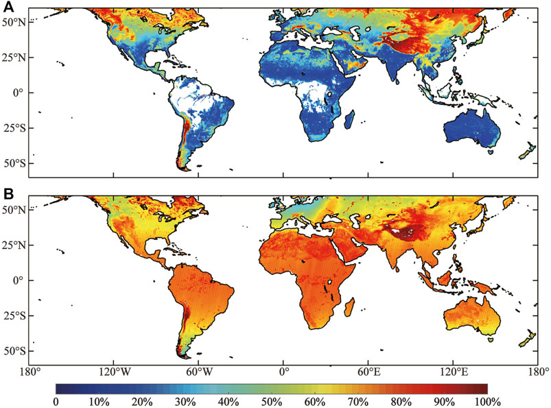
FIGURE 1. Percentages of missing values in (A) CCIori data during 1989–2021, and (B) CMori data during 2006–2019.
2.2 Data preprocessing
Due to different meteorological and terrestial conditions, the spatio-temporal soil moisture patterns are different among continents (Liu et al., 2018). We therefore partition the global land into six regions as shown in Figure 2, considering two key aspects: 1) The oceans have to be eliminated from the model training so as to minimize its impact on terrestrial soil moisture; 2) these partitions have some overlapping regions, so that the artifacts at edges can be reduced during post-processing (Barth et al., 2020).
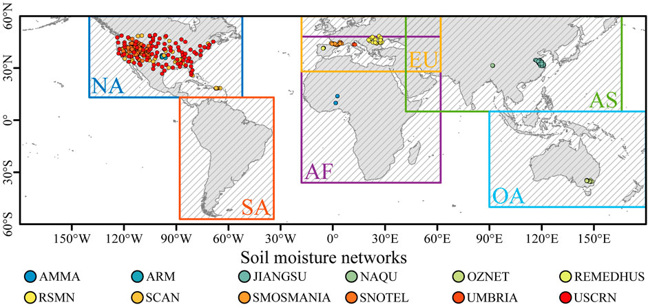
FIGURE 2. The partitioned regions for model training and the used 485 in-situ stations monitoring soil moisture. These stations are from 12 networks; JIANGSU network is from China and the other are from the ISMN project.
2.3 The deep learning (DL) model
Generally, traditional reconstruction methods can only consider temporal information for time series reconstruction or only spatial information for image reconstruction in the reconstruction process, while cannot consider both spatial and temporal information of data in the reconstruction process, which leads to a great uncertainty (Zhang et al., 2021c). It has been shown that DL methods generally outperform traditional data reconstruction methods with stronger non-linear modeling capabilities (Nogueira et al., 2018; Ma et al., 2019; Wu et al., 2019), and the CNN method is able to consider both temporal and spatial information of the data in the reconstruction process (Barth et al., 2020; Han et al., 2020; Luo et al., 2022). For the above reasons, this study does not compare the performance of different methods, but focuses on obtaining reconstructed data.
The used model here is a CNN structure with autoencoding approach. The convolutional auto-encoder replaces the full connection layer in the traditional auto-encoder with a convolutional layer and a pooling layer, thus effectively reducing data transfer loss (Yuan et al., 2019). The model contains five encoding and decoding layers, and each layer has a convolutional kernel size of 3 × 3. The pooling layer is used to reduce the size of the model, enhance computational speed, and optimize model robustness during features extraction. After each encoding layer, there is an average pooling layer with a filter size of 2 × 2; they together constitute the encoder which can convert the input feature into a latent-space representation. The decoder, consisting of convolutional layers and interpolation layers, reconstructs the input data according to the potential spatial representation obtained by the encoder. Meanwhile, skip connection structures are added to the model to increase feature utilization. The DL model obtains soil moisture values, longitude, latitude and time information from CMori and CCIori data respectively, from which the input feature is generated. The input feature includes not only soil moisture at date T, but also the values at date T − 1 and T + 1. Moreover, The seasonality calculated at date T is also added to the feature, so that the DL model can consider the seasonal variability. Longitudes and latitudes are added to the input feature, so that the DL model can consider the influence of spatial positions on soil moisture. During the network training process, the convolution operation enables the model to consider the influence of the surrounding pixels on the center pixel soil moisture. In summary, the used DL model can consider information from both spatial and temporal dimensions, which is the main advantage of the model. The model diagram is shown in Figure 3. We chose RMSE as the loss function of the model to assess the error between the predicted and true values, which also provides support for the parameter adjustment of the model (LeCun et al., 2015). The formula is as follows:
where
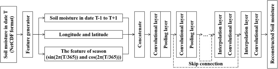
FIGURE 3. Structure of the used CNN model with autoencoding approach.
2.4 Data post-processing
The DL model is trained for the six partitioned regions respectively, from which the reconstructed data are then spatially merged with edge artifacts removed. Soil moisture is considered ineffective in densely vegetated areas; therefore we have eliminated the reconstructed values where the multiple-year averaged NDVI (Normalized Difference Vegetation Index) is higher than 0.8 using the Advanced Very High-Resolution Radiometer (AVHRR) product (doi.org/10.7289/V5PZ56R6). The reconstructed values are also eliminated where soil temperature is below 0°C in cold seasons using ERA5-Land data a reference (doi.org/10.24381/cds.e2161bac).
2.5 Data quality evaluation
We use cross-validation and in-situ observations to evaluate the quality of reconstructed data. Several error metrics including the correlation coefficient (R), bias, root mean square error (RMSE) and unbiased root mean square error (ubRMSE) are used. The formula is as follows:
where
For the cross-validation, we add 20% artificial missing values in the CCIori and CMori data respectively, and also continous missing values in rectangular regions. Then the convolutional auto-encoder is used for reconstruction. Finally, the reconstructed artificial missing values and their corresponding original values are used to evaluate the reconstruction performance. For the in-situ validation, we use the measured daily data obtained from multiple soil moisture stations in the International Soil Moisture Network (ISMN) as the in-situ data for the evaluation (Dorigo et al., 2013). Totally eleven networks are selected from ISMN, which are distributed in North America and Europe, Africa, Asia, and Oceania. An additional soil moisture network from Jiangsu province, China is also used. Finally we have twelve soil moisture networks which consist in-situ soil moisture observations, spanning 2012–2017, from 485 stations for data validation. The soil moisture networks are shown as point in Figure 2 with different colors.
3 Results
In this study, we use a convolutional neural network with autoencoding approach to reconstruct soil moisture datasets. The reconstructed data effectively fills the gaps in the original data and retains the data distribution and characteristics of the original data. We first conduct cross-validation experiments by simulating missing values to demonstrate the effectiveness of the deep learning method in reconstructing soil moisture data. Then, we use loss function, data spatial pattern, time series, and data distribution to evaluate the data reconstruction results. At the same time, we also choose the in-situ data to evaluate the accuracy of the reconstruction data. The specific results for each section are shown below.
3.1 Cross-validation results
We design an experiment of artifical missing values to prove the feasibility and effectiveness of deep learning model in reconstructing soil moisture, using data of the last year of CCIori (2021) and CMori (2019). In the experiment, we add 20% missing values in random and spatially continuous manners to the CCIori and CMori data respectively. The processed data is put into the trained deep learning model to obtain the reconstructions, denoted as CCIrec and CMrec, respectively. Figure 4 shows the CCIori and CMori with artificial missing values on 31 August 2021 and 31 August 2019 as examples, and their reconstructions. It can be seen from Figure 4 that the reconstructed artificial missing values shows quite similar spatial patterns as the original data; particularly, the artificial missing values in the rectangular regions are very well reconstructed. This indicates the used DL model is capable of reconstructing not only random missing values but also those of large regions.
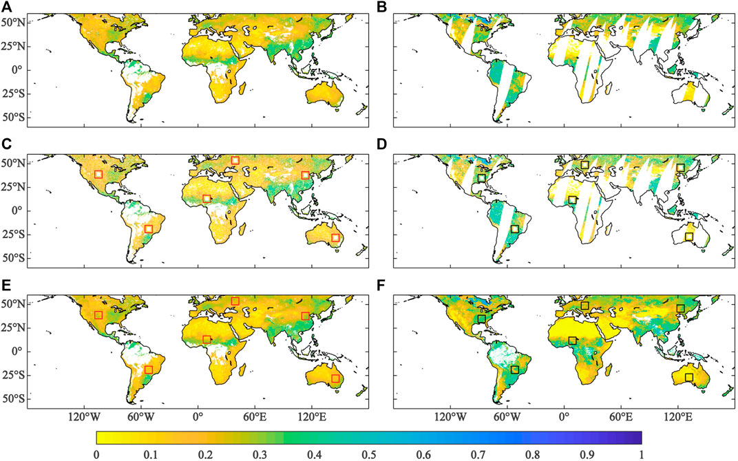
FIGURE 4. Shown in (A, B) are CCIori and CMori respectively; (C, D) are those with artificial missing values at random and in rectangular regions; CCIrec (E) CMrec (F) are their respective reconstructions (unit: m3/m3).
To better understand the reconstruction performance, we further select several small regions with artificial random and rectangular missing values to show the results as in Figure 5. Clearly, the reconstructed missing values in CCIrec and CMrec are highly consistent with those in the CCIori and CMori data. Particularly, it is found that the artificial missing values in all the rectangular regions are very well constructed with very fine spatial patterns. However, this is not surprising because the used DL model considers soil moisture variability in both spatial and temporal dimensions.
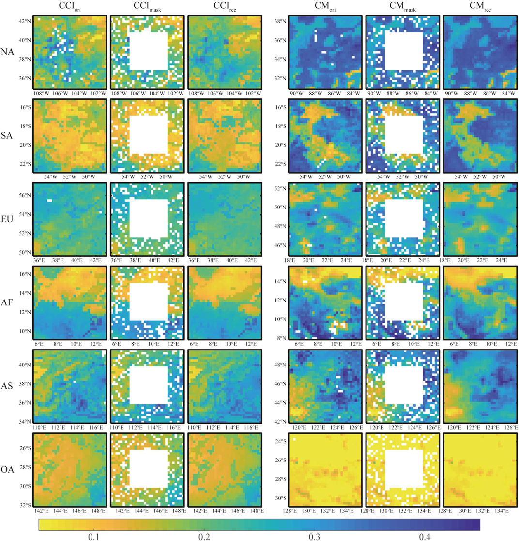
FIGURE 5. Selected regions with random and rectangular artificial missing values and their respective reconstructions (unit: m3/m3).
In addition, the scatter plots of the reconstructed artificial missing values against the original ones are shown in Figure 6. It appears clearly that the fited line (white dotted line in Figure 6) is close to 1:1 (white solid line in Figure 6), indicating the consistent density distribution between the reconstructions and original values. Meanwhile, they have high correlation coefficients and low RMSE. R for CCIori and CCIrec is 0.987 and RMSE for them is only 0.015 m3/m3. For CMori and CMrec, R is 0.974 and RMSE is 0.032 m3/m3. Obviously, R is higher for the CCI data than the CM data, and RMSE is vise versa. This is reasonable because there are apparently more missing values in the CM data which can largely affect the training of DL model. However, their differences of R and RMSE is relatively limited; this implies that the used DL model can still fulfill the reconstruction task even if there is a large portion of missing values in the original data.
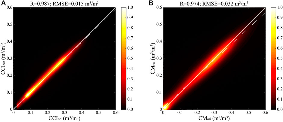
FIGURE 6. The scatter plots of artificial missing values and their reconstructions for CCI (A) and CM (B) data respectively. The colorbar indicates the data frequency.
The above results of cross-validation indicates that the used DL method is highly capable of reconstructing the missing values in the original soil moisture data, which proves that the soil moisture data reconstructed by this method has good credibility.
3.2 Loss function
To optimize parameters of the DL model, the loss function of each iteration is computed using RMSE, which is shown in Figure 7. Since the global land is partitioned into six regions (Figure 2) for the reconstruction, their loss curves are shown in Figure 7 respectively. The loss values of CCI and CM data in different regions are initially all above 0.05, which gradually decrease with increasing iterations and finally stabilize after 200 epochs. Although all the loss functions are stabilized below 0.05, they are different for the partitioned regions owing to different data properties.
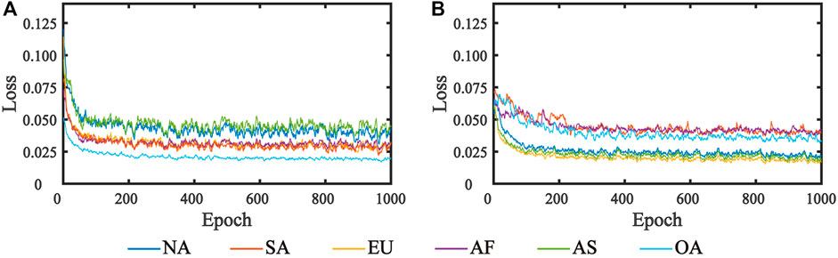
FIGURE 7. The loss function of RMSE for CCI (A) and CM (B) data. The solid lines with different colors represent the loss functions of different regions, which are consistent with each partition in Figure 2. Each epoch includes 366 iterations.
3.3 Spatial patterns
The spatial patterns of CCIori and CMori as well as their reconstructions on 1 August 2012 is used as an example to better illustrate the results. Clearly, although there are large regions of missing values in CCIori (Figure 8A) and CMori (Figure 8C), their spatial patterns are very well reconstructed as shown in Figures 8B, D respectively. It is worth noting that, values are masked out in CCIrec and CMrec where either soil temperature is below 0°C or Normalized Difference Vegetation Index (NDVI) is larger than 0.8. Clearly, both CCIrec and CMrec are rather consistent in their spatial patterns, indicating such a reconstruction with DL method can effectively resolve the data gaps in large space while preserve the spatial features of the original data.
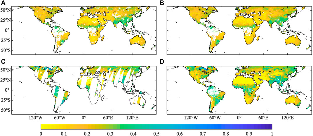
FIGURE 8. Spatial patterns of CCIori (A), CCIrec (B), CMori (C), and CMrec (D) on 1 August 2012 (unit: m3/m3).
3.4 Time series
To further verify the soil moisture reconstruction in temporal dimension, two pixels are selected to superimpose the original time series onto the reconstructed ones as shown in Figure 9. The time series spans from 1 January 2012 to 31 December 2017. While time series in Figures 9A, C are derived from the same pixel, those in Figures 9B, D are derived from a second one. It appears that, the temporal changes of original data are well reconstructed considering the variations at seasonal and finer time scales, although they are slightly different in CCI and CM data. It can be seen that, CCI data has smaller day-to-day variations than those in CM data. It is thus indicated the used DL method can reliably reconstruct the temporal variations of both CCI and CM data in presence of considerable portion of missing values.
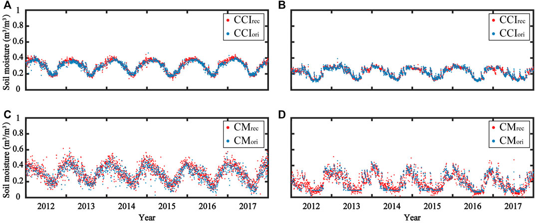
FIGURE 9. Time series from CCIori and CMori and their reconstructions. Shown in (A, C) are from the same pixel, so are those in (B, D).
3.5 Global performance
The above analysis indicates the reconstructed data retains the features of the original data in both spatial and temporal dimensions (Figures 8, 9). To understand the general performance of data reconstruction, we show the scatter plots of the global reconstructions against the original data and in-situ observations in Figure 10. The fitted data is quite close to 1:1 line (white solid line in Figure 10), and the points are almost evenly distributed on both sides of the fitted line. It appears R between CCIrec and CCIori is 0.97, and RMSE is 0.019 m3/m3 (Figure 10A); those metrics for CMrec and CMori is 0.96 and 0.031 m3/m3 (Figure 10B) respectively. It is indicated the CCI reconstruction performs better than CM data. The validations of CCIrec and CMrec with in-situ observations (Figures 10C, D) are similar to in-situ observation verification results for CCIori and CMori (Figures 10E, F). The data in Figures 10C, D are all distributed above the 1:1 line (white solid line in Figure 10), which may indicate that the CCIrec and CMrec data overestimate soil moisture to some extent. The data distribution of CCIrec is more concentrated than CMrec. R between CMrec and in-situ observations is 0.45 and 0.140 m3/m3 (Figure 10D), and those metrics for CCIrec and in-situ observations is 0.61 and 0.099 m3/m3 (Figure 10C) respectively, indicating better reconstruction results of CCI than CM.
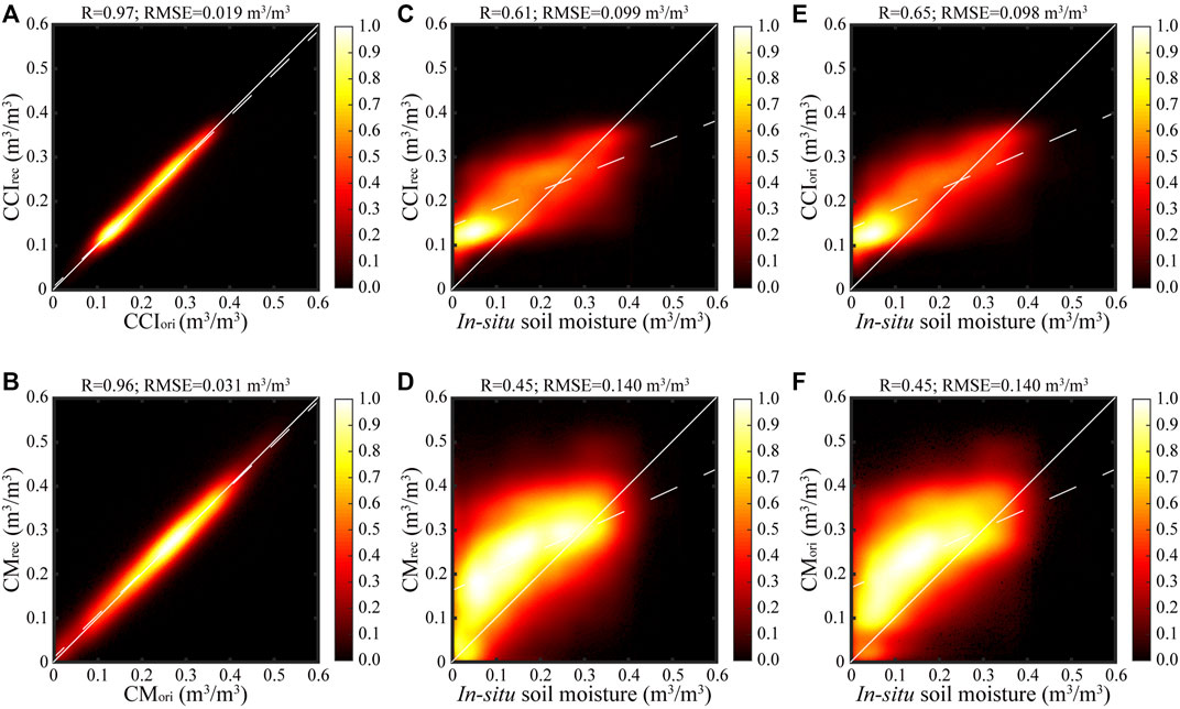
FIGURE 10. CCIrec against CCIori (A), CMrec against CMori (B), CCIori against in-situ observations (C), CMori against in-situ observations (D), CCIrec against in-situ observations (E), and CMrec against in-situ observations (F) from January 2012 to December 2017.
3.6 Comparison with in-situ observations
Four metrics of R, RMSE, ubRMSE and bias are used to further evaluate CCIrec and CMrec using global in-situ observations (Figure 11). Generally speaking, R between CCIrec and in-situ observations appears to be 0.65 on average, and that for CMrec is 0.42 on average. Apparently, CCIrec shows much higher correlations with in-situ observations with smaller range among the stations. Conversely, RMSE, ubRMSE and bias of CCIrec is much smaller than those of CMrec, and their ranges are much smaller indicating less uncertainties of these results. It is thus convincing that the derived CCIrec is more consistent with the in-situ observations globally.
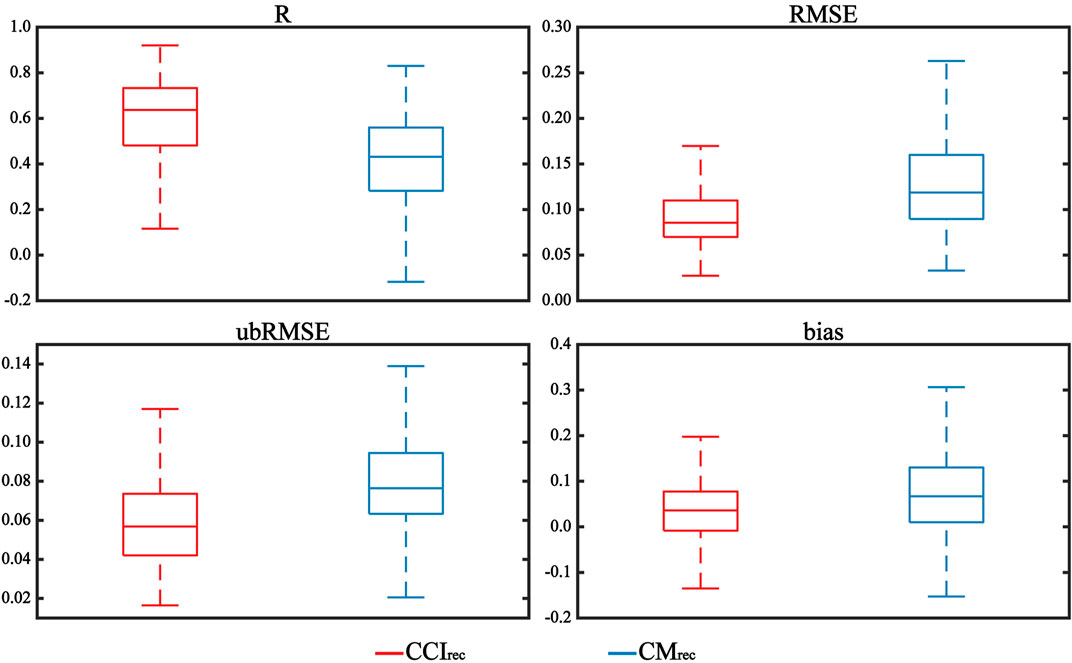
FIGURE 11. Boxplots of R, RMSE, ubRMSE and bias of CCIrec and CMrec evaluated with in-situ observations from the global International Soil Moisture Network (ISMN).
In Figure 12, we further show the boxplots of R, RMSE, ubRMSE and bias of CCIrec and CMrec against in-situ observations from eleven regional soil moisture from ISMN and the JIANGSU network in addition. Metrics of satellite data show considerable variations in different regions due to the factors such as satellite sensors, retrieval algorithms and merging algorithms (Fu et al., 2019). Apparently, R coefficients between CCIrec and in-situ observations in all the twelve regions appears to be much higher than those for CMrec; on the contrary, metrics of RMSE, ubRMSE and bias for CCIrec are largely smaller than those for CMrec. It is thus indicated that CCIrec notably outperforms CMrec in the studied soil moisture networks across the globe.
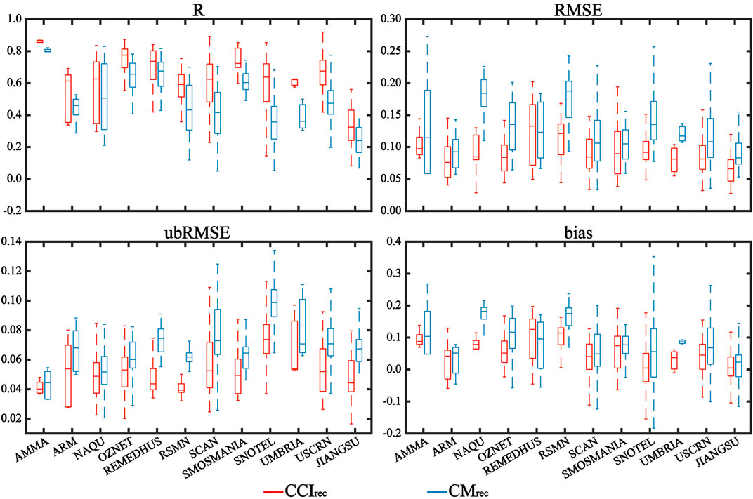
FIGURE 12. Boxplots of R, RMSE, ubRMSE and bias of CCIrec and CMrec evaluated with in-situ observations from twelve soil moisture networks across the globe.
3.7 Spatio-temporal consistency
It is of interest to understand the spatio-temporal consistency of the reconstructed CCIrec and CMrec data, for which we computed their pixel-wise correlation coefficients as shown in Figure 13. Generally, CCIrec and CMrec are highly and positively correlated across most of the global land, and their correlation coefficients can reach >0.8 in transitional regions between wet and dry climate. However, in some regions such as southwest China, they show slightly negative correlation coefficients, indicating large discrepancy in both data and we have to use them with caution. In densely vegetated regions such as rainforest, the CCIrec and CMrec values are masked out since microwave remote sensing can not penetrate dense vegetation.
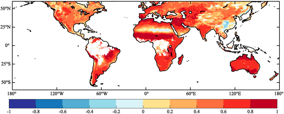
FIGURE 13. Pixel-wise correlation coefficients between CCIrec with CMrec using data of their overlapping period.
4 Conclusion and discussion
The added value of this study is generating of the longest global gap-free soil moisture records from satellites with daily resolution, which is urgently needed in Earth sciences. In this study, the DL method with auto-encoder as the main structure can fully consider the spatio-temporal information of the data itself to effectively reconstruct the satellite-based soil moisture data with missing values. The reconstructed datasets are cross-evaluated with artificial missing values, and further againt in-situ observations with multiple error metrics. The main results of this study are as follows: 1) Cross-validation has shown that the DL method used in this study has high reliability in reconstructing the missing values in satellite soil moisture products. 2) The reconstructed data can well retain the pattern of the original data in both space and time dimensions. 3) In-situ validations have shown that CCIrec is much better than CMrec. In general, the long-term global gap-free soil moisture data reconstructed in this study can provide credible support for the development of related research.
The contribution of this study is to effectively solve the problem of missing values in long-term satellite-based soil moisture products. At present, the reconstructed CCIrec is the longest gap-free soil moisture data under the premise of daily resolution, which is expected to contribute to water cycle studies in the warming climate. Most of the reconstruction work use single satellite-based soil moisture data for reconstruction (Fang et al., 2017; Zhang et al., 2021c), limited by the service life of the satellite, these data time coverage is short, difficult to obtain long-term reconstruction data. Compared with reconstruction work based on similar satellite merging soil moisture data (Zhang et al., 2021b; Guevara et al., 2021), our reconstructed data have larger spatial scale and higher temporal resolution. At the same time, compared with the global reconstruction work, we partition the global land into six regions for reconstruction, because the local model can better learn regional differences and help improve training efficiency compared with the global-scale model using global data (Chen et al., 2021). In this study, we find that the reconstructed data has a consistency with original data; but in comparison with the in-situ data, the accuracy evaluation index of the reconstructed data are slightly lower than or the same as those of the original data. Because only the soil moisture information is used for reconstruction, so that the accuracy of the reconstructed data is difficult to exceed the accuracy of the original data. This result is consistent with the research results of Zhang et al. (2021c). Barth et al. (2022) pointed out in the latest research that using more variables that are strongly associated with the reconstructed data as input to the data reconstruction process can improve the reconstruction effect to some extent. In future studies, researchers can add more variables closely related to soil moisture as CNN method inputs, such as precipitation, temperature and evapotranspiration, in the process of reconstructing soil moisture to try to improve the reconstruction results of soil moisture.
The main disadvantage of the method used in this study is that although temporal information is considered to some extent in the reconstruction process, it still has some limitations, i.e., when reconstructing soil moisture data at date T, only the effects of date T + 1 and T − 1 can be considered, while it is difficult to consider the effects of more distant dates on the reconstruction of soil moisture data at date T. At the same time, the present method does not assign different weights according to the distance from date T. Therefore, it results in the same intensity of impact on the date T data reconstruction for dates that are farther away from date T or for dates that are closer. In future research, researchers can try to introduce recurrent neural network modules into the CNN method as a way to achieve the purpose of considering the influence of more distant dates on the reconstructed date T and assigning different weights according to the distance from the reconstructed date T during the reconstruction process.
Data availability statement
The datasets presented in this study can be found in online repositories. The names of the repository/repositories and accession number(s) can be found below: http://dx.doi.org/10.11888/Terre.tpdc.272994.
Author contributions
GW design the study. YH write the paper. XW, FZ, GK, SA, DH, and ZD review the paper.
Funding
This study is financially supported by the National Natural Science Foundation of China (42275028).
Acknowledgments
We thank the researchers or teams who provided the basic data. We also thank the authors, reviewers, and editors who made amendments to the article.
Conflict of interest
The authors declare that the research was conducted in the absence of any commercial or financial relationships that could be construed as a potential conflict of interest.
Publisher’s note
All claims expressed in this article are solely those of the authors and do not necessarily represent those of their affiliated organizations, or those of the publisher, the editors and the reviewers. Any product that may be evaluated in this article, or claim that may be made by its manufacturer, is not guaranteed or endorsed by the publisher.
References
Alvera-Azcárate, A., Barth, A., Parard, G., and Beckers, J. M. (2016). Analysis of SMOS sea surface salinity data using DINEOF. Remote Sens. Environ. 180, 137–145. doi:10.1016/j.rse.2016.02.044
Barth, A., Alvera-Azcárate, A., Licer, M., and Beckers, J. M. (2020). Dincae 1.0: A convolutional neural network with error estimates to reconstruct sea surface temperature satellite observations. Geosci. Model. Dev. 13 (3), 1609–1622. doi:10.5194/gmd-13-1609-2020
Barth, A., Alvera-Azcárate, A., Troupin, C., and Beckers, J. M. (2022). Dincae 2.0: Multivariate convolutional neural network with error estimates to reconstruct sea surface temperature satellite and altimetry observations. Geosci. Model. Dev. 15 (5), 2183–2196. doi:10.5194/gmd-15-2183-2022
Champagne, C., White, J., Berg, A., Belair, S., and Carrera, M. (2019). Impact of soil moisture data characteristics on the sensitivity to crop yields under drought and excess moisture conditions. Remote Sens. 11 (4), 372. doi:10.3390/rs11040372
Chen, Y., Feng, X., and Fu, B. (2021). An improved global remote-sensing-based surface soil moisture (RSSSM) dataset covering 2003–2018. Earth Syst. Sci. Data 13 (1), 1–31. doi:10.5194/essd-13-1-2021
Cook, B. I., Bonan, G. B., and Levis, S. (2006). Soil moisture feedbacks to precipitation in southern Africa. J. Clim. 19 (17), 4198–4206. doi:10.1175/jcli3856.1
Crow, W. T., Berg, A. A., Cosh, M. H., Loew, A., Mohanty, B. P., Panciera, R., et al. (2012). Upscaling sparse ground-based soil moisture observations for the validation of coarse-resolution satellite soil moisture products. Rev. Geophys. 50 (2). doi:10.1029/2011rg000372
Cui, Y., Zeng, C., Zhou, J., Xie, H., Wan, W., Hu, L., et al. (2019). A spatio-temporal continuous soil moisture dataset over the Tibet Plateau from 2002 to 2015. Sci. Data 6 (1), 247–7. doi:10.1038/s41597-019-0228-x
Cui, Y., Ma, S., Yao, Z., Chen, X., Luo, Z., Fan, W., et al. (2020). Developing a gap-filling algorithm using DNN for the Ts-VI triangle model to obtain temporally continuous daily actual evapotranspiration in an arid area of China. Remote Sens. 12 (7), 1121. doi:10.3390/rs12071121
Dorigo, W. A., Xaver, A., Vreugdenhil, M., Gruber, A., Hegyiova, A., Sanchis-Dufau, A. D., et al. (2013). Global automated quality control of in situ soil moisture data from the International Soil Moisture Network. Vadose Zone J. 12 (3), vzj2012.0097. doi:10.2136/vzj2012.0097
Dorigo, W., Wagner, W., Albergel, C., Albrecht, F., Balsamo, G., Brocca, L., et al. (2017). ESA CCI Soil Moisture for improved Earth system understanding: State-of-the art and future directions. Remote Sens. Environ. 203, 185–215. doi:10.1016/j.rse.2017.07.001
Draper, D. W. (2018). Radio frequency environment for Earth-observing passive microwave imagers. IEEE J. Sel. Top. Appl. Earth Observations Remote Sens. 11 (6), 1913–1922. doi:10.1109/jstars.2018.2801019
Eeckman, J., Roux, H., Douinot, A., Bonan, B., and Albergel, C. (2020). A multi-sourced assessment of the spatio-temporal dynamic of soil saturation in the MARINE flash flood model. Hydrology Earth Syst. Sci. Discuss. 2020, 1–31. doi:10.5194/hess-2020-311
Entekhabi, D., Njoku, E. G., O'Neill, P. E., Kellogg, K. H., Crow, W. T., Edelstein, W. N., et al. (2010). The soil moisture active passive (SMAP) mission. Proc. IEEE 98 (5), 704–716. doi:10.1109/JPROC.2010.2043918
Fang, K., Shen, C., Kifer, D., and Yang, X. (2017). Prolongation of SMAP to spatiotemporally seamless coverage of continental US using a deep learning neural network. Geophys. Res. Lett. 44 (21), 11–030. doi:10.1002/2017gl075619
Fu, H., Zhou, T., and Sun, C. (2019). Evaluation and analysis of amsr2 and fy3b soil moisture products by an in situ network in cropland on pixel scale in the northeast of China. Remote Sens. 11 (7), 868. doi:10.3390/rs11070868
Gruber, A., Scanlon, T., van der Schalie, R., Wagner, W., and Dorigo, W. (2019). Evolution of the ESA CCI Soil Moisture climate data records and their underlying merging methodology. Earth Syst. Sci. Data 11 (2), 717–739. doi:10.5194/essd-11-717-2019
Guan, X., Huang, J., Guo, N., Bi, J., and Wang, G. (2009). Variability of soil moisture and its relationship with surface albedo and soil thermal parameters over the Loess Plateau. Adv. Atmos. Sci. 26 (4), 692–700. doi:10.1007/s00376-009-8198-0
Guevara, M., Taufer, M., and Vargas, R. (2021). Gap-free global annual soil moisture: 15 km grids for 1991–2018. Earth Syst. Sci. Data 13 (4), 1711–1735. doi:10.5194/essd-13-1711-2021
Hagan, D. F. T., Wang, G., Kim, S., Parinussa, R. M., Liu, Y., Ullah, W., et al. (2020). Maximizing temporal correlations in long-term global satellite soil moisture data-merging. Remote Sens. 12 (13), 2164. doi:10.3390/rs12132164
Han, Z., He, Y., Liu, G., and Perrie, W. (2020). Application of DINCAE to reconstruct the gaps in chlorophyll-a satellite observations in the south China sea and west philippine sea. Remote Sens. 12 (3), 480. doi:10.3390/rs12030480
Hou, A. Y., Kakar, R. K., Neeck, S., Azarbarzin, A. A., Kummerow, C. D., Kojima, M., et al. (2014). The global precipitation measurement mission. Bull. Am. Meteorological Soc. 95 (5), 701–722. doi:10.1175/bams-d-13-00164.1
Hu, J., and Lv, Y. H. (2015). Research progress on stochastic soil moisture dynamic model. Prog. Geogr. 34, 389–400. doi:10.11820/dlkxjz.2015.03.014
Huang, C., Li, X., Lu, L., and Gu, J. (2008). Experiments of one-dimensional soil moisture assimilation system based on ensemble Kalman filter. Remote Sens. Environ. 112 (3), 888–900. doi:10.1016/j.rse.2007.06.026
Jing, W., Zhang, P., and Zhao, X. (2018). Reconstructing monthly ECV global soil moisture with an improved spatial resolution. Water Resour. Manag. 32 (7), 2523–2537. doi:10.1007/s11269-018-1944-2
Jung, M., Reichstein, M., Ciais, P., Seneviratne, S. I., Sheffield, J., Goulden, M. L., et al. (2010). Recent decline in the global land evapotranspiration trend due to limited moisture supply. Nature 467 (7318), 951–954. doi:10.1038/nature09396
Karthikeyan, L., Pan, M., Wanders, N., Kumar, D. N., and Wood, E. F. (2017). Four decades of microwave satellite soil moisture observations: Part 2. Product validation and inter-satellite comparisons. Adv. Water Resour. 109, 236–252. doi:10.1016/j.advwatres.2017.09.010
Kerr, Y. H., Waldteufel, P., Wigneron, J. P., Martinuzzi, J. A. M. J., Font, J., and Berger, M. (2001). Soil moisture retrieval from space: The soil moisture and Ocean Salinity (SMOS) mission. IEEE Trans. Geoscience Remote Sens. 39 (8), 1729–1735. doi:10.1109/36.942551
Kim, S., Liu, Y. Y., Johnson, F. M., Parinussa, R. M., and Sharma, A. (2015a). A global comparison of alternate AMSR2 soil moisture products: Why do they differ? Remote Sens. Environ. 161, 43–62. doi:10.1016/j.rse.2015.02.002
Kim, S., Parinussa, R. M., Liu, Y. Y., Johnson, F. M., and Sharma, A. (2015b). A framework for combining multiple soil moisture retrievals based on maximizing temporal correlation. Geophys. Res. Lett. 42 (16), 6662–6670. doi:10.1002/2015gl064981
Korres, W., Reichenau, T. G., Fiener, P., Koyama, C. N., Bogena, H. R., Cornelissen, T., et al. (2015). Spatio-temporal soil moisture patterns–A meta-analysis using plot to catchment scale data. J. hydrology 520, 326–341. doi:10.1016/j.jhydrol.2014.11.042
LeCun, Y., Bengio, Y., and Hinton, G. (2015). Deep learning. Nature 521 (7553), 436–444. doi:10.1038/nature14539
Liu, Q., Zhang, J., Zhang, H., Yao, F., Bai, Y., Zhang, S., et al. (2021). Evaluating the performance of eight drought indices for capturing soil moisture dynamics in various vegetation regions over China. Sci. Total Environ. 789, 147803. doi:10.1016/j.scitotenv.2021.147803
Liu, Y., Yang, Y., and Yue, X. (2018). Evaluation of satellite-based soil moisture products over four different continental in-situ measurements. Remote Sens. 10 (7), 1161. doi:10.3390/rs10071161
Liu, Y. Y., van Dijk, A. I., de Jeu, R. A., and Holmes, T. R. (2009). An analysis of spatiotemporal variations of soil and vegetation moisture from a 29-year satellite-derived data set over mainland Australia. Water Resour. Res. 45 (7). doi:10.1029/2008wr007187
Liu, Y. Y., Dorigo, W. A., Parinussa, R. M., de Jeu, R. A., Wagner, W., McCabe, M. F., et al. (2012). Trend-preserving blending of passive and active microwave soil moisture retrievals. Remote Sens. Environ. 123, 280–297. doi:10.1016/j.rse.2012.03.014
Liu, Z., Wu, P., Duan, S., Zhan, W., Ma, X., and Wu, Y. (2017). Spatiotemporal reconstruction of land surface temperature derived from fengyun geostationary satellite data. IEEE J. Sel. Top. Appl. Earth Observations Remote Sens. 10 (10), 4531–4543. doi:10.1109/jstars.2017.2716376
Llamas, R. M., Guevara, M., Rorabaugh, D., Taufer, M., and Vargas, R. (2020). Spatial gap-filling of ESA CCI satellite-derived soil moisture based on geostatistical techniques and multiple regression. Remote Sens. 12 (4), 665. doi:10.3390/rs12040665
Long, D., Shen, Y., Sun, A., Hong, Y., Longuevergne, L., Yang, Y., et al. (2014). Drought and flood monitoring for a large karst plateau in Southwest China using extended GRACE data. Remote Sens. Environ. 155, 145–160. doi:10.1016/j.rse.2014.08.006
Lu, Z., Peng, S., Slette, I., Cheng, G., Li, X., and Chen, A. (2021). Soil moisture seasonality alters vegetation response to drought in the Mongolian Plateau. Environ. Res. Lett. 16 (1), 014050. doi:10.1088/1748-9326/abd1a2
Luo, X., Song, J., Guo, J., Fu, Y., Wang, L., and Cai, Y. (2022). Reconstruction of chlorophyll-a satellite data in Bohai and Yellow sea based on DINCAE method. Int. J. Remote Sens. 43 (9), 3336–3358. doi:10.1080/01431161.2022.2090872
Ma, L., Liu, Y., Zhang, X., Ye, Y., Yin, G., and Johnson, B. A. (2019). Deep learning in remote sensing applications: A meta-analysis and review. ISPRS J. Photogrammetry Remote Sens. 152, 166–177. doi:10.1016/j.isprsjprs.2019.04.015
Ma, Z. G., Wei, H. L., and Fu, C. B. (1999). Progress in the research on the relationship between soil moisture and climate change. Adv. Earth Sci. 14, 300–303. doi:10.11867/j.issn.1001-8166.1999.03.0299
Mittelbach, H., Lehner, I., and Seneviratne, S. I. (2012). Comparison of four soil moisture sensor types under field conditions in Switzerland. J. Hydrology 430, 39–49. doi:10.1016/j.jhydrol.2012.01.041
Njoku, E. G., Jackson, T. J., Lakshmi, V., Chan, T. K., and Nghiem, S. V. (2003). Soil moisture retrieval from AMSR-E. IEEE Trans. Geoscience Remote Sens. 41 (2), 215–229. doi:10.1109/tgrs.2002.808243
Nogueira, K., Fadel, S. G., Dourado, Í. C., Werneck, R. D. O., Muñoz, J. A., Penatti, O. A., et al. (2018). Exploiting convnet diversity for flooding identification. IEEE Geoscience Remote Sens. Lett. 15 (9), 1446–1450. doi:10.1109/lgrs.2018.2845549
Owe, M., de Jeu, R., and Holmes, T. (2008). Multisensor historical climatology of satellite-derived global land surface moisture. J. Geophys. Res. Earth Surf. 113 (F1), F01002. doi:10.1029/2007jf000769
Parinussa, R. M., Holmes, T. R., and de Jeu, R. A. (2011). Soil moisture retrievals from the WindSat spaceborne polarimetric microwave radiometer. IEEE Trans. Geoscience Remote Sens. 50 (7), 2683–2694. doi:10.1109/tgrs.2011.2174643
Parinussa, R. M., Holmes, T. R., Wanders, N., Dorigo, W. A., and de Jeu, R. A. (2015). A preliminary study toward consistent soil moisture from AMSR2. J. Hydrometeorol. 16 (2), 932–947. doi:10.1175/jhm-d-13-0200.1
Preimesberger, W., Scanlon, T., Su, C. H., Gruber, A., and Dorigo, W. (2020). Homogenization of structural breaks in the global ESA CCI soil moisture multisatellite climate data record. IEEE Trans. Geoscience Remote Sens. 59 (4), 2845–2862. doi:10.1109/tgrs.2020.3012896
Ran, Y., Jorgenson, M. T., Li, X., Jin, H., Wu, T., Li, R., et al. (2021). Biophysical permafrost map indicates ecosystem processes dominate permafrost stability in the Northern Hemisphere. Environ. Res. Lett. 16 (9), 095010. doi:10.1088/1748-9326/ac20f3
Raoult, N., Delorme, B., Ottlé, C., Peylin, P., Bastrikov, V., Maugis, P., et al. (2018). Confronting soil moisture dynamics from the ORCHIDEE land surface model with the ESA-CCI product: Perspectives for data assimilation. Remote Sens. 10 (11), 1786. doi:10.3390/rs10111786
Rigden, A. J., Powell, R. S., Trevino, A., McColl, K. A., and Huybers, P. (2020). Microwave retrievals of soil moisture improve grassland wildfire predictions. Geophys. Res. Lett. 47 (23), e2020GL091410. doi:10.1029/2020gl091410
Rossato, L., Alvala, R. C. D. S., Marengo, J. A., Zeri, M., Cunha, A. P. D. A., Pires, L. B., et al. (2017). Impact of soil moisture on crop yields over Brazilian semiarid. Front. Environ. Sci. 5, 73. doi:10.3389/fenvs.2017.00073
Sang, Y., Ren, H. L., Shi, X., Xu, X., and Chen, H. (2021). Improvement of soil moisture simulation in eurasia by the Beijing climate center climate system model from CMIP5 to CMIP6. Adv. Atmos. Sci. 38 (2), 237–252. doi:10.1007/s00376-020-0167-7
Schwingshackl, C., Hirschi, M., and Seneviratne, S. I. (2017). Quantifying spatiotemporal variations of soil moisture control on surface energy balance and near-surface air temperature. J. Clim. 30 (18), 7105–7124. doi:10.1175/jcli-d-16-0727.1
Seneviratne, S. I., Corti, T., Davin, E. L., Hirschi, M., Jaeger, E. B., Lehner, I., et al. (2010). Investigating soil moisture–climate interactions in a changing climate: A review. Earth-Science Rev. 99 (3-4), 125–161. doi:10.1016/j.earscirev.2010.02.004
Stamenkovic, J., Guerriero, L., Ferrazzoli, P., Notarnicola, C., Greifeneder, F., and Thiran, J. P. (2017). Soil moisture estimation by SAR in Alpine fields using Gaussian process regressor trained by model simulations. IEEE Trans. Geoscience Remote Sens. 55 (9), 4899–4912. doi:10.1109/tgrs.2017.2687421
Sun, Z., Long, D., Yang, W., Li, X., and Pan, Y. (2020). Reconstruction of GRACE data on changes in total water storage over the global land surface and 60 basins. Water Resour. Res. 56 (4), e2019WR026250. doi:10.1029/2019wr026250
Thomas Ambadan, J., Oja, M., Gedalof, Z. E., and Berg, A. A. (2020). Satellite-observed soil moisture as an indicator of wildfire risk. Remote Sens. 12 (10), 1543. doi:10.3390/rs12101543
Wagner, W., Dorigo, W., De Jeu, R., Fernandez, D., Benveniste, J., and Haas, E. (2012). Fusion of active and passive microwave observations to create an essential climate variable data record on soil moisture. ISPRS Ann. Photogramm. Remote Sens. Spat. Inf. Sci. 7, 315–321.
Wang, G., Garcia, D., Liu, Y., De Jeu, R., and Dolman, A. J. (2012). A three-dimensional gap filling method for large geophysical datasets: Application to global satellite soil moisture observations. Environ. Model. Softw. 30, 139–142. doi:10.1016/j.envsoft.2011.10.015
Wang, J., Pang, Y., Zhu, X., and Sun, Z. (2019). A review of researches on inversion of eigenvariance of soil water. Acta Pedofil. Sin. 56, 23–35. doi:10.11766/trxb201803090579
Wasko, C., and Nathan, R. (2019). Influence of changes in rainfall and soil moisture on trends in flooding. J. Hydrology 575, 432–441. doi:10.1016/j.jhydrol.2019.05.054
Wu, P., Yin, Z., Yang, H., Wu, Y., and Ma, X. (2019). Reconstructing geostationary satellite land surface temperature imagery based on a multiscale feature connected convolutional neural network. Remote Sens. 11 (3), 300. doi:10.3390/rs11030300
Yang, Z., Lu, N., Shi, J., Zhang, P., Dong, C., and Yang, J. (2012). Overview of FY-3 payload and ground application system. IEEE Trans. Geoscience Remote Sens. 50 (12), 4846–4853. doi:10.1109/tgrs.2012.2197826
Yang, K., Wang, C., and Bao, H. (2016). Contribution of soil moisture variability to summer precipitation in the Northern Hemisphere. J. Geophys. Res. Atmos. 121 (20), 12,108–12,124. doi:10.1002/2016jd025644
Yang, H., Xiong, L., Liu, D., Cheng, L., and Chen, J. (2021). High spatial resolution simulation of profile soil moisture by assimilating multi-source remote-sensed information into a distributed hydrological model. J. Hydrology 597, 126311. doi:10.1016/j.jhydrol.2021.126311
Yee, M. S., Walker, J. P., Rüdiger, C., Parinussa, R. M., Koike, T., and Kerr, Y. H. (2017). A comparison of SMOS and AMSR2 soil moisture using representative sites of the OzNet monitoring network. Remote Sens. Environ. 195, 297–312. doi:10.1016/j.rse.2017.04.019
Yuan, F. N., Zhang, L., Shi, J. T., Xia, X., and Li, G. (2019). Theories and applications of auto-encoder neural networks: A literature survey. Chin. J. Comput. 42 (01), 203–230. doi:10.11897/SP.J.1016.2019.00203
Zeng, J., Li, Z., Chen, Q., Bi, H., Qiu, J., and Zou, P. (2015). Evaluation of remotely sensed and reanalysis soil moisture products over the Tibetan Plateau using in-situ observations. Remote Sens. Environ. 163, 91–110. doi:10.1016/j.rse.2015.03.008
Zhang, G., Su, X., Ayantobo, O. O., and Feng, K. (2021a). Drought monitoring and evaluation using ESA CCI and GLDAS-Noah soil moisture datasets across China. Theor. Appl. Climatol. 144 (3), 1407–1418. doi:10.1007/s00704-021-03609-w
Zhang, L., Liu, Y., Ren, L., Teuling, A. J., Zhang, X., Jiang, S., et al. (2021b). Reconstruction of ESA CCI satellite-derived soil moisture using an artificial neural network technology. Sci. Total Environ. 782, 146602. doi:10.1016/j.scitotenv.2021.146602
Zhang, Q., Yuan, Q., Li, J., Wang, Y., Sun, F., and Zhang, L. (2021c). Generating seamless global daily AMSR2 soil moisture (SGD-SM) long-term products for the years 2013–2019. Earth Syst. Sci. Data 13 (3), 1385–1401. doi:10.5194/essd-13-1385-2021
Keywords: soil moisture, data reconstruction, deep learning, satellite-based, long-term
Citation: Hu Y, Wang G, Wei X, Zhou F, Kattel G, Amankwah SOY, Hagan DFT and Duan Z (2023) Reconstructing long-term global satellite-based soil moisture data using deep learning method. Front. Earth Sci. 11:1130853. doi: 10.3389/feart.2023.1130853
Received: 23 December 2022; Accepted: 27 January 2023;
Published: 03 February 2023.
Edited by:
Isa Ebtehaj, Université Laval, CanadaReviewed by:
Khabat Khosravi, Florida International University, United StatesHamed Azimi, Memorial University of Newfoundland, Canada
Copyright © 2023 Hu, Wang, Wei, Zhou, Kattel, Amankwah, Hagan and Duan. This is an open-access article distributed under the terms of the Creative Commons Attribution License (CC BY). The use, distribution or reproduction in other forums is permitted, provided the original author(s) and the copyright owner(s) are credited and that the original publication in this journal is cited, in accordance with accepted academic practice. No use, distribution or reproduction is permitted which does not comply with these terms.
*Correspondence: Guojie Wang, Z3dhbmdAbnVpc3QuZWR1LmNu
†ORCID: Giri Kattel, http://orcid.org/0000-0002-8348-6477