 Zeyu Deng1
 Chunmei Ma
 Li Wu
Li Wu Dongsheng Zhao
 Cheng Zhu
- 1School of Geography and Ocean Science, Nanjing University, Nanjing, China
- 2Jiangsu Collaborative Innovation Center for Climate Change, Nanjing, China
- 3School of Geography and Tourism, Anhui Normal University, Wuhu, China
- 4School of Art and Archaeology, Zhejiang University, Hangzhou, China
- 5School of History, Nanjing University, Nanjing, China
The natural marshland and forest landscapes in the Lower Yangtze region have undergone a long history of human-induced destruction; however, little is known about the beginning and process of this destruction. In this study, we investigate the anthropogenic impact on the marsh and forest using cores collected from the vicinity of the Neolithic Luotuodun site, employing palaeoenvironmental and palaeovegetation methods. Our results indicate that the marsh was disturbed by the Neolithic community at 7500 cal yr BP and was completely destroyed at 6500 cal yr BP. Deforestation began at 6500 cal yr BP, and the original mixed broadleaf evergreen and deciduous forest was completely cleared at 4800 cal yr BP. Our findings demonstrate that the Neolithic community in the Luotuodun site prioritized the transformation of marsh in low-lying areas before deforestation. Given that most recent research has focused on pollen-based forest dynamics to study terrestrial landscape changes, the emergence and evolution of anthropogenic landscapes may be greatly underestimated.
1 Introduction
As part of a planetary transition to the Anthropocene, land use is dramatically changing the world’s landscapes (Foley et al., 2005). However, human transformation of the Earth is not a recent phenomenon but has been extensive and sustained for millennia (Ellis et al., 2013; Ellis et al., 2021). To understand the causes and consequences of terrestrial landscape change, it is necessary to examine the land use history from prehistoric times to compile a continuous record.
The Lower Yangtze provides an example of long-term human-environment interactions. The successful development of Neolithic communities, characterized by rice domestication and intensification (Fuller et al., 2009), coincident with swamp management (Zong et al., 2007), deforestation (Atahan et al., 2008), construction of hydraulic enterprise (Liu et al., 2017) and urbanization (Fuller and Stevens, 2019), all of which resulted in large-scale landscape change. Deforestation is often regarded as the most significant human-induced landscape change and has been extensively studied using mature pollen-based methods (He et al., 2022; Liu et al., 2023). However, it is unclear whether deforestation marks the beginning of anthropogenic landscape change. Based on the regional characteristics of the Lower Yangtze, we propose a hypothesis that the marshlands, non-forest-covered areas, may have been subjected to earlier human disturbances in certain locations.
Here, we assess the response of the marshlands and forests to human impact during the Neolithic period, on the temporal sequence of different landscapes under human disturbance. We present a detailed analysis of a 386-cm sediment core from the Lower Yangtze region, near the Neolithic Luotuodun site, using a range of proxies, including total organic carbon (TOC) values, carbon-to-nitrogen ratio (C/N), grain size, Rubidium-to-Strontium ratio (Rb/Sr), and palynological analysis.
2 Study site
The Luotuodun site (119°42′E, 31°21′N), 10 km away from Yixing City to the east, lies on the transitional zone from the Yili mountains to the deltaic plains in the Lower Yangtze (Figure 1). This site was excavated by the Institute of Archaeology, Nanjing Museum from November 2001 to July 2002 with a distribution area of about 250,000 m2. Excavations revealed a large central settlement of the Majiabang Culture, as well as cultural relics of the Songze, Liangzhu and Guangfulin Culture in the Luotuodun site (Nanjing Museum Archaeological Research Institute, 2003; Nanjing Museum and Yixing Cultural Heritage Administration Committee, 2009). Previous studies have found that there is a 50-centimetre-thick peat layer with pottery pieces under the Majiabang cultural layer (Supplementary Figure S1) (Li et al., 2009; Li, 2011).
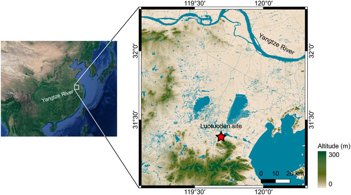
FIGURE 1. Map showing the location of the Luotuodun site (red star).
Meteorological data collected from 1981 to 2010 at the nearby Yixing station show the mean annual temperature and precipitation are 16.2°C and 1294.3 mm, respectively (China Meteorological Data Service Center, http://data.cma.cn). Approximately 40% of the precipitation occurs in summer, which means a strong effect of the East Asian Summer Monsoon on local precipitation. The natural vegetation types include subtropical broadleaf evergreen forest and mixed broadleaf evergreen and deciduous forest, but nowadays they are almost replaced by cultural vegetation such as Oryza sativa and Triticum aestivum (Su et al., 2020).
3 Materials and methods
3.1 Sample collection
We obtained a 386-cm sediment core (core LTD-12) in May 2013 from a rice field located outside the Luotuodun site (119°42′9.96″E, 31°21′44.82″N, 6 m a.s.l.). Core LTD-12 was sampled from a location 650 m away from the archaeological excavation area of the Luotuodun site. This location is close enough to record the environmental effects of human activity clearly, but far enough away from the main occupation area to avoid disturbance of the deposits’ stratigraphy. Core LTD-12 has yellowish-grey silt deposits that gradually darken upwards (386–251 cm), followed by a black peat layer (251–200 cm), dense blackish-grey silt deposits (200–128 cm), finer brownish-grey clayey silt deposits (128–47 cm), and taupe paddy soil with plant roots (47–0 cm). Core LTD-5 has similar lithology, with a black peat layer in the 240–210 cm interval. Upon returning to the laboratory, we sampled the cores at a resolution of 1 cm and stored them in a refrigerator at 4°C before analysis.
3.2 Radiocarbon dating
Five accelerator mass spectrometry (AMS) radiocarbon (14C) dates were obtained via organic sediments collected from core LTD-12, four of which have been published by Lu et al. (2019). For this study, we provide two new AMS 14C dates from the upper and lower bounds of the peat layer in core LTD-5 and convert them to the corresponding depths of core LTD-12. All samples were processed by the laboratory of Guangzhou Institute of Geochemistry, Chinese Academy of Sciences and measured by the State Key Laboratory of Nuclear Physics and Technology, Peking University, using standard procedures (acid–alkali–acid treatment).
3.3 Organic analysis
The TOC and TN (total nitrogen) contents were conducted on 126 samples from core LTD-12 and performed with a Vario EL cube elemental analyzer (Elementar, Germany). All the samples were dried at 25°C. We then tested the samples with 10% HCl, processed them with distilled water, and dried them at 50°C for 24 h to attain a pH of 7. The sample was ground in an agate mortar and passed through a 200-mesh sieve. The C/N ratio was calculated using the ratio of TOC to TN.
3.4 Grain-size analysis
Grain-size analysis was conducted on 126 samples from core LTD-12 and performed with a Malvern Mastersizer 2000 laser analyzer (Malvern, UK). We removed organic matter and carbonates before the examination by adding 10% H2O2 and 10% HCl, and then performed ultrasonic pre-treatment in a 0.05 mol/L (NaPO3)6 solution to disperse the samples for grain size determination.
3.5 Elemental analysis
The Rb and Sr contents were conducted on 126 samples from core LTD-12 and determined using an ARL 9800 XP+ (Thermo ARL, Switzerland). All samples were dried at 25°C. Each sample (no less than 5 g) was grounded with a <200 mesh in an agate mortar and then compacted the sample into a disc.
3.6 Palynological analysis
127 samples were extracted from core LTD-12 and processed following standard palynological techniques (Faegri et al., 1989), including treatment with HCl, KOH, HF and acetolysis treatment. One tablet of Lycopodium spores (27,637 ± 563 grains) was added to each sample for calculation of pollen concentrations. Identification followed pollen morphological atlases (Wang et al., 1995) aided by modern reference slides. Terrestrial pollen and fern spore data were previously presented (Lu et al., 2019). Terrestrial pollen percentages are calculated based on the pollen sum of trees, shrubs and upland herbs, while fern spores are calculated based on all the pollen. Here we present new wetland herb pollen data, expressed in terms of concentration (grains/g). Limited pollen remains were found in the lower part of core LTD-12, so this study focuses on the upper part (1–300 cm) and removes samples with less than 50 grains of terrestrial pollen. The pollen diagrams were plotted using Tilia software (Grimm, 1993) based on the remaining 91 data, and pollen assemblage zones were defined using CONISS (Grimm, 1987) based on all terrestrial pollen.
4 Results
4.1 Chronology
All 7 AMS 14C determinations are shown in Table 1. We rejected one 14C date from the 300 cm depth of core LTD-12 (sample GZ6730), as it is too young based on the dates from the bottom of the peat layer of core LTD-5 and profile T5033. Both suggest a likely age of 9,000 cal yr BP for the beginning of peat formation. Based on 6 14C dates, we generated an age-depth model for core LTD-12 using rbacon package 2.5.8 (Blaauw and Christen, 2011). The 14C dates were calibrated with reference to the IntCal20 (Reimer et al., 2020). Ages are expressed as calendar years before the present (cal yr BP, defined the present as 1950 CE). The age-depth model (Figure 2) shows the age coverage ranges from 12,800 to 2,100 cal yr BP for the 386–51 cm layer.
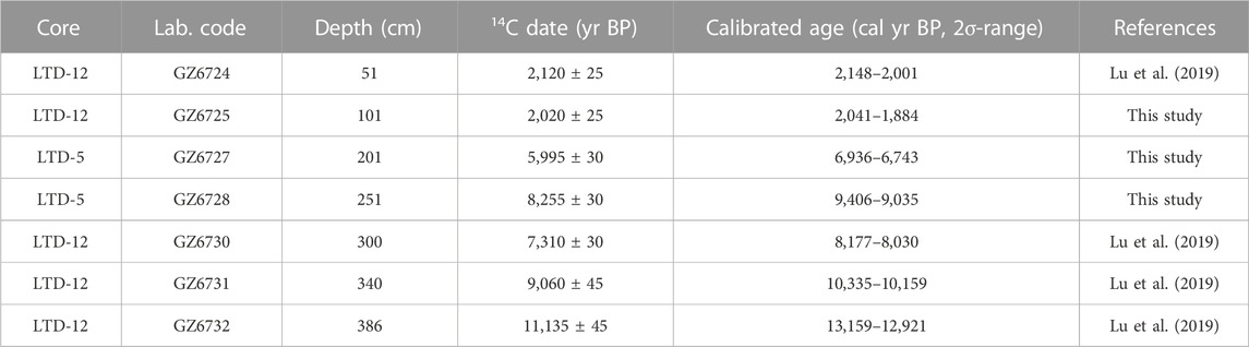
TABLE 1. AMS14C dates for core LTD-12 and LTD-5.
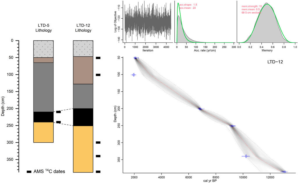
FIGURE 2. Lithology of cores LTD-5 and LTD-12, and age-depth model of core LTD-12. Locations of the dating samples are shown on the right side of the lithology pictures by black rectangles. The colours represent different lithologies: From top to bottom are yellowish-grey silt deposits, black peat, dense blackish-grey silt deposits, finer brownish-grey clayey silt deposits and taupe paddy soil.
4.2 Palaeoenvironmental proxies
We present the mean grain size (Mz), Rb and Sr contents, Rb/Sr ratio, TOC, and C/N ratio in Figure 3. According to the lithology and multi-proxy records, we divided core LTD-12 into four environmental units.
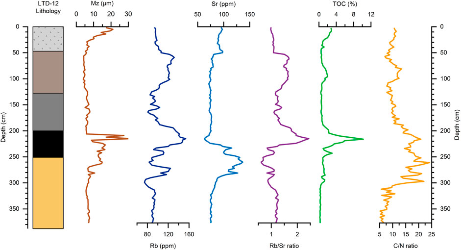
FIGURE 3. Multi-proxy record of core LTD-12. From left to right: lithology, mean grain size (Mz), Rb and Sr contents, Rb/Sr ratio, total organic carbon (TOC), C/N ratio.
Mz in Units 1 and 3 from depths of 377–301 and 206–47 cm, respectively, were fine and remained constant, ranging between 4.01 and 7.85 μm. The middle section (Unit 2, 300–207 cm) was characterized by coarser Mz and considerably fluctuated, ranging between 6.63 and 31.35 μm. The upper section (Unit 4, 46–1 cm) was a cultivated layer disturbed by humans, and its Mz increased from 5.25 to 21.22 μm.
The Rb and Sr contents variations exhibited roughly opposite trends, except for some rapid fluctuations. The Rb contents fluctuate widely, averaging 103.6 ppm. Comparatively, the Sr contents exhibited relatively high values in 287–227 cm averaging 114.5 ppm, whereas relatively lower values in 377–288 and 226–1 cm averaging 78.5 ppm. The Rb/Sr ratio averages 1.27, with a distinct peak between 224 and 206 cm.
In Unit 1, the TOC content and C/N ratio remained stable, ranging from 0.21% to 0.50% and 5.10 to 11.45, respectively. In Unit 2, the TOC content increased and reached a maximum value of 10.22% at a depth of 215 cm. We observed distinct changes in the C/N ratio in this unit, ranging from 13.19 to 24.18, with an average of 18.07. In Unit 3, the TOC content and C/N ratio showed the same changes: TOC content decreased to a low and stable state ranging from 0.43% to 3.31%; the C/N ratio gradually decreased and ranged from 7.03 to 16.98 with an average value of 10.66. In Unit 4, the TOC content and C/N ratio gradually increased, ranging from 0.49% to 2.88% and 8.41 to 11.40, respectively.
4.3 Palaeovegetation proxies
Forty-two terrestrial pollen taxa were identified from core LTD-12 (Lu et al., 2019). The main tree pollen taxa are Pinus, Quercus evergreen, Quercus deciduous, and Liquidambar; and the main herb pollen taxa are Artemisia, Cruciferae, and Poaceae. Four palaeovegetation zones (1–4) were recognized according to CONISS analysis (Figure 4).
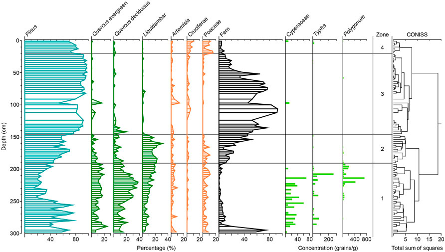
FIGURE 4. Pollen diagram for core LTD-12. The results of CONISS are shown on the right.
Zone 1 (298–191 cm, 10,100–6,500 cal yr BP), pollen data show a high percentage of broadleaved content, with a decrease in Pinus. Additionally, fern content remains low except at the bottom.
Zone 2 (190–146 cm, 6,500–4,800 cal yr BP), the pollen percentages of both Quercus evergreen and Quercus deciduous decline in abundance (with fluctuations) throughout this zone, but Liquidambar remains at the highest level (18.8% on average). Pinus expansion is observed, accompanied by the rising proportions of ferns.
Zone 3 (145–20 cm, 4,800–2,100 cal yr BP), this zone was characterized by the absolute dominance in the pollen percentage of Pinus (88.8% on average) and the almost disappearance of Quercus and Liquidambar at the start of this period, coincident with an abundance of fern content.
Zone 4 (19–1 cm, after 2,100 cal yr BP), this zone is characterized by increases in the pollen percentages of Cruciferae (5.9% on average) and Poaceae (9.6% on average), which are the two most abundant agricultural-associated taxa. On the contrary, the pollen percentages of Pinus decrease slightly.
Wetland herb pollen taxa include Cyperaceae, Typha, and Polygonum. Pollen data show that wetland herbs occur mainly in Zone 1 with an average concentration of 92.4 grains/g, while almost no wetland herb pollen exists in Zone 2–4.
5 Discussion
5.1 Marsh dynamic
The C/N ratio and wetland herb pollen record are reliable indicators of marshland existence. In the Lower Yangtze region, the dominant pollen taxa in freshwater wetland habitats are Cyperaceae and Typha, which are often used to indicate marsh/wetland environments (Zong et al., 2007; Tang et al., 2019). Polygonum is also an important taxon in marshland environments (Ge et al., 2019). Li et al. (2009) identified a total of 413 plant fossils in the peat layer at the Luotuodun site, which contains a large number of Polygonum seeds. Additionally, the high C/N ratios of peat sediments, which have a fibric or hemic appearance and substantial plant-derived contributions, are significantly higher than those of mineral soils (Leifeld et al., 2020). Therefore, the high concentration of wetland herb pollen combined with the high level of C/N ratios between 10000 and 6500 cal yr BP indicates the persistence of the marshland landscape.
In this paper, we pay more attention to the process of the disappearance of marshland. Before the end of the marsh layer, Mz suddenly increased between 7500 and 7000 cal yr BP, with Rb/Sr ratio synchronously reaching a maximum (Figure 5). Although there are controversial explanations regarding grain-size indexes (Chen et al., 2021), the significant fluctuations in Mz indicate changes in the sedimentary environment. The Rb/Sr ratio has been widely used as a proxy for chemical weathering intensity (Yang et al., 2020), where a high Rb/Sr ratio indicates an enhancement of chemical weathering (Liu et al., 2014). This is because Sr typically substitutes for Ca in carbonate minerals and is more geochemically reactive than Rb (Liu et al., 2021). Complementary evidence from profile T5033 within the Luotuodun site corroborates the human–marsh interaction: The peat layer beneath the cultural layer (9th layers) is interspersed with pottery pieces, which began at 7212 ± 55 cal yr BP (2σ) (Supplementary Figure S1) (Nanjing Museum Archaeological Research Institute, 2003; Li et al., 2009; Li, 2011). Therefore, we attribute the changes in Mz and Rb/Sr ratio to anthropogenic disturbance in the marshland, which led to the degradation of marshlands and the intensification of soil erosion. By the time 6500 cal yr BP, the low-lying marsh was completely transformed, and the Neolithic community had built a massive settlement on the remains of the marshland.
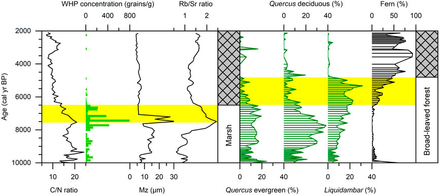
FIGURE 5. Comparison of palaeoenvironmental and palaeovegetation proxies in core LTD-12. The shaded yellow bars indicate the intervals that the marsh and forest are subjected to human disturbance.
5.2 Vegetation succession
Palynological evidence reveals that high forest cover was maintained in southern China during the mid-Holocene (Yi et al., 2003; Zhu et al., 2010; Yue et al., 2012; Li et al., 2013; Ma et al., 2016; Zhao et al., 2021); that was, sustained recovery since the Lateglacial, consistent with intensifying East Asian Summer Monsoon and warm climate. Although some recent studies based on non-pollen proxies indicate a drier mid-Holocene (e.g., Xie et al., 2013; Liu et al., 2019; Liu et al., 2021), these studies require complementary explanations for the possible decoupling of vegetation and precipitation changes.
In the Luotuodun area, the mixed broadleaf evergreen and deciduous forest, composed mainly of Quercus and Liquidambar, continued to exist between 10100 and 6500 cal yr BP (Zone 1 in the pollen assemblages, Figure 4). The decrease in Pinus and increase in Quercus mostly occurred between 9000–6500 cal yr BP, which is likely due to climatic factors as there is no evidence of Neolithic remains in the western Taihu Lake area during the early Holocene (Li, 2011). After 6500 cal yr BP, the pollen assemblages changed dramatically, reflecting an obvious shift in the regional vegetation landscape (Zone 2 in the pollen assemblages, Figure 4). This zone is characterized by declines in both Quercus evergreen and Quercus deciduous. However, this decline of the broad-leaved forest is not consistent with the relatively stable climate background by this time (Zhang et al., 2021). We conclude that changes in precipitation cannot explain the near-total disappearance of Quercus. Meanwhile, the fern that thrives in areas disturbed by forest clearance expanded sharply. We therefore contend such a big change in vegetation composition is caused by human deforestation, and further, date the onset of human deforestation to 6500 cal yr BP (Figure 5).
At 4800 cal yr BP, the broadleaf forest collapsed ecologically with the disappearance of Liquidambar. Pinus (especially Pinus massoniana) is a kind of secondary conifer species (Ma et al., 2020). For the period after 4800 cal yr BP, the long-term absolute dominance of Pinus indicates that a resemble modern landscape has formed.
5.3 Asynchronous destruction of marsh and forest
The inherent error and “old wood” problem of AMS 14C dating would interfere with our determination of the absolute age at which events occurred and thus hinder us from understanding the sequencing of the anthropogenic transformation of marsh and forest based on different studies. However, multi-proxy analysis of a single core can subtly avoid this uncertainty. Our study provides evidence of a pre-existing anthropogenic transformation of the marsh dating back to 7500 cal yr BP, which occurred 1000 years prior to the man-made destruction of the broadleaf forest (Figure 5).
There are simple explanations for the Neolithic ancients’ preference for transforming marshlands. The importance of marshes on low-lying plains to Neolithic communities has been studied, as they provided valuable sources of food (Ma et al., 2020; Shao et al., 2021); the findings emphasize that marshlands, including lakeside and coastal swamps, would have been the ecological zone most suitable for the earliest rice cultivation (Zong et al., 2007). More importantly, the lush subtropical evergreen forests in the Lower Yangtze hindered settlement and movement in the Neolithic period (Zhao, 2016), because deforestation without iron tools was laborious.
In addition, we highlight some possible flaws in previous studies of past land use. As the marsh landscape is difficult to be reflected in the regional pollen signal, the footprint of marshland dynamics has been ignored. Therefore, the first beginning and intensity of the anthropogenic transformation of the terrestrial landscape may be greatly underestimated.
6 Conclusion
This study presents a detailed multi-proxy analysis of cores from the Luotuodun area, providing evidence for past land use. Our results show that the marsh was first disturbed by the Neolithic community at 7500 cal yr BP and subsequently destroyed at 6500 cal yr BP. Deforestation began at 6500 cal yr BP, resulting in the complete clearance of the original mixed evergreen and deciduous broadleaf forest by 4800 cal yr BP. Interestingly, prior to the confirmed deforestation, there was a priority for the transformation of marshes in low-lying areas. Our findings highlight a potential flaw in previous studies of past human land use, as the emergence and evolution of anthropogenic landscapes may have been greatly underestimated due to the lack of direct evidence of marshland changes.
Data availability statement
The raw data supporting the conclusion of this article will be made available by the authors, without undue reservation.
Author contributions
ZD: Conceptualization, formal analysis, writing, visualization. CM: Funding acquisition, methodology, project administration, supervision. LW: Investigation. YT: Investigation. KW: Investigation. LL: Supervision. DZ: Supervision. TS: Funding acquisition, supervision. CZ: Resources. All authors contributed to manuscript revision, read, and approved the submitted version.
Funding
This study was supported by Major project of National Social Science Fund of China (No. 20&ZD247), the National Natural Science Foundation of China (Nos. 41977389 and 42271173), the Frontiers Science Center for Critical Earth Material Cycling Fund (No. JBGS2102), and the Fundamental Research Funds for the Central Universities (No. 0209-14380097).
Conflict of interest
The authors declare that the research was conducted in the absence of any commercial or financial relationships that could be construed as a potential conflict of interest.
Publisher’s note
All claims expressed in this article are solely those of the authors and do not necessarily represent those of their affiliated organizations, or those of the publisher, the editors and the reviewers. Any product that may be evaluated in this article, or claim that may be made by its manufacturer, is not guaranteed or endorsed by the publisher.
Supplementary material
The Supplementary Material for this article can be found online at: https://www.frontiersin.org/articles/10.3389/feart.2023.1143231/full#supplementary-material
References
Atahan, P., Itzstein-Davey, F., Taylor, D., Dodson, J., Qin, J., Zheng, H., et al. (2008). Holocene-aged sedimentary records of environmental changes and early agriculture in the lower Yangtze, China. Quat. Sci. Rev. 27, 556–570. doi:10.1016/j.quascirev.2007.11.003
Blaauw, M., and Christen, J. A. (2011). Flexible paleoclimate age-depth models using an autoregressive gamma process. Bayesian Anal. 6. doi:10.1214/11-ba618
Chen, H., Zhu, L., Wang, J., Ju, J., Ma, Q., and Xu, T. (2021). Paleoclimate changes over the past 13,000 years recorded by Chibuzhang Co sediments in the source region of the Yangtze River, China. Palaeogeogr. Palaeoclimatol. Palaeoecol. 573, 110433. doi:10.1016/j.palaeo.2021.110433
Ellis, E. C., Kaplan, J. O., Fuller, D. Q., Vavrus, S., Klein Goldewijk, K., and Verburg, P. H. (2013). Used planet: A global history. Proc. Natl. Acad. Sci. U. S. A. 110, 7978–7985. doi:10.1073/pnas.1217241110
Ellis, E. C., Gauthier, N., Klein Goldewijk, K., Bliege Bird, R., Boivin, N., Diaz, S., et al. (2021). People have shaped most of terrestrial nature for at least 12,000 years. Proc. Natl. Acad. Sci. U. S. A. 118, e2023483118. doi:10.1073/pnas.2023483118
Faegri, K., Kaland, P. E., and Krzywinski, K. (1989). Textbook of pollen analysis. John Wiley & Sons Ltd.
Foley, J. A., Defries, R., Asner, G. P., Barford, C., Bonan, G., Carpenter, S. R., et al. (2005). Global consequences of land use. Science 309, 570–574. doi:10.1126/science.1111772
Fuller, D. Q., and Stevens, C. J. (2019). Between domestication and civilization: The role of agriculture and arboriculture in the emergence of the first urban societies. Veg. Hist. Archaeobot 28, 263–282. doi:10.1007/s00334-019-00727-4
Fuller, D. Q., Qin, L., Zheng, Y., Zhao, Z., Chen, X., Hosoya, L. A., et al. (2009). The domestication process and domestication rate in rice: Spikelet bases from the lower Yangtze. Science 323, 1607–1610. doi:10.1126/science.1166605
Ge, Y., Zhang, K., and Yang, X. (2019). A 110-year pollen record of land use and land cover changes in an anthropogenic watershed landscape, eastern China: Understanding past human-environment interactions. Sci. Total Environ. 650, 2906–2918. doi:10.1016/j.scitotenv.2018.10.058
Grimm, E. C. (1987). CONISS - a FORTRAN-77 program for stratigraphically constrained cluster-analysis by the method of incremental sum of squares. Comput. Geosciences 13, 13–35. doi:10.1016/0098-3004(87)90022-7
Grimm, E. (1993). TILIA v2. 0 (computer software). Springfield, II: Illinois State Museum, Research and Collections Center.
He, K., Lu, H., Sun, G., Wang, Y., Zheng, Y., Zheng, H., et al. (2022). Dynamic interaction between deforestation and rice cultivation during the holocene in the lower Yangtze river, China. Front. Earth Sc-Switz 10. doi:10.3389/feart.2022.849501
Leifeld, J., Klein, K., and Wust-Galley, C. (2020). Soil organic matter stoichiometry as indicator for peatland degradation. Sci. Rep. 10, 7634. doi:10.1038/s41598-020-64275-y
Li, L., Zhu, C., Lin, L., Zhao, Q., Shi, G., Zheng, C., et al. (2009). Evidence for marine transgression between 7500–5400BC at the Luotuodun site in yixing, jiangsu province. J. Geogr. Sci. 19, 671–680. doi:10.1007/s11442-009-0671-2
Li, J., Zheng, Z., Huang, K., Yang, S., Chase, B., Valsecchi, V., et al. (2013). Vegetation changes during the past 40,000 years in Central China from a long fossil record. Quat. Int. 310, 221–226. doi:10.1016/j.quaint.2012.01.009
Li, L. (2011). Research on the environmental evolution and the missing reasons of the archeaological sites in Early Holocene in Taihu Lake area. Doctor. Nanjing: Nanjing University.
Liu, J., Chen, J., Selvaraj, K., Xu, Q., Wang, Z., and Chen, F. (2014). Chemical weathering over the last 1200 years recorded in the sediments of gonghai lake, lvliang mountains, north China: A high-resolution proxy of past climate. Boreas 43, 914–923. doi:10.1111/bor.12072
Liu, B., Wang, N., Chen, M., Wu, X., Mo, D., Liu, J., et al. (2017). Earliest hydraulic enterprise in China, 5,100 years ago. Proc. Natl. Acad. Sci. U. S. A. 114, 13637–13642. doi:10.1073/pnas.1710516114
Liu, H., Gu, Y., Huang, X., Yu, Z., Xie, S., and Cheng, S. (2019). A 13,000-year peatland palaeohydrological response to the ENSO-related Asian monsoon precipitation changes in the middle Yangtze Valley. Quat. Sci. Rev. 212, 80–91. doi:10.1016/j.quascirev.2019.03.034
Liu, J. B., Shen, Z. W., Chen, W., Chen, J., Zhang, X., Chen, J. H., et al. (2021). Dipolar mode of precipitation changes between north China and the Yangtze River Valley existed over the entire Holocene: Evidence from the sediment record of Nanyi Lake. Int. J. Climatol. 41, 1667–1681. doi:10.1002/joc.6906
Liu, Y., Xiao, L., Cheng, Z., Liu, X., Dai, J., Zhao, X., et al. (2023). Anthropogenic impacts on vegetation and biodiversity of the lower Yangtze region during the mid-Holocene. Quaternary Sci. Rev. 299.
Lu, F. Z., Ma, C. M., Zhu, C., Lu, H. Y., Zhang, X. J., Huang, K. Y., et al. (2019). Variability of East Asian summer monsoon precipitation during the Holocene and possible forcing mechanisms. Clim. Dynam 52, 969–989. doi:10.1007/s00382-018-4175-6
Ma, T., Tarasov, P. E., Zheng, Z., Han, A., and Huang, K. (2016). Pollen- and charcoal-based evidence for climatic and human impact on vegetation in the northern edge of Wuyi Mountains, China, during the last 8200 years. Holocene 26, 1616–1626. doi:10.1177/0959683616641744
Ma, T., Rolett, B. V., Zheng, Z., and Zong, Y. (2020). Holocene coastal evolution preceded the expansion of paddy field rice farming. Proc. Natl. Acad. Sci. U. S. A. 117, 24138–24143. doi:10.1073/pnas.1919217117
Nanjing Museum Archaeological Research Institute (2003). Excavation on the neolithic Luotuodun site in yixing city, jiangsu. Archaelogy 7, 579–585. (In Chinese).
Nanjing Museum, Yixing Cultural Heritage Administration Committee (2009). An excavation report of Luotuodun site in Yixing. Jiangsu. Southeast Cult. 211, 26–44. (In Chinese).
Reimer, P. J., Austin, W. E. N., Bard, E., Bayliss, A., Blackwell, P. G., Bronk Ramsey, C., et al. (2020). The IntCal20 northern hemisphere radiocarbon age calibration curve (0–55 cal kBP). Radiocarbon 62, 725–757. doi:10.1017/rdc.2020.41
Shao, K., Zhang, J., He, K., Wang, C., and Lu, H. (2021). Impacts of the wetland environment on demographic development during the neolithic in the lower Yangtze region—based on peat and archaeological dates. Front. Earth Sc-Switz 9. doi:10.3389/feart.2021.635640
Su, Y., Guo, Q., Hu, T., Guan, H., Jin, S., An, S., et al. (2020). An updated vegetation map of China (1:1000000). Sci. Bull. 65, 1125–1136. doi:10.1016/j.scib.2020.04.004
Tang, L., Shu, J., Chen, J., and Wang, Z. (2019). Mid-to late Holocene vegetation change recorded at a Neolithic site in the Yangtze coastal plain, East China. Quat. Int. 519, 122–130. doi:10.1016/j.quaint.2018.12.031
Xie, S., Evershed, R. P., Huang, X., Zhu, Z., Pancost, R. D., Meyers, P. A., et al. (2013). Concordant monsoon-driven postglacial hydrological changes in peat and stalagmite records and their impacts on prehistoric cultures in central China. Geology 41, 827–830. doi:10.1130/g34318.1
Yang, H., Zhao, Y., Cui, Q., Ren, W., and Li, Q. (2020). Paleoclimatic indication of X-ray fluorescence core-scanned Rb/Sr ratios: A case study in the zoige basin in the eastern Tibetan plateau. Sci. China Earth Sci. 64, 80–95. doi:10.1007/s11430-020-9667-7
Yi, S., Saito, Y., Zhao, Q., and Wang, P. (2003). Vegetation and climate changes in the Changjiang (Yangtze River) Delta, China, during the past 13,000 years inferred from pollen records. Quat. Sci. Rev. 22, 1501–1519. doi:10.1016/s0277-3791(03)00080-5
Yue, Y., Zheng, Z., Huang, K., Chevalier, M., Chase, B. M., Carré, M., et al. (2012). A continuous record of vegetation and climate change over the past 50,000years in the Fujian Province of eastern subtropical China. Palaeogeogr. Palaeoclimatol. Palaeoecol. 365-366, 115–123. doi:10.1016/j.palaeo.2012.09.018
Zhang, Z., Liu, J., Chen, J., Chen, S., Shen, Z., Chen, J., et al. (2021). Holocene climatic optimum in the East Asian monsoon region of China defined by climatic stability. Earth-Science Rev. 212, 103450. doi:10.1016/j.earscirev.2020.103450
Zhao, L., Ma, C., Wen, Z., Ye, W., Shang, G., and Tang, L. (2021). Vegetation dynamics and their response to Holocene climate change derived from multi-proxy records from Wangdongyang peat bog in southeast China. Veg. Hist. Archaeobotany 31, 247–260. doi:10.1007/s00334-021-00852-z
Zhao, D. (2016). Discussion on the relationship between the water change and cultural evolution around the Taihu Lake. Cult. Relics South. China 3, 201–207. (In Chinese).
Zhu, C., Ma, C. M., Yu, S. Y., Tang, L. Y., Zhang, W. Q., and Lu, X. F. (2010). A detailed pollen record of vegetation and climate changes in Central China during the past 16 000 years. Boreas 39, 69–76. doi:10.1111/j.1502-3885.2009.00098.x
Keywords: land use, anthropogenic landscape, marsh degradation, deforestation, Neolithic
Citation: Deng Z, Ma C, Wu L, Tan Y, Wang K, Lin L, Zhao D, Shui T and Zhu C (2023) Asynchronous destruction of marsh and forest in Neolithic age: An example from Luotuodun site, Lower Yangtze. Front. Earth Sci. 11:1143231. doi: 10.3389/feart.2023.1143231
Received: 12 January 2023; Accepted: 29 March 2023;
Published: 09 May 2023.
Edited by:
Ren Lele, Lanzhou University, ChinaReviewed by:
Yan Liu, East China Normal University, ChinaKai Li, Zhejiang Normal University, China
Yongbo Wang, Capital Normal University, China
Copyright © 2023 Deng, Ma, Wu, Tan, Wang, Lin, Zhao, Shui and Zhu. This is an open-access article distributed under the terms of the Creative Commons Attribution License (CC BY). The use, distribution or reproduction in other forums is permitted, provided the original author(s) and the copyright owner(s) are credited and that the original publication in this journal is cited, in accordance with accepted academic practice. No use, distribution or reproduction is permitted which does not comply with these terms.
*Correspondence: Chunmei Ma, Y2h1bm1laW1hQG5qdS5lZHUuY24=