- 1College of Geography and Ocean Sciences, Yanbian University, Hunchun, China
- 2Jilin Provincial Joint Key Laboratory of Changbai Mountain Wetland and Ecology, Changchun, China
- 3Wangqing County No. 1 Secondary School, Wangqing, China
- 4Jilin Province Key Laboratory of Changbai Mountain Wetland Ecosystem Function and Ecological Security, Hunchun, China
- 5Tumen River Basin Wetland and Ecology International Joint Research Center of Jilin Province, Hunchun, China
- 6Wetland Research Center of Yanbian University, Yanbian University, Hunchun, China
Deyeuxia angustifolia acts as an indicator of the changes in wetland ecosystems and plays an important ecological role in their functions. Previous studies have shown that the Tumen River Basin is of wide global interest as a transboundary basin area with abundant wetland ecological resources. Despite the implementation of wetland conservation measures in recent years, the distribution area of D. angustifolia in this basin has been reduced due to climate change and anthropogenic activities. Therefore, we used MaxEnt and geographic information system to model a suitable habitat for this species, simulated changes in the habitat, and applied Jackknife to assess the influencing environmental variables. The Jackknife tests showed that slope orientation, solar radiation in September, and total nitrogen were the dominant environmental factors affecting the potential distribution of D. angustifolia. Compared to the current distribution, the total area of land highly and moderately suitable for this species will decrease in the 2050’s and 2070’s, respectively, under two representative concentration paths (RCPs), shifting the centroid of its suitable area and direction of wetland degradation to the northeast. Our study of the projected potential distribution of D. angustifolia in the basin under future climate change could provide important information for its conservation, management, sustainable use, and early warning to prevent its extinction.
Introduction
D. angustifolia is a perennial saprophytic herb of the grass family Wild Cycads, with a cold-temperate habitat (Mark et al., 1993), growing mainly in mountain hinterland grasslands, forest grasslands, and roadside and ditch-side wetlands at elevations of 680–2,300 m. It easily forms pure stands in seasonally flooded swamps and wet grasslands (Zhang et al., 2014), and is a wet mesophytic, clump-forming plant typical of meadows, and a dominant species in wet meadow and swamp communities (Hongwei et al., 1998). As D. angustifolia likes moist environments, it grows well in wetland protruding towers and highly humid locations, and has a wide range of moisture adaptation, high drought tolerance, and a well-developed root system, and can grow well in dry environments. It is mainly distributed in the northeast of China, with the highest concentration in the Sanjiang Plain (Zhou et al., 1992). D. angustifolia is rich in nutrition, has high edible value, and can provide high-quality forage for livestock (Lupo et al., 1991).
D. angustifolia grows easily in wet environments, which gradually reduces the moisture of the wetland, further enhancing the suitability of the environment for its growth. The reduction of wetland moisture has been found to lead to wetland degradation (Zhao et al., 2021), and previous studies have suggested that IndVal values ≥0.5 indicate a degraded wetland and that D. angustifolia can be an indicator of such conditions (Xuemei 2019). The IndVal value of wetland vegetation in the Tumen River Basin (TRB) is 0.628, indicating that wetlands with high growth of D. angustifolia may have a degradation risk. The degradation rate of wetlands is mainly manifested in the change of the fitness zone of D. angustifolia and also reflects the change in wetland health, which plays an important role in wetland ecology. Therefore, the changes in the growth status and fitness zone of D. angustifolia are of great significance in predicting wetland degradation.
The TRB is an important support area for the national implementation of the “The Belt and Road1” strategy, with diverse wetland types and rich species in the region (Jin 2019). In recent years, the TRB has been subject to climate change and human interference, resulting in the gradual degradation of wetlands in the basin and a significant decrease (22.39%) in wetland area from 1,161.80 km2 in 1976 to 901.62 km2 in 2016, exhibiting an average annual decrease of 6.50 km2 (Zhang H. et al., 2020). These changes primarily occurred due to the rapid conversion of wetlands to drylands and construction land, which poses a serious threat to the ecological security of wetlands (Liu et al., 2021). This has led to major issues, such as the decline in functional services of wetland ecosystems and the loss of water-holding capacity. Therefore, this study examines the changes in the habitat area of D. angustifolia, which are useful for monitoring the status and rate of wetland degradation in the region (Yang et al., 2020). In addition, it provides a scientific and theoretical basis for the future conservation of wetland species and the stable development of wetland ecosystems in the TRB.
In this study, data from 42 sampling sites, soil data from the same sites, and environmental data under the current and future BCC-CSM1-1 models (Simulation of RCP2.6, 8.5 scenarios) combined with the MaxEnt model were used to investigate and predict the distribution of suitable areas for D. angustifolia. The specific objectives of this study are to 1) observe the current distribution of D. angustifolia habitats in the TRB and predict the future distribution of their habitats in the basin in the 2050’s and 2070’s using the RCP2.6 and RCP8.5 models; 2) determine the overall changes in their habitat area in the TRB by predicting these changes from the present to 2050–2070; 3) determine the direction and distance of D. angustifolia habitat development by shifting the center of mass of their habitat; and 4) determine the main environmental factors affecting the distribution of D. angustifolia habitat, and provide a reasonable basis for predicting the degradation of wetlands in the TRB to achieve healthy and sustainable development of these wetland ecosystems.
Materials and methods
Study area
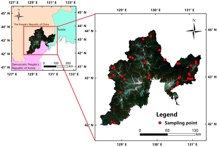
The TRB is located in the cross-border area of China, North Korea, and Russia, bordering Russia to the east and North Korea to the south, with geographic coordinates of 41°59′N–44°30′N, 127°27′E–131°18′ E. The basin and wetland areas are 22616.14 and 191.20 km2, respectively (Zhang Y. et al., 2020). This area is in the middle temperate humid monsoon climate, with an average annual temperature of 5.9°C, maximum and minimum average temperatures of 36°C and −32°C, respectively, and average precipitation of 551.7 mm (Zhu et al., 2014). The TRB has various types of wetland ecosystems with rich wetland resources and high biodiversity, as well as a transient habitat for endangered migratory birds and various rare plants and animals, making it one of the most important territories for maintaining biodiversity in Northeast Asia (Zheng et al., 2017).
Data source
Distribution data for July–September 2017 were obtained from 42 D. angustifolia sample sites within the TRB wetland patches (Figure 1), including 14 forested swamp, 13 herbaceous swamp, 7 riverine, 6 scrub swamp, and 2 artificial wetlands. Soil factor data were obtained from wetland soil samples collected in the field during the same period at a depth of 0–20 cm. The samples were placed in vinyl self-sealing bags and recorded with numbers (numbers were consistent with the vegetation collection numbers). The water content was measured through the drying method, the pH was measured using an acidity meter, the soil total nitrogen was determined through the sulfuric acid-perchloric acid digestion-semi-micro Kjeldahl method, the soil total phosphorus was determined through the sodium hydroxide fusion-molybdenum antimony anti-colorimetric method, and the soil total potassium was determined through sodium hydroxide fusion. The measured surface soil data were screened and the abnormal values were rejected in SPSS.
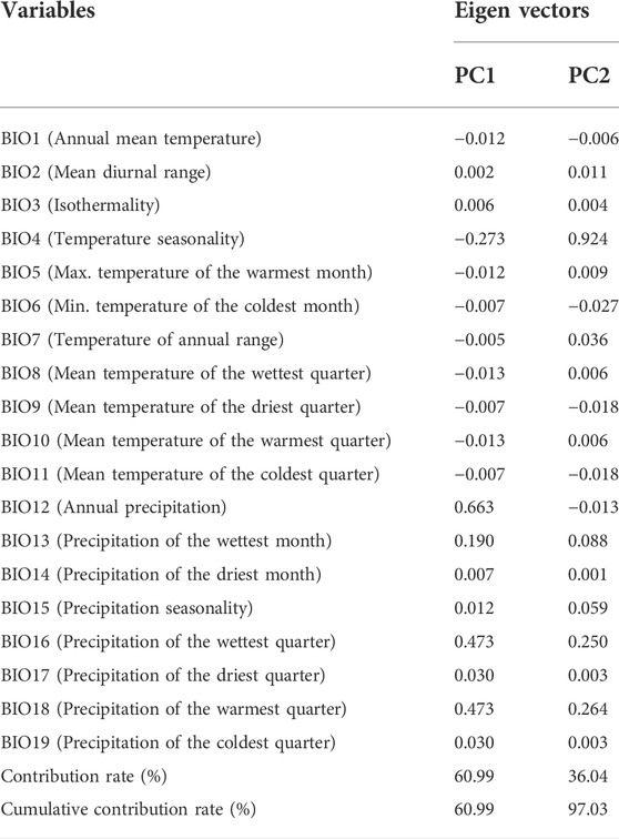
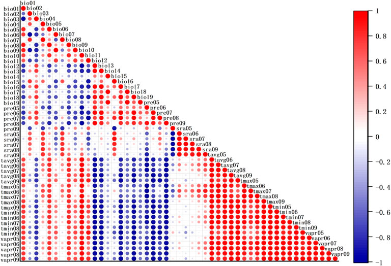
The topographic factors studied included the elevation, slope, and slope direction, and the elevation data were the actual measured (GPS) data of the sample site at that time. Both the slope and slope orientation were obtained from Digital Elevation Model (DEM) data by spatial extraction and analysis (http://www.gscloud.cn/), and the resolution of the DEM data was 30 m × 30 m. The climate database for current and future scenarios was downloaded from the WorldClim database (http://world clim.org/) and included 19 bioclimatic variables (numbered in order bio1-bio19) and 30 monthly meteorological factors (Qingliang et al., 2017), with the downloaded climate data at a resolution of 30´ × 30´. To reduce covariance, principal component analysis (Table 1) was performed on the 19 biometeorological factors and a Pearson correlation test was performed with the 30 monthly meteorological factors (Xiao-Ge et al., 2013). According to the correlation results (Figure 2), environmental variables with correlation coefficients of >0.8 were excluded, and the final selection of 16 environmental variables, which were identified as the final modeling data, are listed in Supplementary Table S1.
MaxEnt model prediction and result evaluation methods
The distribution data of D. angustifolia in the TRB with topographic, climatic, and soil data were input into the MaxEnt model to predict the potential distribution areas of the leaflet chapter; 75% of the data were randomly selected as training data to train the model, and the remaining 25% of the data were used as the evaluation subset (testing data) to validate the model (Ye et al., 2019). The evaluation of the model-related performance was conducted using the area under the receiver operating characteristic curve (AUC), and the average training AUC value was automatically calculated when the MaxEnt model was repeatedly run 10 times. The AUC value of the training data was generally between 0 and 1, and the prediction results converged to 1 infinitely, indicating better prediction results (Luo-rong et al., 2007). The AUC evaluation criteria were: 0.5–0.7, low accuracy; 0.7–0.8, average accuracy; 0.8–0.9, good accuracy; and >0.9, very good accuracy (Jessica et al., 2014). Ten iterations were performed for the MaxEnt model and the logical output format.
Jackknife analyses to validate the influence of environmental variables
Jackknife validation built the model by sequentially using and excluding one environmental variable until all environmental variables were used. The importance of the environmental variables was expressed as the regularized training gain, test gain, and AUC value results. The Jackknife test used bioclimatic variables sequentially to exclude certain ones while building the model and provided three checks: regularized training gain, test gain, and AUC value (Wang et al., 2021). The results were used to measure the importance of the environmental variables (Zhang H. et al., 2020). The knife-cut method was chosen to assess the contribution of environmental variables and thresholds to the potentially suitable areas for D. angustifolia within the TRB.
Species suitability division
The suitability index of D. angustifolia was classified using the manual grading method in the reclassification tool in ArcGIS 10.8 software (Yixin 2021). In the statistical principle, when p < 0.05, the probability of D. angustifolia distribution is small and the occupied area is not suitable for its growth; the closer the value to 1, the greater the probability of D. angustifolia existence and the more suitable the occupied area is for its growth. The remaining possibilities were classified as: 0.05–0.1, low suitability; 0.1–0.5, medium suitability; and >0.5, high suitability (Guojun et al., 2012). Different suitability classes were calculated in the ArcGIS 10.8 spatial analysis module (SDM toolbox) (Brown 2014; Che et al., 2014). In addition, the changes in the area of D. angustifolia fitness zones between the present and 2050’s or 2070’s were compared in ArcGIS 10.8, as well as the changes in the area conversion of fitness zones under different climate change scenarios in the future.
Results
MaxEnt model prediction result accuracy evaluation
In this study, the accuracy of the results predicted by the MaxEnt model was tested using the receiver operating characteristic curves, and the working characteristic curves of the simulation results based on 10 iterations of objects are shown in Figure 3. The AUC value of the MaxEnt prediction results was 0.807, which was significantly larger than that of the random prediction distribution model. This indicates that the MaxEnt model prediction results were “very good” and reliable in simulating the D. angustifolia distribution area of TRB.
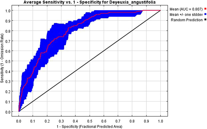
FIGURE 3. Receiver operating characteristic curve and area under the curve value of potential distribution prediction results of Deyeuxia angustifolia.
Present and future changes in the suitable area of Deyeuxia angustifolia in Tumen River Basin
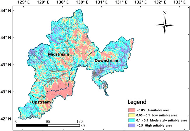
The predicted potential distribution of D. angustifolia is shown in Figure 4; the larger the value shown in the result, the more suitable the area is for the survival of D. angustifolia. In increasing order of suitability, the high-suitability areas of D. angustifolia are mainly located in the northwestern part of the upper Tumen River, the western part of the middle Tumen River, and the eastern part of the lower Tumen River. D. angustifolia serves as an indicator for degraded wetlands, so the degradation rate of wetlands in the lower reaches of the TRB is much greater than that in the upper and middle reaches of the Tumen River, and is mainly concentrated in the eastern and western parts of TRB. The high-fitness zone of D. angustifolia is mainly located at the intersection of rivers and forest swamps, and near paddy fields in the eastern and western areas of the TRB, where the rate of wetland degradation is faster. The area and proportion of suitable areas in the TRB are as follows: high suitability—2,268.40 km2 (10.03%); medium suitability—12,027.26 km2 (53.18%); low suitability—3,485.15 km2 (15.41%); non-suitable—4,835.33 km2 (21.38%).
Future suitable area of D. angustifolia
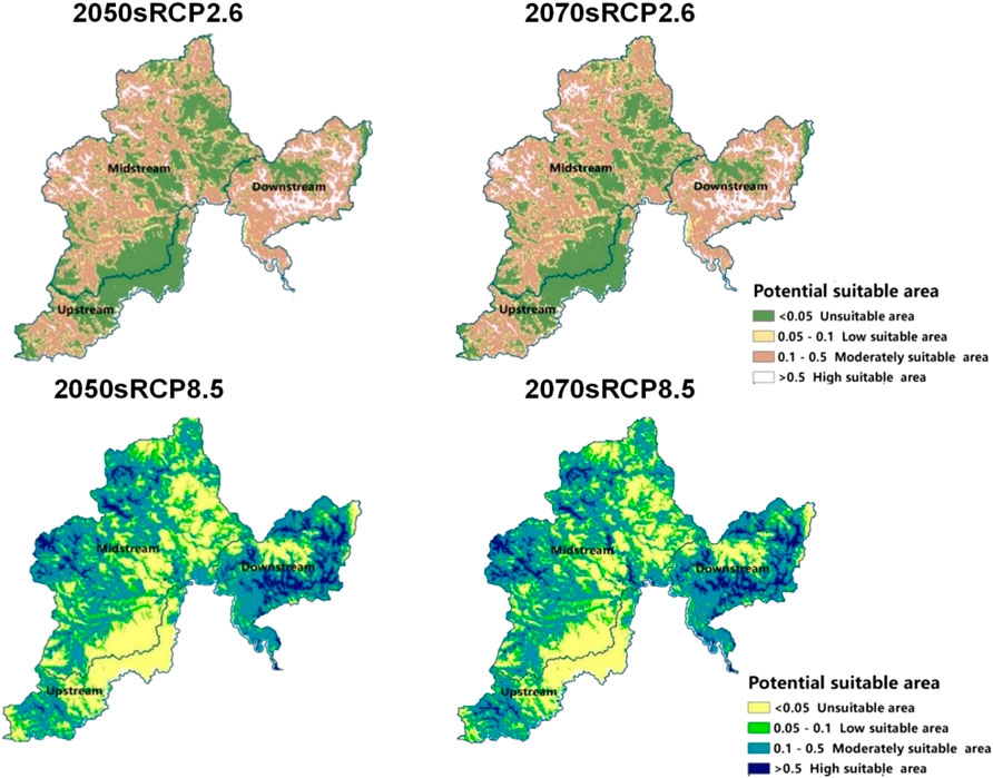
Compared with the current climate, the distribution and area of the fitness zone of D. angustifolia in the 2050’s and 2070’s under the future climate change scenarios are different, according to the MaxEnt model simulation (Figure 5), area change (Table 2), and ArcGIS calculation results. The results show that the predicted future distribution in the 2050’s will be as follows: the non-suitable zone in the TRB will be 8,059.66 km2 (35.64%), the low-suitability zone will be 3,651.75 km2 (16.15%), the medium-suitability zone will be 9,306.55 km2 (41.15%), and the high-suitability zone will be 1,598.17 km2 (7.07%). In the case of high concentration using the RCP8.5 model, the non-suitable zone in the TRB will be 7,759.8 2 km2 (34.31%), the low-suitability zone will be 3,705.58 km2 (16.38%), the medium-suitability zone will be 9,663.0 8 km2 (42.73%), and the high-suitability zone will be 1,487.67 km2 (6.58%).
The results for the predicted future distribution in the 2070s are as follows: the non-suitable area in the TRB will be 7,711.92 km2 (34.10%), the low-suitability area will be 3,704.44 km2 (16.38%), the medium-suitability area will be 9,559.28 km2 (42.27%), and the high-suitability area will be 1,640.51 km2 (7.25%). At the high concentration using the RCP8.5 model, the non-suitable zone in the TRB will be 7,697.22 km2 (34.31%), the low-suitability zone will be 3,685.37 km2 (16.38%), the medium-suitability zone will be 9,599.45 km2 (42.73%), and the high-suitability zone will be 1,634.09 km2 (6.58%). Compared to the current fitness zone, the area of the future fitness zone will also mainly be concentrated in the medium-fitness zone, and the area of the high-fitness zone will slightly decrease, reducing the degree of fragmentation and indirectly leading to a reduced risk of wetland degradation.
Future predicted area change and center of mass shift of Deyeuxia angustifolia in Tumen River Basin
The model simulations (Figure 6 and Table 3) showed that the area of the suitable zone of D. angustifolia in the TRB in the future under both RCP2.6 and RCP8.5 scenarios showed a decreasing trend, and the rate of decrease in the suitable area was greater than the rate of increase. Compared to the original area, using the RCP2.6-RCP8.5 scenario in the 2050s, the unsuitable area showed the same decreasing trend, and was 29.45 km2 (0.13%), and the continuously decreasing area and the same unchanged increasing area were 271.39 km2 (1.2%). In the 2070’s, from RCP2.6 to RCP8.5, the non-tolerant area showed the same decreasing trend and the same continuously increasing area of 88.2 km2 (0.39%), and the same continuous decreasing area and the same unchanged increasing area of 508.86 km2 (1.2%).
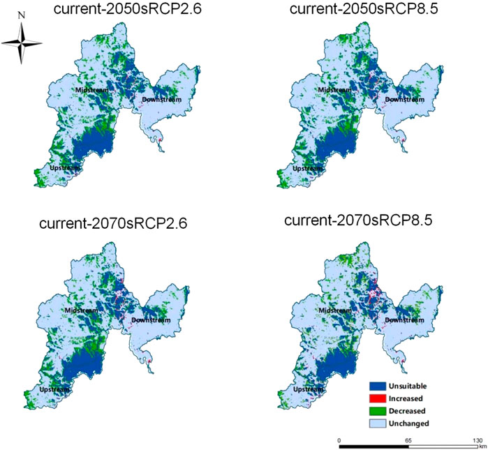
FIGURE 6. Changes of Deyeuxia angustifolia in the suitable area of the Tumen River Basin under different climate change scenarios.
Under the RCP2.6 scenario, the unsuitable area showed a decreasing trend from the 2050’s to the 2070’s of 61.12 km2 (0.27%); the continuous decrease was 287.22 km2 (1.27%). Under the RCP8.5 scenario, the unsuitable area showed the same decreasing trend of 119.87 km2 (0.53%); the continuous decrease was 524.69 km2 (2.32%). Changing RCP2.6-RCP8.5 for different scenarios, the unsuitable area for D. angustifolia showed a decrease and the area of tolerable zones increased. Thus, the increase in temperature will accelerate the growth and spread of D. angustifolia, to some extent. However, the reduction in the area of the tolerant zone was much greater than the increase; therefore, the overall change in the area of the tolerant zone of D. angustifolia was negative.
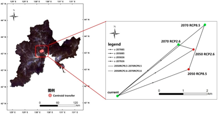
In the climate change scenarios, the fitness zone of D. angustifolia in the TRB shifted to the east. In the 2050’s, the center of mass moved 4.68 km to the northeast in the future RCP2.6 scenario and 3.99 km to the northeast in the RCP8.5 scenario. In the 2070’s it moved 4.19 km to the northeast in the RCP2.6 scenario, 5.93 km to the northeast in the RCP8.5 scenario, and 5.93 km to the northwest in the RCP2.6 scenario. From 2050 to 2070, the center of mass of the fitness zone is predicted to shift 0.83 km in the northwest direction in the RCP2.6 scenario and 2.49 km in the northeast direction in RCP8.5 scenario (Figure 7; Supplementary Table S2).
Analysis of environmental impact factors in Deyeuxia angustifolia suitable area
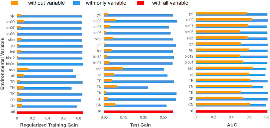
Based on contemporary environmental data, total nitrogen, slope direction, and elevation were found to have a significant influence on the habitat of D. angustifolia, with contribution rates of 23.7%, 20.1%, and 13.1%, respectively. Jackknife analysis was used to determine the importance of the environmental factors in predicting the results. The three variables with the highest regularized training gain, test gain, and AUC values were the slope direction, elevation, and total nitrogen when simulated with individual variables only. The results of the Jackknife analysis showed (Figure 8) that these environmental factors contained valid information that other variables did not have, and had important effects on the current distribution of potentially suitable areas for D. angustifolia. When combining the effects of the model simulations and Jackknife tests, soil factors accounted for 36.0%, climate factors for 16.1%, and topography factors for 47.9% (Supplementary Table S3). Overall, soil and topographic factors were the dominant factors influencing the potential distribution of D. angustifolia.
Discussion
Current distribution of suitable habitats for D. angustifolia
The study results showed that the high-suitability area for the growth of D. angustifolia was distributed in the eastern and western areas of the TRB near the intersection of rivers, forest swamps, and paddy fields. Such areas are more seriously degraded; combined with the spatial changes of wetlands in the TRB between 1976 and 2016, wetlands show an overall trend of shrinkage, with the most serious shrinkage seen in rivers and swamp wetlands, of which swamp wetlands are more degraded. The degradation rate of paddy fields has also increased significantly (Hua 2019), which is consistent with the findings of this study that indicate that wetland degradation will appear first in the high-suitability area of D. angustifolia, such as rivers and forest swamps. Paddy fields are generally subject to greater amounts of human activity due to their proximity to residential areas and rivers, and the rate of degradation is closely related to it (Chen 2008). The high-suitability area of D. angustifolia is greater downstream and decreases upstream because the topography of the TRB is high in the west and low in the east. The west is more prone to soil erosion, which will accelerate the reduction of wetland moisture and intensify degradation (van Lent et al., 2019). The eastern area of the Tumen River is mainly located in Hunchun City in the Yanbian Korean Autonomous Prefecture. The wetland area in this region is extensive, the downstream and midstream show mild degradation, and the upper reaches are subhealthy, which is consistent with the study results (Jin et al., 2019).
Future area change and plastid shift in D. angustifolia
In all future climate scenarios, global climate change greatly affects the distribution of species, leading to the expansion, shifting, and contraction of the fitness zone of populations (Sales et al., 2019). D. angustifolia is more sensitive to the effects of CO2, with high-fitness zones decreasing with increasing CO2 concentrations, indicating that overall, high CO2 concentrations inhibit the growth of D. angustifolia. Mingyi (2015) found that high CO2 concentrations caused a decrease in the internal index of D. angustifolia, which had a significant impact on its ability to carry out photosynthesis and reduced its normal growth rate, which is consistent with the results of this study. The reduction in the area of D. angustifolia over the next 20 years resulted in an increasing trend in wetland area. An improvement in wetland ecosystems may be due to the decline in small-leaved camphor. Conversely, degradation of wetlands may lead to increased infestation of this camphor species. Therefore, changes in small-leaved camphor and wetland development are closely linked and may have a constraining effect on the D. angustifolia species. The increase in wetland area of 1780.83 ha found by Zhang Y. et al. (2020) slowed down the rate of degradation in the area and mitigated the current situation of wetland degradation to some extent. According to different emission scenarios from 2050 to 2070, the overall migration route of the center of mass gradually shifted towards the northeast, which is consistent with the trend of migration of species fitness zones to higher latitudes in the context of global climate change outcomes (Zhang et al., 2018).
Influencing factors affecting the change of suitable habitat in Deyeuxia angustifolia
According to the environmental factors predicted by the model, the most important factor affecting D. angustifolia is total nitrogen, which is one of the factors affecting the species composition, diversity, and nutritional conditions, as the enrichment of nitrogen changes the content of soil nutrients (Fu et al., 2014). Numerous studies have found that the increase in nitrogen promotes the growth of D. angustifolia, increases its productivity, and enhances its competitiveness (Jin et al., 2016), making it a dominant species in the environment, which is consistent with the results obtained in this study. The second dominant factor affecting the growth of D. angustifolia is the slope direction. Found that the disturbance of the slope affects the distribution of vegetation (Shengwei 2014). The third factor is altitude, and D. angustifolia is prone to growing at high altitudes, but is less prevalent at low altitudes, which is consistent with the observations of Luo et al. (2008).
This result is highly consistent with the expectations of this study, after considering anthropogenic improvements as well as restoration of the natural state of the wetland ecosystem. The improvement of the wetlands in the future can also demonstrate the effects of implementing wetland conservation measures and the extremely important role of public intervention. However, the Jackknife analysis showed that, in addition to the great influence of total nitrogen and slope direction on leaflets, the solar radiation in September also had a high rate of influence on the distribution of D. angustifolia, albeit not as high as that of the slope direction. These results indicated that soil warming promoted the growth of D. angustifolia, and, under the same environmental conditions, the higher the heat, the more lush the plant. However, the response of D. angustifolia physiology to soil temperature was more obvious under flooded conditions than under unflooded conditions (Dou et al., 2009). Furthermore, the increase in temperature and decrease in water increased the growth of D. angustifolia and accelerate the degradation of wetlands (Hou et al., 2013). Therefore, D. angustifolia, as a representative plant of wetlands, can provide a basis for research on wetland conservation and utilization, as well as wetland restoration.
Future prospects
In this study, the prediction of the potential distribution of D. angustifolia depends mainly on the data of its distribution points and of the surrounding environmental factors in the TRB. The evaluation of habitat suitability based on these data provides valuable information and theoretical reference for the determination of suitable areas for D. angustifolia in the TRB in the future (Soilhi et al., 2022). The distribution data of D. angustifolia were obtained from actual field vegetation community surveys; however, some distribution points were difficult to reach due to various reasons, which can affect the distribution and number of sampling points. Other environmental factors, such as soil characteristics, topography, land use, and biotic interactions, also impact the potential geographic distribution of the species (Abolmaali et al., 2018) and require multiple validations. This also significantly impacts the improvement of model accuracy owing to the lack of specific requirements on the number of factors and the selection and quantification of human interference factors, such as fast-acting nutrients, enzyme activity, microbial activity, etc. Future studies should consider actual measurement data and other local adaptation and microclimate factors (Ngarega et al., 2021) to improve the accuracy of the model and facilitate better prediction of species distribution models. In addition, RCP of climate change scenarios have low spatial resolution with no standard scale of analysis. Therefore, later stages of these scenarios should be analyzed with more accurate resolution to increase the simulation accuracy. RCPs have been proposed globally by the IPCC and they can represent future climate change under different conditions and scenarios. However, the TRB in this study is located along the borders of China, North Korea, and Russia; thus, future studies should consider reducing the scale of RCP to improve accuracy.
Conclusion
The main objective of this study was to investigate the influence of environmental factors and climate change on the habitat area of D. angustifolia in the TRB, and to provide scientific reference for the degradation range of wetlands and reasonable wetland construction in the TRB. In this study, the MaxEnt model was used to determine the current distribution of the habitat of D. angustifolia and the key environmental factors affecting its distribution, predict the distribution and area changes of the habitat range in future years, accompanied by different future scenarios, and derive the process of the movement of the heart of the habitat range in the TRB. The main findings of the study are as follows:
1) Approximately 2,268.40 km2 (10.03%) of the high-fitness area of D. angustifolia in the TRB is mainly located in the northwestern part of the upper Tumen River, followed by the western part of the middle Tumen River, and the eastern part of the lower Tumen River. These areas are mainly in the eastern and western parts of the TRB, near the intersection of rivers, forest swamps, and paddy fields.
2) The moderately suitable area of D. angustifolia accounted for the main distribution area of the whole TRB area, and the high-suitability area showed an increasing trend with decreasing fragmentation. In the future, the habitat area of D. angustifolia in the TRB under both RCP2.6 and RCP8.5 scenarios will tend to decrease, and the center of mass of the habitat as a whole will move to the east.
3) Soil and topographic factors are the dominant factors influencing the potential distribution of D. angustifolia, among which slope direction, solar radiation in September, and total nitrogen are the three environmental factors that have the greatest influence.
In recent years, owing to the implementation of relevant management measures, the wetland ecological environment has improved, and the degradation area as well as rate have decreased. However, wetland degradation continues to occur every year. Based on the findings of this study, future studies should undertake strict monitoring of the area identify the relevant negative changes in a timely manner, and implement measures to reduce the degradation rate and area, to the maximum possible extent. This is necessary to protect the wetland ecological environment of the TRB and reduce the negative impacts of the increase in species.
Data availability statement
The datasets presented in this article are not readily available because In research. Requests to access the datasets should be directed to Guanglan Cao, Z3VhbmdsYW5jYW9AeWJ1LmVkdS5jbg==.
Author contributions
JZ conducted the investigation, resources, visualization, formal analysis and writing; XJ conducted Investigation, Resources; GC conducted Supervision, Writing review; WZ and RJ conducted Supervision. All authors have read and approved the submitted version
Funding
This work was supported by the National Natural Science Foundation of China under the Key Project (41830643) and the National Science and Technology Basic Resources Survey Project (2019FY101703), as well as the Jilin Provincial Science and Technology Development Program Project (YDZJ202203CGZH023) and the Yanbian University Doctoral Initiation Fund Yanbian University [(2020) No. 36].
Acknowledgments
Thanks to Jilin Provincial Key Laboratory of wetland ecosystem function and ecological security in Changbai Mountain, thanks to GC for her guidance, encouragement and suggestions on this article, WZ for her comments and suggestions on this article, thanks to RJ for his guidance on data processing, and thanks to XJ for her discussion on data.
Conflict of interest
The authors declare that the research was conducted in the absence of any commercial or financial relationships that could be construed as a potential conflict of interest.
Publisher’s note
All claims expressed in this article are solely those of the authors and do not necessarily represent those of their affiliated organizations, or those of the publisher, the editors and the reviewers. Any product that may be evaluated in this article, or claim that may be made by its manufacturer, is not guaranteed or endorsed by the publisher.
Supplementary material
The Supplementary Material for this article can be found online at: https://www.frontiersin.org/articles/10.3389/fenvs.2022.1007662/full#supplementary-material
Abbreviations
TRB, Tumen River Basin; AUC, Area under the curve; RCP, Representative concentration pathway.
References
Abolmaali, S. M. R., Tarkesh, M., and Bashari, H. (2018). MaxEnt modeling for predicting suitable habitats and identifying the effects of climate change on a threatened species, Daphne mucronata, in central Iran. Ecol. Inf. 43, 116–123. doi:10.1016/j.ecoinf.2017.10.002
Brown, J. L. (2014). SDM toolbox: A python‐based GIS toolkit for landscape genetic, biogeographic and species distribution model analyses. Methods Ecol. Evol. 5, 694–700. doi:10.1111/2041-210X.12200
Che, L., Cao, B., Bai, C. K., Wang, J., Zhang, L., et al. (2014). Potential distribution prediction and suitability evaluation of Taibai rice based on MaxEnt and ArcGIS. Bull. Bot. Res. 34 (5), 642–649.
Chen, J. (2008). “Study on the degradation mechanism of paddy ecosystem caused by unreasonable fertilizer application and its restoration effect of fertilizer application [dissertation],” (Changsha, Hunan: Hunan Agricultural University).
Dou, J. X., Liu, J. S., Wang, Y., and Zhao, G. Y. (2009). Effects of simulated soil warming on the growth and physiological characters of Deyeuxia angustifolia. Ying yong sheng tai xue bao 20, 1845–1851.
Fu, X. L., Ma, F., Ni, H. W., and Wang, J. B. (2014) Effects of nitrogen deposition on soil nutrient content of Deyeuxia angustifolia. Adv. Mater. Res., 955. 3655–3660.
Guojun, Q. I., Yan, G. A. O., and Dechao, H. (2012). Invasive dispersal dynamics and fitness analysis of rice weevil in China based on Maxent. J. Plant Prot. 39, 129–136.
Hongwei, N. I., Xing, Z., and Li, J. (1998). Above-ground biomass dynamics of typical meadow populations of little leaf, in the Sanjiang Plain. J. Plant Res. 03, 72–79.
Hou, C., Song, C., Li, Y., Wang, J., Song, Y., and Wang, X. (2013). Effects of water table changes on soil CO2, CH4 and N2O fluxes during the growing season in freshwater marsh of Northeast China. Environ. Earth Sci. 69, 1963–1971. doi:10.1007/s12665-012-2031-2
Hua, C. (2019). “Study on spatial and temporal distribution characteristics and driving forces of wetland degradation in Tumen River Basin [dissertation],” (Yanbian University).
Jessica, B. S., Christine, R. W., and Karen, V. R. (2014). Developing macro habitat models for bats in parks using maxent and testing them with data collected by citizen scientists. Int. J. Biodivers. Conserv. 6, 171–183. doi:10.5897/IJBC2013.0647
Jin, Y., Xu, J., Wang, Y., Wang, S., Chen, Z., Huang, X., et al. (2016). Effects of nitrogen deposition on tundra vegetation undergoing invasion by Deyeuxia angustifolia in Changbai Mountains. Chin. Geogr. Sci. 26, 99–108. doi:10.1007/s11769-015-0746-1
Jin, Z. (2019). “Comprehensive assessment of the water-holding function of wetland ecosystems in the Tumen River basin [dissertation],” (Yanbian University).
Jin, Z., Weihong, Z., and Ri, J. (2019). Study on wetland ecosystem health evaluation in Tumen River basin, China. Wetl. Sci. 17, 344–351.
Liu, Y., Jin, R., and Zhu, W. (2021). Conversion of natural wetland to farmland in the Tumen River basin: Human and environmental factors. Remote Sens. (Basel). 13, 3498. doi:10.3390/rs13173498
Luo, W., Song, F., and Xie, Y. (2008). Trade-off between tolerance to drought and tolerance to flooding in three wetland plants. Wetlands 28, 866–873. doi:10.1672/07-225.1
Luo-rong, W. A. N. G., Lǜ-yi, M. A., Xi-qun, W. A. N. G., and Sui-chao, H. E. (2007). Seedling techniques of Magnolia wufengensis and M. wufengensis var. multitepala. J. Zhejiang Agric. For. Univ. 24 (2), 242–246.
Lupo, Z., Yuemin, P., Jianling, X., and Youbin, Z. (1991). Calamagrostis angustifolia development and utilization research. Mod. Agric. 04, 10–12.
Mark, P., Zhou, R. C., and Zhang, Y. (1993). Study on aboveground biomass composition and seasonal dynamics of Calamagrostis angustifolia Grassland in Sanjiang Plain. China Grassl. 02, 27–31.
Mingyi, X. (2015). “Simulation of the effect of elevated atmospheric CO2 on photosynthetic properties and molecular mechanisms in Chaparral [dissertation],” (Northeastern Agricultural University).
Ngarega, B. K., Masocha, V. F., and Schneider, H. (2021). Forecasting the effects of bioclimatic characteristics and climate change on the potential distribution of Colophospermum mopane in southern Africa using Maximum Entropy (Maxent). Ecol. Inf. 65, 101419. doi:10.1016/j.ecoinf.2021.101419
Qingliang, L., Yao, L., and Shengzuo, F. (2017). PPrediction of potential suitable cultivation area based on MaxEnt model. J. Nanjing For. Univ. (Nat. Sci. Ed.). 41, 25–29.
Sales, L. P., Ribeiro, B. R., Pires, M. M., Chapman, C. A., and Loyola, R. (2019). Recalculating route: Dispersal constraints will drive the redistribution of amazon primates in the anthropocene. Ecography 42, 1789–1801. doi:10.1111/ecog.04499
Shengwei, Z. (2014). “Vegetation changes and mechanisms in the subalpine tundra zone of Changbai Mountain [dissertation],” (Northeast Normal University).
Soilhi, Z., Sayari, N., Benalouache, N., and Mekki, M. (2022). Predicting current and future distributions of Mentha pulegium L. in Tunisia under climate change conditions, using the MaxEnt model. Ecol. Inf. 68, 101533. doi:10.1016/j.ecoinf.2021.101533
van Lent, J., Hergoualc’h, K., Verchot, L., Oenema, O., and van Groenigen, J. W. (2019). Greenhouse gas emissions along a peat swamp forest degradation gradient in the Peruvian amazon: Soil moisture and palm roots effects. Mitig. Adapt. Strateg. Glob. Chang. 24, 625–643. doi:10.1007/s11027-018-9796-x
Wang, R., Jiang, C., Liu, L., Shen, Z., Yang, J., Wang, Y., et al. (2021). Prediction of the potential distribution of the predatory mite Neoseiulus californicus McGregor in China using MaxEnt. Glob. Ecol. Conserv. 29, e01733. doi:10.1016/j.gecco.2021.e01733
Xiao-Ge, X., Tong-Wen, W., and Jie, Z. (2013). Introduction of CMIP5 experiments carried out with the climate system models of Beijing Climate Center. Adv. Clim. Change Res. 4, 41–49. doi:10.3724/SP.J.1248.2013.041
Xuemei, J. (2019). “A study on the potential distribution of plant diversity and small-leaved chapter in wetlands of Yanbian Prefecture [dissertation],” (Yanbian University).
Yang, C. H. P., Zhao, X., and Wang, J. W. (2020). Potential distribution areas of long-footed Kiwifruit in China and their response to climate change based on MaxEnt model. J. Sichuan Agric. Univ. 38, 755–763.
Ye, X. M., Chen, F. S., and Sun, R. X. (2019). Prediction of potential suitable distribution areas for Choerospondias axillaris based on MaxEnt model. Acta Agric. Univ. jiangxiensis. 41, 440–446.
Yixin, D. (2021). “Simulation of landscape evolution dynamics in the little xinganling marsh wetland [PhD thesis],” (Harbin: Harbin Normal University).
Zhang, H., Zhao, H., and Wang, H. (2020). Potential geographical distribution of Populus euphratica in China under future climate change scenarios based on Maxent model. Acta Ecol. Sin. 40 (18), 6552–6563.
Zhang, K., Yao, L., Meng, J., and Tao, J. (2018). Maxent modeling for predicting the potential geographical distribution of two peony species under climate change. Sci. Total Environ. 634, 1326–1334. doi:10.1016/j.scitotenv.2018.04.112
Zhang, L., Jing, Z., Li, Z., Liu, Y., and Fang, S. (2019). Predictive modeling of suitable habitats for Cinnamomum Camphora (L.) presl using maxent model under climate change in China. Int. J. Environ. Res. Public Health 16 (17), 3185. doi:10.3390/ijerph16173185
Zhang, X., Mao, R., Gong, C., Qiao, T., and Song, C. (2014). CO2 evolution from standing litter of the emergent macrophyte Deyeuxia angustifolia in the Sanjiang Plain, Northeast China. Ecol. Eng. 63, 45–49. doi:10.1016/j.ecoleng.2013.12.002
Zhang, Y., Jin, R., Zhu, W., Zhang, D., and Zhang, X. (2020). Impacts of land use changes on wetland ecosystem services in the Tumen River basin. Sustainability 12, 9821. doi:10.3390/su12239821
Zhao, Y., Liao, J., Bao, X., and Ma, M. (2021). Soil seed bank dynamics are regulated by bird diversity and soil moisture during alpine wetland degradation. Biol. Conserv. 263, 109360. doi:10.1016/j.biocon.2021.109360
Zheng, X. J., Sun, P., Zhu, W. H., Xu, Z., Fu, J., Man, W. D., et al. (2017). Landscape dynamics and driving forces of wetlands in the Tumen River Basin of China over the past 50 years. Landsc. Ecol. Eng. 13 (2), 237–250. doi:10.1007/s11355-016-0304-8
Zhou, R. C., Wang, H. T., and Ni, H. W. (1992). Study on wet grassland in Sanjiang Plain. Land Nat. Resour. Res. 01, 43–47.
Keywords: Deyeuxia angustifolia, Wetlands, suitability zones, maxent model, Tumen River Basin
Citation: Zong J, Cao G, Jin X, Jin R and Zhu W (2022) Potential distribution prediction of Deyeuxia angustifolia in the Tumen River Basin and analysis of major impact factors. Front. Environ. Sci. 10:1007662. doi: 10.3389/fenvs.2022.1007662
Received: 30 July 2022; Accepted: 01 September 2022;
Published: 15 September 2022.
Edited by:
Chuanyu Gao, Northeast Institute of Geography and Agroecology, (CAS), ChinaReviewed by:
Guodong Wang, Northeast Institute of Geography and Agroecology, (CAS), ChinaChunguang He, Northeast Normal University, China
Copyright © 2022 Zong, Cao, Jin, Jin and Zhu. This is an open-access article distributed under the terms of the Creative Commons Attribution License (CC BY). The use, distribution or reproduction in other forums is permitted, provided the original author(s) and the copyright owner(s) are credited and that the original publication in this journal is cited, in accordance with accepted academic practice. No use, distribution or reproduction is permitted which does not comply with these terms.
*Correspondence: Guanglan Cao, Z3VhbmdsYW5jYW9AeWJ1LmVkdS5jbg==
 Jin Zong
 Guanglan Cao
 Xuemei Jin3
 Ri Jin