Optimization of a flood diversion gate scheme in flood storage and detention areas based on flood numerical simulation
- 1College of Water Conservancy Engineering, Tianjin Agricultural University, Tianjin, China
- 2State Key Laboratory of Hydraulic Engineering Simulation and Safety, Tianjin, China
Flood storage and detention areas are an important aspect of the river flood control system and an effective measure to ensure flood control safety and mitigate disasters in key areas. Using the flood storage and detention area of DaHuangPuWa as an example, the flood diversion evolution of different positions on the Jinbao highway was simulated numerically. The water level, velocity, and flow rate of each observation point during the 100-year flood were calculated. After comprehensive analysis, it is determined that the location of the diversion gate in the flood storage and detention area is better at the diversion gate of Liuwanzhuang. The results of this paper show that the numerical simulation method can provide more scientific and reasonable theoretical support for the design of flood diversion gates in flood storage and detention areas.
1 Introduction
Floods are a serious natural disaster risk in China. When encountering over-standard floods, flood storage measures can be used to sacrifice the local area to preserve the greater area, store the excess floods in a planned manner, minimize the flood disasters in the planned storage subdistrict, and ensure the safety of the key areas. The design of the flood diversion gate is also very important, in addition to the application timing, when the flood storage area is used. If the location is not reasonably selected, it will affect the flood diversion effect and cause significant losses.
Many scholars at home and abroad have obtained more results in the study of the use of flood storage and detention areas. Zhou Chaohong and Chang Shouquan (2003) used regression analysis and linear programming methods to optimize the design of flood diversion gates in West Qilihai, Tianjin (Zhou and Chang, 2003). Gao Xueping et al. (2004) calculated the maximum water storage volume that could be achieved by adjusting the operation of the flood diversion gate using a numerical model of nonconstant flow in a one-dimensional river network for the specific situation of the Yongding River (Gao et al., 2004). Ye Jiye et al. (2005) analyzed and researched the location of the planned flood gates in the Cuijiaqiao flood storage and detention area, which plays a vital role in the reasonable and effective scheduling of floods in the Huan River and in reducing the inundation losses in the Cuijiaqiao flood storage and detention area (Ye et al., 2005). Li Chuanzhe et al. (2006) applied the GIS-based analytic hierarchy process to the decision of the activation sequence of flood storage and detention areas (Li et al., 2006). Chen Jun et al. (2008) developed a hybrid mathematical model that can simulate the flood diversion gate spreading width and brushing depth and applied the model to the calculation of actual flooding areas (Chen et al., 2008). Zhang Jiantao et al. (2010) proposed in their study of the super standard flooding of the Chaobai River in Beijing that the selection of the flood diversion gate is crucially and directly related to whether floods can be divided and the size of the flood volume (Zhang et al., 2010). Yang Fangli et al. (2011) made a preliminary simulation of the flood level changes of the Han River and the Yangtze River main streams and the flood evolution and inundation process of each flood diversion area after the implementation of flood diversions such as the Dongjinghe flood diversion Minwan and Dujiatai flood storage areas. Based on the basic control equations of two-dimensional nonconstant flow (Yang et al., 2011), Li Daming et al. (2011; 2015; 2016) established a mathematical model of flood evolution using the finite volume method and applied the numerical model to model the flood evolution process at different flood diversion gates, and the application of the harnessed flood evolution model in the joint flood control of flood storage and stagnant floodplain was studied (Li et al., 2011; Li et al., 2015; Li et al., 2016). Liu Zhanyou et al. (2012) established a two-dimensional hydrodynamic model and performed two-dimensional flood evolution calculations to analyze the flood evolution process of the DaHuangPuWa detention area under distinct flood division conditions and proposed zoning activation by selecting DaHuangPuWa as an example (Liu et al., 2012). Yu Haiyan et al. (2013) used a one- and two-dimensional nested nonconstant flow flood evolution mathematical model to study the effect of the ground settlement on flood control and scheduling in the Yongding River (Yu et al., 2013). Wang Caihong et al. (2012) calculated and examined the process of change of the weir flow discharge coefficient and inundation coefficient of the flood diversion gate using a planar two-dimensional mathematical model (Wang et al., 2012). Han Yuling (2013) suggested scientific, economical, and acceptable ideas for the building of the flood storage area and proposed a design scheme suitable for engineering applications through the comparison of design. By numerically simulating various incoming flows (Han, 2013), Fan Yu et al. (2014) were able to determine the timing of water level activation and inundation of flood gates within the floodplain, establishing a theoretical foundation for flood control and scheduling in the floodplain (Fan et al., 2014). Chen Jian et al. (2014) established a mathematical model of flood evolution in a typical river section in the lower reaches of the Yellow River based on MIKE21 to study the influence of the scheduling method of the flood separation zone and the location of the flood diversion gate on the flood control of the river section (Chen et al., 2014). Liu Enjie and Liu Longlong (2015) discussed the determination of the location of the flood diversion gate in the stagnant zone by comparing and analyzing two schemes (Liu and Liu, 2015). Liu Wenbiao and Sun Min (2015) studied the analysis and selection of flood diversion gate design schemes for the Kang Mountain flood storage and detention area (Liu and Sun, 2015). Wang Zhizong et al. (2015) derived calculation modules for coupled river branching points, joint scheduling of gate and dam groups, and throughput floods in flood storage areas and selected Horton’s infiltration formula as the river infiltration simulation method to construct a river network flood simulation model by considering river infiltration (Wang et al., 2015). Xu Boda (2016) used MIKE flood analysis software to study the correlation between flood gate opening width and flood level and flow rate in the Langouwa flood storage area (Xu, 2016). Wang Tian and Song Chen (2016) elaborated on the selection of floodgate sites and the method of selecting floodgate types in the Pangtoupao flood storage and detention area (Wang and Song, 2016). Li Shi et al. (2020) planned the road in the flood storage area based on the flood risk and concluded that the road construction scheme had the least economic loss caused by floods when the road was laid out in the DaHuangPuWa detention area (Li et al., 2020). Wang Zhixing et al. (2019) used a combination of mathematical model calculations and physical model tests to study the discharge capacity of the Laolongkou floodgate and its influencing factors (Wang et al., 2019). Wu Binbin et al. (2019) established a one- and two-dimensional coupled hydrodynamic model considering dynamic infiltration and explored the influence of infiltration on river flooding, flood diversion in storage and detention areas, and the flood evolution process (Wu et al., 2019). Yang Jie et al. (2020) constructed a three-dimensional numerical analysis model for the wrapping project of a flood diversion gate based on floodgate design information and analyzed the deformation law of the floodgate (Yang et al., 2020). In this paper, Li Lingling (2019) used the MIKE21 method to simulate and calculate flood inundation in the Shengzhuangwa flood storage area under different working conditions and compared the calculation results from three aspects: inundation depth, flood arrival time, and inundation duration (Li, 2019).
The Jinbao Highway (Jiuyuan Highway–Wuning Highway segment), which is proposed to be built in Tianjin and is located in Zone III of the DaHuangPuWa flood storage and detention area, is given an appropriate flood diversion gate in this study. A two-dimensional nonconstant flow mathematical model is created for the DaHuangPuWa flood storage area to solve the flood evolution process using hydrodynamic simulation. Combining the flood storage area’s real operation can deliver a great placement for the flood gates.
2 Regional situation
2.1 Physical geography
This paper investigates the application of numerical simulation of flood evolution in the design of flood diversion gates in flood storage and detention areas, taking the DaHuangPuWa flood storage and detention area as an example. It is located on the right bank of the Qinglongwan River at the junction of Wuqing, Baodi, and Ninghe in Tianjin, with a total area of 272.5 km2.
2.2 Flood storage area partition situation
The DaHuangPu flood storage and detention area is divided into Ⅰ, Ⅱ, Ⅲ, Ⅳ, and Ⅴ by the dikes of the Liuhe Main Channel, Sewage Cleaning Channel, Daer Road, Jiuyuan Road, and Xiduzhuang Main Channel, among which Ⅰ and V are divided by Daer Road; Ⅰ and Ⅱ are divided by the left dike of the Liuhe Main Channel; Ⅰ and Ⅲ are divided by the north dike of the Yandu Drainage Canal; Ⅲ and Ⅴ are divided by Jiuyuan Road and Daer Road; Ⅲ and Ⅳ are divided by the north dike of the Sewage Cleaning Channel. The zoning area is shown in Table 1 and Figure 1.
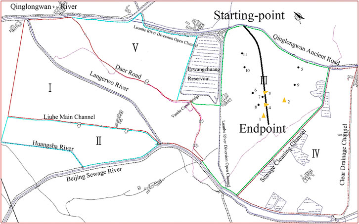
FIGURE 1. Partition map of the Da Huang Pu flood storage and detention area. To illustrate the locations of 11 observation points, we use Photoshop for image processing. The DaHuangPu flood storage and detention area is divided into Ⅰ, Ⅱ, Ⅲ, Ⅳ, and Ⅴ by the dikes of the Liuhe Main Channel, Sewage Cleaning Channel, Daer Road, Jiuyuan Road, and Xiduzhuang Main Channel, among which Ⅰ and V are divided by Daer Road.
The terrain in the DaHuangPu flood storage and detention area is low and flat, and the geomorphological unit belongs to the eastern part of the North China Plain. The topography of the area is flat, with high elevation in the northwest and low elevation in the southeast, approximately 3.20 m (1985 national elevation benchmarks, same below) in the north and 1.20 m in the south. Water accumulates in the area year round, with fishponds, reed ponds, ditches and channels, including the Liuhe Main Channel, Langerwo River, the diversion of water from the open channel of the Luanhe River, the clearing channel, the Qing Pai channel and other channels passing through the area. The elevation of the outer boundary of the flood storage area is high, including the top of the embankment of the Port North embankment, which ranges from 3.9 to 8.0 m; the top of the left embankment of the Huangsha River, which ranges from 3.7 to 4.3 m; the top of the left embankment of the Liuhe Main Channel, which ranges from 3.90 to 4.10 m; the top of the right embankment, which ranges from 3.69 to 4.30 m; the top of the left embankment of the Beijing Sewage River, which ranges from 5.0 to 5.7 m; and the top of the left embankment of the Langerwo River, which ranges from 3.0 to 4.8 m.
3 Principles of flood evolution model for flood storage and detention areas
3.1 Principles of model-calculation
3.1.1 Methods
A one-dimensional mathematical model was used to simulate the water flow described by a one-dimensional system of Saint-Venant equations. These equations were numerically discretized using a four-point linear implicit difference format and solved numerically using the chasing method.
We used Photoshop for image processing.
3.1.2 Two-dimensional flood modeling
The flooding area is simulated using a two-dimensional mathematical model, and the flooding in the two-dimensional area is described by the two-dimensional shallow water equations of motion. The hydrodynamic module in DELFT3D is built based on the Navier–Stokes equations. Control equations in this coordinate system are solved discretely using the alternating direction method (ADI). In the orthogonal curvilinear coordinate system of
Continuity equation of integration along with water depth:
The momentum equation in the direction of
3.2 Handling of contacts
3.2.1 Principles of calculation
The connection mainly refers to the river and the two-dimensional calculation area to control the movement of water weirs, gates and river flood gates. The overflow of the connection satisfies the weir flow formula in hydraulics. Take the broad crest weir as an example to illustrate the following.
The water flow on the broad crest weir is divided into two flow states, free outflow and submerged discharge, and different flow states use different calculation formulas.
Free outflow:
Submerged discharge:
where B is the length of the weir in m,
The weir flow equation is linearly discretized and solved using an iterative method.
By discretizing the above equations, we can obtain the linear relationship between the water level in the river cross-section and discharge, the discharge and upstream and downstream water levels in the connection, and the discharge and water level between adjacent units in the two-dimensional river area. By associating with the boundary conditions, we can obtain a complete set of linear algebraic equations about the nodal water level. The equations can be obtained after solving the equations by the matrix identification method for the river cross-section, connection, water level, flow rate, and flow velocity of the two-dimensional area unit. The highest water level, maximum flow velocity, and flow direction of each node in the two-dimensional calculation area and the flow rate over the gate (weir) and other results can be obtained.
3.2.2 Generalization preprocessing
When the floodwater is divided in the DaHuangPuWa flood storage and detention area and the floodgate is raised, the water does not spread directly after passing through the gate from the QingLongwan River. However, it flows from north to south along the main channel of the Langerwo River and after the water leaves the channel, it spreads to both sides along with the gaps of the embankments on both sides of the Langerwo River. To accurately simulate the flow of floodwater in the river and its spreading to both sides, the size of the calculation grid must be smaller than the width of the main channel. In addition, the number of flood gates between each district is large, and the width is narrow, only 100–300 m, so the accurate simulation of the flood separation process also requires the calculation grid to be smaller than the gate width. Therefore, the DaHuangPu flood control area is divided into 98,000 grids, and the grid length is 50–80 m. The grid refinement improves the calculation accuracy and can more accurately simulate the water flow in the local area.
3.2.3 Model verification
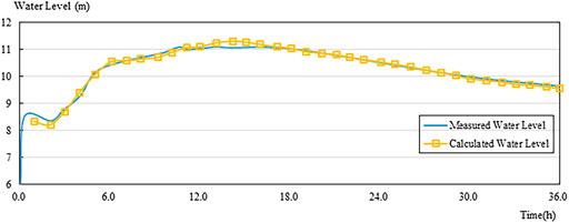
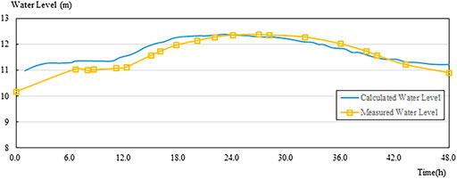
The flood evolution model of the DaHuangPuWa flood storage and detention area covers the 93 km section of the Qinglongwan Jian River from the lower section of the TumenLou gate. To make the model more representative, two floods in 1975 and 1984 were selected for validation. From the validation results, the simulated process of the two floods matched the measured flood process line, and the difference between the maximum value of the water level in 1975 was 0.2 m, with an overall relative error of 2%. The difference between the maximum value of the flood in 1984 was 3 h, and the difference between the maximum value of the flood water level was 0.02 m. The validation results showed that the calculation results of the model and the actual error were within the allowed range. (Figure 2 and Figure 3).
4 Determination of flood diversion gate position in flood storage and detention area
According to the “Report on Flood Control Planning of the North Three Rivers System”, when the upstream volume of the Qinglongwan Jian River exceeds 900 m3/s or when the water level of the Qinglongwan Jian River reaches 6.937 m (1985 national elevation benchmarks) at the floodgate of Langerwo and the water continues to rise, the flood will be diverted to the DaHuangPuWa detention area after approval by opening the floodgate of Langerwo. The principle of zoning flood control is applied to the puddle, and the order of flood control is according to the order of Ⅰ to Ⅴ. The water will be retreated into the Beijing Sewage River using the discharge gates of Chenzhaozhuang and Dongwangzhuang and will enter the sea through the Yongdingxin River.
4.1 Flood diversion gate location scheme
The Jinbao Highway is located in the DaHuangPuWa flood storage and detention area. Once flooding in the flood storage and detention area is underway, it may be blocked by the highway and cause poor flood distribution, so it is necessary to reserve the flood gate as a flood channel. After passing through the flood gate of the Jiuyuan Highway, the flood water in area III of the DaHuangPuWa flood storage and detention area is blocked by the Jinji Highway when it travels from west to east. The first flood passage that the water reaches in the process of travel is the Erwangzhuang Bridge, so the discharge is the largest here.
After the flood evolution calculation, it can be seen that the mainstream direction of flood water after passing through the Erwangzhuang Bridge is roughly perpendicular to the Jinji Highway and is located between Fengjiazhuang and Liuwanzhuang. As the proposed Jinbao Highway is almost parallel to the Jinji Highway, scheme 1 sets the gate near Liuwanzhuang corresponding to the flood channel of the Jinji Highway. The line between the Erwangzhuang Bridge and the flood diversion gate is perpendicular to the highway. However, the terrain here is relatively high, and the flood diversion gate is too close to the drainage channel’s south side, which is unfavorable to flood distribution. The water flow may also cause some impact on the drainage channel embankment.
Scheme 2 is to choose the diversion gate at the Jingjiazhuang flood diversion gate approximately 1 km north of the Liuwanzhuang flood diversion gate, which has the advantage of relatively low terrain and no obstruction after flood diversion. However, it is far from the Erwangzhuang Bridge and the floodway of the Jinji Highway. It is located at the backwater of Fengjiazhuang and Jingjiazhuang. Hence, the flow conditions of flood diversion are relatively poor.
The two flood outlet schemes are shown in Figure 4.
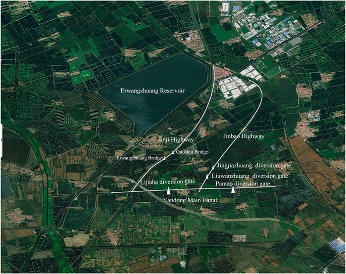
FIGURE 4. Location scheme of flood diversion of the Jinbao Highway. To illustrate the locations of some gates, we use Photoshop for image processing. Scheme 2 is to choose the entrance gate at the Jingjiazhuang flood diversion gate approximately 1 km north of the Liuwanzhuang flood diversion gate, which has the advantage of relatively low terrain and no obstruction after flood diversion. However, it is far from the Erwangzhuang Bridge, the floodway of the Jinji Highway, and is located at the backwater of Fengjiazhuang and Jingjiazhuang. Hence, the flow conditions of flood diversion are relatively poor.
4.2 Observation point selection
The simulation mainly analyzes the evolution of the flood after passing through the reserved flood diversion gate of the Jinji Highway. Therefore, the observation focuses on the triangular area east of Jinji Highway, north of Yandong Main Channel, and west of Qinglongwan Ancient Road, including 7 village observation points of Liuwanzhuang, Fengzhuangzi, Jingjiazhuang, Yujiaheng, Zhengguizhuang, Dongdian and Pantao, as well as four flood diversion gate observation points of Lijiahe, Jingjiazhuang, Liuwanzhuang and Pantao, for a total of 11 observation points.
4.3 Flood evolution calculations
In the flood storage area, while simulating a super standard flood of 100 years, the flood water enters the LangErwo diversion river from the Langerwo gate. It spreads to both sides when the water level exceeds the height of the diversion estuary elevation. The water spreads faster in the diversion river. It reaches the Chenzhaozhuang self-discharge gate after 48 h with an average head flow speed of 0.8 m/s, where the water level at the Chenzhaozhuang point reaches 2.87 m, and zone Ⅰ starts to flood zones Ⅱ and Ⅲ. The flood inundation depth at a particular time node in the process of flood separation was selected (Figure 5).
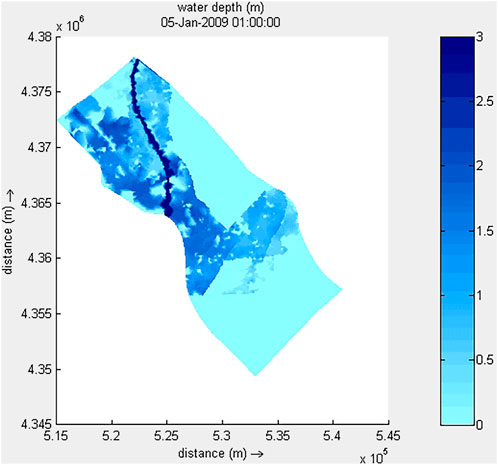
FIGURE 5. Water depth chart of the 100-years flood. In the flood storage area, simulating a super standard flood of 100 years, the flood water enters the LangErwo diversion river from the Langerwo gate. It spreads to both sides when the water level exceeds the height of the diversion estuary elevation. The water spreads faster in the diversion river. It reaches the Chenzhaozhuang self-discharge gate after 48 h with an average head flow speed of 0.8 m/s, where the water level at the Chenzhaozhuang point reaches 2.87 m, and area Ⅰ starts to flood areas Ⅱ and Ⅲ. The flood inundation depth at a particular time node in the process of flood separation was selected.
After the two-dimensional mathematical model analysis, when the 100-year super standard flood occurs, the average water level near the location of the proposed project is 2.85 m, and the minimum height of the roadbed is 3.3 m, which is higher than 2.85 m. The design flood level does not exceed the safe flood protection level of the road section.
4.4 Data analysis
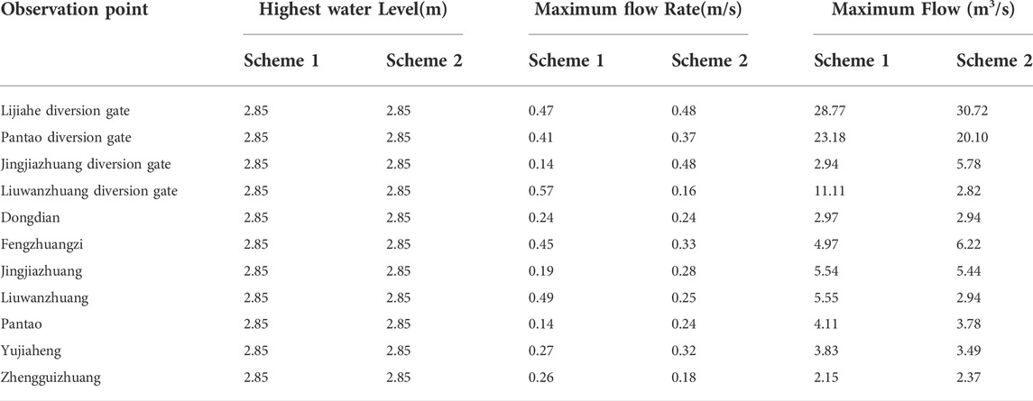
The hydraulic characteristics data of all the observation points under the two flood separation schemes of the Jinbao Highway can be obtained from the numerical model for the 100-year flood. The process line of flow at the floodgate under the two flood separation schemes is typical, which is shown in Figure 6, and the extreme water level, flow velocity, and flow rate of each observation point are shown in Table 2. The results show that the process of flood evolution is basically the same for the two schemes in the numerical simulation of the 100-year flood in the same field. The highest inundation level is the same, and both occur in the stable period of flood storage. The highest flow velocity and maximum flow rate are not significantly different between the two scenarios, and they can effectively divide the flood.
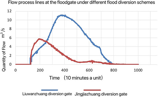
FIGURE 6. Flow process line of flood diversion gate. The hydraulic characteristics data of all the observation points under the two flood separation schemes of the Jinbao Highway can be obtained from the numerical model for the 100-years flood. The process line of flow at the floodgate under the two flood separation schemes is typical.
Meanwhile, the following differences can be derived from the data analysis. First, the flood diversion flow of the Liuwanzhuang flood outlet grows relatively slowly in the early stage, which is more consistent with the results of the previous geographical analysis. Nevertheless, this scheme reduces the upstream flood flow and divides the flood faster from the overall flood diversion period. The overall flood diversion effect is greater than that of the Jingjiazhuang flood outlet. Second, from the geographical location, the Liuwanzhuang flood diversion gate is closer to the Jinji Highway and Erwangzhuang Bridge. The Pantao floodgate of the Yandong Main Channel is closer to facilitate flood flow. It can improve the efficiency of flood diversion. Moreover, the maximum flow velocity of 0.41 m/s will not adversely affect the dike of the Yandong Main Channel.
According to the above analysis, scheme 1 is more reasonable for this project to set the gate near Liuwanzhuang corresponding to the flood channel of the Jinji Highway.
5 Conclusion
By establishing the numerical model, we can obtain detailed data on the flood evolution process and analyze the changes in water level, flow rate, and flow rate at each observation point under the two schemes of Jinbao Highway. We can conclude that Scheme 1, which sets up a flood diversion gate at the location of the Liuwanzhuang floodgate, can meet the design requirements for 100-year flood diversion. It can also meet the flood control requirements of the flood storage and detention area. Meanwhile, the flood diversion effect is better, which can play the role of flood storage and detention area more rapidly and effectively.
The results of this paper show that the numerical simulation method can achieve the design requirements and meet the flood control requirements of the flood storage area. The results of this study show that the numerical simulation method can provide more scientific and reasonable theoretical support for the design of flood gates in flood storage and detention areas.
Data availability statement
The original contributions presented in the study are included in the article/supplementary material, further inquiries can be directed to the corresponding author.
Author contributions
All authors listed have made a substantial, direct, and intellectual contribution to the work and approved it for publication.
Funding
This work was supported by the Scientific Research Program of Tianjin Education Commission (2019KJ038).
Conflict of interest
The authors declare that the research was conducted in the absence of any commercial or financial relationships that could be construed as a potential conflict of interest.
Publisher’s note
All claims expressed in this article are solely those of the authors and do not necessarily represent those of their affiliated organizations, or those of the publisher, the editors and the reviewers. Any product that may be evaluated in this article, or claim that may be made by its manufacturer, is not guaranteed or endorsed by the publisher.
References
Chen, J., Jia, L., Zou, Z. H., and Hou, Y. X. (2014). Flood-control impact of flood diversion area operational methods in lower Yellow River. Eng. J. Wuhan Univ. 47 (3), 336–339. 10.cnki:sun:wsdd.0.2014-03-009.
Chen, J., Zhang, X. F., Tan, G. M., and Tang, H. W. (2008). Numerical simulation of the breach’s expansion and scouring process in flood detention area. J. Sediment Res. 33 (6), 38–44. doi:10.16239/j.cnki.0468-155x.2008.06.007
Fan, Y., Li, D. M., and Zhao, M. Y. (2014). Applied research on flood routing model linked by 1-D and 2-D in Yongding River plains. China Rural Water Hydropower (11), 39–42. doi:10.3969/j.issn.1007-2284.2014.11.012
Gao, X. P., Yu, L. L., Guo, Y. N., Dong, L. X., and Guo, Q. P. (2004). Calculation of water storage in the storing-and-detention area of flood-water Resources utilization of Yongding River. China Rural Water Hydropower (09), 37–39. doi:10.3969/j.issn.1007-2284.2004.09.012
Han, Y. L. (2013). Analysis and comparison of floodgate design options in A flood storage area. Heilongjiang Hydraulic Sci. Technol. 41 (12), 145–147. doi:10.14122/j.cnki.hskj.2013.12.054
Li, C. Z., Yu, F. L., Liu, J., Yan, D. H., Bao, W. F., and Yin, J. G. (2006). Application of GIS analytic hierarchy process for deciding operation sequence of flood detention zones. J. Yangtze River Sci. Res. 23 (5), 48–51+64. doi:10.3969/j.issn.1001-5485.2006.05.013
Li, D. M., Guan, Y. K., Li, L. L., Lv, H. J., and Wang, Q. (2011). Flood routing mathematical model for flood detention basin. Hydro-Science Eng. (3), 27–35. doi:10.16198/j.cnki.1009-640x.2011.03.009
Li, D. M., Wang, X., Zhao, M. Y., Zhang, J. Z., Liu, S. Q., and Liu, J. X. (2015). Flood dispatching numerical simulation for detention basins of Yongding River. J. Tianjin Univ. Sci. Technol. 48 (1), 76–86. doi:10.11784/tdxbz201307063
Li, D. M., Wang, Z. C., Li, Y. Y., Wang, X., Zhang, J. Z., and Liu, J. X. (2016). Research on steering flood routing model and its application in flood combined-regulation. Deten. Basin J. Tianjin Univ. Sci. Technol. 49 (10), 1084–1092. doi:10.11784/tdxbz201409003
Li, L. L. (2019). Flood submergence analysis of Shengzhuangwa flood storage and detention basin based on MIKE21 model. Water Resour. Dev. Manag. 5 (7), 24–28+32. doi:10.16616/j.cnki.10-1326/tv.2019.07.05
Li, S., Qin, Y., Liu, Q., Liu, Z., Cheng, D. J., and Zhao, Y. H. (2020). Research on road planning for flood detention areas based on flood risk management. South-to-North Water Transfers Water Sci. Technol. 18 (3), 81–90. doi:10.13476/j.cnki.nsbdqk.2020.0053
Liu, E. J., and Liu, L. L. (2015). Positioning of flood diversion gate in daming flood retention basin. China Water Resour. (2), 43–45. doi:10.3969/j.issn.1000-1123.2015.02.015
Liu, W. B., and Sun, M. (2015). Analysis and comparison of flood diversion Port gates in kangshan mountain flood detention basin. Water Conservancy Constr. Manag. 9 (4), 25–28. doi:10.3969/j.issn.1005-4774.2015.04.008
Liu, Z. Y., Han, M. A., and Zhao, Y. H. (2012). Analysis of flood routing process in dahuangpuwa detention area. Water Sci. Eng. Technol. (4), 33–35. doi:10.19733/j.cnki.1672-9900.2012.04.011
Wang, C. H., Zhang, X. F., and Lv, S. Y. (2012). A study of submerged coefficient of gate in flood diversion area. China Rural Water Hydropower (4), 130–132+138. 10.cnki:sun:znsd.0.2012-04-038.
Wang, T., and Song, C. (2016). Comparison of floodgate options for the Pangtoupao flood storage area. Heilongjiang Hydraulic Sci. Technol. 44 (5), 98–99. doi:10.14122/j.cnki.hskj.2016.05.032
Wang, Z. X., Guan, G. X., Wang, T. Y., and Ding, C. C. (2019). Analysis of flood discharging capacity of Laolongkou flood-diversionsluice at Pangtoupao flood retarding basin. Hydro-Science Eng. (3), 51–59. doi:10.16198/j.cnki.1009-640x.2019.03.007
Wang, Z. Z., Cheng, L., Wang, Y. T., and Liu, K. L. (2015). Modelling the flood behavior in a river network considering the streambed infiltration and its application in Haihe River basin of China. J. Hydraulic Eng. 46 (4), 414–424. doi:10.13243/j.cnki.slxb.2015.04.005
Wu, B. B., Yu, H. J., Mu, J., Ma, J. M., and Shi, L. (2019). Flood simulation in River and flood storage-detention area considering infiltration. Water Resour. Prot. 35, 68–75. doi:10.3880/j.issn.1004-6933.2019-06-010
Xu, B. D. (2016). Analysis of flood entrance reasonable width in Langouwa detention basin. Water Sci. Eng. Technol. (2), 48–50. doi:10.19733/j.cnki.1672-9900.2016.02.019
Yang, F. L., Zhang, X. F., and Zhang, Y. X. (2011). Application of mathematical model of 1-d river network coupled with 2-D horizontal flood routing. Yangtze River 42 (1), 59–62. doi:10.16232/j.cnki.1001-4179.2011.01.012
Yang, J., Fang, J., Dong, Q. H., Chen, Y. M., and Huang, Y. (2020). Study on the stability of flood diversion gates in erba flood detention basin. Water Resour. Hydropower Eng. 51 (3), 131–136. doi:10.13928/j.cnki.wrahe.2020.03.017
Ye, J. Y., Zheng, E. W., and Zhou, J. J. (2005). The location of floodgate in Cuijiaqiao flood storage and detention area. Henan Water Resour. South-to-North 18 (5), 91–95. doi:10.3969/j.issn.1007-2284.2004.09.012
Yu, H. Y., Wang, J. G., and Fu, K. R. (2013). An analysis of the impact of land subsidence in Yongding River on flood control and countermeasures. China Rural Water Hydropower (10), 151–154. doi:10.3969/j.issn.1007-2284.2013.10.043
Zhang, J. T., Cong, X. H., and Zhao, Y. F. (2010). Study on superstandard flooding of Chaobai River in beijing. Beijing, China: Beijing Water, Vol. 4 (2), 23–25. 10.cnki:sun:bjsl.0.2010-02-011.
Keywords: flood simulation, flood storage and detention area, flood diversion gate, numerical simulation, DaHuangPuWa detention area
Citation: Yu P, Ma H, Qiu L, Zhang T and Li S (2022) Optimization of a flood diversion gate scheme in flood storage and detention areas based on flood numerical simulation. Front. Environ. Sci. 10:978385. doi: 10.3389/fenvs.2022.978385
Received: 26 June 2022; Accepted: 12 July 2022;
Published: 11 August 2022.
Edited by:
Chen Zhang, Tianjin University, ChinaReviewed by:
Guangning Li, China Institute of Water Resources and Hydropower Research, ChinaHang Zeng, Changsha, China
Copyright © 2022 Yu, Ma, Qiu, Zhang and Li. This is an open-access article distributed under the terms of the Creative Commons Attribution License (CC BY). The use, distribution or reproduction in other forums is permitted, provided the original author(s) and the copyright owner(s) are credited and that the original publication in this journal is cited, in accordance with accepted academic practice. No use, distribution or reproduction is permitted which does not comply with these terms.
*Correspondence: Ping Yu, yuping@tjau.edu.cn
 Ping Yu
 Huixin Ma1
