 Luis Gimeno
 Raquel Nieto
 Marta Vázquez
 David A. Lavers
- 1EPhyslab, Departamento de Física Aplicada, Facultad de Ciencias, Universidad de Vigo, Ourense, Spain
- 2IHR-Hydroscience & Engineering, The University of Iowa, Iowa City, IA, USA
Atmospheric rivers (ARs) are narrow regions responsible for the majority of the poleward water vapor transport across the midlatitudes. They are characterized by high water vapor content and strong low level winds, and form a part of the broader warm conveyor belt of extratropical cyclones. Although the meridional water vapor transport within ARs is critical for water resources, ARs can also cause disastrous floods especially when encountering mountainous terrain. They were labeled as atmospheric rivers in the 1990s, and have since become a well-studied feature of the midlatitude climate. We briefly review the conceptual model, the methods used to identify them, their main climatological characteristics, their impacts, the predictive ability of numerical weather prediction models, their relationship with large-scale ocean-atmosphere dynamics, possible changes under future climates, and some future challenges.
Introduction
Atmospheric scientists must consider and study both climatological and meteorological aspects of the transport of moisture in the atmosphere (Gimeno et al., 2012; Gimeno, 2013). It is particularly important to review the conceptual models of moisture transport to aid research into the origin of continental precipitation. The notion of the atmospheric river (AR) is key to the study of water vapor transport in extratropical regions. In this mini-review we summarize the main characteristics of ARs, which are responsible for the transport of large amounts of water along relatively narrow “rivers” across the midlatitudes toward higher latitudes.
What is an AR?
Most of the water vapor transported meridionally across the midlatitudes (>90% of the total midlatitude vertically integrated water vapor flux) takes place through narrow corridors called atmospheric rivers (Zhu and Newell, 1998). These transient filamentary regions occur within the warm conveyor belt (WCB) of extratropical cyclones, and are characterized by high water vapor content and strong low level winds (a low level jet). Although first discovered some time ago (e.g., Namias, 1939; Palmén and Newton, 1969; Browning and Pardoe, 1973) we start our mini-review with the seminal work of Newell et al. (1992), who termed these long (about 2000 km), narrow (about 300–500 km wide) bands of enhanced water vapor flux “tropospheric rivers” (Figure 1). They used the term “rivers” because they transport water at volumetric flow rates similar to those of the world's largest rivers. The word “tropospheric” has since fallen out of favor, and we now use “atmospheric rivers” (ARs, Zhu and Newell, 1998), although there is still some disagreement on the appropriateness of this term, with alternatives being “tropical moisture exports” (Knippertz and Wernli, 2010) or “moisture conveyor belts” (Bao et al., 2006). This last term is thanks to an analogy with the conveyor belt model of extratropical cyclones (Carlson, 1980), in which the WCB is a broader feature of extratropical cyclones that plays a central role in the transport of sensible and latent heat polewards, to balance the contribution of other components of the cyclone that transport relatively cool and dry air equatorwards. ARs also have colloquial names, such as “Hawaiian fire hose,” or “Pineapple Express” (Lackmann and Gyakum, 1999), non-technical terms commonly used by forecasters to refer to ARs that connect tropical moisture near the Hawaiian Islands with the west coast of North America; over the central United States ARs have been named the “Maya Express” (Dirmeyer and Kinter, 2009).
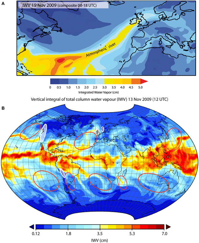
Figure 1. (A) Composite Integrated Total Column of Water Vapor (IWV) between 00 and 18 UTC 19 November 2009 showing an atmospheric river (AR) associated with extreme precipitation events that affected the United Kingdom (UK). Data: ERA-Interim. (B) A general distribution of areas of occurrence of ARs (red contours) based on Waliser et al. (2012) and Zhu and Newell (1998). White contours showed the continental areas where there are reported cases of ARs linked with extreme precipitation and floods (listed in Supplementary Table III).
Structure of an AR: Observation and Modeling
Supplementary Table I lists the key observational and modeling studies concerning the structure of ARs. A typical AR resides within the warm conveyor belt in the pre-cold-frontal region of an extratropical cyclone. Its properties include (Ralph et al., 2004, 2005): (1) a concentrated band of enhanced low-level specific humidity (frontal convergence forces the air to ascend and is responsible for the vertical expansion of this band of enhanced humidity.), (2) a pre-cold-frontal low level jet due to the temperature gradient across the cold front (owing to the thermal wind relationship), and (3) the vertical distribution of the equivalent potential temperature shows moist-neutral stratification in the area of the AR, low-level potential instability on the cold side of the front, and an area of subsidence at low levels ahead of the AR associated with the dry cap on top of the trade wind inversion. The moisture in an AR has two origins (Bao et al., 2006): (1) local moisture convergence along the cold front of the extratropical cyclone, and (2) direct poleward transport of tropical moisture. The different precipitation regimes observed in an AR event include (Matrosov, 2013) “cold” rainfall (mostly formed by ice precipitation above the freezing level for more northern latitudes); “warm” rainfall (limited amounts of ice in precipitation for temperatures above the freezing level); and regions of mixed precipitation with both warm and cold rainfall. These three regimes occur, on average, with equal frequency. Figure 2 illustrates the typical structure and dimensions of an AR.
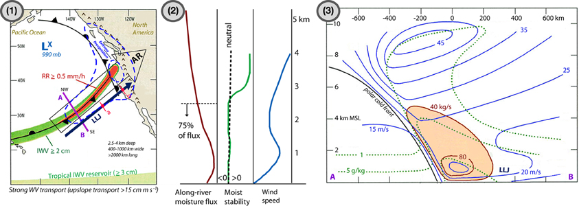
Figure 2. Conceptual model scheme of an atmospheric river (AR) over the northeastern Pacific Ocean. (1) Plan-view schematic showing the relative positions of the polar-cold-front and the Low Level Jet (LLJ). The big arrow shows the AR and the blue one the LLJ. In dark green it is showed the concentrated integrated total column of water vapor (IWV) ≥2 cm and in red the associated rain-rate enhancement (RR) ≥0.5 mm/h along the AR. The broken blue line defines a symbolic area of precipitation associated to the full system. The magenta line A–B defines a cross-section projection for (3). The pink segments over the pre-cold-frontal LLJ (with a–b) marked the limits with profiles for (2) are integrated. At the bottom in light green it is showed the tropical IWV reservoir (>3 cm). (Note that the thresholds are regional in essence and the fact of including values in the text and in the diagram is only with illustrative sense) (2) Vertical structure of moisture flux (in red), moist static stability (in green) and wind speed (in blue) along the LLJ [a–b in (1)]. (3) Cross section schematic through an AR [along A–B in (1)] highlighting the vertical structure of the along front isotachs (blue contours; m/s), water vapor specific humidity (dotted green contours; g/kg), and horizontal along front moisture flux (red contours and shading; ×105 kg/s). This figure is a composition using figures adapted from Figure 23(a) by Ralph et al. (2004) for (1), from Figure 13(b) by Ralph et al. (2005) for (2) and from Figure 23(b) by Ralph et al. (2004) for (3) (American Meteorological Society. Used with permission).
Methods to Identify Atmospheric Rivers
There are two main approaches used to detect ARs: (i) by using Integrated Water Vapor (IWV) from satellite measurements (e.g., Ralph et al., 2004), reanalyses or models (e.g., Dettinger et al., 2011) and then applying criteria on the IWV (in terms of IWV amount, length and width e.g., areas with IWV greater than 2 cm, narrower than 1000 km, and longer than about 2000 km); and (ii) methods that calculate the vertically integrated horizontal water vapor transport (IVT) between 1000 hPa and 300 hPa from atmospheric reanalyses or models (e.g., Zhu and Newell, 1998), and then employ thresholds on IVT to define an AR (e.g., IVT250, which defines an AR as a contiguous region ≥2000 km in length with IVT ≥250 kg m−1 s−1). A summary of the main characteristics of these methods and typical thresholds used in the detection of ARs can be found in Supplementary Table II. A further technique relates to the identification of hydrological extremes, such as extreme precipitation or floods, and then assessing the atmospheric state (e.g., IWV/IVT/specific humidity, and wind fields) to determine whether an AR caused the extremes (e.g., Ralph et al., 2006; Lavers et al., 2011; Neiman et al., 2011).
A Climatological View of ARs
At any time, there are typically three-to-five major conduits in each Hemisphere, each of which transports large amounts of water vapor in narrow streams across the midlatitudes (e.g., Zhu and Newell, 1998). At 35°N, it is estimated that 90% of the total meridional water vapor flux is due to ARs and that these structures cover about 10% of the total hemispheric circumference. Zhu and Newell (1998) related ARs to the Northern Hemisphere winter planetary wave number 4–5, values normally associated with synoptic-scale extratropical cyclones. Climatologically there are more ARs during the winter half-year because of the strong association between ARs and extra-tropical cyclones, which are prevalent in winter. Waliser et al. (2012) produced a global climatology for 2 years (from May 2008 to April 2010) by manual inspection of daily maps using the criteria of IWV from the Atmospheric Infrared Sounder (AIRS) and the criteria of Ralph et al. (2004), and identified a total of 259 ARs (122 in the first year and 137 in the second; Figure 1B). These IWV areas match the areas of high moisture transport from the tropics to the extratropics as found by Knippertz et al. (2013). Waliser et al. (2012) also found that the maximum number of ARs occurred in the northeastern Pacific. In regional studies over longer periods, about 15 landfalling ARs per year were counted in California (Neiman et al., 2008), and on average about 8–10 persistent winter ARs (of at least 18 h duration) affected Great Britain (Lavers et al., 2012). In terms of duration, Ralph et al. (2013b) found that AR conditions lasted an average of 20 h, although the most persistent 10% lasted an average of 40 h with streamflows seven times higher than for the average events.
Impact of Landfalling ARs
ARs clearly have a dual impact in that they are both responsible for hazards and are the main agent of water resources in many coastal regions (Ralph and Dettinger, 2011). When a vapor-rich AR with lower-tropospheric moist neutrality and strong horizontal winds encounters mountainous terrain, the AR is forced upwards, at which point orographic enhancement of rainfall can occur producing extreme precipitation events and catastrophic flooding (e.g., Ralph et al., 2006). At the same time ARs represent a significant source of precipitation for water resources. Guan et al. (2010) and Dettinger et al. (2011) estimated that rainfall delivered by ARs provided 25–50% of California's water supply. Heavy rainfall is the most studied aspect of landfalling ARs, however, and the relationships between ARs and flooding on the US West Coast, the central United States, Europe and South America are well documented. Supplementary Table III lists a comprehensive set of studies linking ARs with heavy rainfall and flooding, indicating both geographical areas and the main impacts. In most of these studies it was shown that the dominant precipitation forcing mechanism is orographic lifting, although other synoptic- and mesoscale processes can play a role both in the intensity of precipitation and the duration of events, such as vertical air motions associated with convection which can intensify precipitation, and mesoscale frontal waves that can increase the duration of AR conditions (Ralph et al., 2011). In any case, the most influential parameters for storm-total precipitation are the strength of the AR (as expressed both as water vapor content and low-level winds), its width, the wind orientation with respect to the mountains, and the movement of the overall AR and cold front. Ralph et al. (2013a) defined thresholds of these parameters, above which extreme precipitation is likely to occur on the US West Coast; this approach could well be used for other regions as well. They found that when IWV exceeds 2 cm and IVT fluxes are greater than 15 cm (m s−1) for more than 32 h, extreme precipitation is likely; additionally if the soil moisture exceeds 35% at representative sites, intense streamflows tend to occur.
Ability of Models to Predict ARs
The important question remains of how well ARs can be represented and predicted by numerical weather prediction (NWP) models. Ralph et al. (2010) showed that NWP models can have large forecasting errors in the landfalling of ARs. An analysis of the ability of a model to identify and predict an AR is possible via its ability to identify and predict the key characteristics of ARs, such as position, water vapor transport, extent, or frequency of occurrence. Wick et al. (2013) assessed the ability of ensemble forecast systems for a region of the Northeast Pacific Ocean from five leading forecasting centers to accurately predict and reproduce the water vapor signature of ARs, AR width, AR strength (IWV content along the AR axis), and position of the AR on reaching land. They found that models were able to forecast the overall presence of ARs, even 10 days beforehand, but the forecasts failed in the timing and position of landfall, particularly for longer lead times.
Large-Scale Ocean-Atmosphere Dynamics and ARs
The connection between occurrence and activity of ARs and large-scale ocean-atmosphere dynamics is very poorly understood. In a single case study (the high-impact AR landfall in the Pacific Northwest during March 2005), Ralph et al. (2011) found that tropical water vapor was entrained in the AR thanks to the successive combination of different planetary-scale phenomena: (1) a Madden-Julian Oscillation (MJO) convective signal initially forming over the tropical Indian Ocean; (2) eastward-propagating Kelvin waves in the tropics; (3) a wave packet (EWP) propagating from western Asia to the Pacific in the extratropics, amplifying ridges and troughs in the eastern Pacific; and (4) deep penetration into the tropics by the EWP, which together with the Kelvin waves favored the uptake of tropical moisture by the AR. Jiang and Deng (2011) found a link between AR activity in the North Pacific and East Asian cold surges (EACS), advances of a polar airmass toward the east coast of the Eurasian continent which enhances extratropical cyclogenesis, and intensifies the amplitudes of atmospheric disturbances ranging from synoptic to sub-seasonal time scales. They found that EACS modulate the daily occurrence probability of ARs over the eastern North Pacific, increasing the daily occurrence probability of ARs near the west coast of the USA by 50% relative to the climatological value. The mechanism takes place via a combination of baroclinic and barotropic disturbances. In the initial phase of an EACS there is a significant poleward moisture transport toward the western North Pacific and Gulf of Alaska because of baroclinic disturbances that develop over these two areas; then, the merging of high frequency troughs favors the development of barotropic disturbances that increase the daily occurrence probability of ARs. Guan et al. (2012) showed that when enhanced convection associated with the MJO was located in the western Pacific, the largest number of high-impact AR landfalls occurred in the Sierra Nevada, and in a subsequent study Guan et al. (2013) found that during the negative phase of Arctic Oscillation (AO) and Pacific/North American (PNA) more winter ARs occurred in California for the period 1998–2011. The estimated increase in ARs during the negative and positive phases (as opposed to their opposite phases) was 90% for the AO and 50% for the PNA. Studies of ARs impacting Britain found a significant negative relationship between winter ARs and the Scandinavian Pattern (SCP; Lavers et al., 2012). In subsequent work covering Western Europe, Lavers and Villarini (2013) found that the North Atlantic Oscillation (NAO) affected AR activity in different parts of Europe; in southern Europe ARs are concurrent with negative NAO phases, whereas in northern Europe a more positive NAO-type pattern is associated with AR occurrence. The roles of the El Niño–Southern Oscillation (ENSO) and the Pacific Decadal Oscillation (PDO) are still unclear, although Bao et al. (2006) hypothesized that because the direct poleward transport of tropical moisture within an AR is most likely during the neutral ENSO phase and least likely during the El Niño phase, at least in the Pacific, ARs should be less frequent during the El Niño phase. Dettinger (2004) suggested that ARs are most pronounced during warm PDO (i.e., El Niño-like) and neutral/near-neutral ENSO conditions.
Atmospheric Rivers in a Changing Climate
Understanding the possible changes in the frequency and intensity of ARs in future climates is of considerable importance. Changes in the number or intensity of ARs could affect the frequency and magnitude of flooding in a changing climate. It is possible that AR frequency will alter due to changes in the storm track (Ulbrich et al., 2008), and AR intensity is likely to increase because of an increase in atmospheric moisture in a warmer climate. This is because atmospheric water vapor content is expected to rise due to higher temperatures in line with the Clausius–Clapeyron equation. Two studies have been published along these lines, one on ARs for California (Dettinger, 2011), and the other for Europe (Lavers et al., 2013). In the Californian study seven climate models were used, and the results suggest that the risk of flooding (associated with ARs) in a future climate will increase because of increased water vapor transport within ARs, more years with high AR frequency, and an increase in the length of the AR season. All the evidence for California points toward an enhanced flood risk from ARs. In the European study, results from five state-of-the-art global climate models (GCMs) in the fifth Climate Model Intercomparison Project (CMIP5) show a greater number and intensity (increased IVT) in North Atlantic ARs, possibly leading to an increase in the frequency and magnitude of flood events. An extreme result is the doubling of the frequency of ARs for the high emissions scenario (RCP8.5) for 2074–2099.
Conclusions
The main advantage of the AR conceptual model is its ability to link intense atmospheric transport of moisture across the midlatitudes with heavy precipitation events. There are plenty of articles in the scientific literature in which strong relationships are shown between ARs and flooding in the midlatitudes, (e.g., western North America, South America, the Norwegian coast and the British Isles). Another important advantage is that the AR model is simple, intuitive, and easy to visualize, allowing simple computations on AR positions, changes, and regional and global contributions of ARs to the hydrological cycle. Finally, the model has the power to attribute major socioeconomic losses to a meteorological phenomenon that is responsible for many of the largest winter floods in the midlatitudes.
Conflict of Interest Statement
The authors declare that the research was conducted in the absence of any commercial or financial relationships that could be construed as a potential conflict of interest.
Acknowledgments
The authors would like to thank the Spanish Government, which funded this work through the TRAMO project (cofounded by FEDER).
Supplementary Material
The Supplementary Material for this article can be found online at: http://www.frontiersin.org/journal/10.3389/feart.2014.00002/abstract
References
Bao, J. W., Michelson, S. A., Neiman, P. J., Ralph, F. M., and Wilczak, J. M. (2006). Interpretation of enhanced integrated water vapor bands associated with extratropical cyclones: their formation and connection to tropical moisture. Mon. Wea. Rev. 134, 1063–1080. doi: 10.1175/MWR3123.1
Browning, K. A., and Pardoe, C. W. (1973). Structure of low-level jet streamsahead of midlatitude cold fronts. Q. J. R. Meteorol. Soc. 99, 619–638. doi: 10.1002/qj.49709942204
Dettinger, M. (2011). Climate change, atmospheric rivers, and floods in California—A multimodel analysis of storm frequency and magnitude changes. J. Amer. Water Resour. Assoc. 47, 514–523. doi: 10.1111/j.1752-1688.2011.00546.x
Dettinger, M. D. (2004). Fifty-two years of pineapple-express storms across the west coast of North America. U.S. Geological Survey, Scripps Institution Of Oceanography For The California Energy Commission, Pier Energy-Related Environmental Research. CEC-500-2005-004. Available online at: http://www.energy.ca.gov/2005publications/CEC-500-2005-004/CEC-500-2005-004.PDF
Dettinger, M. D., Ralph, F. M., Das, T., Neiman, P. J., and Cayan, D. R. (2011). Atmospheric rivers, floods and the water resources of California. Water 3, 445–478. doi: 10.3390/w3020445
Dirmeyer, P. A., and Kinter, J. L. (2009). The maya express—late spring floods in the U.S. Midwest. Eos. Trans. Amer. Geophys. Union 90, 101–102. doi: 10.1029/2009EO120001
Gimeno, L. (2013). Grand challenges in atmospheric science. Front. Earth Sci. 1:1. doi: 10.3389/feart.2013.00001
Gimeno, L., Stohl, A., Trigo, R. M., Dominguez, F., Yoshimura, K., Yu, L., et al. (2012). Oceanic and terrestrial sources of continental precipitation. Rev. Geophys. 50, RG4003. doi: 10.1029/2012RG000389
Guan, B., Molotch, N. P., Waliser, D. E., Fetzer, E. J., and Neiman, P. J. (2010). Extreme snowfall events linked to atmospheric rivers and surface air temperature via satellite measurements. Geophys. Res. Lett. 37, L20401. doi: 10.1029/2010GL044696
Guan, B., Molotch, N. P., Waliser, D. E., Fetzer, E. J., and Neiman, P. J. (2013). The 2010/2011 snow season in California's sierra nevada: role of atmospheric rivers and modes of large-scale variability. Water Resour. Res. 49, 6731–6743. doi: 10.1002/wrcr.20537
Guan, B., Waliser, D. E., Molotch, N. P., Fetzer, E. J., and Neiman, P. J. (2012). Does the Madden-Julian Oscillation influence wintertime atmospheric rivers and snowpack in the Sierra Nevada? Mon. Wea. Rev. 140, 325–342. doi: 10.1175/MWR-D-11-00087.1
Jiang, T., and Deng, Y. (2011). Downstream modulation of North Pacific atmospheric river activity by East Asian cold surges. Geophys. Res. Lett. 38, L20807. doi: 10.1029/2011GL049462
Knippertz, P., and Wernli, H. (2010). A Lagrangian climatology of tropical moisture exports to the Northern Hemispheric extratropics. J. Climate 23, 987–1003. doi: 10.1175/2009JCLI3333.1
Knippertz, P., Wernli, H., and Gläser, G. (2013). A global climatology of tropical moisture. J. Climate 26, 3031–3045. doi: 10.1175/JCLI-D-12-00401.1
Lackmann, G. M., and Gyakum, J. R. (1999). Heavy cold-season precipitation in the northwestern United States: synoptic climatology and an analysis of the flood of 17–18 January 1986. Wea. Forecast. 14, 687–700.
Lavers, D. A., Allan, R. P., Villarini, G., Lloyd-Hughes, B., Brayshaw, D. J., and Wade, A. J. (2013). Future changes in atmospheric rivers and their implications for winter flooding in Britain. Environ. Res. Lett. 8, 034010. doi: 10.1088/1748-9326/8/3/034010
Lavers, D. A., Allan, R. P., Wood, E. F., Villarini, G., Brayshaw, D. J., and Wade, A. J. (2011). Winter floods in Britain are connected to atmospheric rivers. Geophys. Res. Lett. 38, L23803. doi: 10.1029/2011GL049783
Lavers, D. A., and Villarini, G. (2013). The nexus between atmospheric rivers and extreme precipitation across Europe. Geophys. Res. Lett. 40, 3259–3264. doi: 10.1002/grl.50636
Lavers, D. A., Villarini, G., Allan, R. P., Wood, E. F., and Wade, A. J. (2012). The detection of atmospheric rivers in atmospheric reanalyses and their links to British winter floods and the large-scale climatic circulation. J. Geophys. Res. 117, D20106. doi: 10.1029/2012JD018027
Matrosov, S. Y. (2013). Characteristics of landfalling atmospheric rivers inferred from satellite observations over the eastern North Pacific Ocean. Mon. Wea. Rev. 141, 3757–3768. doi: 10.1175/MWR-D-12-00324.1
Namias, J. (1939). The use of isentropic analysis in short term forecasting. J. Aeronaut. Sci. 6, 295–298. doi: 10.2514/8.860
Neiman, P. J., Ralph, F. M., Wick, G. A., Lundquist, J. D., and Dettinger, M. D. (2008). Meteorological characteristics and overland precipitation impacts of atmospheric rivers affecting the West Coast of North America based on eight years of SSM/I satellite observations. J. Hydrometeor 9, 22–47. doi: 10.1175/2007JHM855.1
Neiman, P. J., Schick, L. J., Ralph, F. M., Hughes, M., and Wick, G. A. (2011). Flooding in western washington: the connection to atmosphericrivers. J. Hydrometeor. 12, 1337–1358. doi: 10.1175/2011JHM1358.1
Newell, R. E., Newell, N. E., Zhu, Y., and Scott, C. (1992). Tropospheric rivers? A pilot study. Geophys. Res. Lett. 19, 2401–2404. doi: 10.1029/92GL02916
Palmén, E., and Newton, C. W. (1969). Atmospheric Circulation Systems: Their Structure and Physical Interpretation. New York, NY: Academic Press.
Ralph, F. M., Coleman, T., Neiman, P. J., Zamora, R. J., and Dettinger, M. D. (2013a). Observed impacts of duration and seasonality of atmospheric-river landfalls on soil moisture and runoff in coastal northern California. J. Hydrometeor. 14, 443–459. doi: 10.1175/JHM-D-12-076.1
Ralph, F. M., Intrieri, J., Andra, D. Jr. Atlas, R., Boukabara, S., Bright, D., et al. (2013b). The emergence of weather-focused testbeds linking research and forecasting operations. Bull. Amer. Meteor. Soc. 94, 1187–1211. doi: 10.1175/BAMS-D-12-00080.1
Ralph, F. M., and Dettinger, M. D. (2011). Storms, floods, and the science of atmospheric rivers. Eos 92, 265–266. doi: 10.1029/2011EO320001
Ralph, F. M., Neiman, P. J., Kiladis, G. N., Weickman, K., and Reynolds, D. W. (2011). A multi-scale observational case study of a Pacific atmospheric river exhibiting tropical–extratropical connections and a mesoscale frontal wave. Mon. Wea. Rev. 139, 1169–1189. doi: 10.1175/2010MWR3596.1
Ralph, F. M., Neiman, P. J., and Rotunno, R. (2005). Dropsonde Observations in Low-Level Jets over the Northeastern Pacific Ocean from CALJET-1998 and PACJET-2001: Mean Vertical-Profile and Atmospheric-River Characteristics. Mon. Wea. Rev. 133, 889–910. doi: 10.1175/MWR2896.1
Ralph, F. M., Neiman, P. J., and Wick, G. A. (2004). Satellite and CALJET aircraftobservations of atmospheric rivers over the eastern North Pacificocean during the winter of 1997/98. Mon. Wea. Rev. 132, 1721–1745. doi: 10.1175/1520-0493(2004)132<1721:SACAOO>2.0.CO;2
Ralph, F. M., Neiman, P. J., Wick, G. A., Gutman, S. I., Dettinger, M. D., Cayan, D. R., et al. (2006). Flooding on california's russianriver: role of atmospheric rivers. Geophys. Res. Lett. 33, L13801. doi: 10.1029/2006GL026689
Ralph, F. M., Sukovich, E., Reynolds, D., Dettinger, M., Weagle, S., Clark, W., et al. (2010). Assessment of extreme quantitative precipitation forecasts and development of regional extreme event thresholds using data from HMT-2006 and COOP observers. J. Hydrometeor. 11, 1288–1306. doi: 10.1175/2010JHM1232.1
Ulbrich, U., Pinto, J. G., Kupfer, H., Leckebusch, G. C., Spangehl, T., and Reyers, M. (2008). Changing northern hemisphere storm tracks in an ensemble of IPCC climate change simulations. J. Climate 21, 1669–1679. doi: 10.1175/2007JCLI1992.1
Waliser, D. E., Moncrieff, M. W., Burridge, D., Fink, A. H., Gochis, D., Goswami, B. N., et al. (2012). The year of tropical convection (May 2008–April 2010): climate variability and weather highlights. Bull. Amer. Meteor. Soc. 93, 1189–1218. doi: 10.1175/2011BAMS3095.1
Wick, G. A., Neiman, P. J., Ralph, F. M., and Hamill, T. (2013). Evaluation of forecasts of the water vapor signature of atmospheric rivers in operational numerical weather prediction models. Wea. Forecast. 28, 1337–1352. doi: 10.1175/WAF-D-13-00025.1
Keywords: atmospheric rivers, transport of moisture, atmospheric branch of the hydrological cycle, intense precipitation, extratropical cyclones
Citation: Gimeno L, Nieto R, Vázquez M and Lavers DA (2014) Atmospheric rivers: a mini-review. Front. Earth Sci. 2:2. doi: 10.3389/feart.2014.00002
Received: 27 November 2013; Paper pending published: 14 January 2014;
Accepted: 14 February 2014; Published online: 05 March 2014.
Edited by:
Ricardo M. Trigo, Universidade de Lisboa, PortugalReviewed by:
Olivia Martius, University of Bern, SwitzerlandFederico Porcu, University of Ferrara, Italy
Helen Dacre, University of Reading, UK
Copyright © 2014 Gimeno, Nieto, Vázquez and Lavers. This is an open-access article distributed under the terms of the Creative Commons Attribution License (CC BY). The use, distribution or reproduction in other forums is permitted, provided the original author(s) or licensor are credited and that the original publication in this journal is cited, in accordance with accepted academic practice. No use, distribution or reproduction is permitted which does not comply with these terms.
*Correspondence: Luis Gimeno, EPhyslab, Departamento de Física Aplicada, Universidad de Vigo, Campus As Lagoas, 32004 Ourense, Spain e-mail:bC5naW1lbm9AdXZpZ28uZXM=