 Yuhao Huang
 Jun Xia
 Yile Chen
 Jiaqi Hong
- 1Faculty of Innovation and Design, City University of Macau, Taipa, Macau, China
- 2Department of Environmental Design, Dongseo University, Busan, Republic of Korea
- 3Faculty of Humanities and Arts, Macau University of Science and Technology, Taipa, Macau, China
- 4Heritage Conservation Laboratory, Macau University of Science and Technology, Taipa, Macau, China
- 5School of Design and Arts, College of Science and Technology Ningbo University, Ningbo, China
Rural settlements serve as the fundamental spatial unit in rural geography research and play a significant role in regional system research on human‒land relations. With the accelerated advances in urbanization, industrialization, and agricultural modernization, the flow of urban and rural development factors has greatly changed the social and economic forms of rural areas, further seriously restricting the sustainable development of rural economies and societies. The spatial patterns of rural settlements serve as tangible reflections of rural living and the evolution of settlement structures, directly influencing the sustainable development of rural areas and the construction of rural human settlements. Despite the increasing number of relevant studies, a comprehensive review of the field’s dynamic evolution, research frontiers, and future development trajectories remains incomplete. On the basis of the Web of Science core database, this study used CiteSpace 6.2 R4 and VOS Viewer 1.6 software to perform a full systematic review of the literature on rural settlement spatial morphology from 2000 to 2024. The goal was to determine the current state of the research, where researchers are most active, and what major ideas and trends can be expected in the field of rural settlement spatial patterns. The results indicate that (1) the spatial patterns of rural settlements are a popular topic, integrating different disciplines and covering various themes, with close regional cooperation and a growing number of publications. At the national level, China, the United States, and France lead in research output and influence in this field. (2) The main research hotspots in the field include rural residential areas, spatial organization, land use, driving mechanisms, and regional systems, all of which are related to rural sustainable development. (3) Future research trends will likely focus on the response of rural settlement spatial patterns to new urbanization processes and social contexts. The findings provide a comprehensive overview of the evolution of research hotspots, aiding researchers in related fields in quickly grasping the research frontiers and summaries.
1 Introduction
1.1 Research background
Rural settlements, which serve as the central spatial unit in rural geography research, play a crucial role in regional system research on human‒land relations. Rural settlement spatial patterns refer to the spatial distribution and structural characteristics of settlements in rural areas, including the scale, shape, density, and layout of settlements. These patterns not only reflect the physical layout of settlements but also reveal the spatial interaction and expression of human activities, the natural environment, and socioeconomic and cultural factors. Furthermore, rural settlement spatial patterns encompass spatial organization, which involves the arrangement and interplay of diverse spatial elements, such as buildings, roads, squares, and green spaces, within a specific geographical area. This includes functional zoning, spatial correlation, and the interplay between adjacent spaces. Spatial organization affects accessibility, resource allocation, and people’s activities and behavior paths within a region. The reasonable layout of different functional areas (such as residential, agricultural, and public activity areas) in rural settlements reflects spatial organization, supporting the daily operation and overall coordinated development of the settlement. With the accelerated advancement of urbanization, industrialization, and agricultural modernization, the flow of urban and rural development factors has greatly changed the social and economic forms of rural areas. Under the influence of many factors, such as the loss of young and middle-aged people, changes in farmers’ livelihoods, and regional functional transformation, rural settlement space has lost its due “order” and “vitality.” This has caused “rural diseases,” such as the rapid nonagriculturalization of agricultural production factors, rapid aging and weakening of farmers’ social subjects, an increasing lack of available land for construction, the serious pollution of rural water and soil environments, the weakening of blood ties, and the disappearance of cultural memory symbols. All of these factors make it very difficult for the rural economy and society to grow in a way that is sustainable. Local government departments in certain countries and regions have implemented a series of top-level design strategies to improve the human settlement environment, coordinate urban and rural development, and revitalize rural areas. However, owing to a lack of understanding of rural settlement space formation mechanisms and layout laws, a series of crises in human–land relations have been triggered in construction practice. The study of rural settlement spatial patterns is highly important and practical, particularly in the context of implementing rural revitalization strategies and promoting urban‒rural integration (Zheng et al., 2022). These patterns directly influence the execution of rural policies and coordinated socioeconomic development (Long et al., 2022; Li et al., 2019). As urban‒rural interactions become increasingly homogenized, rural settlements face the pressing issue of losing their distinctive spatial forms (Zang et al., 2020; Hua et al., 2024; Chen K. et al., 2020). The uniformity of village spatial layouts, disordered organization of spatial structures, and absence of scientific planning and management present considerable challenges to the preservation and sustainability of rural settlement spatial patterns (Zhou et al., 2017; Wu et al., 2018; Saleh, 1999). In developing these patterns, the application of evolutionary mechanisms (Parker et al., 2003), land use strategies (Van Den Bergh and Gowdy, 2000), spatial gravitational forces (Coenen et al., 2012), and ecological protection (Arts et al., 2017; Sauvé et al., 2016) has emerged as a key method offering new tools and approaches for research in this domain. However, the complexity and diversity of these technologies also introduce new research questions and technical challenges, necessitating interdisciplinary collaboration and in-depth study (Lam et al., 2014; Holm et al., 2013). Consequently, rural settlement spatial patterns are significantly influenced by the combined effects of socioeconomic factors and the natural environment, resulting in notable changes (Long et al., 2007; Yao and Wu, 2023; Li H. et al., 2024). This complex phenomenon has garnered widespread attention from researchers across multiple disciplines, including urban planning (Pickett et al., 2011; Miller et al., 2008), ecology, environmental science (Loorbach et al., 2017), sociology (Michalopoulos and Papaioannou, 2018; Parsons, 1972; Kowalewski, 2008), and human geography (Esch et al., 2014; Ma et al., 2016). We can analyze the differences in the geographical environment, resource utilization, and functional layout of different settlements via rural settlement spatial patterns, which can aid in understanding the spatial logic and planning needs of rural development (Yang M. et al., 2024; Scott et al., 2013). This opens new pathways for achieving rural revitalization and sustainable development while providing a scientific basis for the preservation of settlement culture and landscape restoration (Di Fazio and Modica, 2018; Gobattoni et al., 2015; Ekici et al., 2024).
As early as 1946, various studies initiated regional classifications of settlement spatial types (Trewartha, 1946). In 1972, the UNESCO General Conference adopted the Convention Concerning the Protection of the World Cultural and Natural Heritage (Gruber, 2017), which prompted countries to take comprehensive and clear action regarding the development of traditional settlement spatial patterns and the governance of spatial heritage (Steinberg, 1996; Qin and Leung, 2021). By 1974, researchers began examining settlement morphology types, classifying overall settlement forms in specific regions and comparing the morphology and characteristics of different settlement types (Tunçdilek, 1974). By 2013, researchers had identified three categories of influencing factors on rural settlement morphology, namely, fundamental factors, new factors, and abrupt factors, which together formed a “three-wheel” driving mechanism for the evolution of rural settlements (Zhou et al., 2013). In 2019, researchers constructed a basic framework for rural settlements, identifying historical culture, natural ecology, transportation networks, and socioeconomic factors as key influences on settlement morphology (Shcherbina and Gorbenkova, 2019). By 2020, studies focused on predicting the future evolution of rural settlement morphology on the basis of historical trends (Yang and Pu, 2020; Yang Y. et al., 2020). In 2021, researchers employed geographic information systems (GIS) and rural residential evaluation systems to analyze the evolution of rural settlement patterns and their influencing factors over historical periods (Xiao et al., 2021; Xu H. et al., 2021). By 2022, studies had utilized social network analysis to identify types of rural settlement reconstruction while concurrently assessing changes in rural settlement spatial structure on the basis of land use attributes and the spatial differentiation of land structure (Dong Y. et al., 2022; Li Y. et al., 2022; Liu et al., 2023). In 2024, researchers explored the development of rural settlement boundary morphology, driving mechanisms, and urban‒rural spatiotemporal migration via smart city language models (Yao et al., 2023; Zhang M. et al., 2024; Li Y. et al., 2024). This progression underscores the growing emphasis on the development of spatial settlement patterns (Qin et al., 2024; Monteros et al., 2024). Research focused on rural settlement spatial patterns is crucial for thoroughly exploring formation mechanisms (Qu et al., 2017; Li H. et al., 2022; Yu et al., 2020), reasonably evaluating spatial structures (Shi et al., 2022; Xu J. et al., 2021), and actively seeking optimization and control methods (Qin et al., 2023; Tu and Long, 2017), all of which are important for achieving rural revitalization and sustainable development. The study of rural settlement morphology dates to 1974. Its initial focus was on classification and regional difference analysis. However, in recent years, this field has gradually expanded to include multiscale spatial analysis and dynamic evolution. Therefore, this study focuses on research progress since 2000, aiming to explore the changes in the spatial morphology of rural settlements within the context of rapid urban–rural transformation.
1.2 Problem statement and objectives
The recent literature has focused primarily on specific issues related to the development of traditional settlement spatial patterns (Clark et al., 2009), thoroughly examining aspects such as settlement morphology classification (Xu et al., 2023; An et al., 2023; Gauthier and Gilliland, 2006), influencing factors, evolution (Li B. et al., 2024; Ren and Xu, 2024), and structure within the domain of rural settlement spatial patterns (Jarvenpa and Brumbach, 1988; Maher and Conkey, 2019; Qu et al., 2024). However, there is a notable absence of systematic review studies that consider dynamic development trends and processes across the entire research field (Ubarevičienė et al., 2024). Consequently, this study aims to employ bibliometric analysis to review the development and current status of research on rural settlement spatial patterns while forecasting future trends. Specifically, this study conducts research trend analysis on all relevant literature published between 2000 and 2024 to comprehend publication trends and their variations within this field. By constructing a citation network through citation network analysis, this study identifies key literature and the citation relationships among authors, thereby elucidating the core literature and research pathways in the field (Thomas and Gupta, 2022). Furthermore, through the analysis of co-occurrence networks of hotspot keywords, research hotspots and their evolution within the realm of rural settlement spatial patterns can be identified (Liu et al., 2022a). This research uses CiteSpace 6.2 R4 and VOS Viewer 1.6 software for bibliometric analysis. These tools proficiently manage large volumes of literature data, generating visualized knowledge maps that aid in identifying research hotspots and trends (Zhang et al., 2017). This study will serve as a valuable reference for scholars in the field of rural settlement spatial patterns, assisting them in comprehensively understanding research dynamics and future directions from various perspectives. Therefore, this study focuses on the following three aspects:
(1) Systematic Literature Review and Knowledge Map: This study presents a comprehensive analysis of research advances in rural settlement spatial patterns from multiple perspectives. It encompasses an examination of publication trends, regional and institutional publication volumes, cocitation networks, and keyword co-occurrence. The objective is to provide scholars with a systematic literature review, intuitive visual knowledge maps, and an analysis of literature development trends.
(2) Precise Analysis of Research Hotspots: This study seeks to analyze research hotspots in rural settlement spatial patterns, aiming to provide a more precise and comprehensive overview of the field. This analysis will enable scholars to clearly understand the dynamic research landscape in this area.
(3) Insights into Future Research Directions: This study will summarize potential future research directions, offering scholars a more efficient foundation and technical analysis for subsequent studies in the domain of rural settlement spatial patterns.
2 Data sources and methods
2.1 Data sources
To analyze and evaluate academic research on rural settlement spatial patterns systematically, this study utilizes the Web of Science (WOS) Core Collection as the primary data source. Owing to its extensive disciplinary coverage, rich historical data, high-quality data standards, robust built-in analytical tools, excellent user experience and technical support, globally recognized authority, and comprehensive citation data, the WOS database was chosen for bibliometric analysis. These advantages ensure the comprehensiveness, reliability, and depth of the research, providing a solid foundation for high-quality academic studies. To capture the latest developments, research frontiers, and development trends in this field, this study limits its data set to the period from 2000 to 2024. This period not only covers the period of widespread application of modern geographic information systems (GIS) and remote sensing technology but also marks a critical period for the rapid advancement of global urban–rural integration and rural revitalization strategies. Therefore, the selection of this time period accurately reflects the academic evolution trajectory and future development direction of rural settlement spatial morphology research in recent years.
In the retrieval process, researchers employed two sets of keywords, which were combined via the Boolean operator “AND” to ensure the comprehensiveness and relevance of the search results. The specific search formula used was TS = (“Village” OR “Hamlet” OR “Rural settlement” OR “Countryside community” OR “Rural community” OR “Small town” OR “Rural village” OR “Country village” OR “Rural area” OR “Rural hamlet” OR “Agricultural settlement” OR “Rural locality” OR “Pastoral village” OR “Rural enclave” OR “Rustic settlement”) AND TS = (“Spatial configuration” OR “Spatial structure” OR “Spatial arrangement” OR “Spatial layout” OR “Spatial organization” OR “Spatial pattern” OR “Spatial framework” OR “Spatial composition” OR “Spatial setup” OR “Spatial format” OR “Spatial disposition” OR “Spatial outline” OR “Spatial model” OR “Spatial contour” OR “Spatial alignment” OR “Spatial map” OR “Spatial profile”). In this context, TS refers to the topic of the study. The language was restricted to English, and the search timeframe was limited to between 1 January 2000, and 1 May 2024, to ensure the relevance and timeliness of the literature. The inclusion criteria focused on academic articles related to the search topics, excluding nonacademic literature, such as letters, notes, book reviews, and similar items. The specific retrieval process is illustrated in Figure 1. Following this search strategy, a total of 438 articles related to rural settlement spatial patterns were identified. These articles serve as the data source for the analysis in this study.
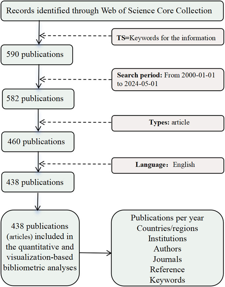
Figure 1. Data retrieval flowchart (image source: drawn by the authors).
2.2 Research methods
Bibliometrics is a scientific field that studies the quantitative characteristics of research literature and its patterns of change (González-Alcaide, 2021). It aims to analyze the quantitative features, statistical distribution, and evolving trends of such literature to explore developments in science, technology, and academic activities and their trajectories (Antons et al., 2020). Bibliometrics primarily employs methods from mathematics, statistics, and computer science to analyze and evaluate literature and its content (Ezugwu et al., 2021). This approach is widely applied not only in academic research and science management but also in intelligence analysis, science policy formulation, academic evaluation, and library management (Cox, 2021). It provides essential tools for understanding the patterns of scientific activities, assessing research outcomes, and optimizing the allocation of research resources (Ramachandran et al., 2021).
This study uses two bibliometric tools, CiteSpace 6.3. R1 software (https://citespace.podia.com/) and VOSviewer 1.6.18 (https://www.vosviewer.com/), in a combination that aims to provide a more comprehensive and detailed understanding of the topic. CiteSpace excels in revealing key documents, field evolution paths, and citation mutations, whereas VOSviewer excels in hot topic identification and knowledge network visualization. Therefore, the two tools provide multilevel complementary perspectives that help explore the overall structure of the research field in depth. However, owing to differences in their analysis algorithms and visualization methods, the use of multiple tools may also lead to contradictory results, which requires researchers to calibrate when interpreting the analysis results to ensure the accuracy and reliability of the conclusions. In addition, the researchers have employed bibliometric methods using Pajek 64 5.16 (https://pajek.software.informer.com/) to analyze the 438 articles retrieved in our search. This analysis encompassed the co-occurrence of countries/regions, institutions, authors, journal publications, and keyword frequencies. In the visualizations produced by these software tools, the circles and text labels represent nodes, with the size of the circles indicating the importance of the nodes (Fang et al., 2023). Different colors denote distinct clusters, while the lines connecting nodes signify co-occurrence relationships, with line thickness indicating the strength of these co-occurrences (Jentner et al., 2023). Additionally, the researchers utilized CiteSpace 6.3. R1 software to conduct a visual cocitation analysis of the literature and to generate relevant maps. In the cocitation analysis graphs, the parameters for CiteSpace were set as follows: the time span covered 2000–2024, with a time slice of 1 year, and a selection criterion of k = 30. Different circles represent different cocited references, with the size of each circle proportional to the citation frequency of the publication. The lines between circles represent cocitation relationships. The size and color of the rings within the circles indicate the number of citations and the corresponding time period during which these citations occurred. These methods enable a comprehensive analysis of the literature on rural settlement spatial patterns, revealing key trends, influential studies, and areas of emerging interest within the field.
3 Results: Knowledge graph visualization
3.1 Analysis of annual publication trends
The study conducted an analysis of publication trends in the field of rural settlement spatial patterns between 2000 and 2024, examining a total of 438 articles. The results, as illustrated in Figure 2, show a significant increase in research output over the past two decades, which can be divided into three main phases: the initial phase, the transition phase, and the rapid growth phase.
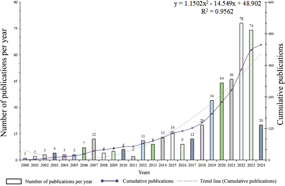
Figure 2. Trend analysis of publication volume (2000–2024) (image source: drawn by the authors).
This study divides the development of rural settlement spatial morphology research into three stages but adjusts the starting point of the growth stage on the basis of the trend in the number of published articles.
Initial stage (2000–2007): During this stage, the number of annual published articles is relatively low, indicating that research had only recently commenced and that growth was relatively slow. The overall publication volume was also low, reflecting a slow growth trend. Research in this phase was still in its early stages, with foundational theories and methodologies being explored and developed, and research resources and funding were relatively limited.
Transition stage (2008–2014): The number of published articles fluctuated during this stage and did not show a significant continuous growth trend. It exhibited intermittent increases in research interest and method exploration. This phase resulted in significant growth in publication numbers, although with considerable year-to-year fluctuations, indicating the periodic intensification of research activities. The rapid development in this phase was driven by advances in research methodologies and technologies, such as GIS and remote sensing, the rise of interdisciplinary research, and increased global attention to rural development issues (Yang E. et al., 2024; Patino and Duque, 2013).
Rapid growth stage (2015 to present): Since 2015, the number of annual publications has increased significantly, with a peak in 2022, reflecting the rapid increase in research attention. This stage reflects the dynamic change in the number of studies and makes the division into three stages more reasonable and continuous.
Regression analysis of the data from 2000 to 2024 resulted in the function model
3.2 Active countries/regions
The analysis of contributions by country reveals the global distribution of research in the field, highlighting the importance of international collaboration in building a platform for scientific cooperation. Such collaboration facilitates the global flow and sharing of knowledge and technology, thereby enhancing overall research quality. According to the data on country contributions, a total of 77 countries published 438 research articles related to rural settlement spatial patterns. The global research investment in this field displays a distinct pattern of both concentration and dispersion. As shown in Table 1, China leads with an overwhelming majority of 243 articles (55.4%), indicating its significant influence and substantial investment in rural settlement spatial pattern research. This prominent difference underscores China’s extensive research resources and academic output in this area. The United States (46 articles) and France (18 articles) followed, representing other key contributors to this field. Countries such as Poland, the United Kingdom, India, and Germany have published between 14 and 17 articles each, reflecting a notable academic presence and influence in the research of rural settlement spatial patterns. However, most other countries, such as the Netherlands, Indonesia, and Belgium, have published fewer than 10 articles. This suggests that while these countries have made relatively small contributions to research on rural settlement spatial patterns, there is widespread global interest in and academic discussion on this topic.
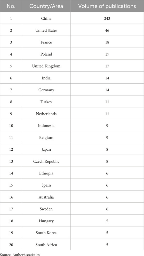
Table 1. Contributions of the top 20 countries.
As depicted in Figure 3, a visualization analysis of publication regions was conducted via VOSviewer software, with a minimum publication threshold set at three articles per country. This resulted in a country collaboration map for research on rural settlement spatial patterns. From Figure 3, it is evident that the United States shows the strongest collaboration tendencies with other countries, with particularly close cooperation with China. Additionally, China has significant collaboration pathways with several European countries, such as France, Germany, and the United Kingdom, indicating an extensive international cooperation network in this field. Similarly, the United States not only collaborates closely with China but also has strong research ties with Canada, Australia, and various European countries, further enhancing its influence within the global research network. European countries, especially France, Germany, and Poland, also exhibit dense collaboration networks with each other. Emerging countries, such as India, Indonesia, and South Africa, despite having relatively few publications, are increasingly forming collaborative networks with major countries, underscoring their rising potential in international research.
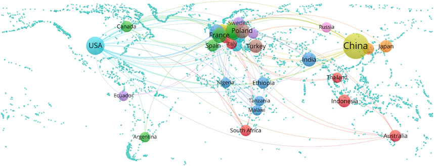
Figure 3. Country cooperation relationship analysis map (image source: drawn by the authors).
Figure 4 illustrates the most significant citation bursts among ten countries worldwide from 2000 to 2024, reflecting a marked increase in academic influence during specific time periods. The United States has the highest burst strength of 7.15, indicating its dominant position in the academic landscape. Traditional research powerhouses, such as England and Sweden, exhibited strong citation bursts in the early 21st century, underscoring their prominence during that time. In contrast, emerging economies, such as Poland and Indonesia, have demonstrated robust academic growth in recent years, highlighting their increasing influence in the global research arena. This phenomenon underscores the diversification of the global research environment and the efforts of various countries to increase their scientific impact through diverse strategies. However, the citation burst analysis in Figure 4 shows a noteworthy phenomenon; that is, although China ranks first in terms of the number of publications, it does not appear in the citation burst list from 2000 to 2024. This may indicate that China’s research output has been relatively concentrated in recent years, and its long-term influence on global research is still growing.
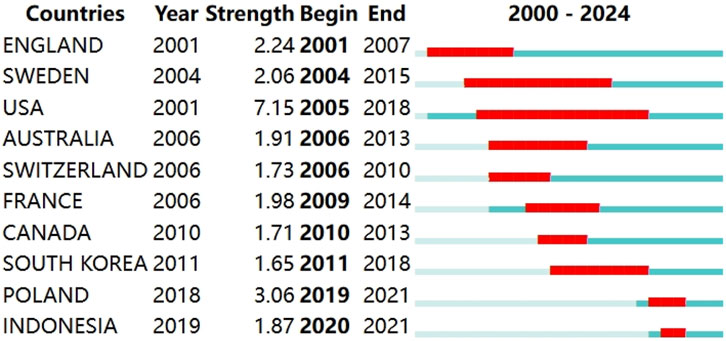
Figure 4. Sudden emergence of the top 10 countries (image source: drawn by the authors).
Therefore, through the comparative analysis of Table 1 and Figures 3, 4, it can be seen that China has a clear advantage in terms of the number of studies, but the global expansion of its academic influence is still developing, whereas the research of the United States shows a strong international citation influence and continuous transnational cooperation. This difference reflects the different academic roles and influence paths of different countries in the study of rural settlement spatial morphology. Overall, the analysis reveals China’s dominant position in the research of rural settlement spatial patterns while also highlighting the academic interest and contributions of other countries. Future research could further explore the collaboration models and research hotspots among these countries to promote the continued development of this field.
3.3 Institutional distribution analysis
According to the data in Table 2, 690 research institutions have published relevant papers in the field of rural settlement spatial morphology in the past 24 years. Among these institutions, the Chinese Academy of Sciences holds the top position with 36 publications, representing 8.22% of the total, indicating its dominant position in this field. Other Chinese institutions, such as the University of the Chinese Academy of Sciences (16 papers) and Beijing Normal University (16 articles), follow closely behind. As shown in Table 2, the top 10 most active institutions contributed approximately 28.3% of the total publications. The top 10 institutions include the Chinese Academy of Sciences (36 articles, 8.22%), University of Chinese Academy of Sciences (16 articles, 3.65%), Beijing Normal University (16 articles, 3.65%), Nanjing University (9 articles, 2.05%), Tsinghua University (9 articles, 2.05%), Sun Yat-sen University (8 articles, 1.83%), Xi’an University of Architecture and Technology (8 articles, 1.83%), Chang’an University (8 articles, 1.83%), Nanjing Normal University (7 articles, 1.6%), and Southwest University (7 articles, 1.6%).
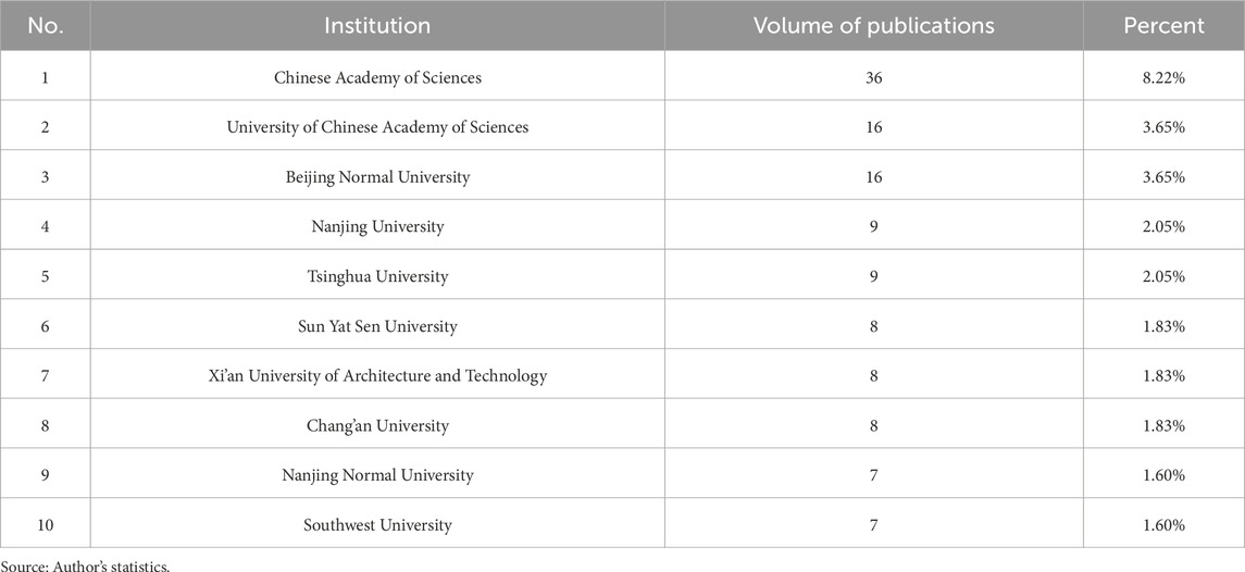
Table 2. Top 10 active institutions by number of publications.
As illustrated in Figure 5, the research institutions involved in the study were analyzed via VOSviewer software. The minimum publication threshold for institutions was set at two articles, resulting in a visualization of the collaboration network among institutions studying the spatial morphology of rural settlements. In this visualization, each circle and text label represents an institution; the lines connecting the circles indicate coauthorship between institutions; the thickness of the lines reflects the strength of collaboration; the gradient color represents the overall strength of collaboration with other institutions; and the size of the circle is positively correlated with the number of publications by the institution. Figure 5’s institutional collaboration network further highlights the close collaboration between major research institutions, particularly the Chinese Academy of Sciences and the University of the Chinese Academy of Sciences. This close collaboration demonstrates the academic influence and collaborative capabilities of major Chinese research institutions in this field. Nanjing Normal University has the highest average number of citations per article, reaching 110, indicating that its research is highly recognized by peers. Renmin University of China, Huaqiao University, and Nanjing Agricultural University have the most recent average publication dates, with a focus on research in this field emerging after 2023, suggesting that these institutions have increasingly prioritized this area of study in recent years. In contrast, foreign research institutions, such as the University of Queensland in Australia, although not ranked highly in Table 2, also exhibit a high degree of collaboration in specific research fields. Overall, Chinese research institutions occupy an important position in the global academic network, but their collaboration with international institutions must be further strengthened.
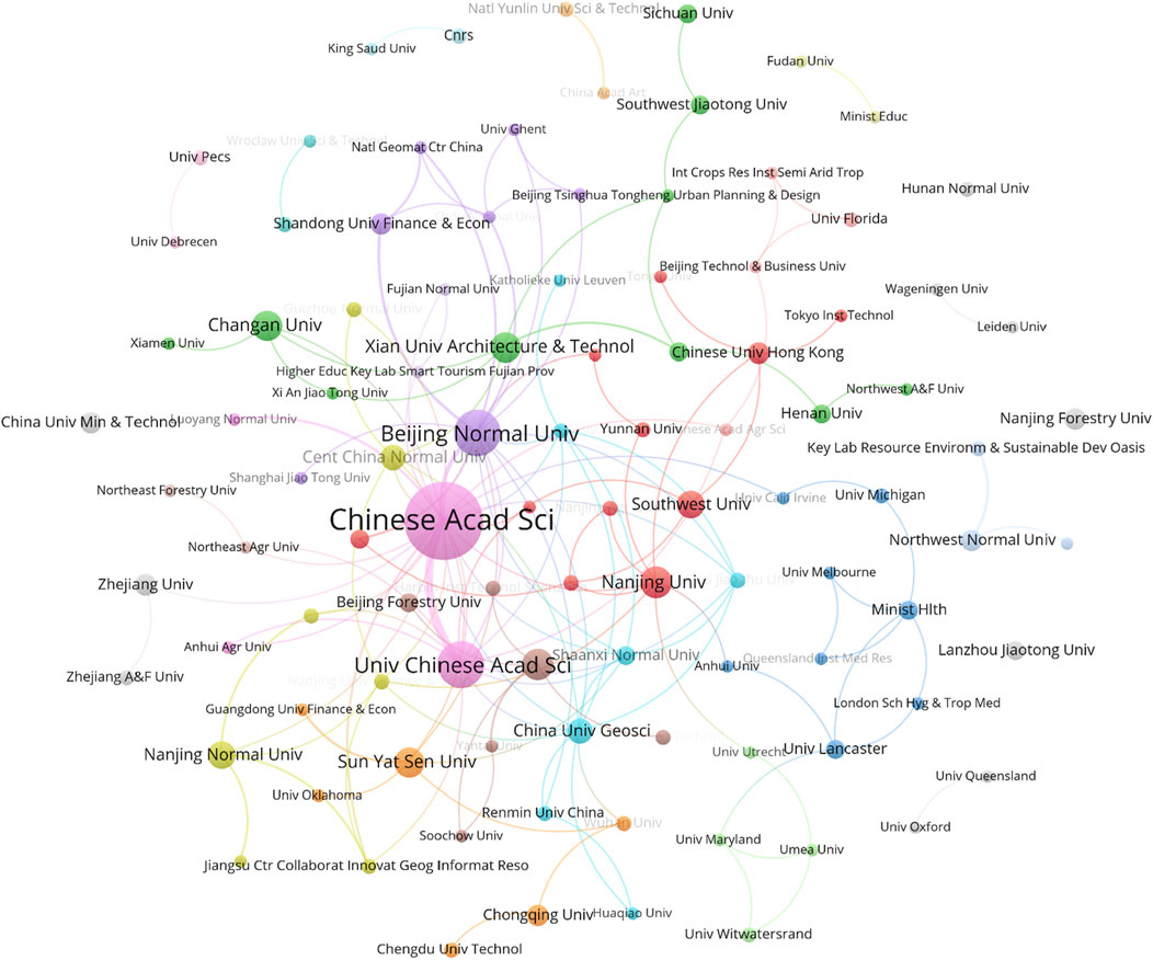
Figure 5. Analysis of institutional partnerships (image source: drawn by the authors).
Figure 6 illustrates the top 10 research institutions worldwide that display the strongest citation bursts in the academic community from 2000 to 2024. Notably, all of these institutions are located in China, highlighting a significant increase in the country’s scientific impact during this period. Nanjing University demonstrated substantial academic growth as early as 2003, whereas the Chinese Academy of Sciences and its affiliated research institutions have consistently maintained a high level of citation bursts since 2020, indicating their extensive influence within the international academic community. This trend suggests that China’s ongoing investment and innovation in the research sector have gradually translated into a notable increase in its global academic influence.
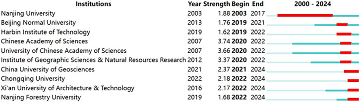
Figure 6. Top ten institutions emergence map (image source: drawn by the authors).
3.4 Analysis of research authors
This study identified the authors who have made significant contributions to the research field of rural settlement spatial morphology. Table 3 lists the main authors who have published more than three articles in the field of rural settlement spatial morphology. The highest ranking is Song Wei, who has published a total of four papers. According to Table 3, Song Wei, Jiang Guanghui, Ma Wenqiu, Zhou Tao, Long Hualou, Hu Yi, Zhang Xiaolin, Chiou Shang-Chia, Liu Tao, Ma Libang, Zhou Jizhe, and Wang Cheng have all made notable contributions to the study of rural settlement spatial morphology.
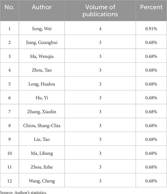
Table 3. Authors with three or more publications.
To reveal the collaborative relationships among these authors, a coauthorship analysis was conducted via VOSviewer software, with the minimum publication threshold set at two articles per author. This analysis produced a coauthorship network map for researchers in the field of rural settlement spatial morphology. In this visualization, each circle and text label form a node representing an author. The coauthorship analysis in Figure 7 reveals the collaborative relationships between authors. As shown in Figure 7, Abd-Elrahman Amr, Grunwald Sabine, Jiang Guanghui, Ma Wenqiu, Smith Scot E., Wani Suhas P., Xu Yiming, and Zhou Tao share the highest collaboration strength. The size of each circle is positively correlated with the number of publications by the author, with Song Wei having the highest number of publications at four. Jiang Guanghui, Ma Wenqiu, Zhou Tao, Long Hualou, Hu Yi, Zhang Xiaolin, Chiou Shang-Chia, Liu Tao, Ma Libang, Zhou Jizhe, and Wang Cheng each have three publications, with the second-highest number of publications. In comparison, other authors, such as Song Wei, Jiang Guanghui, and Zhou Tao, have relatively small coauthorship networks, although they have more individual publications. This shows that there are core research groups in the field, but there room remains for improvement in overall author collaboration, especially in interdisciplinary research and international collaboration.
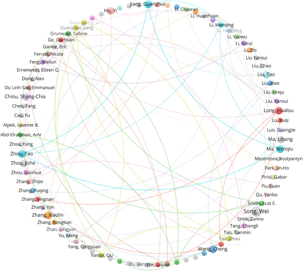
Figure 7. Author co-occurrence analysis plot (image source: drawn by the authors).
Figure 8 presents the top 10 authors worldwide with the strongest citation bursts in the academic community from 2000 to 2024. The data illustrated in the figure highlight the specific years during which these authors’ research received widespread citation, underscoring the significant impact of these researchers in their respective fields. The majority of these citation bursts occurred after 2019, indicating the increasing attention these authors’ research has garnered in recent years. Notably, Song Wei exhibited the highest burst intensity in 2020 (1.95), while other authors, such as Liu Yansui, Chiou Shang-chia, and Strek Zanna, also gained substantial academic influence in a relatively short timeframe. This phenomenon suggests that these researchers may have addressed critical gaps or introduced innovative perspectives in their fields, resulting in a surge of citations and attention. Overall, this trend reflects the rapid advance of global scientific research and the emergence of new academic forces in recent years.
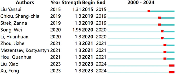
Figure 8. Top 10 author emergence map (image source: drawn by the authors).
3.5 Journal cocitation analysis
Journal cocitation analysis can link journals that do not have an obvious direct relationship. This type of analysis helps assess the specialization of journals and identify core journals while also describing the scientific structure represented by these journals. When two journals have at least one research article cited together in the same reference, they share a cocitation relationship. In this study, VOSviewer software was used to visualize the publications from 219 journals, with a minimum publication threshold of one article and a minimum cocitation frequency of 15. The resulting journal cocitation visualization is shown in Figure 9. The lines represent the strength of the cocitation relationships; the denser the lines are, the closer the relationships are. Figure 9 shows the network of journals with significant cocitation relationships in the field of rural settlement spatial morphology. The journal Land occupies a core position in the cocitation network, with the highest number of cocitations (50 articles). The journal most closely cocited with Land is the Journal of Geographical Sciences. Sustainability and the Journal of Geographical Sciences rank second and third in publication volume, with 32 and 13 articles, respectively. The journal Agriculture, Ecosystems and Environment has the highest average number of citations per article, at 218 citations, indicating a high level of recognition for its research within the academic community. The journal Heritage Science has the most recent average publication date, in 2023, suggesting that this journal has only recently begun to focus on research in this field. These cocitation relationships enable researchers to share resources, data, and methodologies, thereby advancing the overall progress of research on rural settlement spatial morphology.
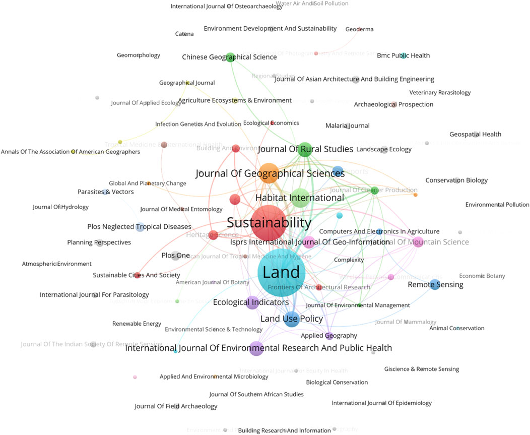
Figure 9. Journal cocitation relationship map (image source: drawn by the authors).
Figure 10 presents the top 10 academic journals with the most pronounced citation bursts from 2000 to 2024. The data reveal that the journals AM J TROP MED HYG (American Journal of Tropical Medicine and Hygiene) and THESIS exhibit the highest citation burst intensities, with values of 10.05 (2005–2017) and 11.67 (2014–2020), respectively. This finding suggests that these two journals had a particularly significant impact on academic research within their respective fields during these periods. Furthermore, the journal LAND-BASEL has experienced a notable citation burst since 2022, with an intensity of 7.19, indicating that it has recently attracted considerable attention within the academic community. The strong performance of these journals reflects their pivotal role in their fields, while the duration and intensity of their citation bursts underscore their importance in advancing academic research and knowledge dissemination.
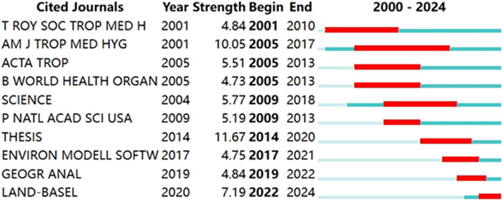
Figure 10. Map of the top ten journal bursts (image source: drawn by the authors).
3.6 Document cocitation analysis
Figure 11 presents a document cocitation analysis map generated via CiteSpace to analyze the cocitation patterns of the literature on the spatial morphology of rural settlements from 1 January 2000, to 1 May 2024. The parameters in CiteSpace were set as follows: time slices from 2000 to 2024, with each slice representing 1 year, and a selection criterion of k=30. In the visualization, purple represents citations from earlier years, whereas yellow represents more recent citations. Overlapping colors indicate that an article was cited across multiple years. The lines connecting the circles indicate cocitation relationships among the documents, with magenta-colored nodes marking key nodes where centrality is greater than 0.1. The size of the circles, or the sum of the sizes of the annual rings, is proportional to the number of cocitations. The figure clearly shows that the most frequently cocited document is Liu YS (2017) (Liu and Li, 2017), with 27 cocitations, followed by Liu YS (2018) (Liu, 2018) and Song W (2020) (Song and Li, 2020), each with 15 cocitations. These results highlight the significant impact of these studies in the field of rural settlement spatial morphology research.
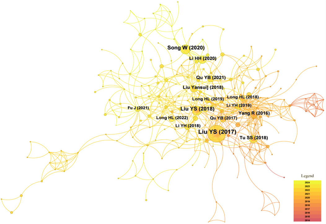
Figure 11. Graph of literature cocitation analysis (image source: drawn by the authors).
3.7 Keyword co-occurrence cluster analysis
To further verify the rationality of each stage, this studies performs comparisons and triangulation analyses with the help of Figures 12–14. Keywords are not simply extractions from a text but also reflect the core ideas and content of an article, representing the authors’ concise summary of their research focus. By constructing a keyword co-occurrence knowledge map and analyzing the distribution of their frequency and temporal evolution, the development trends of research frontiers and hot topics in different periods can be visually demonstrated. The keyword cluster diagram in Figure 12 shows the distribution and associations of different research hotspots, reflecting the main themes in rural settlement research. As shown in Figure 12, this study conducted keyword co-occurrence cluster analysis via VOSviewer software. The minimum occurrence frequency of keywords was set to two, filtering out 104 keywords from a total of 1,562, resulting in a clear and detailed visualization map. In this map, each node is represented by a circle and a label, with the size of the circle proportional to the frequency of keyword occurrence, whereby the thickness of the connecting lines indicates the strength of the relationship between keywords. The different colored nodes represent different research focuses, forming four distinct clusters. This visualization effectively highlights the key areas of focus in the field and provides insight into the evolving trends and emerging hotspots within academic research on rural settlement spatial morphology.
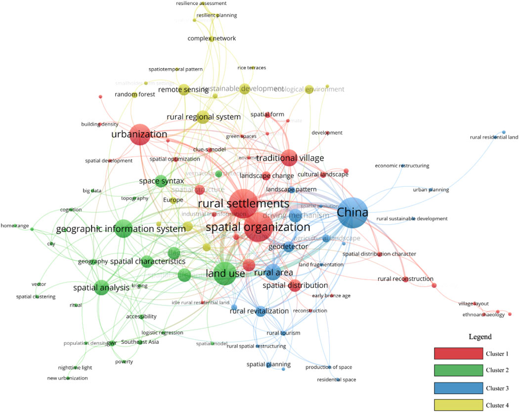
Figure 12. Hotspot keyword frequency cluster analysis map (image source: drawn by the authors).
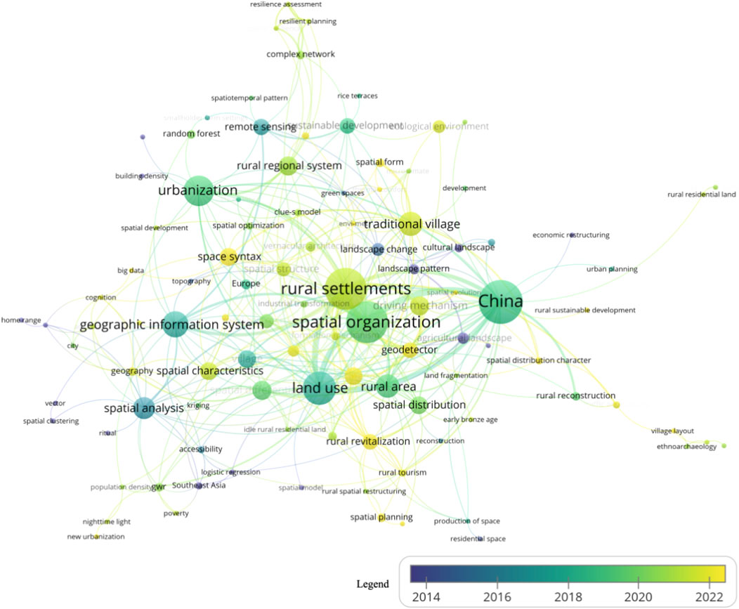
Figure 13. Hotspot keywords frequency time variation chart (image source: drawn by the authors).
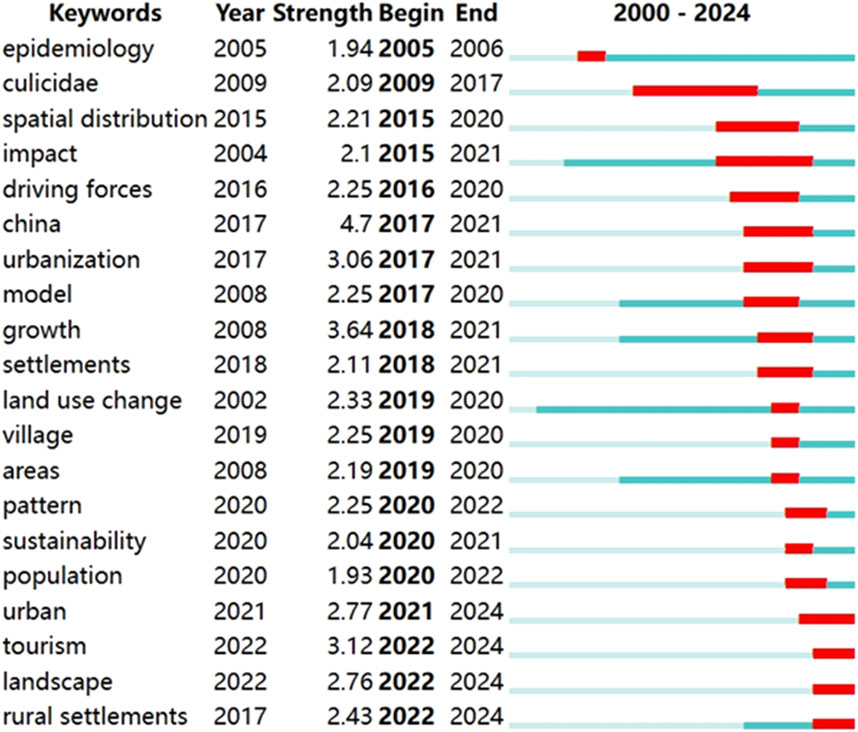
Figure 14. Map of the top 20 most cited keyword bursts (image source: drawn by the authors).
Red Cluster 1 focuses on “Rural Settlements and Spatial Organization”, with central keywords including “rural settlements” (Mao et al., 2017; Popović, 2020), “spatial organization” (Jia et al., 2020; Zhou and Hou, 2021), “urbanization” (Zhu et al., 2020), and “traditional villages” (Bian et al., 2022). This cluster primarily investigates the structure and spatial organization of rural settlements, exploring how these structures maintain their traditional characteristics while gradually integrating modern elements in the process of modernization (Chen X. et al., 2020).
Green Cluster 2 revolves around “Land Use and Spatial Analysis Techniques,” with core keywords such as “land use,” “Geographic Information Systems (GIS)” (Kurowska et al., 2020), “spatial analysis” (Ma et al., 2022), and “spatial features” (Kong X. et al., 2021). This cluster emphasizes the application of GIS and other technological tools to study land use patterns and spatial distribution characteristics in rural areas. It also emphasizes the use of spatial analysis techniques, such as spatial autocorrelation and spatial regression, to explore the features of land use and their changing trends (Liu et al., 2022b; Li et al., 2020; You et al., 2020).
Blue Cluster 3 is dedicated to “China’s Rural Areas and Their Driving Mechanisms,” focusing on keywords such as “China” (Li et al., 2021), “rural areas” (Lu et al., 2020), “driving mechanisms” (Tan et al., 2021), and “spatial distribution” (Guo et al., 2020). The research in this cluster delves into the spatial distribution of rural areas in China and the driving mechanisms behind it. This includes examining the impacts of natural, economic, and social factors, along with conducting in-depth analysis of regional disparities and policy effects (Ma and Tong, 2022).
Yellow Cluster 4 explores “Rural Regional Systems and Sustainable Development,” focusing on core keywords such as “rural regional systems” (Ma et al., 2020), “sustainable development” (Horlings and Padt, 2013), and “complex networks” (Castells, 2020). This cluster highlights a multidisciplinary approach to examining the ecological, social, and economic aspects of rural regions (Ricket et al., 2023). It delves into strategies for achieving sustainable development in rural areas and the use of complex network theory to analyze the interactions and self-organizing traits of different elements within rural systems (Li et al., 2023; Meng et al., 2024).
The keyword time change graph in Figure 13 shows the frequency of these topics in different periods, which can help identify the research focus of each stage. Each node in the graph consists of a circle and a label, with the circle’s size proportional to the frequency of keyword occurrence. The color of each circle, as indicated by the gradient in the lower right corner, represents the average year of occurrence. The blue color indicates that the keyword appeared earlier, whereas yellow indicates a more recent appearance. For example, in the early stage, keywords such as “spatial clustering” are concentrated mainly in the blue area, whereas in the later stage, keywords such as “rural revitalization” and “carbon emissions” are concentrated in the newer, yellow area.
Research on the spatial morphology of rural settlements over the past 24 years can be divided into five stages. The five-stage model of rural settlement literature evolution proposed in this study is based on a comprehensive analysis of keyword co-occurrence frequencies and hotspot temporal changes. Although the time intervals of each stage are not the same, this division reflects the characteristics and change rates of research in different development periods. The first stage (2005–2010) lasted for 6 years and focused on basic spatial clustering and vector analysis techniques. This was the initial stage of rural settlement research, and research progress was relatively slow. In contrast, the third stage (2016–2018) lasted only 3 years, but it marked the large-scale application of GIS and remote sensing technology, which enabled the research to develop rapidly. Thus, this stage was more compact.
Early Stage (2005–2010): The hotspot keywords were “spatial clustering” and “vector (Getis et al., 2010).” Research during this period focused on fundamental spatial analysis techniques to comprehend and elucidate the spatial distribution and patterns of rural settlements (Carvalho et al., 2009). These foundational techniques established the basis for advanced spatial analysis methods in subsequent years (Yu and Ng, 2007).
Second Stage (2011–2015): The hotspot keywords of this stage were “agricultural landscape” and “cultural landscape.” The research focus during this phase transitioned toward examining land use and landscape changes in rural regions, specifically agricultural landscapes (Kanianska et al., 2014). This change signifies an increasing interest in agricultural practices and rural land use trends (Palacios et al., 2013). The exploration of cultural landscapes highlights the burgeoning academic curiosity regarding the interplay between human activities and the natural environment in rural areas, encompassing the conservation and utilization of historical heritage and traditional landscapes (Schofield and Szymanski, 2011; Ólafsdóttir and Dowling, 2014).
Third Stage (2016–2018): The hotspot keywords during this period were “remote sensing,” “Geographic Information Systems (GIS),” and “land use.” The extensive utilization of remote sensing and GIS technologies significantly propelled research on rural spatial morphology (Vinodkumar, 2016). These technologies offered more accurate data and robust analytical capabilities, facilitating large-scale and high-precision spatial analyses (Degbelo et al., 2016). The emphasis on “land use” as a keyword indicates an increasing focus on optimizing and overseeing land resources in rural regions, mirroring the escalating need for sustainable development and resource management (Dandekar, 2016).
Fourth Stage (2019–2021): The hotspot keywords were “spatial differentiation (Yang R. et al., 2020), “urbanization (Chen et al., 2021),” and “rural reconstruction (Long et al., 2019).” With the acceleration of urbanization, researchers shifted their attention to urbanization’s effects on rural regions (Xu and Zhang, 2021). The term “rural reconstruction” signifies the importance of preserving the distinctiveness and vibrancy of rural areas by implementing reconstruction and planning strategies to address urbanization challenges, which emerged as a primary research focus (Azmi et al., 2021). The exploration of spatial differentiation underscores scholars’ curiosity regarding the variations among different spatial units within rural areas and the factors that influence these distinctions, which are essential for developing accurate policies (Yang et al., 2021).
Fifth Stage (2022 onward): The hotspot keywords are “rural revitalization (Gong et al., 2022), “spatial planning (Dong J. et al., 2022),” and “carbon emissions (Yin R. et al., 2022),” reflecting the latest research trends. The emphasis on “rural revitalization” as a keyword indicates a policy-driven focus on enhancing the economic, social, and environmental development of rural areas. Researchers are exploring how comprehensive policy measures can promote holistic development in rural regions (Bi and Yang, 2023). The focus on “spatial planning” highlights the growing importance of rational layout and scientific planning in rural spaces (Zeng et al., 2023). The emergence of emissions as a hotspot reflects the increasing demand for carbon reduction and green development in rural areas, especially in the context of global climate change (Ang-Zu et al., 2024; Jiang and Shi, 2023; Wu et al., 2024).
Figure 14 also describes the keywords that have emerged from rural settlement research. It presents the 20 keywords with the strongest citation bursts in academic research from 2000 to 2024. These keywords, such as “China” and “urbanization,” represent hot spots of academic attention during a specific period of time. This analysis not only provides the dynamic change trajectory of research topics at each stage but also reflects the migration path of research frontiers and hot spots in the field of rural settlements. The figure indicates that “China” and “urbanization” are the keywords with the highest burst strengths, recorded at 4.7 (2017–2021) and 3.06 (2017–2021), respectively. This suggests that research pertaining to China and urbanization received considerable attention during these years. Furthermore, keywords such as “growth,” “tourism,” and “rural settlements” have also exhibited strong citation bursts in more recent years, reflecting significant academic interest and research activity in these domains (Zhang R. et al., 2022; Qian et al., 2013). This trend implies that global academic research hotspots are gradually transitioning from traditional topics to contemporary issues related to social development, urbanization, and environmental and resource management (Zhang et al., 2020). The emergence of these keywords not only underscores current research frontiers and hotspots but also helps researchers identify potential future research directions that are likely to continue attracting substantial attention.
Overall, the logic behind the five-stage model of the evolution of rural settlement literature can be more clearly understood through the triangular analysis of Figures 12–14. These figures show the aggregation and transfer of research topics in the field, verifying the rationality and unique characteristics of different stages, thus providing strong support for the validity of the research hotspots and future development directions.
4 Discussion: spotlight on topics, future trends and challenges
4.1 Research topics, hot topics and their evolution paths
This study, which analyzes the contributions of countries, institutions, and collaborators, reveals that Chinese research institutions and authors exhibit the highest level of activity in the field of rural settlement spatial morphology, establishing themselves as leading contributors owing to their substantial output. Institutions such as the Chinese Academy of Sciences and other prominent universities have been at the forefront of this research for years, a phenomenon driven by several factors: (1) the strong emphasis of the Chinese political system on rural revitalization, (2) the large rural population and extensive rural land area in China, and (3) the availability of abundant research studies on the spatial morphology of rural settlements. Furthermore, the emergence of new research institutions in developing countries, such as India, Indonesia, and South Africa, underscores the growing global interest in and participation in the study of rural settlement spatial morphology. Therefore, this study advocates for the promotion of international cooperation and research exchanges in this field, particularly enhancing collaboration between institutions in different countries and those in China. Collaborative projects and academic exchanges will facilitate the advancement of interdisciplinary approaches.
Analysis of the author collaboration network indicates that although certain authors have established robust collaborative networks, the overall level of cooperation requires improvement. While close collaboration exists within specific disciplines, the lack of interdisciplinary cooperation restricts the capacity to address complex, multifaceted issues. Therefore, there is an urgent need to enhance academic collaboration across disciplines and regions to bolster innovative research in the field of rural settlement spatial morphology.
Keyword co-occurrence and clustering analyses indicate that topics such as the spatial organization of rural areas, spatiotemporal evolution, pattern distribution, driving mechanisms, and sustainable development of regional systems have emerged as significant research hotspots in the study of rural settlement spatial morphology (Shang et al., 2024). This trend reflects a heightened concern among researchers regarding the challenges posed by urbanization, particularly in the context of updating, preserving, and planning the governance of rural settlement spatial morphology, with an emphasis on enhancing the sustainability of these spatial forms (Guevara, 2014; Zhu and Ling, 2022).
During the urbanization process, the spatial morphology of rural settlements faces the dual challenge of preserving traditional endogenous structures while integrating external spatial organizations (Sun et al., 2021). At the macro level, research emphasizes rural regional systems and sustainable development, employing complex network and meme theories to investigate settlement clusters within these systems (Huet, 2013; Liu et al., 2024). This research analyzes the causal relationships among regional economic, cultural, and political development within the context of national land planning, aiming to establish scientifically organized rural regional systems that promote mutual development and enhance the self-organizing characteristics of regional industries and economic carriers (Zhang et al., 2021; Zhang Q. et al., 2022). At the micro level, the focus shifts to the spatiotemporal distribution, spatial differentiation, and driving mechanisms of settlements, examining the changes in rural settlement spatial morphology (Zhang X. et al., 2024; Liu et al., 2022c). By utilizing land use patch data, geographic information, spatial syntax, and morphological index data, researchers have assessed the evolution of rural settlement spatial morphology and its impacts over historical periods (Wang and Yuan, 2019; Zhang et al., 2023). Both macro- and microlevel studies have investigated the dynamic development and transformations in rural settlement spatial morphology across varying scales.
The analysis of research methodologies reveals a notable shift from qualitative to quantitative research in the field of rural settlement spatial morphology, accompanied by a trend toward diversification and interdisciplinary approaches (Drobnjaković and Steinfürer, 2024). The research perspective is broadening, moving beyond the examination of specific spatial forms to encompass macrolevel planning and governance discussions. Early studies relied primarily on qualitative analyses based on morphological characteristics for classifying settlements, with a limited focus on the spatiotemporal evolution of rural settlement spatial morphology (Tiwari, 1981). Since 2012, there has been increasing emphasis within the scientific community on the spatial morphology of rural settlements. The integration of spatial quantitative research methods such as GIS, geographic detectors, and spatial syntax, along with the availability of diverse data sources, has enhanced data acquisition and analysis techniques (Bluemke et al., 2017). This has led to significant advances in understanding the spatiotemporal evolution, pattern distribution, driving factors, optimal layout strategies, and land morphology simulation and prediction of rural settlements (Chen and Wang, 2021). However, tools such as GIS, spatial syntax, and geographic detectors have inherent limitations; they can quantify changes in spatial content but do not fully account for or engage with variables related to social, cultural, and economic factors (Chan et al., 2012). Consequently, there is a pressing need to enhance the comprehensiveness and standardization of data samples, diversify spatial analysis algorithms, improve model precision, and develop comprehensive statistical modes and methods that incorporate multisource factors.
4.2 Future research directions
The temporal changes in hotspot keywords indicate that research on the spatial morphology of rural settlements in response to the new urbanization process and its social context is emerging as a significant trend for future studies. This study advocates for a focus on sustainable rural development through the utilization of urban‒rural big data platforms, incorporating keywords such as carbon emissions, new urbanization, and social network analysis (De Jong et al., 2015; Zhang L. et al., 2024). By integrating Geographic Information Systems (GISs) with digital technology and artificial intelligence, researchers can investigate the spatiotemporal evolution mechanisms and trend predictions of rural settlement spatial morphology via big data platforms (Li and Hsu, 2022).
In the course of research, it is essential to propose novel concepts for the study of the spatial morphology of rural settlements (Marcus and Colding, 2014). This entails employing scientifically quantifiable methods to analyze the processes of spatial evolution within these settlements, summarizing various evolution patterns and their driving mechanisms, and establishing representative studies of regional settlement systems (Kong L. et al., 2021).
The analysis of research trends indicates that current studies primarily emphasize technical and geographical information boundaries, including spatial distribution, spatial organization, and formation mechanisms. However, in addition to physical spatial morphology, it is essential to consider the influences of political systems, economic conditions, and regional cultures on the spatial morphology of rural settlements (Bański and Wesołowska, 2010; Tian et al., 2012; Long et al., 2020). A significant issue that warrants exploration is how to comprehensively integrate multiple factors and utilize scientifically quantifiable analytical methods for statistical analysis, clustering, and deconstruction to achieve sustainable rural spatial planning and development (Madanipour and Hull, 2017; Zhang Z. et al., 2024).
Future research should prioritize the comprehensive consideration of various factors and leverage advanced technologies, such as big data and artificial intelligence, to facilitate dynamic analysis and prediction of rural settlement spatial morphology (Sowmiya Narayanan and Manimaran, 2024). By fostering interdisciplinary collaboration that integrates political, economic, and cultural dimensions, systematic strategies for sustainable rural development can be proposed, ultimately aiming to achieve the goals of coordinated urban–rural development and rural revitalization (Yin X. et al., 2022; Qu et al., 2022).
4.3 Challenges and issues
In emphasizing the preservation and exploration of the mechanisms underlying the spatial morphology of rural settlements, it is essential to consider the ecological vulnerability of agricultural settlements and the active involvement of village residents (Sun et al., 2022; Yin et al., 2024). Research and practice in rural settlement spatial morphology should prioritize the essence of place and the inheritance of the landscape genes that shape its morphology (Sa et al., 2024). This approach ensures that initiatives aimed at developing rural settlement spatial morphology do not exacerbate inequalities in rural life or compromise the unique characteristics and fragility of rural landscapes (Taruza, 2023; Jia et al., 2024).
The application of open urban‒rural data platforms, artificial intelligence, convolutional neural networks, and emerging geographic information technologies provides new tools for studying the spatial morphology of rural settlements (Zhang J. et al., 2022; Yu and Fang, 2023). However, these innovations also present potential risks and challenges. For example, concerns regarding data privacy, ethics, and the dangers of excessive dependence on technology must be thoroughly evaluated (Ismagilova et al., 2022). It is essential to employ these technologies judiciously and within a regulated framework to ensure that they contribute effectively to the sustainable development of the spatial morphology of rural settlements and enhance the wellbeing of village communities.
Research and practice in the field of rural settlement spatial morphology must extend beyond geographic information technology and spatial governance to encompass social, economic, environmental, and ethical dimensions. Addressing these multiple dimensions is essential for achieving truly sustainable and environmentally friendly development of the spatial morphology of rural settlements.
5 Conclusion
5.1 Research discovery
This study utilized CiteSpace 6.2 R4 and VOS Viewer 1.6 software to conduct a comprehensive systematic review of the literature on rural settlement spatial morphology from 2000 to 2024 on the basis of the Web of Science core database. The analysis encompassed various dimensions, such as annual publication trends, active countries and regions, institutional distributions, author contributions, journal cocitations, and keyword co-occurrences, to explore trends, hotspots, and future prospects for research on the spatial morphology of rural settlements.
The results indicate that research in this field spans multiple disciplines, primarily focusing on architecture, urban and rural planning, geography, and sociology. At the national level, China, the United States, and France lead in research output and influence in the field. Institutionally, the Chinese Academy of Sciences, University of Chinese Academy of Sciences, and Beijing Normal University have made significant research contributions and collaborations. At the author level, scholars such as Song Wei, Jiang Guanghui, and Ma Wenqiu have produced highly cited and impactful research. In terms of journals, Land, Sustainability, and the Journal of Geographical Sciences are identified as core journals in this field, publishing numerous high-quality and influential papers.
Furthermore, the study highlights four major research hotspots in rural settlement spatial morphology: rural residential areas, spatial organization, land use, driving mechanisms, and rural sustainable development. These hotspots are closely interrelated and mutually influential, reflecting the knowledge structure and thematic evolution of the field. Spatial syntax and GIS (geographic information systems) have emerged as the most precise and efficient research methods and are often used for land use and spatial analysis. The research predominantly focuses on rural areas in China, particularly rural residential areas and traditional villages, with an emphasis on the driving forces and challenges of rural development in these regions. Additionally, sustainable rural development, rural transformation, and structural adjustment are identified as key challenges facing the field, particularly in the context of the new era’s transformation of rural regional systems.
The development of rural settlement spatial morphology research can be divided into five stages: the initial stage (2005–2010), the stable development stage (2011–2015), the mature development stage (2016–2018), the research differentiation stage (2019–2021), and the theoretical and practical stage (2022–2024). The keywords associated with each stage distinctly reflect the research focus and dynamics of that period.
5.2 Study limitations
This study is not without its limitations, and future research should aim to address the following issues. (1) Limitations in sample data selection: This study focused on core journals in the field of rural settlement spatial morphology. However, given that China has the highest publication output in this field and a diverse array of journals, certain relevant studies may have been excluded from this analysis, potentially leading to gaps in the findings. Future research could incorporate journals from the China National Knowledge Infrastructure (CNKI) core database to facilitate a more comprehensive analysis or comparative study. (2) Fragmentation in the temporal scope of data: The development of rural settlement living environments spans several centuries, with rural settlement spatial morphology serving as a significant material expression of these environments. In light of this extensive history, future research could broaden the temporal scope of the study to better understand how various linguistic definitions of rural settlements have evolved across different countries. This would involve a deeper exploration of the subject and an extension of the timeline to present a more complete theoretical development trajectory of research in rural settlement spatial morphology.
In summary, this study offers a comprehensive and in-depth overview of the academic achievements and developmental trends in the field of rural settlement spatial morphology from a bibliometric perspective. These findings are crucial for fostering academic exchange, collaboration, and innovation while also providing valuable references and insights for future in-depth research in this field.
Author contributions
YH: Conceptualization, Data curation, Formal Analysis, Funding acquisition, Investigation, Methodology, Project administration, Resources, Software, Supervision, Validation, Visualization, Writing–original draft, Writing–review and editing. JX: Data curation, Methodology, Writing–original draft, Formal Analysis, Software. YC: Formal Analysis, Validation, Visualization, Writing–original draft, Supervision, Writing–review and editing. JH: Funding acquisition, Writing–review and editing, Project administration, Validation.
Funding
The author(s) declare that financial support was received for the research, authorship, and/or publication of this article. The following funding sources support this research: (1) the General Research Project of the Zhejiang Provincial Department of Education: “The Impact of Local Identity on Rural Settlements in the Middle Reaches of the Nanxi River and Optimization Strategies” (grant number: Y202353008); (2) the 2024 Zhejiang Provincial Philosophy and Social Science Planning “Provincial-City Cooperation” Project: “The Distribution Characteristics, Spatiotemporal Evolution, and Influencing Factors of Rural Settlements in the Nanxi River Basin from 1990 to 2020” (grant number: 24SSHZ085YB).
Conflict of interest
The authors declare that the research was conducted in the absence of any commercial or financial relationships that could be construed as a potential conflictconflicts of interest.
Generative AI statement
The author(s) declare that no Generative AI was used in the creation of this manuscript.
Publisher’s note
All claims expressed in this article are solely those of the authors and do not necessarily represent those of their affiliated organizations, or those of the publisher, the editors and the reviewers. Any product that may be evaluated in this article, or claim that may be made by its manufacturer, is not guaranteed or endorsed by the publisher.
References
An, Y., Wu, X., Liu, R., Liu, L., and Liu, P. (2023). Quantitative analysis village spatial morphology using “SPSS+ GIS” approach: a case study of linxia hui autonomous prefecture. Sustainability 15 (24), 16828. doi:10.3390/su152416828
Ang-Zu, C., Guo, R., Yu-Hao, Z., and Wu, J. (2024). Status and trends of carbon emissions research at the county level in China. Adv. Clim. Change Res. doi:10.1016/j.accre.2024.03.003
Antons, D., Grünwald, E., Cichy, P., and Salge, T. O. (2020). The application of text mining methods in innovation research: current state, evolution patterns, and development priorities. R&D Manag. 50 (3), 329–351. doi:10.1111/radm.12408
Arts, B., Buizer, M., Horlings, L., Ingram, V., Van Oosten, C., and Opdam, P. (2017). Landscape approaches: a state-of-the-art review. Annu. Rev. Environ. Resour. 42 (1), 439–463. doi:10.1146/annurev-environ-102016-060932
Azmi, N. F., Ali, A. S., and Ahmad, F. (2021). Exploring the challenges in protecting the identity of small historic towns in Malaysia. Open House Int. 46 (1), 64–80. doi:10.1108/OHI-05-2020-0028
Bański, J., and Wesołowska, M. (2010). Transformations in housing construction in rural areas of Poland's Lublin region—influence on the spatial settlement structure and landscape aesthetics. Landsc. urban Plan. 94 (2), 116–126. doi:10.1016/j.landurbplan.2009.08.005
Bi, G., and Yang, Q. (2023). The spatial production of rural settlements as rural homestays in the context of rural revitalization: evidence from a rural tourism experiment in a Chinese village. Land use policy 128, 106600. doi:10.1016/j.landusepol.2023.106600
Bian, J., Chen, W., and Zeng, J. (2022). Spatial distribution characteristics and influencing factors of traditional villages in China. Int. J. Environ. Res. Public Health 19 (8), 4627. doi:10.3390/ijerph19084627
Bluemke, M., Resch, B., Lechner, C., Westerholt, R., and Kolb, J.-P. (2017). In Integrating geographic information into survey research: current applications, challenges and future avenues. Surv. Res. Methods, 307–327. doi:10.18148/srm/2017.v11i3.6733
Carvalho, A. X. Y., Albuquerque, P. H. M., de Almeida Junior, G. R., and Guimaraes, R. D. (2009). Spatial hierarchical clustering. Rev. Bras. Biom. 27 (3), 411–442.
Castells, M. (2020). “Space of flows, space of places: materials for a theory of urbanism in the information age,” in The city reader (London, United Kingdom: Routledge), 240–251.
Chan, K. M., Guerry, A. D., Balvanera, P., Klain, S., Satterfield, T., Basurto, X., et al. (2012). Where are cultural and social in ecosystem services? A framework for constructive engagement. BioScience 62 (8), 744–756. doi:10.1525/bio.2012.62.8.7
Chen, K., Long, H., Liao, L., Tu, S., and Li, T. (2020a). Land use transitions and urban-rural integrated development: theoretical framework and China’s evidence. Land use policy 92, 104465. doi:10.1016/j.landusepol.2020.104465
Chen, L., and Wang, Q. (2021). Spatio-temporal evolution and influencing factors of land use in Tibetan region: 1995–2025. Earth Sci. Inf. 14 (4), 1821–1832. doi:10.1007/s12145-021-00627-0
Chen, M., Zhou, Y., Huang, X., and Ye, C. (2021). The integration of new-type urbanization and rural revitalization strategies in China: origin, reality and future trends. Land 10 (2), 207. doi:10.3390/land10020207
Chen, X., Xie, W., and Li, H. (2020b). The spatial evolution process, characteristics and driving factors of traditional villages from the perspective of the cultural ecosystem: a case study of Chengkan Village. Habitat Int. 104, 102250. doi:10.1016/j.habitatint.2020.102250
Clark, J. K., McChesney, R., Munroe, D. K., and Irwin, E. G. (2009). Spatial characteristics of exurban settlement pattern in the United States. Landsc. urban Plan. 90 (3-4), 178–188. doi:10.1016/j.landurbplan.2008.11.002
Coenen, L., Benneworth, P., and Truffer, B. (2012). Toward a spatial perspective on sustainability transitions. Res. policy 41 (6), 968–979. doi:10.1016/j.respol.2012.02.014
Cox, J. (2021). The higher education environment driving academic library strategy: a political, economic, social and technological (PEST) analysis. J. Acad. Librariansh. 47 (1), 102219. doi:10.1016/j.acalib.2020.102219
Dandekar, H. C. (2016). Shifts in rural planning in the US and India. Int. Plan. Stud. 21 (3), 230–244. doi:10.1080/13563475.2016.1185006
Degbelo, A., Granell, C., Trilles, S., Bhattacharya, D., Casteleyn, S., and Kray, C. (2016). Opening up smart cities: citizen-centric challenges and opportunities from GIScience. ISPRS Int. J. Geo-Information 5 (2), 16. doi:10.3390/ijgi5020016
De Jong, M., Joss, S., Schraven, D., Zhan, C., and Weijnen, M. (2015). Sustainable–smart–resilient–low carbon–eco–knowledge cities; making sense of a multitude of concepts promoting sustainable urbanization. J. Clean. Prod. 109, 25–38. doi:10.1016/j.jclepro.2015.02.004
Di Fazio, S., and Modica, G. (2018). Historic rural landscapes: sustainable planning strategies and action criteria. The Italian experience in the global and European context. Sustainability 10 (11), 3834. doi:10.3390/su10113834
Dong, J., Jiang, H., Gu, T., Liu, Y., and Peng, J. (2022b). Sustainable landscape pattern: a landscape approach to serving spatial planning. Landsc. Ecol. 37, 31–42. doi:10.1007/s10980-021-01329-0
Dong, Y., Cheng, P., and Kong, X. (2022a). Spatially explicit restructuring of rural settlements: a dual-scale coupling approach. J. Rural Stud. 94, 239–249. doi:10.1016/j.jrurstud.2022.06.011
Drobnjaković, M., and Steinfürer, A. (2024). Re-thinking rurality: towards a new research approach and rural-urban spatial gradient establishment in Serbia. Appl. Geogr. 163, 103195. doi:10.1016/j.apgeog.2023.103195
Ekici, S. C., Özçakır, Ö., and Bilgin Altinöz, A. G. (2024). Sustainability of historic rural settlements based on participatory conservation approach: kemer village in Turkey. J. Cult. Herit. Manag. Sustain. Dev. 14 (4), 497–520. doi:10.1108/JCHMSD-05-2021-0087
Esch, T., Marconcini, M., Marmanis, D., Zeidler, J., Elsayed, S., Metz, A., et al. (2014). Dimensioning urbanization–An advanced procedure for characterizing human settlement properties and patterns using spatial network analysis. Appl. Geogr. 55, 212–228. doi:10.1016/j.apgeog.2014.09.009
Ezugwu, A. E., Shukla, A. K., Agbaje, M. B., Oyelade, O. N., José-García, A., and Agushaka, J. O. (2021). Automatic clustering algorithms: a systematic review and bibliometric analysis of relevant literature. Neural Comput. Appl. 33, 6247–6306. doi:10.1007/s00521-020-05395-4
Fang, Q., Inoue, T., Li, D., Liu, Q., and Ma, J. (2023). Transit-oriented development and sustainable cities: a visual analysis of the literature based on CiteSpace and VOSviewer. Sustainability 15 (10), 8223. doi:10.3390/su15108223
Gauthier, P., and Gilliland, J. (2006). Mapping urban morphology: a classification scheme for interpreting contributions to the study of urban form. Urban Morphol. 10 (1), 41–50. doi:10.51347/jum.v10i1.3926
Getis, A., Morrison, A. C., Gray, K., and Scott, T. W. (2010). Characteristics of the spatial pattern of the dengue vector, Aedes aegypti, in Iquitos, Peru. Perspect. Spatial Data Analysis, 203–225. doi:10.1007/978-3-642-01976-0_15
Gobattoni, F., Pelorosso, R., Leone, A., and Ripa, M. N. (2015). Sustainable rural development: the role of traditional activities in Central Italy. Land use policy 48, 412–427. doi:10.1016/j.landusepol.2015.06.013
Gong, J., Jian, Y., Chen, W., Liu, Y., and Hu, Y. (2022). Transitions in rural settlements and implications for rural revitalization in Guangdong Province. J. Rural Stud. 93, 359–366. doi:10.1016/j.jrurstud.2019.10.037
González-Alcaide, G. (2021). Bibliometric studies outside the information science and library science field: uncontainable or uncontrollable? Scientometrics 126 (8), 6837–6870. doi:10.1007/s11192-021-04061-3
Gruber, S. (2017). “Convention concerning the protection of the world cultural and natural heritage 1972,” in Elgar encyclopedia of environmental law (Cheltenham, UK: Edward Elgar Publishing Limited), 60–66.
Guevara, N. K. A. (2014). Informality and formalization of informal settlements at the turn of the third millennium: practices and challenges in urban planning. J. Stud. Soc. Sci. 9 (2).
Guo, P., Zhang, F., Wang, H., and Qin, F. (2020). Suitability evaluation and layout optimization of the spatial distribution of rural residential areas. Sustainability 12 (6), 2409. doi:10.3390/su12062409
Holm, P., Goodsite, M. E., Cloetingh, S., Agnoletti, M., Moldan, B., Lang, D. J., et al. (2013). Collaboration between the natural, social and human sciences in global change research. Environ. Sci. and policy 28, 25–35. doi:10.1016/j.envsci.2012.11.010
Horlings, I., and Padt, F. (2013). Leadership for sustainable regional development in rural areas: bridging personal and institutional aspects. Sustain. Dev. 21 (6), 413–424. doi:10.1002/sd.526
Hua, H., Sun, J., and Yang, Z. (2024). Rural self-organizing resilience: village collective strategies and negotiation paths in urbanization process in the tpsnt framework: a case study of the hongren village, China. Sustainability 16 (12), 5202. doi:10.3390/su16125202
Huet, S. (2013). Individual based models of social systems: data driven hybrid micro-models of rural development and collective dynamics of filtering or rejecting messages. Other [cs.OH]. Univ. Blaise Pascal - Clermont-Ferrand II: Clermont Ferrand, France. Available at: https://theses.hal.science/tel-00856248/ (Accessed November 20, 2024).
Ismagilova, E., Hughes, L., Rana, N. P., and Dwivedi, Y. K. (2022). Security, privacy and risks within smart cities: literature review and development of a smart city interaction framework. Inf. Syst. Front. 24, 393–414. doi:10.1007/s10796-020-10044-1
Jarvenpa, R., and Brumbach, H. J. (1988). Socio-spatial organization and decision-making processes: observations from the Chipewyan. Am. Anthropol. 90 (3), 598–618. doi:10.1525/aa.1988.90.3.02a00050
Jentner, W., Lindholz, G., Hauptmann, H., El-Assady, M., Ma, K.-L., and Keim, D. (2023). Visual analytics of co-occurrences to discover subspaces in structured data. ACM Trans. Interact. Intelligent Syst. 13 (2), 1–49. doi:10.1145/3579031
Jia, A., Yun, X., Zheng, X., Wen, X., Liang, X., and Yun, Y. (2024). Towards sustainable rural revitalization: a multidimensional evaluation of rural vitality in China’s traditional villages. Sustainability 16 (13), 5408. doi:10.3390/su16135408
Jia, K., Qiao, W., Chai, Y., Feng, T., Wang, Y., and Ge, D. (2020). Spatial distribution characteristics of rural settlements under diversified rural production functions: a case of Taizhou, China. Habitat Int. 102, 102201. doi:10.1016/j.habitatint.2020.102201
Jiang, Y., and Shi, C. (2023). Estimating sustainability and regional inequalities using an enhanced sustainable development index in China. Sustain. Cities Soc. 99, 104555. doi:10.1016/j.scs.2023.104555
Kanianska, R., Kizeková, M., Nováček, J., and Zeman, M. (2014). Land-use and land-cover changes in rural areas during different political systems: a case study of Slovakia from 1782 to 2006. Land Use Policy 36, 554–566. doi:10.1016/j.landusepol.2013.09.018
Kong, L., He, Z., Chen, Z., Luo, M., Du, Z., Zhu, F., et al. (2021b). Spatial distribution and morphological identification of regional urban settlements based on road intersections. ISPRS Int. J. Geo-Information 10 (4), 201. doi:10.3390/ijgi10040201
Kong, X., Liu, D., Tian, Y., and Liu, Y. (2021a). Multi-objective spatial reconstruction of rural settlements considering intervillage social connections. J. rural Stud. 84, 254–264. doi:10.1016/j.jrurstud.2019.02.028
Kowalewski, S. A. (2008). Regional settlement pattern studies. J. Archaeol. Res. 16, 225–285. doi:10.1007/s10814-008-9020-8
Kurowska, K., Marks-Bielska, R., Bielski, S., Aleknavičius, A., and Kowalczyk, C. (2020). Geographic information systems and the sustainable development of rural areas. Land 10 (1), 6. doi:10.3390/land10010006
Lam, J. C., Walker, R. M., and Hills, P. (2014). Interdisciplinarity in sustainability studies: a review. Sustain. Dev. 22 (3), 158–176. doi:10.1002/sd.533
Li, B., Lu, Y., Li, Y., Zuo, H., and Ding, Z. (2024c). Research on the spatiotemporal distribution characteristics and accessibility of traditional villages based on geographic information systems—a case study of shandong province, China. Land 13 (7), 1049. doi:10.3390/land13071049
Li, H., Yuan, Y., Zhang, X., Li, Z., Wang, Y., and Hu, X. (2022b). Evolution and transformation mechanism of the spatial structure of rural settlements from the perspective of long-term economic and social change: a case study of the Sunan region, China. J. rural Stud. 93, 234–243. doi:10.1016/j.jrurstud.2019.03.005
Li, H., Zhang, J., Shan, Y., Wang, G., Tian, Q., Wang, J., et al. (2024a). Study on spatial distribution dispersion evaluation and driving forces of rural settlements in the yellow River Basin. Land 13 (8), 1181. doi:10.3390/land13081181
Li, K., Geng, H., Yue, L., Li, K., and Huang, L. (2021). Spatial differentiation characteristics and driving mechanism of rural settlements transformation in the Metropolis: a case study of Pudong District, Shanghai. Front. Environ. Sci. 9, 755207. doi:10.3389/fenvs.2021.755207
Li, T., Cao, X., Qiu, M., and Li, Y. (2020). Exploring the spatial determinants of rural poverty in the interprovincial border areas of the loess plateau in China: a village-level analysis using geographically weighted regression. ISPRS Int. J. Geo-Information 9 (6), 345. doi:10.3390/ijgi9060345
Li, W., and Hsu, C.-Y. (2022). GeoAI for large-scale image analysis and machine vision: recent progress of artificial intelligence in geography. ISPRS Int. J. Geo-Information 11 (7), 385. doi:10.3390/ijgi11070385
Li, Y., Chen, N., Sullivan, A., Chen, S., and Qin, X. (2023). Changing collaborative networks and transitions in rural sustainable development: qualitative lessons from three villages in China. Ecol. Soc. 28 (4), art2. doi:10.5751/ES-14249-280402
Li, Y., Fan, P., and Liu, Y. (2019). What makes better village development in traditional agricultural areas of China? Evidence from long-term observation of typical villages. Habitat Int. 83, 111–124. doi:10.1016/j.habitatint.2018.11.006
Li, Y., Fan, W., Yuan, X., and Li, J. (2024b). Spatial distribution characteristics and influencing factors of traditional villages based on geodetector: jiarong Tibetan in Western Sichuan, China. Sci. Rep. 14 (1), 11700. doi:10.1038/s41598-024-62666-z
Li, Y., He, J., Yue, Q., Kong, X., and Zhang, M. (2022a). Linking rural settlements optimization with village development stages: a life cycle perspective. Habitat Int. 130, 102696. doi:10.1016/j.habitatint.2022.102696
Liu, S., Wu, L., Xiang, C., and Dai, W. (2024). Revitalizing rural landscapes: applying cultural landscape gene theory for sustainable spatial planning in linpu village. Buildings 14 (8), 2396. doi:10.3390/buildings14082396
Liu, Y. (2018). Introduction to land use and rural sustainability in China. Land use policy 74, 1–4. doi:10.1016/j.landusepol.2018.01.032
Liu, Y., Ke, X., Wu, W., Zhang, M., Fu, X., Li, J., et al. (2022b). Geospatial characterization of rural settlements and potential targets for revitalization by geoinformation technology. Sci. Rep. 12 (1), 8399. doi:10.1038/s41598-022-12294-2
Liu, Y., Li, Q., Li, W., Zhang, Y., and Pei, X. (2022a). Progress in urban resilience research and hotspot analysis: a global scientometric visualization analysis using CiteSpace. Environ. Sci. Pollut. Res. 29 (42), 63674–63691. doi:10.1007/s11356-022-20138-9
Liu, Y., and Li, Y. (2017). Revitalize the world’s countryside. Nature 548 (7667), 275–277. doi:10.1038/548275a
Liu, Y., Shu, B., Chen, Y., and Zhang, H. (2023). Spatial vulnerability assessment of rural settlements in hilly areas using BP neural network algorithm. Ecol. Indic. 157, 111278. doi:10.1016/j.ecolind.2023.111278
Liu, Y., Zhang, X., Xu, M., hang, X., Shan, B., and Wang, A. (2022c). Spatial patterns and driving factors of rural population loss under urban–rural integration development: a micro-scale study on the village level in a hilly region. Land 11 (1), 99. doi:10.3390/land11010099
Long, H., Ma, L., Zhang, Y., and Qu, L. (2022). Multifunctional rural development in China: pattern, process and mechanism. Habitat Int. 121, 102530. doi:10.1016/j.habitatint.2022.102530
Long, H., Qu, Y., Tu, S., Zhang, Y., and Jiang, Y. (2020). Development of land use transitions research in China. J. Geogr. Sci. 30, 1195–1214. doi:10.1007/s11442-020-1777-9
Long, H., Tang, G., Li, X., and Heilig, G. K. (2007). Socio-economic driving forces of land-use change in Kunshan, the Yangtze River Delta economic area of China. J. Environ. Manag. 83 (3), 351–364. doi:10.1016/j.jenvman.2006.04.003
Long, H., Zhang, Y., and Tu, S. (2019). Rural vitalization in China: a perspective of land consolidation. J. Geogr. Sci. 29, 517–530. doi:10.1007/s11442-019-1599-9
Loorbach, D., Frantzeskaki, N., and Avelino, F. (2017). Sustainability transitions research: transforming science and practice for societal change. Annu. Rev. Environ. Resour. 42 (1), 599–626. doi:10.1146/annurev-environ-102014-021340
Lu, M., Wei, L., Ge, D., Sun, D., Zhang, Z., and Lu, Y. (2020). Spatial optimization of rural settlements based on the perspective of appropriateness–domination: a case of Xinyi City. Habitat Int. 98, 102148. doi:10.1016/j.habitatint.2020.102148
Ma, H., and Tong, Y. (2022). Spatial differentiation of traditional villages using ArcGIS and GeoDa: a case study of Southwest China. Ecol. Inf. 68, 101416. doi:10.1016/j.ecoinf.2021.101416
Ma, L., Liu, S., Fang, F., Che, X., and Chen, M. (2020). Evaluation of urban-rural difference and integration based on quality of life. Sustain. Cities Soc. 54, 101877. doi:10.1016/j.scs.2019.101877
Ma, L., Liu, S., Tao, T., Gong, M., and Bai, J. (2022). Spatial reconstruction of rural settlements based on livability and population flow. Habitat Int. 126, 102614. doi:10.1016/j.habitatint.2022.102614
Ma, R., Wang, T., Zhang, W., Yu, J., Wang, D., Chen, L., et al. (2016). Overview and progress of Chinese geographical human settlement research. J. Geogr. Sci. 26, 1159–1175. doi:10.1007/s11442-016-1320-1
Madanipour, A., and Hull, A. (2017). The governance of place: space and planning processes. London, United Kingdom: Routledge.
Maher, L. A., and Conkey, M. (2019). Homes for hunters? Exploring the concept of home at hunter-gatherer sites in upper paleolithic europe and epipaleolithic southwest asia. Curr. Anthropol. 60 (1), 91–137. doi:10.1086/701523
Mao, Y., Liu, Y., Wang, H., Tang, W., and Kong, X. (2017). A spatial-territorial reorganization model of rural settlements based on graph theory and genetic optimization. Sustainability 9 (8), 1370. doi:10.3390/su9081370
Marcus, L., and Colding, J. (2014). Toward an integrated theory of spatial morphology and resilient urban systems. Ecol. Soc. 19 (4), art55. doi:10.5751/ES-06939-190455
Meng, C., Chen, Y., Yang, J., Su, X., Guo, W., and Zhang, K. (2024). Association between multilevel landscape characteristics and rural sustainability: a case study of the water-net region in the Yangtze River Delta, China. Ecol. Inf. 82, 102677. doi:10.1016/j.ecoinf.2024.102677
Michalopoulos, S., and Papaioannou, E. (2018). Spatial patterns of development: a meso approach. Annu. Rev. Econ. 10 (1), 383–410. doi:10.1146/annurev-economics-080217-053355
Miller, T. R., Baird, T. D., Littlefield, C. M., Kofinas, G., Chapin, F. S., and Redman, C. L. (2008). Epistemological pluralism: reorganizing interdisciplinary research. Ecol. Soc. 13 (2), art46. doi:10.5751/es-02671-130246
Monteros, K., Dall’Orto, V., and Cempini, C. (2024). The Formation of the urban–rural fringe space in the san cayetano area: the transformation of a peripheral urban landscape in Ecuador. Land 13 (4), 494. doi:10.3390/land13040494
Ólafsdóttir, R., and Dowling, R. (2014). Geotourism and geoparks—a tool for geoconservation and rural development in vulnerable environments: a case study from Iceland. Geoheritage 6, 71–87. doi:10.1007/s12371-013-0095-3
Palacios, M. R., Huber-Sannwald, E., Barrios, L. G., de Paz, F. P., Hernández, J. C., and Mendoza, M. D. G. G. (2013). Landscape diversity in a rural territory: emerging land use mosaics coupled to livelihood diversification. Land use policy 30 (1), 814–824. doi:10.1016/j.landusepol.2012.06.007
Parker, D. C., Manson, S. M., Janssen, M. A., Hoffmann, M. J., and Deadman, P. (2003). Multi-agent systems for the simulation of land-use and land-cover change: a review. Ann. Assoc. Am. Geogr. 93 (2), 314–337. doi:10.1111/1467-8306.9302004
Parsons, J. R. (1972). Archaeological settlement patterns. Annu. Rev. Anthropol. 1, 127–150. doi:10.1146/annurev.an.01.100172.001015
Patino, J. E., and Duque, J. C. (2013). A review of regional science applications of satellite remote sensing in urban settings. Comput. Environ. Urban Syst. 37, 1–17. doi:10.1016/j.compenvurbsys.2012.06.003
Pickett, S. T., Cadenasso, M. L., Grove, J. M., Boone, C. G., Groffman, P. M., Irwin, E., et al. (2011). Urban ecological systems: scientific foundations and a decade of progress. J. Environ. Manag. 92 (3), 331–362. doi:10.1016/j.jenvman.2010.08.022
Popović, V. (2020). Significance of functional organization of settlements for development of primary rural settlements in the City of Zaječar. Zb. Rad. Departmana za Geogr. Turiz. i Hotel. 49 (1), 70–80. doi:10.5937/ZbDght2001070P
Qian, J., He, S., and Liu, L. (2013). Aestheticisation, rent-seeking, and rural gentrification amidst China's rapid urbanisation: the case of Xiaozhou village, Guangzhou. J. Rural Stud. 32, 331–345. doi:10.1016/j.jrurstud.2013.08.002
Qin, R. J., and Leung, H. H. (2021). Becoming a traditional village: heritage protection and livelihood transformation of a Chinese village. Sustainability 13 (4), 2331. doi:10.3390/su13042331
Qin, X., Du, X., Wang, Y., and Liu, L. (2023). Spatial evolution analysis and spatial optimization strategy of rural tourism based on spatial syntax model—a case study of matao village in shandong province, China. Land 12 (2), 317. doi:10.3390/land12020317
Qin, Y., Wang, L., Yu, M., Meng, X., Fan, Y., Huang, Z., et al. (2024). The spatio-temporal evolution and transformation mode of human settlement quality from the perspective of “production-living-ecological” spaces--a case study of Jilin Province. Habitat Int. 145, 103021. doi:10.1016/j.habitatint.2024.103021
Qu, Y., Dong, X., Zhan, L., Zhu, W., Wang, S., Ping, Z., et al. (2022). Achieving rural revitalization in China: a suitable framework to understand the coordination of material and social space quality of rural residential areas in the plain. Growth change 53 (3), 1052–1081. doi:10.1111/grow.12536
Qu, Y., Jiang, G., Zhao, Q., Ma, W., Zhang, R., and Yang, Y. (2017). Geographic identification, spatial differentiation, and formation mechanism of multifunction of rural settlements: a case study of 804 typical villages in Shandong Province, China. J. Clean. Prod. 166, 1202–1215. doi:10.1016/j.jclepro.2017.08.120
Qu, Y., Zhan, L., Wei, C., Zhang, Q., and Wang, J. (2024). Interactive transition of cultivated land and construction land during China's urbanization: a coordinated analytical framework of explicit and implicit forms. Land use policy 138, 107049. doi:10.1016/j.landusepol.2024.107049
Ramachandran, R., Bugbee, K., and Murphy, K. (2021). From open data to open science. Earth Space Sci. 8 (5), e2020EA001562. doi:10.1029/2020EA001562
Ren, K., and Xu, J. (2024). Formation process and spatial representation of tourist destination personality from the perspective of cultural heritage: application in traditional villages in ancient huizhou, China. Land 13 (4), 423. doi:10.3390/land13040423
Ricket, A. L., Jolley, G. J., Knutsen, F. B., and Davis, S. C. (2023). Rural sustainable prosperity: social enterprise ecosystems as a framework for sustainable rural development. Sustainability 15 (14), 11339. doi:10.3390/su151411339
Sa, Q., Qu, Z., Liu, Y., and Shan, W. (2024). The strategy of traditional Chinese settlement digitization: a landscape gene information chain theory-based perspective. Herit. Sci. 12 (1), 234. doi:10.1186/s40494-024-01342-x
Saleh, M. A. E. (1999). Uniqueness in G1obalization: physical development of traditional settlements in southwestern Saudi arabia. J. Plan. Educ. Res. 19 (2), 165–175. doi:10.1177/0739456X9901900206
Sauvé, S., Bernard, S., and Sloan, P. (2016). Environmental sciences, sustainable development and circular economy: alternative concepts for trans-disciplinary research. Environ. Dev. 17, 48–56. doi:10.1016/j.envdev.2015.09.002
Schofield, J., and Szymanski, R. (2011). Local heritage, global context: cultural perspectives on sense of place. France: Ashgate Publishing, Ltd.
Scott, A. J., Carter, C., Reed, M., Larkham, P., Adams, D., Morton, N., et al. (2013). Disintegrated development at the rural–urban fringe: Re-connecting spatial planning theory and practice. Prog. Plan. 83, 1–52. doi:10.1016/j.progress.2012.09.001
Shang, Y., Liang, B., Shi, G., Sun, Z., Hua, Y., Ye, T., et al. (2024). Analysis of hot research topics on environmental migration. Front. Environ. Sci. 12, 1399077. doi:10.3389/fenvs.2024.1399077
Shcherbina, E., and Gorbenkova, E. (2019). Factors influencing the rural settlement development. IFAC-PapersOnLine 52 (25), 231–235. doi:10.1016/j.ifacol.2019.12.478
Shi, Z., Ma, L., Zhang, W., and Gong, M. (2022). Differentiation and correlation of spatial pattern and multifunction in rural settlements considering topographic gradients: evidence from Loess Hilly Region, China. J. Environ. Manag. 315, 115127. doi:10.1016/j.jenvman.2022.115127
Song, W., and Li, H. (2020). Spatial pattern evolution of rural settlements from 1961 to 2030 in Tongzhou District, China. Land Use Policy 99, 105044. doi:10.1016/j.landusepol.2020.105044
Sowmiya Narayanan, K. J., and Manimaran, A. (2024). Recent developments in geographic information systems across different application domains: a review. Knowl. Inf. Syst. 66 (3), 1523–1547. doi:10.1007/s10115-023-01969-5
Steinberg, F. (1996). Conservation and rehabilitation of urban heritage in developing countries. Habitat Int. 20 (3), 463–475. doi:10.1016/0197-3975(96)00012-4
Sun, P., Zhou, L., Ge, D., Lu, X., Sun, D., Lu, M., et al. (2021). How does spatial governance drive rural development in China's farming areas? Habitat Int. 109, 102320. doi:10.1016/j.habitatint.2021.102320
Sun, Y., Zhai, B., Saierjiang, H., and Chang, H. (2022). Disaster adaptation evolution and resilience mechanisms of traditional rural settlement landscape in Xinjiang, China. Int. J. Disaster Risk Reduct. 73, 102869. doi:10.1016/j.ijdrr.2022.102869
Tan, S., Zhang, M., Wang, A., and Ni, Q. (2021). Spatio-temporal evolution and driving factors of rural settlements in low hilly region—a case study of 17 cities in Hubei Province, China. Int. J. Environ. Res. Public Health 18 (5), 2387. doi:10.3390/ijerph18052387
Taruza, T. C. (2023). Spatial planning perspectives on sustainable community development: an analysis of informal settlements intervention in the Gauteng City Region. South Africa: North-West University.
Thomas, A., and Gupta, V. (2022). Tacit knowledge in organizations: bibliometrics and a framework-based systematic review of antecedents, outcomes, theories, methods and future directions. J. Knowl. Manag. 26 (4), 1014–1041. doi:10.1108/JKM-01-2021-0026
Tian, G., Qiao, Z., and Zhang, Y. (2012). The investigation of relationship between rural settlement density, size, spatial distribution and its geophysical parameters of China using Landsat TM images. Ecol. Model. 231, 25–36. doi:10.1016/j.ecolmodel.2012.01.023
Tiwari, R. (1981). Structural characteristics and measurements of village shape in the Lower Ganga-Yamuna Doab. Nat. Geogr. 16 (2), 107–118.
Trewartha, G. T. (1946). Types of rural settlement in colonial America. Geogr. Rev. 36 (4), 568–596. doi:10.2307/211416
Tu, S., and Long, H. (2017). Rural restructuring in China: theory, approaches and research prospect. J. Geogr. Sci. 27, 1169–1184. doi:10.1007/s11442-017-1429-x
Tunçdilek, N. (1974). “Types of rural settlement and their characteristics,” in Turkey: geographic and social perspectives (Turkey: Brill), 48–70.
Ubarevičienė, R., Kalm, K., van Ham, M., Žinys, T., Kliimask, J., and Tammaru, T. (2024). Residential mobility and new forms of spatial inequality in the settlement system: a comparative study of Estonia and Lithuania. Environ. Plan. B Urban Anal. City Sci. 51, 1666–1688. doi:10.1177/23998083241257013
Van Den Bergh, J. C., and Gowdy, J. M. (2000). Evolutionary theories in environmental and resource economics: approaches and applications. Environ. Resour. Econ. 17, 37–57. doi:10.1023/A:1008317920901
Vinodkumar, T. (2016). Geographic information system for smart cities. Sahibabad, Ghaziabad: Copal Publishing Group.
Wang, Y., and Yuan, Q. (2019). Morphological characteristics of rural settlements from morphogenesis perspective: a case study of rural settlements in Heilongjiang Province, China. Energy Procedia 157, 1266–1277. doi:10.1016/j.egypro.2018.11.292
Wu, J., Song, Y., Lin, J., and He, Q. (2018). Tackling the uncertainty of spatial regulations in China: an institutional analysis of the “multi-plan combination”. Habitat Int. 78, 1–12. doi:10.1016/j.habitatint.2018.07.002
Wu, L., Miao, H., and Liu, T. (2024). Development in agricultural ecosystems’ carbon emissions research: a visual analysis using CiteSpace. Agronomy 14 (6), 1288. doi:10.3390/agronomy14061288
Xiao, L., Shi, P., Lin, T., Chen, N., and Huang, S. (2021). Rural morphology and forces driving change in rapidly urbanizing areas: a case study in fujian, China. Int. J. Environ. Res. Public Health 18 (9), 4590. doi:10.3390/ijerph18094590
Xu, H., Guo, Q., Siqin, C., Li, Y., and Gao, F. (2023). Study of settlement patterns in farming–pastoral zones in eastern inner Mongolia using planar quantization and cluster analysis. Sustainability 15 (20), 15077. doi:10.3390/su152015077
Xu, H., Pittock, J., and Daniell, K. A. (2021a). China: a new trajectory prioritizing rural rather than urban development? Land 10 (5), 514. doi:10.3390/land10050514
Xu, J., Yang, M., Lu, Z., Liu, D., and Wu, Y. (2021b). Quality analysis on spatial planning pattern of rural area in southern shaanxi, China. Sustainability 13 (22), 12668. doi:10.3390/su132212668
Xu, M., and Zhang, Z. (2021). Spatial differentiation characteristics and driving mechanism of rural-industrial Land transition: a case study of Beijing-Tianjin-Hebei region, China. Land Use Policy 102, 105239. doi:10.1016/j.landusepol.2020.105239
Yang, E., Yao, Q., Long, B., An, N., and Liu, Y. (2024b). Progress in the research of features and characteristics of mountainous rural settlements: distribution, issues, and trends. Sustainability 16 (11), 4410. doi:10.3390/su16114410
Yang, M., Wu, C., Gong, L., and Tan, G. (2024a). Coupling coordination relationship between cultural landscape conservation and socio-economic system in ethnic villages of southeast guizhou. Land 13 (8), 1223. doi:10.3390/land13081223
Yang, R., Zhang, J., Xu, Q., and Luo, X. (2020b). Urban-rural spatial transformation process and influences from the perspective of land use: a case study of the Pearl River Delta Region. Habitat Int. 104, 102234. doi:10.1016/j.habitatint.2020.102234
Yang, X., and Pu, F. (2020). Cellular automata for studying historical spatial process of traditional settlements based on Gaussian mixture model: a case study of Qiaoxiang village in Southern China. Int. J. Archit. Herit. 14, 568–588. doi:10.1080/15583058.2018.1553077
Yang, Y., Bao, W., and Liu, Y. (2020a). Coupling coordination analysis of rural production-living-ecological space in the Beijing-Tianjin-Hebei region. Ecol. Indic. 117, 106512. doi:10.1016/j.ecolind.2020.106512
Yang, Y., Bao, W., Wang, Y., and Liu, Y. (2021). Measurement of urban-rural integration level and its spatial differentiation in China in the new century. Habitat Int. 117, 102420. doi:10.1016/j.habitatint.2021.102420
Yao, Q., An, N., Gu, G., Yang, E., Yang, H., Li, C., et al. (2023). Research progress on features and characteristics of rural settlements: literature distribution, key issues, and development trends. Buildings 13 (10), 2457. doi:10.3390/buildings13102457
Yao, X., and Wu, D. (2023). Spatiotemporal changes and influencing factors of rural settlements in the middle Reaches of the yangtze river region, 1990–2020. Land 12 (9), 1741. doi:10.3390/land12091741
Yin, J., Wang, D., Li, H., Li, Y., and Shang, Y. (2024). Spatial optimization of rural settlements in ecologically fragile regions based on a multi-agent model: evidence from different types of towns. Environ. Impact Assess. Rev. 106, 107547. doi:10.1016/j.eiar.2024.107547
Yin, R., Wang, Z., Chai, J., Gao, Y., and Xu, F. (2022a). The evolution and response of space utilization efficiency and carbon emissions: a comparative analysis of spaces and regions. Land 11 (3), 438. doi:10.3390/land11030438
Yin, X., Chen, J., and Li, J. (2022b). Rural innovation system: revitalize the countryside for a sustainable development. J. Rural Stud. 93, 471–478. doi:10.1016/j.jrurstud.2019.10.014
You, H., Zhou, D., Wu, S., Hu, X., and Bie, C. (2020). Social deprivation and rural public health in China: exploring the relationship using spatial regression. Soc. Indic. Res. 147, 843–864. doi:10.1007/s11205-019-02183-z
Yu, C., Li, G., Cao, Y., Wang, J., Fang, X., Zhou, L., et al. (2020). Distinct types of restructuring scenarios for rural settlements in a heterogeneous rural landscape: application of a clustering approach and ecological niche modeling. Habitat Int. 104, 102248. doi:10.1016/j.habitatint.2020.102248
Yu, D., and Fang, C. (2023). Urban remote sensing with spatial big data: a review and renewed perspective of urban studies in recent decades. Remote Sens. 15 (5), 1307. doi:10.3390/rs15051307
Yu, X. J., and Ng, C. N. (2007). Spatial and temporal dynamics of urban sprawl along two urban–rural transects: a case study of Guangzhou, China. Landsc. urban Plan. 79 (1), 96–109. doi:10.1016/j.landurbplan.2006.03.008
Zang, Y., Liu, Y., Yang, Y., Woods, M., and Fois, F. (2020). Rural decline or restructuring? Implications for sustainability transitions in rural China. Land Use Policy 94, 104531. doi:10.1016/j.landusepol.2020.104531
Zeng, Y., Zhu, C., Xu, B., and Lin, Z. (2023). Built to last: Re-engaging indigenous infrastructure in China’s rural development. J. Landsc. Archit. 18 (2-3), 34–53. doi:10.1080/18626033.2023.2348324
Zhang, C., Xiong, W., Shao, T., Zhang, Y., Zhang, Z., and Zhao, F. (2023). Analyses of the spatial morphology of traditional yunnan villages utilizing unmanned aerial vehicle remote sensing. Land 12 (11), 2011. doi:10.3390/land12112011
Zhang, D., Xu, J., Zhang, Y., Wang, J., He, S., and Zhou, X. (2020). Study on sustainable urbanization literature based on Web of Science, scopus, and China national knowledge infrastructure: a scientometric analysis in CiteSpace. J. Clean. Prod. 264, 121537. doi:10.1016/j.jclepro.2020.121537
Zhang, J., Zhang, X., Tan, X., and Yuan, X. (2022c). Extraction of urban built-up area based on deep learning and multi-sources data fusion—the application of an emerging technology in urban planning. Land 11 (8), 1212. doi:10.3390/land11081212
Zhang, L., Ge, D., Sun, P., and Sun, D. (2021). The transition mechanism and revitalization path of rural industrial land from a spatial governance perspective: the case of shunde district, China. Land 10 (7), 746. doi:10.3390/land10070746
Zhang, L., Sun, Y., Li, C., and Li, B. (2024c). Promoting sustainable development in urban–rural areas: a new approach for evaluating the policies of characteristic towns in China. Buildings 14 (4), 1085. doi:10.3390/buildings14041085
Zhang, M., Chen, E., Zhang, C., Liu, C., and Li, J. (2024a). Multi-scenario simulation of land use change and ecosystem service value based on the markov–FLUS model in ezhou city, China. Sustainability 16 (14), 6237. doi:10.3390/su16146237
Zhang, Q., Ye, C., and Duan, J. (2022b). Multi-dimensional superposition: rural collaborative governance in Liushe village, Suzhou city. J. Rural Stud. 96, 141–153. doi:10.1016/j.jrurstud.2022.10.002
Zhang, R., Yuan, Y., Li, H., and Hu, X. (2022a). Improving the framework for analyzing community resilience to understand rural revitalization pathways in China. J. Rural Stud. 94, 287–294. doi:10.1016/j.jrurstud.2022.06.012
Zhang, X., Li, J., and Xu, J. (2024b). Micro-scale analysis and optimization of rural settlement spatial patterns: a case study of huanglong town, dayu county. Land 13 (7), 966. doi:10.3390/land13070966
Zhang, Y., Chen, H., Lu, J., and Zhang, G. (2017). Detecting and predicting the topic change of Knowledge-based Systems: a topic-based bibliometric analysis from 1991 to 2016. Knowledge-Based Syst. 133, 255–268. doi:10.1016/j.knosys.2017.07.011
Zhang, Z., Zhang, M., Song, X., and Li, Z. (2024d). Image-based machine learning and cluster analysis for urban road network: employing Orange for codeless visual programming. Geo-spatial Inf. Sci., 1–18. doi:10.1080/10095020.2024.2377212
Zheng, Y., Tan, J., Huang, Y., and Wang, Z. (2022). The governance path of urban–rural integration in changing urban–rural relationships in the metropolitan area: a case study of Wuhan, China. Land 11 (8), 1334. doi:10.3390/land11081334
Zhou, G., He, Y., Tang, C., Yu, T., Xiao, G., and Zhong, T. (2013). Dynamic mechanism and present situation of rural settlement evolution in China. J. Geogr. Sci. 23, 513–524. doi:10.1007/s11442-013-1025-7
Zhou, J., and Hou, Q. (2021). Resilience assessment and planning of suburban rural settlements based on complex network. Sustain. Prod. Consum. 28, 1645–1662. doi:10.1016/j.spc.2021.09.005
Zhou, X., Lu, X., Lian, H., Chen, Y., and Wu, Y. (2017). Construction of a spatial planning system at city-level: case study of “integration of multi-planning” in yulin city, China. Habitat Int. 65, 32–48. doi:10.1016/j.habitatint.2017.04.015
Zhu, S., Kong, X., and Jiang, P. (2020). Identification of the human-land relationship involved in the urbanization of rural settlements in Wuhan city circle, China. J. Rural Stud. 77, 75–83. doi:10.1016/j.jrurstud.2020.05.004
Keywords: rural settlement spatial patterns, rural sustainable development, VOS viewer, CiteSpace, bibliometrics
Citation: Huang Y, Xia J, Chen Y and Hong J (2024) Global research progress on rural settlement spatial patterns from 2000–2024: a comprehensive review of hotspots, frontiers, and emerging trends. Front. Earth Sci. 12:1505570. doi: 10.3389/feart.2024.1505570
Received: 03 October 2024; Accepted: 14 November 2024;
Published: 27 November 2024.
Edited by:
Karoly Nemeth, Institute of Earth Physics and Space Science (EPSS), HungaryReviewed by:
Galuh Syahbana Indraprahasta, National Research and Innovation Agency (BRIN), IndonesiaQiang Jason Li, Lancaster University, United Kingdom
Copyright © 2024 Huang, Xia, Chen and Hong. This is an open-access article distributed under the terms of the Creative Commons Attribution License (CC BY). The use, distribution or reproduction in other forums is permitted, provided the original author(s) and the copyright owner(s) are credited and that the original publication in this journal is cited, in accordance with accepted academic practice. No use, distribution or reproduction is permitted which does not comply with these terms.
*Correspondence: Jiaqi Hong, aG9uZ2ppYXFpQG1haWwuZWNvbGU0MDQuZnI=
†ORCID: Yuhao Huang, orcid.org/0009-0004-8445-5666; Yile Chen, orcid.org/0000-0002-8424-8059; Jiaqi Hong, orcid.org/0009-0009-2471-8862