Abstract
Geological disasters like debris flows often profoundly affect land use, causing changes in the surrounding environment and influencing the decisions of local farmers. This study selected 122 debris flow gullies in the Anning River Basin as research units and developed a novel analytical approach to quantify land use responses to debris flows. Key indicators derived from this methodology were combined with ordinary least squares (OLS) regression analysis to identify critical factors governing the spatial distribution patterns of land use. Building on these analyses, the research further elucidated the mutual interaction mechanisms between debris flow disasters and land use dynamics. The findings indicate that 1) the cultivated land and rural construction land are predominantly concentrated in the piedmont areas, accounting for 50.74% and 60.04% of the total area, respectively. 2) The land use concentration index values of the various land types are ranked in descending order as follows: water bodies, forested areas, barren land, agricultural land, grasslands, and built-up areas. 3) There is marked spatial clustering of the land use types in relation to the altitude, proximity to roads, and population distribution, with Moran’s I indices of 0.975, 0.957, and 0.949, respectively, indicating strong spatial autocorrelation. The impact of altitude on the distribution of the cultivated land is most pronounced in the gullies characterized by medium-frequency debris flows, and a significant proportion (50.00%) have positive regression coefficients. Conversely, the aspect exerts the most substantial positive influence on the cultivated land in the gullies with low debris flow frequencies, and the majority (59.09%) have positive regression coefficients. The results of this study underscore that the slope gradient and altitude are critical determinants of the spatial distribution of land use types within the debris flow gullies. The findings offer empirical evidence to support the development of land use policies that aim to reduce the risk of debris flow occurrences while promoting sustainable land management practices.
1 Introduction
Land serves as the fundamental substrate for human survival and development, as well as the spatial foundation for socioeconomic advancement and the construction of an ecological civilization (Liu J. et al., 2020; Winkler et al., 2021). Approximately 70% of China’s landmass is characterized by mountainous terrain. The considerable uplift of the Qinghai-Tibet Plateau, coupled with the erratic monsoon climate, results in precipitation patterns that are concentrated both temporally and spatially (Lin J. et al., 2022; Pei et al., 2023). These factors, along with the region’s substantial topographic relief, position China among the countries most prone to frequent and severe natural disasters globally (Luo et al., 2020; Cui et al., 2022; Xu et al., 2024). In disaster-prone mountainous regions, land development and utilization have long been intertwined with natural disasters (Persichillo et al., 2017). Debris flows are a prevalent type of natural hazard in these areas (Hu et al., 2024a), and their occurrence is closely linked to land use practices. Recurrent debris flow disasters have inflicted substantial damage on the already limited land resources in mountainous regions. In particular, anthropogenic activities such as the cultivation of steep slopes, deforestation, and overgrazing contribute significantly to debris flow initiation (Yang et al., 2022; Lee J. et al., 2024). In recent times, the escalation of global extreme climate events has intensified the risk of debris flow disasters (Al Maamari, 2024; Hu et al., 2024b; Zhou B. et al., 2024), thereby underscoring the critical need for disaster risk prevention in the context of land development and utilization in mountainous areas.
Land use is a pivotal factor contributing to debris flow initiation and occurrence (Wang et al., 2022). The influence of land use on debris flows can be categorized into two primary aspects. The first aspect involves assessment of the debris flow susceptibility based on the land use patterns. Land use, as a critical component of regional or gully environments, is a significant determinant in the evaluation of debris flow susceptibility (Chen et al., 2017). In this context, land use is integrated into the evaluation framework as an influencing factor, an index system is developed, and the weights of the factors are determined to conduct regional or gully-specific debris flow susceptibility assessments (Bregoli et al., 2015; Kang and Lee, 2018; Liu and Wang, 2024). Additionally, the vegetation coverage can be directly used as a metric to assess its impact on debris flow susceptibility (Li et al., 2023; Qiu et al., 2024). Previous research suggests that vegetation is instrumental in soil and water conservation and in maintaining water sources. The degradation or loss of vegetation can lead to exposure and weathering of surface rocks, resulting in an abundance of debris and sediment, which fosters the conditions necessary for debris flow formation (Sturzenegger et al., 2021; Baggio et al., 2024). The second aspect is the sensitivity of debris flows to land use changes. The sensitivity of debris flows to land use is primarily evident in the quantity of loose debris material produced as a result of anthropogenic disturbances of the land, thereby influencing the probability of debris flow occurrence. In terms of the land types, the availability of loose materials exhibits a binary characteristic of presence or absence (Sun et al., 2021; Zhou W. et al., 2024). With respect to the land use types, the combinations and spatial distributions of different land use types within debris flow gullies have pronounced impacts on the debris flow dynamics (Lina et al., 2022; Yan et al., 2023). Moreover, the land use type determines water content bed sediment, which further affects the dynamics of debris flows. In general, the pore pressure in the erodible bed with a relatively low water content is mainly attributable to the flow pressure in the debris flow and water content of the bed sediment affects debris-flow propagation during erosion (Zheng et al., 2021). But at the same water content, different friction angles can also lead to different mean erosion rate (Zheng et al., 2024). The debris flow disaster environment is intricate, and while it is widely acknowledged that “inappropriate land use and excessive land development can trigger debris flow disasters,” quantifying the sensitivity of debris flows to land use remains challenging. Scholars have addressed this challenge by quantitatively expressing the sensitivity of debris flows to land use through the definition of a sensitivity coefficient (SC) and the construction of models that analyze the comprehensive sensitivity of land use patterns to disasters such as debris flows under varying slope conditions (Long and De Smedt, 2019). These studies are crucial for advancing the scientific understanding of the interplay between debris flows and land use, and they represent pioneering efforts in measuring the impact of land use on debris flows.
The relationship between land use and debris flow dynamics has been a focal point of research, and land use and vegetation cover have been identified as nearly indispensable factors in the evaluation of debris flow susceptibility (Qing et al., 2020; Li et al., 2024). At the macroscale, normalized difference vegetation index (NDVI) data are commonly employed as a proxy for vegetation cover, and the average values are computed on a per-raster-unit basis (Miao and Liu, 2020; Zhao et al., 2020). At medium to small scales, the prevailing approach in previous research has been to utilize contemporary land use data to gauge the extent of surface erosion, thereby establishing a link between land use and the incidence of debris flows. These findings underscore the pivotal role of land use in triggering and facilitating debris flow events across various spatial scales (Dash et al., 2022). Despite the advancements made in this research field, there are two notable limitations in the current body of research. First, investigations of the triggering effects of land use on debris flows have largely been confined to the areas within the debris flow gullies themselves, and the impact of land development activities occurring outside these gullies has often been overlooked. Methods that treat the entire watershed as a homogeneous unit for analysis can result in data redundancy and may not accurately reflect the localized impacts of land use changes. Second, some studies have employed a gully-based approach to assess the influence of land use types on debris flow scales within specific spatial areas using information models. However, this method fails to account for the heterogeneity of the disaster-bearing environments across different gullies. The uniform application of sensitivity calculations to gullies with various environmental conditions lacks the necessary rigor needed to fully capture the complexity of debris flow dynamics.
Debris flows are a distinctive type of torrential flooding that occurs within mountainous gullies, and their initiation and occurrence are contingent upon the presence of an environment conducive to the formation of landslide disasters within these gullies (Zhou et al., 2022). Land use practices within debris flow-prone gullies are not only significant contributors to the triggering of debris flows but also serve as the medium through which the resultant damage and hazards are propagated. The interplay between land use and debris flow dynamics is uniquely situated within the gully systems (Lin Q. et al., 2022). A correlative relationship exists between land use and debris flow activity in these gullies; yet, studies that have examined the debris flow-land use nexus on broader regional and administrative scales have often encountered issues of information redundancy. Gullies represent the fundamental unit of land use in areas at risk of debris flow, and thus, they exert control over both the occurrence of disasters and the characteristics of the land use within the surrounding macroenvironment. Notably, there is pronounced heterogeneity in land use patterns across different gullies (He et al., 2019). Therefore, in this study, we selected 122 gullies with recorded debris flows in the Anning River Basin as the research sample, and we obtained relevant parameter characteristics and basic land use data for the debris flow gullies. Employing spatial analysis methods, we investigated the spatial distribution patterns of the land use and its influencing factors within the debris flow gullies, as well as the interaction between the land use and debris flows. The findings of this study provide a scientific basis for the implementation of more rational land development and protection strategies in debris flow-prone areas.
2 Research area and data sources
2.1 Research area
In this study, we selected the Anning River Basin as the research area. The Anning River (101°51′–102°48′E, 26°38′–28°53′N) is a first-order tributary of the Yalong River, which is in turn a tributary of the Jinsha River, a major branch of the upper reaches of the Yangtze River (Figure 1). Situated at the eastern margin of the Hengduan Mountains on the Qinghai-Tibet Plateau, the basin forms a transitional zone between the Sichuan Basin, Yunnan-Guizhou Plateau, and the Tibetan Plateau. The Anning River has a drainage area of 11,022 km2 and spans a total length of 320 km with elevations ranging from 585 m to 5,299 m, characterized predominantly by mountainous terrain. Geologically, the basin is controlled by the north-south trending Anning River Fault Zone, which connects with the Xianshuihe Fault Zone to the north and the Zemuhe Fault to the south near Xichang. Stratigraphic units consist primarily of Tertiary and Quaternary semi-consolidated sedimentary rocks, including claystone and siltstone formations (Ji et al., 2024; Ma et al., 2024). These geological conditions are favorable for debris flow formation. Furthermore, this region is influenced by a monsoon climate with a mean annual precipitation exceeding 1,000 mm. Over 90% of rainfall occurs during summer (June–September), characterized by concentrated precipitation events. Historical human activities, such as deforestation for agricultural purposes, cultivation of steep slopes, disordered mining, and infrastructure development, have significantly exacerbated the ecological vulnerability of the basin (He et al., 2015; Tian et al., 2019). Consequently, the basin is highly susceptible to debris flows, with a total of 274 gullies documented to have experienced debris flow disasters, making it a typical debris flow-prone area in China.
FIGURE 1

Location of Anning River Basin.
In this study, the term “gully” refers to the primary spatial unit of debris flow occurrence, encompassing the entire catchment area above the debris-flow outlet where material transport and initiation processes occur (Zhou et al., 2022). These gullies represent localized hydrological catchments shaped by concentrated sediment-water interactions. The term “basin” denotes the broader-scale drainage system of the Anning River, which serves as the regional hydrological framework containing all 122 surveyed gullies. Spatial analyses were conducted strictly at the gully scale to maintain process-specific resolution, while the basin-scale context is reserved for geographic delineation of the study area.
2.2 Data
2.2.1 Data sources
Utilizing the debris flow disaster database (1995–2022) of the Chengdu Institute of Mountain Hazards and Environment, Chinese Academy of Sciences, a screening process was conducted on the debris flow disaster points in the Anning River Basin. Ultimately, 122 debris flow gullies (Figure 2) were selected for this study based on the following criteria: 1) at least one recorded debris flow event, 2) variability in occurrence frequency, magnitude, and disaster-related losses, and 3) well-defined gully boundaries.
FIGURE 2

Debris flow disaster sites and gully boundaries. (a) displays 122 debris flow gullies and their boundariesselected for this study. (b) illustrates the representativeLepagou debris flow gully located in Yihai Town, Mianning County, with a gully area of 21.84 km2, where debris flow events were recorded in June 2011 and October 2016. (c) presents a field photograph of this gully.
The DEM data and road data at county level and above were obtained from the Resource and Environmental Science Data Platform, Chinese Academy of Sciences (www.resdc.cn). The DEM data employed in this study were derived from ALOS satellite imagery, with a spatial resolution of 12.5 m. Township and village roads were generated through vectorization of UAV survey data. All road data were mapped at a scale of 1:500. This dataset effectively captures topographic variations at small-scale gully systems and fulfills the precision requirements of this research. The DEM data were primarily utilized to delineate gully boundaries through hydrological analysis tools in ArcGIS, supplemented by field survey results acquired via unmanned aerial vehicles (UAVs). Additionally, elevation, slope gradient, and aspect parameters were extracted from the DEM to support subsequent geospatial analyses. Information about disaster occurrences was gathered from field surveys (Figure 3) conducted by the research group from August to October 2023, which included interviews with local farmers to obtain details about the debris flow occurrence time, scale, causes, casualties, and other disaster-related losses. The current land use status of the debris flow gullies was derived from remote sensing image data (with a resolution of 30 m × 30 m) through manual visual interpretation. For land use types that were difficult to identify, such as cultivated land, grassland, and bare land, UAV aerial photography was used to assist in the land use type identification. The remote sensing image data for the land use were obtained from the Resource and Environmental Science and Data Center, Chinese Academy of Sciences (http://www.resdc.cn).
FIGURE 3

Field investigation and representative site photographs. (a) household survey, (b) Typical Debris Flow Gully, (c) Debris Flow Hazard Warning Sign.
2.2.2 Variables and data processing
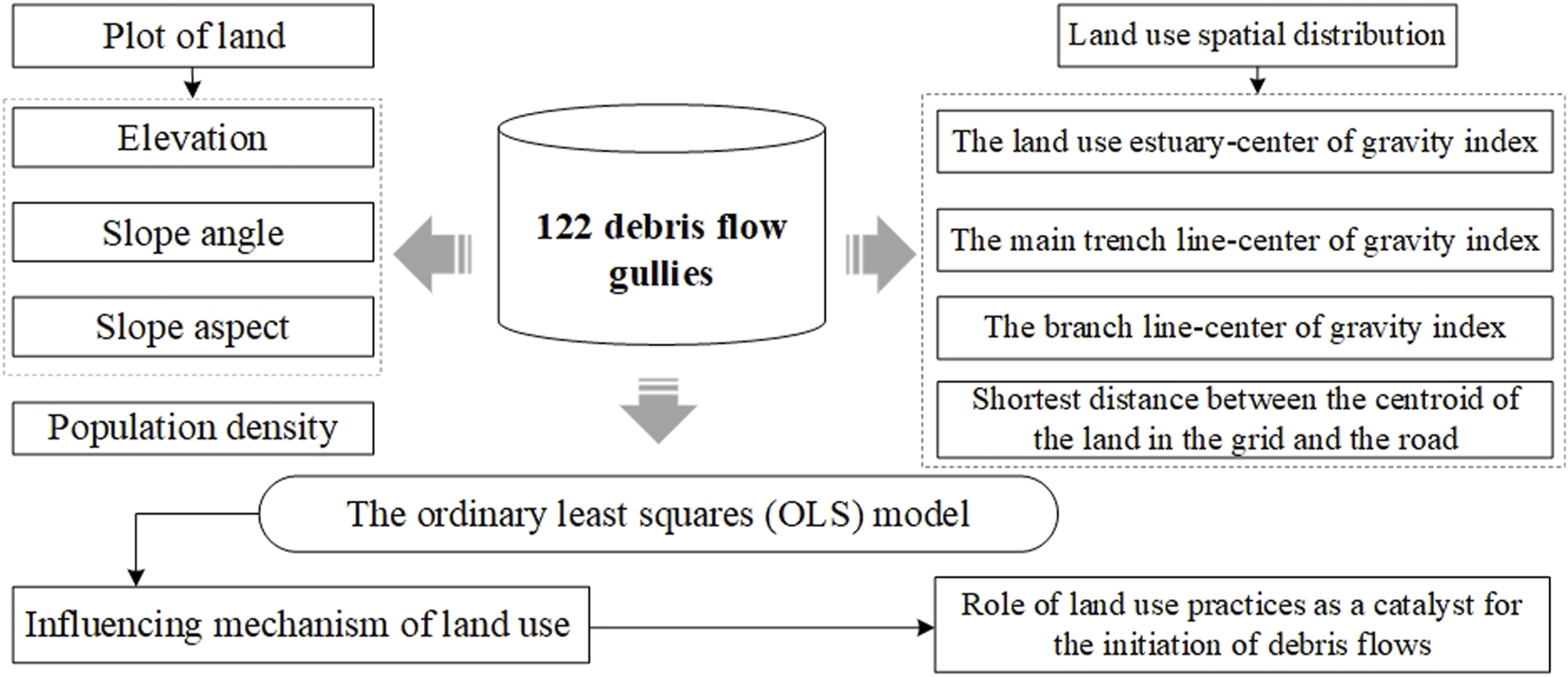
Land use in a region is shaped by a multifaceted interplay of resource availability, environmental conditions, population dynamics, economic activities, and policy frameworks (Li et al., 2021; Wang and Peng, 2022). In mountainous terrain with complex topography, land resource development is governed by the dual constraints of natural environmental factors and socio-economic drivers, particularly within spatially confined debris flow gullies (Table 1).
TABLE 1
| Types | Symbols | Indicators | Explanation of indicators |
|---|---|---|---|
| Dependent variable | Y | Land class area | Total area of the land class in the grid |
| Independent variables | X1-Dem | Elevation | Average elevation within the grid |
| X2-Slope | Slope angle | Average slope angle within the grid | |
| X3-Aspect | Slope aspect | Average slope aspect in grid | |
| X4-Dis-pri | Distance from the main trench line | Shortest distance between the centroid of the land in the grid and the main trench line of the river | |
| X5-Dis-fee | Distance from branch line | Shortest distance between the centroid of the land in the grid and the river branch line | |
| X6-Dis-road | Distance to road | Shortest distance between the centroid of the land in the grid and the road | |
| X7-Den-pop | Population density | Population density within the grid |
Variables and implications of the ordinary least squares model.
The spatial distribution of land use in such settings is primarily driven by natural conditions at the plot scale, including elevation, which dictates temperature suitability for crop growth; slope gradient, which determines agricultural feasibility, with slopes exceeding 25° prohibited for cultivation; and slope aspect, which critically influences solar exposure duration—a foundational factor for crop productivity and rural settlement patterns. The elevation, slope, and aspect data were extracted from the DEMs using a geographic information system (GIS) and statistical methods. The aspect was categorized based on the solar exposure in the Northern Hemisphere, and values of 1, 2, 3, 4, and five were assigned to north, northward, east/west, southward, and south, respectively (Figure 4).
FIGURE 4

Distribution of Influencing Factors. (a–c): Spatial distributions of (a) slope gradient, (b) slope aspect, and (c) road network.
Additionally, the proximity of land use to main or branch gullies amplifies anthropogenic disturbance and debris supply, heightening debris flow susceptibility. To quantify this relationship, distance to main gully and distance to branch gullies were selected as key indicators, which also indirectly reflect agricultural water demands. These two indicators were calculated using Euclidean distance analysis in ArcGIS 10.8, with a spatial resolution of 1:500. Social factors, such as transportation accessibility and population density, further shape land use by influencing agricultural efficiency and subsistence-driven land exploitation.
The population density was derived by converting the area of rural settlements within 100 m × 100 m grids, a spatial resolution selected to balance data precision and the spatial heterogeneity of population distribution in mountainous debris flow gullies. Based on field survey data, population counts were calculated using a standardized per capita rural settlement area of 21.23 m2, specific to Liangshan Prefecture.
However, economic and policy factors, while significant, were excluded due to the micro-scale focus of debris flow gullies and the lack of quantifiable data. Guided by principles of data quantification, spatialization, and accessibility, seven indicators—elevation, slope gradient, slope aspect, distance to main gully, distance to branch gullies, distance to roads, and population density—were systematically analyzed to elucidate the dominant factors governing land use spatial distribution in debris flow-prone gullies.
3 Methods
3.1 Overall workflow
In this study, to investigate the impact processes and mechanisms of debris flow disasters on land use, 122 debris flow gullies were selected in the Anning River Basin. Indicators were systematically derived from two dimensions: topographic attributes (e.g., elevation, slope gradient) and spatial distribution of land use (e.g., Land Use Concentration Index, LUCI). The Ordinary Least Squares (OLS) model was applied to elucidate the driving mechanisms of land use patterns. Finally, the study explored the role of land use practices in triggering debris flow events (Figure 5).
FIGURE 5
Overall workflow of study.
3.2 Land use and debris flow gully classification
3.2.1 Classification of land use types
Utilizing current land use practices and characteristics as a foundation, the land use was classified into six primary categories: cultivated land (CL), forestland (FL), grassland (GL), water bodies (WA), construction land (SL), and unutilized land (UL). Forest land can be classified into natural forest land (NF) and artificial forest land (AF). The unutilized land was further subdivided into floodplain (FP) and bare land (BL). Based on these primary classifications, secondary land use types were further delineated. Within this framework, the cultivated land was subdivided into paddy fields and dryland; the grassland was subdivided into high-coverage and low-coverage grassland; the construction land was subdivided into rural settlements and other types of construction land.
3.2.2 Classification of types of debris flow gullies
Based on existing research, we categorized the debris flow gullies based on their outbreak frequency (Du et al., 2024; Guo et al., 2024), dividing them into high-frequency debris flow gullies (HFDFGs), in which a debris flow occurred more than once every 5 years; medium-frequency debris flow gullies (MFDFGs), in which the debris flow occurrence rate was once every 20 years to 4 times every 20 years; and low-frequency debris flow gullies (LFDFGs), in which the debris flow occurrence rate was less than once every 20 years. Among the 122 surveyed debris flow gullies, 15, 37, and 70 were classified as high-frequency, medium-frequency, and low-frequency gullies, respectively.
3.3 Land use spatial distribution characteristics index
3.3.1 Land use concentration index
In areas prone to debris flows, the characteristics of the land use are reflected not only in the quantity and structure but also in the concentration and fragmentation of the land use patterns. The decentralized and centralized approaches to land use are direct manifestations of the effects of human activities on the landscape. Consequently, by constructing the land use concentration index (LUCI), in this study, we analyzed the distribution of the concentration of the land use types within the debris flow gullies. The calculation formula (Equations 1, 2) is as follows:where is the land use concentration index, is the average plot shape index, is the area of plot , is the perimeter of plot , and is the total number of plots in a certain location class. is between 0 and 1, and higher values indicate higher land use concentration. represents the average plot shape index, reflecting the regularity of plots; a higher value implies more dispersed plots and thus lower concentration levels.
3.3.2 Land use gravity center index
The center of gravity of land use, also referred to as the center of mass of land use, reflects the spatial transformation and utilization of land by human activities. In light of the characteristics of debris flow gullies, such as the complex distribution of the main ditch and branch ditches, fragmented land use, and pronounced vertical gradients, in this study, we endeavored to capture the spatial characteristics of the distribution of the land use center of gravity within the debris flow gullies. This was achieved through construction of the land use estuary-center of gravity index (E.G.,), the main trench line-center of gravity index (MG), and the branch line-center of gravity index (BG). The land use center of gravity migration model was derived from research on the distribution of the American population’s center of gravity, and it can objectively represent the spatiotemporal evolution of land use patterns (Gui et al., 2023; Guo et al., 2023). The coordinate formula (Equations 3–7) for the land use barycenter is as follows:where and are the horizontal and vertical coordinates of the center of gravity of the land use type, respectively, and are the horizontal and vertical coordinates of the center of gravity of the th land use type map patch, respectively; and is the area of the th land use type.in the above equation, is the land use estuary-center of gravity index, which is calculated as the ratio of the distance (D) from the center of gravity of a specific land use type within the gully to the gully’s outlet to the length (L) of the main gully. is the distance from the center of gravity of the land use type to the gully’s outlet, and is the length of the main gully. is the -coordinate of the gully’s outlet, is the -coordinate of the gully’s outlet, is the X-coordinate of the center of gravity of land use type , and is the -coordinate of the center of gravity of land use type . The value of varies between 0 and 1. Higher values signify that the center of gravity is located farther from the gully’s outlet, and vice versa.in the above equation, is the main gully-center of gravity index, which is calculated as the ratio of the distance from the center of gravity of a specified land use type within the gully to the main gully to the length of the main gully. is the distance from the center of gravity of the land use type to the main gully. and are the and coordinates of the point where the center of gravity of the th land use type intersects the main gully at a 90° angle, respectively. The value of ranges between 0 and 1, and higher values indicate a greater distance between the center of gravity and the main gully, and vice versa.
In the above equation, is the branch gully-center of gravity index, which is calculated as the ratio of the distance from the center of gravity of a specific land use type within the gully to the branch gully to the length of the branch gully. is the distance from the center of gravity of the land use type to the branch gully. and are the and coordinates of the point where the center of gravity of the th land type intersects with the branch gully at a 90° angle, respectively. The value of ranges between 0 and 1, and higher values signify a greater distance of the center of gravity from the branch gully, and vice versa.
3.4 Ordinary least square
The ordinary least squares (OLS) model is commonly used to assess the relationships between two or more attribute variables. Its principle is to minimize the sum of squared errors between the predicted values of the empirical regression model and the actual observed values (Wang L. et al., 2020; Zhang C. et al., 2022). Key advantages of OLS include its intuitive computational process, suitability for handling multivariate data, and capacity to rapidly identify critical influencing factors. This study aims to elucidate the impacts of factors such as elevation and slope aspect on the spatial distribution of land use, for which the principles and strengths of the OLS model align closely with the research objectives. In this study, variables with severe multicollinearity (VIF >10) were identified and excluded through the calculation of variance inflation factor (VIF) values to enhance model stability and the accuracy of parameter estimation. This model (Equation 8) is formally written as:
In this study, the dependent variable is , the independent variables are denoted by , is the number of independent variables, is the coefficient of the independent variables, and is the constant intercept. Due to their spatial dispersion, the 122 debris flow gullies were deemed to be unsuitable for holistic spatial analysis. Consequently, each gully was analyzed as an individual sample unit, and separate OLS models were constructed to quantify the effects of the various factors on the spatial distribution of the land use types. In this study, the multicollinearity among the variables was assessed using the variance inflation factor (VIF). VIF serves as a core diagnostic indicator for multicollinearity in regression models, reflecting the degree to which an independent variable is linearly explained by other variables. Higher VIF values indicate stronger linear associations between variables. Removing variables with high VIF values ensures the stability of parameter estimates and prevents the dilution of explanatory power in key variables caused by collinearity, thereby enhancing the model’s interpretability. In this study, variables exhibiting a VIF value exceeding 7.5—indicative of severe multicollinearity—were deemed to fail the diagnostic test and subsequently excluded from the model, consistent with established research practices.
4 Results
4.1 Debris flow gully investigation results
4.1.1 Area and occurrence frequency of debris flow gullies
Among the surveyed 122 debris flow gullies, 99 gullies (81.15%) have areas below 5 km2, 14 gullies (11.48%) range between 5 and 10 km2, and nine gullies (7.38%) exceed 10 km2 (Table 2). Among the 122 surveyed gullies, 15 are categorized as high-frequency, 37 as medium-frequency, and 70 as low-frequency debris flow gullies.
TABLE 2
| Area range (km2) | Number of gullies | Percentage (%) | Frequency category | Number of gullies | Percentage (%) |
|---|---|---|---|---|---|
| <5 km2 | 99 | 81.15% | High-frequency | 15 | 10.66% |
| 5∼10 km2 | 14 | 11.48% | Medium-frequency | 37 | 25.41% |
| >10 km2 | 9 | 7.38% | Low-frequency | 70 | 63.93% |
Area statistics of debris flow gullies.
4.1.2 Developmental stages of debris flow gullies
The geomorphic developmental stage of gullies is a natural condition influencing debris flow occurrence. The Area-Elevation Integral (AH) quantifies the geomorphic evolution stages by calculating the basin’s residual erosion rate. Following the AH calculation method from existing studies (Zheng et al., 2021), the AH values of the 122 gullies were computed to classify their developmental stages: senile stage (AH < 0.35), late mature stage (0.35 ≤ AH < 0.45), mature stage (0.45 ≤ AH < 0.55), early mature stage (0.55 ≤ AH < 0.65), and juvenile stage (AH ≥ 0.65). The results reveal that the average AH value across the 122 debris flow gullies is 0.58, with a minimum of 0.40 and a maximum of 0.82 (Figure 6a). AH values predominantly exceed 0.5, observed in 101 gullies (82.79%). Among the 122 gullies, none are classified as senile stage, while nine belong to the late mature stage. A total of 113 gullies (92.62%) fall into mature or younger stages: 36 gullies (29.51%) are in the mature stage, 58 (47.54%) in the early mature stage, and 19 (15.57%) in the juvenile stage (Figure 6b).
FIGURE 6

(a) AH value and (b) distribution probability of debris flow gullies.
4.2 Characteristics of the spatial distribution of land use
4.2.1 Characteristics of the vertical gradient of land use
The vertical gradient characteristics of land use in mountainous regions are pronounced. To comprehensively capture these features, this study refined the classification of slope gradient and elevation ranges. Field surveys revealed that human activities in debris flow gullies are predominantly concentrated in areas with slopes below 50°, with intensive utilization (e.g., construction and cultivated land) occurring on slopes below 20°. To reflect spatial heterogeneity, slopes below 20° were divided into two intervals (0°–10°, 10°–20°), while slopes of 20°–50° were subdivided into six intervals at 5° increments (20°–25°, 25°–30°, 30°–35°, 35°–40°, 40°–45°, and 45°–50°). Slopes exceeding 50°, largely covered by natural forests and grasslands with minimal human use, were retained as a single category. This hierarchical classification effectively delineates land use variations across slope gradients.
For elevation, the relative elevation differences across the 122 gullies range from 202 m to 2,492 m. After empirical testing, each gully was stratified into five elevation zones: the foot of the mountain, the lower half of the mountain, the middle half of the mountain, the upper half of the mountain, and the high part of the mountain. This stratification balances the need to reflect land use differences across elevation belts with operational feasibility. Finally, the spatial distribution of land use across slope and elevation gradients was derived using the Intersect tool in ArcGIS to overlay land use data with slope and elevation zone layers.
The cultivated land is most prevalent on slopes of 10°–20°, accounting for 36.60% of the total cultivated land, followed by 0°–10° slopes (25.19%). The cultivated land on the 20°–25° and 25°–30° slopes accounts for 14.94% and 12.54%, respectively, while that on the >30° slopes accounts for 10.72%. The forest land distribution exhibits an inverted U-shaped pattern, with the greatest proportion located on the 25°–40° slopes, accounting for 57.80% of the forested areas. The distribution of the grassland mirrors that of the forest land but with a lower slope center of gravity, predominantly on 10°–20° slopes. The construction land is predominantly located in the least steep areas, with 67.35% in the first and second slope grades, i.e., 38.86% on 0°–10° slopes and 28.49% on 10°–20° slopes.
According to the distributions of the various land use types across the different altitude zones, the proportion of cultivated land exhibits a clear decreasing trend with increasing elevation (Figure 7), decreasing from 50.74% at the foot of the mountain to 2.45% on the high part of the mountain. The proportion of the forested land gradually decreases from the lower half of the mountain (30.42%) to the middle half of the mountain (28.58%) to the upper half of the mountain (22.25%) to the high part of the mountain (5.54%). The grasslands are predominantly located on the lower and middle halves of the mountain, accounting for 35.07% and 32.37% of the total grassland area, respectively. The grasslands on the lower half of the mountain are predominantly high-coverage grasslands, while those on the upper half of the mountain are predominantly low-coverage grasslands. The water bodies are primarily concentrated at the foot of the mountain and in the lower half of the mountain, collectively accounting for 96.93% of the total area of the water bodies. The construction land is predominantly located at the foot of the mountain, accounting for 60.04% of the total construction land, followed by a significant reduction in the lower half of the mountain, accounting for 17.24%. The construction land in the middle and upper halves of the mountain constitute 18.91% of the total. The unused land exhibits a pattern of higher abundance at the extremities and lower abundance in the middle. The unused land at the foot of the mountain is primarily composed of floodplain areas and that on the upper half of the mountain is predominantly composed of bare land.
FIGURE 7

Vertical distribution of cultivated land in the different gullies. (a) LFDFGs, (b) MFDFGs, and (c) HFDFGs.
4.2.2 Agglomeration characteristics of spatial distribution of land use
The average LUCI values of the various land use types are ranked from highest to lowest as follows: forest land, unused land, cultivated land, grassland, and construction land. The forest land has the highest average LUCI (0.382), which is significantly higher than those of the other land use types, which is consistent with its inherently contiguous distribution in mountainous regions. The unused land has the second highest LUCI value of 0.353. The cultivated land has an average LUCI of 0.352, which is lower than that of the forest land, particularly in mountainous areas. The grassland’s average LUCI is 0.331, only surpassing that of the construction land, indicating that it exhibits a more scattered distribution within the debris flow gullies. The construction land has the lowest average LUCI value of 0.240. Because the area of water bodies is very small, it was not calculated.
The LUCI exhibits distinct differences among the different types of gullies (Figure 8). In the LFDFGs, the LUCI of the cultivated land is relatively high (average of 0.381), primarily distributed between 0.3 and 0.5. This indicates that the cultivated land has a more concentrated and contiguous distribution pattern, especially in the low-elevation areas where it typically occupies the most favorable geographic positions within the gullies. The LUCI values of the cultivated land in the MFDFGs and HFDFGs are 0.358 and 0.317, respectively. It can be seen from Figure 4 that as the frequency of debris flow occurrence increases, the LUCI of the cultivated land decreases, suggesting a more dispersed and fragmented spatial distribution. Conversely, the LUCI values of the forest land in the LFDFGs, MFDFGs, and HFDFGs are 0.334, 0.363, and 0.449, respectively. The LUCI values of the unutilized land are 0.286, 0.357, and 0.416 in the LFDFGs, MFDFGs, and HFDFGs, respectively, and there is a higher prevalence of unused land in the HFDFGs. The LUCI of the construction land increases as the frequency of debris flow occurrence increases, with values of 0.213, 0.240, and 0.266 for the LFDFGs, MFDFGs, and HFDFGs, respectively. This indicates that the land available for construction in the HFDFGs is narrower and more concentrated, particularly for the rural settlements, the distribution of which is constrained to within the limited safe areas.
FIGURE 8

Spatial concentration of land use types in debris flow gullies with different occurrence frequencies.
Analysis of the, E.G., revealed the following ranking of the land use types from highest to lowest: bare land, forest land, grassland, cultivated land, construction land, water area, and floodplains (Figure 9). The average, E.G., values for the floodplains and water bodies, which are situated near the gully outlets, are notably low (0.063 and 0.066, respectively). The construction land has an average, E.G., value of 0.254, with a total of 104 gullies exhibiting, E.G., values less than 0.50. The cultivated land has an average, E.G., value of 0.340, and 93 of the gullies have, E.G., values less than 0.50, signifying that the majority of the cultivated land within the gullies is positioned relatively close to the gully outlets. The grassland and forest land have average, E.G., values of 0.569 and 0.639, respectively. A total of 108 gullies have forest land, E.G., values greater than 0.50, indicating that the centroid of the forest land is located a relatively long distance from the gully outlets. The average, E.G., value of the bare land (0.641) is the highest among all of the land types, implying that the bare land in the gullies is predominantly located in the midstream and upstream regions, i.e., farther away from the gully outlets.
FIGURE 9

Estuary-center of gravity index in debris flow gullies.
The ranking of the MG values of the land use types is as follows: grassland > forest land > construction land > cultivated land > bare land > floodplains > water bodies (Figure 10). The average MG value of the grassland is 0.073, with 68 gullies exhibiting MG values less than 0.07 and 28 gullies exhibiting MG values greater than 0.10. This indicates that the center of gravity of the grassland is located at a greater distance from the main gully compared to that of the other land use types. The average MG value of the forest land is 0.069, with values ranging from 0.002 to 0.224. The construction land and cultivated land have average MG values of 0.049 and 0.047, respectively. The average MG value of the bare land is 0.046. The MG values also exhibit variability among the different types of gullies. For the cultivated land, the average MG values of the different types of gullies are as follows: LFDFGs (0.050) > MFDFGs (0.045) > HFDFGs (0.0331). For the forest land, the average MG values are as follows: LFDFGs (0.074) > HFDFGs (0.071) > MFDFGs (0.064). For the grassland, the average MG values for the LFDFGs, MFDFGs, and HFDFGs are 0.071, 0.080, and 0.061, respectively. The MG values of the construction land and cultivated land exhibit similar trends, that is, LFDFGs (0.055) > MFDFGs (0.045) > HFDFGs (0.030). The average MG values of the bare land for the LFDFGs, MFDFGs, and HFDFGs are 0.048, 0.045, and 0.043, respectively, with no clear pattern.
FIGURE 10

Main trench line-center of gravity index for the land use types in the different types of debris flow gullies.
The ranking of the BG values of the land use types is as follows: bare land > grassland > forest land > cultivated land > construction land > floodplains > water bodies (Figure 11). The average BG value of the bare land is 0.038, ranging from a minimum of 0.006 to a maximum of 0.106. This indicates that the center of gravity of the bare land is located at a greater distance from the tributary gullies compared to that of the other land use types. The BG values of the grassland range from 0.001 to 0.146, with an average of 0.034; and the BG values of the forest land range from 0 to 0.119, with an average of 0.033. The average BG value of the construction land is 0.024. For the forest land, the average BG values in the LFDFGs, MFDFGs, and HFDFGs are 0.035, 0.034, and 0.025, respectively. The average BG values of the construction land are LFDFGs (0.027) > MFDFGs (0.022) > HFDFGs (0.018). For the bare land, the average BG values in the LFDFGs and MFDFGs are both 0.041, while in the HFDFGs, the value is 0.029. Twenty-seven of the gullies have BG values less than 0.04, constituting 62.79% of the total number of gullies comprising bare land. This confirms the characteristic that the center of gravity of the bare land in the HFDFGs is closer to the main and tributary gullies.
FIGURE 11

Branch line-center of gravity index values for the different land use types in the different types of debris flow gullies.
4.3 Influencing mechanism of land use
4.3.1 Comprehensive factors influencing the spatial distribution of the land use types
This study developed OLS models between X1–X7 and six land use types (CL, FL, etc.), with Table 1 documenting the number of variables passing the VIF threshold (VIF <7.5) in each model (Table 3). Overall, slope and aspect demonstrated higher collinearity test pass rates in OLS models for CL, FL, GL, and SL land use types.
TABLE 3
| OLS model | Number of gullies with VIF <7.5 | ||||||
|---|---|---|---|---|---|---|---|
| X1 | X2 | X3 | X4 | X5 | X6 | X7 | |
| CL | 43 | 117 | 117 | 95 | 99 | 75 | 61 |
| FL | 43 | 117 | 112 | 100 | 103 | 25 | 63 |
| GL | 23 | 68 | 104 | 97 | 56 | 44 | 29 |
| SL | 97 | 116 | 112 | 96 | 55 | 82 | 33 |
| AF | 33 | 26 | 28 | 24 | 26 | 12 | 8 |
| BL | 22 | 62 | 56 | 58 | 61 | 21 | 18 |
Statistical results of valley counts in OLS models passing VIF test.
Figure 12 shows the regression results of the OLS model. Based on assessment of the influences of the elevation on the distribution of the cultivated land, only 43 out of the 117 gullies comprising cultivated land meet the criteria for collinearity and statistical significance (p < 0.05), accounting for 36.75% of the total samples. The Slope and Aspect variables are statistically significant across all 117 gullies. The Dis-pri, Dis-fee, Dis-road, and Den-pop are significant for 95, 99, 75, and 61 gullies, respectively. Detailed statistical examination was performed to interpret the direction of the regression coefficients for the various factors affecting the cultivated land in the tested gullies. The findings suggest that the elevation predominantly exhibits a negative relationship with the distribution of the cultivated land, with 70.46% of the gullies exhibiting negative regression coefficients. This implies that as the elevation increases, the likelihood of finding cultivated land decreases. The regression coefficients for the slope were negative in 93.16% of the gullies, indicating a general trend of steeper slopes with less cultivated land. The aspect coefficients were evenly distributed between positive and negative values, signifying that the influence of the aspect on the cultivated land distribution varies significantly across the different gullies. For the Dis-road variable, the gullies with negative regression coefficients account for 60.00% of the samples, implying a strong correlation between the proximity to roads and the presence of cultivated land in the majority of the gullies. The relationship between the population density and cultivated land distribution is positive in 88.53% of the gullies, suggesting that the areas with higher population densities are more likely to have cultivated land.
FIGURE 12

Ordinary least squares coefficients. (a–f) are the OLS regression results of CL, FL, GL, SL, AF, and BF with the seven impact factors, respectively.
Regarding the analysis of the factors affecting the distribution of the forest land, a significant finding is that only 43 gullies, approximately one-third of the total, passed the significance test for elevation (obtained from the DEM). Among these gullies, 30 have positive regression coefficients, representing 69.77% of the tested gullies. This is inconsistent with the distribution of the cultivated land, i.e., higher elevations typically correspond to less cultivated land. The Den-pop variable is significant in only 63 gullies, corresponding to a pass rate of 51.64%, and 82.54% of these gullies have negative regression coefficients. This suggests that regions with higher population densities are less likely to be covered by forest land. The Slope variable is significant across all of the gullies, with a positive regression coefficient in 92.62% of the gullies. This indicates that forest land is more prevalent in areas with steeper slopes, which may be due to the unsuitability of such terrain for other types of land use. The Aspect variable is significant in 112 gullies. Unlike the observed pattern of the cultivated land, there is a notable negative correlation between the aspect and distribution of the forest land, implying that certain aspects are less conducive to forestation. The Dis-pri and Dis-fee variables are significant in 100 and 103 gullies, respectively. Approximately 50% of these gullies have negative regression coefficients, suggesting that proximity to these features is inversely related to the distribution of the forest land.
Analysis of the spatial distribution of the construction land revealed that the Dem variable is a significant factor, passing the test in 91 gullies, which is the highest occurrence among all of the land use types analyzed. The regression coefficients are negative in three-quarters of these gullies, with an average value of −0.84. This finding indicates the occurrence of a predominantly inverse relationship between the elevation and the distribution of the construction land, suggesting that higher elevations are less likely to be developed for construction purposes. The Slope variable is significant in 116 gullies, and the regression coefficients are negative in 96.55% of the gullies. This demonstrates that there is a strong negative correlation between the presence of construction land and the steepness of the slope, which is consistent with the general preference for flatter areas for construction due to ease of development and accessibility. The Dis-pri variable is significant in 96 gullies, with 85.42% exhibiting negative regression coefficients. This finding reflects the reliance of rural settlement layouts on proximity to water sources. The Dis-road variable is significant in 82 gullies, and the regression coefficients are negative in 89.02% of these gullies. According to the above results, slope, elevation, and distance to roads are the predominant factors influencing the spatial distribution of the construction land.
A total of 28 gullies are characterized by artificial forest land, and the slope is a significant factor in 26 of these gullies. Approximately 68% of these gullies exhibit a negative correlation with slope. The aspect is significant in all 28 gullies, with about 71% exhibiting a positive correlation. The Dis-pri and Dis-fee variables are significant in 24 and 26 gullies, respectively, and both exhibit negative correlations in more than 70% of these gullies. The influences of the Dem, Dis-road, and Den-pop on the distribution of the artificial forest land are statistically insignificant. Among the 65 gullies comprising bare land, the elevation is only significant in 22. The Slope and Aspect are significant in 62 and 56 gullies, respectively, and the regression coefficients are positive in 73.85% and 70.77% of these gullies, indicating a predominantly positive correlation between the distribution of the bare land and these two factors. The Dis-pri and Dis-fee variables are significant in 58 and 61 gullies, respectively, and the regression coefficients are negative in 65% and 74% of these gullies.
4.3.2 Different mechanisms of influence in the different types of gullies
The relationships between the various variables and the land use patterns across the distinct types of gullies were evaluated individually (Figure 13).
FIGURE 13

Relationship between variable factors and land use types.
For the cultivated land, the influence of the elevation (Dem) is strongest in the MFDFGs and weakest in the HFDFGs, with positive correlation rates of 50.00% and 20.00%, respectively. The ranking of the negative effect of the slope in the gullies is as follows: LFDFGs (100.00%) > MFDFGs (94.59%) > HFDFGs (91.91%). Among the factors influencing the grassland distribution, the Dem, Slope, and Dis-fee exhibit predominantly positive correlations with the grassland distribution in the MFDFGs and HFDFGs, while the Aspect and Dis-pri exhibit more pronounced positive correlations in the LFDFGs. The ranking of the positive influence of the Dem is as follows: MFDFGs (57.89%) > HFDFGs (57.14%) > LFDFGs (28.57%), and the Dis-road exhibits more positive correlations in the HFDFGs. For the artificial forest land, the influence of the Dem is positively correlated in all of the LFDFGs. Additionally, the Dis-pri and Dis-fee have higher rates of positive correlations in the MFDFGs, with positive values in 100.00% and 66.67%, respectively.
For the bare land, the DEM exhibits a more pronounced positive correlation in the MFDFGs, accounting for 42.86% of the variance. The effect of Slope on the bare land is largely negative, and the extent of the negative correlation decreases in the following order: LFDFGs (83.34%) > MFDFGs (79.95%) > HFDFGs (67.65%). In contrast, the Aspect predominantly exhibits a positive correlation, with an average of 73.91%, and the degree of the positive correlation is ranked as follows: LFDFGs (83.33%) > MFDFGs (73.68%) > HFDFGs (64.71%). The positive influence of the Dis-pri on the bare land is ranked as follows: HFDFGs (44.83%) > MFDFGs (26.67%) > LFDFGs (22.22%). Conversely, the positive effect of the Den-pop on the bare land is ranked as follows: LFDFGs (66.67%) > MFDFGs (60.00%) > HFDFGs (40.00%). This indicates that in gullies with higher occurrence frequencies, the population tends to be in closer proximity to the bare land.
5 Discussion
5.1 Different influences on the distribution of land use
Elevation and slope are intrinsic natural factors that significantly influence the spatial configuration of the land use within debris flow gullies. In this study, we found that while the percentage of the gullies that passed the collinearity test for elevation is modest, this does not imply that elevation plays a negligible role in the distribution of land use types. On the contrary, there is a notable negative correlation between the elevation and the occurrence of construction land, with lower-elevation zones emerging as the focal areas for construction activities and a marked reduction in the amount of construction land at higher elevations. This observation aligns with the results reported in previous studies (Peña-Angulo et al., 2019; Zhang H. et al., 2022; Chen, 2023). In regions with higher elevations, challenges such as difficult transportation access, scarce water resources, and cooler temperatures serve as critical constraints on both industrial and residential development. Nevertheless, in mountainous terrain where arable land is at a premium, even the rare occurrence of level ground at high elevations can serve as a magnet for farmers seeking to establish settlements and pursue agricultural endeavors. This phenomenon offers an explanation for the persistence of land use at higher elevations, countering the expected trend of decreasing land use with elevation.
Slope is a critical factor that governs the spatial distribution of land use types within debris-flow gullies. In mountainous regions, which are susceptible to frequent debris flows and are characterized by pronounced topographic variability and a scarcity of level ground, the increasing population pressure necessitates the expansion of agricultural activities onto slopes of greater steepness. This is in stark contrast to the spatial distribution patterns of the land use types observed in regions with plains and more gently rolling hills (Lai et al., 2020; Zhang J. J. Y. et al., 2022). Cultivation on steep slopes can lead to destabilization of the terrain, potentially triggering natural disasters such as slope failure and landslides. Beyond a certain slope threshold, the use of land for human settlement and agricultural purposes becomes impractical (He et al., 2024). It is clear that the slope exerts a dominant influence on the overall land use pattern within debris flow gullies and the surrounding mountainous landscapes. The effect of slope on the distribution of the land allocated for production and habitation is predominantly negative. Specifically, with increasing slope, there is a marked reduction in the amounts of both cultivated and construction land. Furthermore, the intensity and spatial reach of the slope’s impact on land use patterns differ among gullies with varying frequencies of debris flow occurrence. Consequently, it is imperative to categorize gullies based on their debris flow frequency to gain a more nuanced understanding of the spatial patterns of land use.
The aspect plays a pivotal role in governing the distribution of forest, grassland, and bare land. The impact of the slope aspect on the distribution of land use types is largely mediated by the quantity of solar radiation received, which in turn influences the surface vegetation dynamics. Moreover, the aspect is a critical consideration in the planning and construction of residential housing (Liu Y. et al., 2020). Within debris-flow gullies characterized by relatively benign terrain conditions (i.e., LFDFGs), the proportion of positive regression coefficients between the slope aspect and cultivated land is higher. This suggests that in gullies with more favorable topography, agriculturalists prefer sunlit aspects for farming activities, which is in accordance with the basic tenets of agricultural production (He et al., 2020). Interestingly, there is a significant positive correlation between the distributions of the slope aspects and bare land, particularly in debris-flow gullies with rugged terrain conditions (HFDFGs). The underlying cause of this pattern may be the increased intensity of solar radiation on sunward-facing slopes, which can lead to the formation of tensile fissures in bare soil, potentially contributing to debris flow initiation. Additionally, there is a marked negative correlation between the distributions of artificial forest land and the slope aspect, indicating a preference for sunlit slopes for afforestation efforts. This distribution pattern is influenced by the region’s high incidence of natural disasters and the government’s policy of converting agricultural land to forest, which has resulted in the replacement of some sunward-facing cultivated land with economically valuable tree crops, such as walnuts and peppers, thereby shaping the observed distribution pattern.
The constraint of water availability on the distributions of cultivated and construction land is pronounced. Based on statistical testing, both the proximity to the main ditch and the proximity to the branch ditch are significant. However, interestingly, the influences of these two distances on the spatial distribution of the construction land differ. The negative correlation between the distance from the main ditch and the proportion of the construction land is particularly striking, suggesting that the placement of construction land, primarily rural residential areas, is more heavily influenced by the proximity to water sources. In the context of debris flow gullies in mountainous regions, the scarcity of perennially flowing streams is notable, and only certain main ditches retain water flow during the winter months, while tributary gullies typically experience seasonal drying. This uneven temporal distribution of water resources creates a critical reliance of human activities on water availability, with agricultural land situated farther from water sources often necessitating winter fallow periods and spring droughts delaying planting schedules. Concurrently, human settlement and construction patterns exhibit a stronger dependence on water resources than agricultural activities, especially during winter when substantial groundwater reserves are essential to offset the absence of surface water. As a result, residential and construction land is preferentially located near the main ditch, which not only supports the use of surface runoff for agricultural purposes but also ensures access to water for daily living requirements.
Land use change in the Anning River Basin has been driven by multiple factors, including economic growth, migration of rural population to urban areas, shifts in land management policies, and climate warming (Zhou et al., 2020). However, the primary driving forces varied significantly depending on both land use type and geographical location (Meng et al., 2021). Some studies reveal that population growth and economic development served as the dominant drivers for the conversion of cultivated land into built-up areas. In contrast, the transformation of cultivated land to forest and grassland was primarily influenced by geographical environmental factors, particularly terrain and slope characteristics (Zhou et al., 2020). The terrain plays a fundamental role in shaping regional ecosystems by determining the spatial distribution of water, heat, and soil nutrients. Furthermore, geological disaster can significantly alter these biophysical factors, thereby exerting profound impacts on both the patterns and intensity of human land use activities (Munteanu et al., 2014). It is important to recognize that land use change represents a complex, nonlinear process where the interplay between anthropogenic and natural factors constitutes the fundamental mechanism driving these transformations (Sisay et al., 2021). While policy-oriented factors represent the most dynamic and primary driver of long-term land use modification, their effects are typically more straightforward to identify. For instance, the substantial influence of terrain and slope gradients on nearly all land use types is clearly demonstrated in China’s policy prohibiting crop cultivation on slopes exceeding 25° (Deng et al., 2017). Nevertheless, future research should pay particular attention to two critical aspects: the temporal lag in policy impacts and the actual implementation effectiveness of land use policies. These considerations are essential for developing more accurate models of land use change dynamics in disaster prone areas.
5.2 Role of land use practices as a catalyst for the initiation of debris flows
Hillslope debris flows result from a complex interplay between environmental factors (lithology, gradient, hillslope morphology, vegetation cover, and microtopography) and anthropogenic influences (land use patterns) under specific precipitation conditions (Zhao et al., 2021). In the Anning River Basin, as in most areas of Southwest China, the relative contribution of these factors to debris flow formation follows this hierarchy: relative height difference > precipitation > main channel slope > land use > vegetation cover > longitudinal slope ratio > main channel length (Wang Y. et al., 2020). The formation of debris flows requires three essential conditions: energy, material, and water source (Wei et al., 2008). The energy conditions are primarily governed by topographic features, including relative relief and slope gradient. Relative relief determines the potential energy, while slope gradient facilitates energy transformation for debris flow movement. The study area exhibits significant elevation variations, with substantial terrain fluctuations creating an unstable geomorphic structure. This provides the necessary potential energy for debris flow materials and establishes a foundation for the occurrence of geological disasters. Vegetation cover plays a crucial role in regulating debris flow initiation. Well-vegetated areas exhibit lower accumulation rates of unconsolidated material compared to sparsely vegetated or barren slopes. Human activities, such as mining and road construction, further influence slope stability by altering ground cover, soil structure, and the availability of loose debris. In the Anning River Basin, steep slopes and abundant loose debris create favorable topographic and material conditions for debris flows (Liu et al., 2016). While vegetation cover serves as a single indicator reflecting natural conditions, human impacts are more complex and cannot be easily quantified by a single metric. However, land use patterns effectively capture both natural and anthropogenic influences. Land use is another factor affecting slope stability, with cultivated lands exhibiting higher susceptibility to landslides and debris flows compared to forested areas (Zhang et al., 2019). Previous studies support these findings, demonstrating that converting natural vegetation—particularly forests—to cultivated land or abandoning cultivated land can significantly reduce slope stability by increasing surface runoff, accelerating erosion, and destabilizing soil (Lopez-Saez et al., 2016; Persichillo et al., 2017). Moreover, forested slopes demonstrate greater stability than those with herbaceous vegetation due to the deeper root systems of woody plants, which enhance soil moisture regulation and slope reinforcement (Kim et al., 2017). These insights underscore the importance of integrated land management strategies in mitigating debris flow risks in vulnerable regions like the Anning River Basin. In addition, the gully environment not only provides the fundamental conditions necessary for debris flow initiation but also amplifies the impact by governing land use patterns. In different types of gullies, variations in how the gully environment controls the distribution of the land use types result in indirect differences in the extent to which land use triggers debris flows.
In LFDFGs, the overall gentler slope gradient makes it more likely for cultivated land to extend toward the upper half of the mountain and the high part of the mountain. The areas above some LFDFGs even feature extensive flat terrain, which has been converted by farmers into cultivated land and in some instances, into villages or residential areas. This development provides favorable conditions for debris flow formation. The initiation of debris flows in these developed areas can be attributed to two primary aspects. 1) Agricultural activities, such as periodic irrigation, watering, and soil loosening, accelerate the process of surface erosion, supplying loose sediment, which is essential for debris flow formation (He et al., 2022). Furthermore, the lower sections of cultivated slopes are often forested areas with steeper gradients. Water from irrigation and watering at the top of the slope can percolate through the soil pores, saturating the slope body and potentially triggering landslides. These landslides contribute to an increase in the amount of loose material within the gully, which can ultimately lead to debris flows (Chen et al., 2015). 2) The construction of residential areas and transportation routes on hilltops results in a significant amount of discarded soil and debris. This can damage the vegetation on and the surface structure of the slope or the lower section of the hillside, leading to slope instability (Lee S. et al., 2024), as well as the formation of loose soil and debris (Sun et al., 2021), consequently providing a substantial source of material for debris flows.
Under the influence of gully environment conditions, the spatial extent over which land use can potentially trigger debris flows is broader in MFDFGs than in LFDFGs. As in LFDFGs, taking advantage of the gentler slopes of the level areas at the crest of the high part of the mountain in MFDFGs, residents utilize these areas for agricultural activities, residential development, and the construction of transportation routes. This leads to downslope movement of solid loose materials into the gully beds, thereby significantly increasing the material source for debris flows. Unlike in LFDFGs, the lower elevation areas in MFDFGs are constrained by the topographic conditions, which limit the area available for development. Although the middle half of the mountain is unsuitable for agricultural cultivation due to the scarcity of flat land, these sloping areas are nonetheless developed into cultivated land by farmers to achieve agricultural production (He et al., 2021). The statistical data indicate that 49 of the gullies consist of cultivated land on the middle half of the mountain, accounting for 70.00% of the total number of MFDFGs. This may be a significant factor through which land use contributes to the initiation of debris flows in MFDFGs.
In HFDFGs, the space available for agricultural production and residential construction is significantly more constrained compared to the other two types of gullies. Consequently, the impact of human activities on debris flows is correspondingly lower. The predominant factors contributing to debris flow occurrence in HFDFGs are the gully environment and rainfall conditions (Cui et al., 2011). This suggests that in HFDFGs, the proportion of land use types characterized by significant human disturbance, such as cultivated land, rural residential areas, and transportation construction land, is smaller at higher elevations. These land use types contribute only minimally to the material source and reduce the potential for triggering debris flows. This is in contrast to the situation in LFDFGs. The land use types with a significant potential to induce debris flows in HFDFGs are forested grasslands and bare land with steep slopes. There are two primary reasons for this. First, in areas with steep slopes, the weight of tall trees can enhance slope instability, potentially intensifying landslides and debris flows (Schmaltz and Mergili, 2018). Second, there is a notable correlation between steep bare slopes and debris flow occurrence, as human or natural surface modifications and vegetation destruction create exposed environments, which are detrimental to slope stability (Li et al., 2015; Zhou et al., 2015). Under the direct impacts of rainfall and erosion, these areas are more susceptible to collapses and landslides, which contribute to the material source of debris flow activities.
5.3 Limitations and research prospects
Our research, grounded in empirical data for 122 debris flow gullies within the Anning River Basin, elucidates the characteristics and underlying mechanisms of the land use distribution, as well as the interplay between land use practices and debris flow occurrence. The primary research method used involves conducting horizontal comparisons across homologous gullies to discern the fundamental patterns of land use within debris flow-prone areas. Nonetheless, the inherent variability of the natural environments among the debris flow gullies prevents the lateral comparison method from providing an absolute assessment of the impact of land use on debris flows. Future research could enhance the understanding of this topic by developing long-term observation datasets that track the evolution of both land use and debris flow phenomena. In addition, this investigation was focused at the micro-scale, and the land use attributes of representative debris flow gullies were analyzed. While this approach maintains the integrity of the natural gully units and authentically captures the relationship between the land use within the gullies and debris flows, it is imperative to acknowledge the influences of meso-scale and macro-scale factors, such as the climate, topography, and policies, on land use distribution patterns. These broader-scale influences warrant further exploration to complement the micro-scale analysis.
6 Conclusion
Utilizing a dataset of 122 debris flow gullies within the Anning River Basin in China as the research sample, in this study, we investigated the spatial distribution characteristics of the land use types within these gullies, quantitatively evaluated the determinants of the land use distribution, and explored the interplay between the land use patterns and debris flow occurrence. The findings suggest that the land use structure within the debris flow gullies is characterized by its uniqueness and complex spatial arrangement. The amount of cultivated land decreases with increasing altitude, whereas the amount of forest land initially increases and then decreases on the steeper slopes. The construction land is predominantly concentrated in the piedmont regions. Moreover, the spatial distribution of the land use types in the debris flow gullies is fundamentally governed by the natural conditions, and the slope angle and altitude are the primary controlling factors. The aspect exerts a significant influence on the distributions of the forest land, grassland, and bare land, while the availability of water sources and the presence of roads act as constraints on the distributions of the cultivated land and construction land. The spatial configuration of the cultivated land is associated with the population distribution pattern. In this study, we also examined the different impacts of various land use types on the initiation of debris flows in different types of gullies. In the LFDFGs, the land use types that caused more disturbances, such as cultivated land and construction land, were found to have a triggering effect on debris flows. In contrast, within the HFDFGs, the roles of the forest land, grassland, and bare land on the steep slopes in exacerbating debris flows were more pronounced. The results of this research offer critical insights for the development of disaster mitigation strategies and for land use planning in regions prone to debris flow events.
Statements
Data availability statement
The raw data supporting the conclusions of this article will be made available by the authors, without undue reservation.
Ethics statement
Ethical review and approval was not required for the study on human participants in accordance with the local legislation and institutional requirements. Written informed consent from the patients/participants OR patients/participants legal guardian/next of kin was not required to participate in this study in accordance with the national legislation and the institutional requirements.
Author contributions
XL: Conceptualization, Writing – original draft, Writing – review and editing. RZ: Data curation, Formal Analysis, Investigation, Validation, Writing – review and editing. HZ: Writing – review and editing, Software, Data curation, Methodology, Investigation, Visualization. XZ: Writing – review and editing, Data curation, Validation, Funding acquisition.
Funding
The author(s) declare that financial support was received for the research and/or publication of this article. This research was funded by the Sichuan Philosophy and Social Science Foundation project (Grant No. SCJJ23ND427), the National Natural Science Foundation of China (Grant No. 42401354, 42301229).
Conflict of interest
The authors declare that the research was conducted in the absence of any commercial or financial relationships that could be construed as a potential conflict of interest.
Generative AI statement
The author(s) declare that no Generative AI was used in the creation of this manuscript.
Publisher’s note
All claims expressed in this article are solely those of the authors and do not necessarily represent those of their affiliated organizations, or those of the publisher, the editors and the reviewers. Any product that may be evaluated in this article, or claim that may be made by its manufacturer, is not guaranteed or endorsed by the publisher.
References
1
Al Maamari R. H. H. (2024). Enhancing resilience to climate events: a multi-capital approach in social work. Int. J. Disaster Risk Reduct.113, 104883. 10.1016/j.ijdrr.2024.104883
2
Baggio T. Martini M. Bettella F. D Agostino V. (2024). Debris flow and debris flood hazard assessment in mountain catchments. Catena (Giessen)245, 108338. 10.1016/j.catena.2024.108338
3
Bregoli F. Medina V. Chevalier G. Hürlimann M. Bateman A. (2015). Debris-flow susceptibility assessment at regional scale: validation on an alpine environment. Landslides12, 437–454. 10.1007/s10346-014-0493-x
4
Chen G. (2023). Comparative spatial distribution simulation of plateau mountain cultivated land based on spatial multi-scale model, yunnan central urban agglomeration area, China. Pol. J. Environ. Stud.32, 3063–3080. 10.15244/pjoes/161379
5
Chen J. Li Y. Zhou W. Iqbal J. Cui Z. (2017). Debris-flow susceptibility assessment model and its application in semiarid mountainous areas of the southeastern Tibetan plateau. Nat. Hazards Rev.18, 5016005. 10.1061/(ASCE)NH.1527-6996.0000229
6
Chen N. Chen M. Li J. He N. Deng M. Iqbal Tanoli J. et al (2015). Effects of human activity on erosion, sedimentation and debris flow activity - a case study of the qionghai lake watershed, southeastern Tibetan plateau, China. Holocene25, 973–988. 10.1177/0959683615574893
7
Cui P. Chen X. Zhu Y. Su F. Wei F. Han Y. S. et al (2011). The wenchuan earthquake (may 12, 2008), sichuan province, China, and resulting geohazards. Nat. Hazards Dordr.56, 19–36. 10.1007/s11069-009-9392-1
8
Cui P. Ge Y. Li S. Li Z. Xu X. Zhou G. G. et al (2022). Scientific challenges in disaster risk reduction for the sichuan–tibet railway. Eng. Geol.309, 106837. 10.1016/j.enggeo.2022.106837
9
Dash R. K. Falae P. O. Kanungo D. P. (2022). Debris flow susceptibility zonation using statistical models in parts of northwest indian himalayas—implementation, validation, and comparative evaluation. Nat. Hazards111, 2011–2058. 10.1007/s11069-021-05128-3
10
Deng L. Liu S. Kim D. G. Peng C. Sweeney S. Shangguan Z. (2017). Past and future carbon sequestration benefits of China’s grain for green program. Glob. Environ. Change47, 13–20. 10.1016/j.gloenvcha.2017.09.006
11
Du Y. Liu H. Li H. Xie M. Chicas S. D. Wu J. et al (2024). Exploring the initiating mechanism, monitoring equipment and warning indicators of gully-type debris flow for disaster reduction: a review. Nat. Hazards120, 13667–13692. 10.1007/s11069-024-06742-7
12
Gui D. He H. Liu C. Han S. (2023). Spatio-temporal dynamic evolution of carbon emissions from land use change in guangdong province, China, 2000–2020. Ecol. Indic.156, 111131. 10.1016/j.ecolind.2023.111131
13
Guo B. Yang F. Fan Y. Zang W. (2023). The dominant driving factors of rocky desertification and their variations in typical mountainous karst areas of southwest China in the context of global change. Catena220, 106674. 10.1016/j.catena.2022.106674
14
Guo X. Hürlimann M. Cui P. Chen X. Li Y. (2024). Monitoring cases of rainfall-induced debris flows in China. Landslides21, 2447–2466. 10.1007/s10346-024-02316-7
15
He S. Wang D. Li Y. Fang Y. Lan H. Chen W. (2019). Implementation of a landscape ecological use pattern model: debris flow waste-shoal land use in the yeyatang basin, yunnan province, China. Land Use Policy81, 483–492. 10.1016/j.landusepol.2018.11.024
16
He S. Wang D. Li Y. Zhao P. Lan H. Chen W. et al (2021). Social-ecological system resilience of debris flow alluvial fans in the awang basin, China. J. Environ. Manag.286, 112230. 10.1016/j.jenvman.2021.112230
17
He S. Wang D. Zhao P. Chen W. Li Y. Chen X. et al (2022). Dynamic simulation of debris flow waste‐shoal land use based on an integrated system dynamics–geographic information systems model. Land Degrad. and Dev.33, 2062–2075. 10.1002/ldr.4298
18
He S. Wang D. Zhao P. Li Y. Lan H. Chen W. et al (2020). A review and prospects of debris flow waste-shoal land use in typical debris flow areas, China. Land Use Policy99, 105064. 10.1016/j.landusepol.2020.105064
19
He S. Yang H. Chen X. Wang D. Lin Y. Pei Z. et al (2024). Ecosystem sensitivity and landscape vulnerability of debris flow waste-shoal land under development and utilization changes. Ecol. Indic.158, 111335. 10.1016/j.ecolind.2023.111335
20
He Z. Zhang X. Bao S. Qiao Y. Sheng Y. Liu X. et al (2015). Multiple climatic cycles imprinted on regional uplift-controlled fluvial terraces in the lower yalong river and anning river, se Tibetan plateau. Geomorphology250, 95–112. 10.1016/j.geomorph.2015.08.010
21
Hu X. Shen Y. Hu K. Xu W. Liu D. He S. et al (2024a). Quantifying the impact of earthquakes and geological factors on spatial heterogeneity of debris-flow prone areas: a case study in the hengduan mountains. J. Mt. Sci.21, 1522–1533. 10.1007/s11629-023-8320-2
22
Hu X. Wang J. Hu J. Hu K. Zhou L. Liu W. (2024b). Probabilistic identification of debris flow source areas in the wenchuan earthquake-affected region of China based on bayesian geomorphology. Environ. Earth Sci.83, 528. 10.1007/s12665-024-11833-6
23
Ji C. Yang H. Li X. Pei X. Li M. Yuan H. et al (2024). Forest wildfire risk assessment of anning river valley in sichuan province based on driving factors with multi-source data. Forests15, 1523. 10.3390/f15091523
24
Kang S. Lee S. (2018). Debris flow susceptibility assessment based on an empirical approach in the central region of South Korea. Geomorphology308, 1–12. 10.1016/j.geomorph.2018.01.025
25
Kim J. H. Fourcaud T. Jourdan C. Maeght J. L. Mao Z. Metayer J. et al (2017). Vegetation as a driver of temporal variations in slope stability: the impact of hydrological processes. Geophys. Res. Lett.44, 4897–4907. 10.1002/2017gl073174
26
Lai Z. Chen M. Liu T. (2020). Changes in and prospects for cultivated land use since the reform and opening up in China. Land Use Policy97, 104781. 10.1016/j.landusepol.2020.104781
27
Lee J. Song C. Pradhan A. M. S. Ha Y. Kim Y. (2024a). Development of structural type-based physical vulnerability curves to debris flow using numerical analysis and regression model. Int. J. Disaster Risk Reduct.106, 104431. 10.1016/j.ijdrr.2024.104431
28
Lee S. An H. Kim M. Lee D. Lee J. (2024b). Debris flows analysis through quantitative evaluation of soil depth distribution under limited data. Catena246, 108379. 10.1016/j.catena.2024.108379
29
Li L. Yu B. Zhu Y. Chu S. Wu Y. (2015). Topographical factors in the formation of gully-type debris flows in longxi river catchment, sichuan, China. Environ. Earth Sci.73, 4385–4398. 10.1007/s12665-014-3722-7
30
Li Y. Shen J. Huang M. Peng Z. (2023). Debris flow classification and risk assessment based on combination weighting method and cluster analysis: a case study of debris flow clusters in longmenshan town, pengzhou, China. Appl. Sci.13, 7551. 10.3390/app13137551
31
Li Y. Zheng B. Guo S. Zou Y. Zhang Y. Han X. et al (2024). Assessment of debris flow risk in Mentougou district, Beijing, based on runout of potential debris flow. Front. Earth Sci. (Lausanne)12. 10.3389/feart.2024.1426980
32
Li Z. Jiao L. Zhang B. Xu G. Liu J. (2021). Understanding the pattern and mechanism of spatial concentration of urban land use, population and economic activities: a case study in wuhan, China. Geo-Spatial Inf. Sci.24, 678–694. 10.1080/10095020.2021.1978276
33
Lin J. Chao J. Lin C. (2022a). Evaluation of community resilience to debris-flow disasters: a case study of nantou, taiwan. Int. J. Disaster Risk Reduct.81, 103258. 10.1016/j.ijdrr.2022.103258
34
Lin Q. Steger S. Pittore M. Zhang J. Wang L. Jiang T. et al (2022b). Evaluation of potential changes in landslide susceptibility and landslide occurrence frequency in China under climate change. Sci. Total Environ.850, 158049. 10.1016/j.scitotenv.2022.158049
35
Lina H. van Westen C. Rajaneesh A. Sajinkumar K. S. Martha T. R. Jaiswal P. (2022). Evaluating the relation between land use changes and the 2018 landslide disaster in Kerala, India. Catena (Giessen)216, 106363. 10.1016/j.catena.2022.106363
36
Liu C. Wang B. (2024). Gully-type debris flow susceptibility assessment based on a multi-channel multi-scale residual network fusing multi-source data: a case study of nujiang prefecture. All Earth36, 1–18. 10.1080/27669645.2023.2292311
37
Liu J. Jin X. Xu W. Gu Z. Yang X. Ren J. et al (2020a). A new framework of land use efficiency for the coordination among food, economy and ecology in regional development. Sci. Total Environ.710, 135670. 10.1016/j.scitotenv.2019.135670
38
Liu X. Tang C. Ni H. Y. Zhao Y. (2016). Geomorphologic analysis and physico-dynamic characteristics of Zhatai-Gully debris flows in SW China. J. Mt. Sci.13, 137–145. 10.1007/s11629-014-3267-y
39
Liu Y. Deng W. Peng L. (2020b). The coupling mechanism between the suitable space and rural settlements considering the effect of mountain hazards in the upper minjiang river basin. J. Mt. Sci.17, 2774–2783. 10.1007/s11629-019-5909-6
40
Long N. T. De Smedt F. (2019). Analysis and mapping of rainfall-induced landslide susceptibility in a luoi district, thua thien hue province, vietnam. Water11, 51. 10.3390/w11010051
41
Lopez-Saez J. Corona C. Eckert N. Stoffel M. Bourrier F. Berger F. (2016). Impacts of land-use and landcover changes on rockfall propagation: insights from the Grenoble conurbation. Sci. Total Environ.547, 345–355. 10.1016/j.scitotenv.2015.12.148
42
Lorente A. García-Ruiz J. M. Beguería S. Arnáez J. (2002). Factors explaining the spatial distribution of hillslope debris flows. Mt. Res. Dev.22, 32–39. 10.1659/0276-4741(2002)022[0032:fetsdo]2.0.co;2
43
Luo Y. Fan X. Huang R. Wang Y. Yunus A. P. Havenith H. (2020). Topographic and near-surface stratigraphic amplification of the seismic response of a mountain slope revealed by field monitoring and numerical simulations. Eng. Geol.271, 105607. 10.1016/j.enggeo.2020.105607
44
Ma B. Zhou R. Zhang F. Ru H. Li Y. Xu B. et al (2024). Relative influence of local habitat and land use/cover on the taxonomic and functional organizations of fish assemblages in the anning river, southwest China. Ecol. Indic.159, 111673. 10.1016/j.ecolind.2024.111673
45
Meng Y. Yang M. Liu S. Mou Y. Peng C. Zhou X. (2021). Quantitative assessment of the importance of bio-physical drivers of land cover change based on a random forest method. Ecol. Inf.61, 101204. 10.1016/j.ecoinf.2020.101204
46
Miao C. Liu X. (2020). Characterization of acceptable risk for debris flows in China: comparison in debris-flow prone areas and nonprone areas. Int. J. Disaster Risk Reduct.42, 101405. 10.1016/j.ijdrr.2019.101405
47
Munteanu C. Kuemmerle T. Boltiziar M. Butsic V. Gimmi U. Halada L. et al (2014). Forest and agricultural land change in the Carpathian region—a meta-analysis of long-term patterns and drivers of change. Land Use Policy38, 685–697. 10.1016/j.landusepol.2014.01.012
48
Pei Y. Qiu H. Yang D. Liu Z. Ma S. Li J. et al (2023). Increasing landslide activity in the taxkorgan river basin (eastern pamirs plateau, China) driven by climate change. Catena223, 106911. 10.1016/j.catena.2023.106911
49
Peña-Angulo D. Khorchani M. Errea P. Lasanta T. Martínez-Arnáiz M. Nadal-Romero E. (2019). Factors explaining the diversity of land cover in abandoned fields in a mediterranean mountain area. Catena181, 104064. 10.1016/j.catena.2019.05.010
50
Persichillo M. G. Bordoni M. Meisina C. (2017). The role of land use changes in the distribution of shallow landslides. Sci. Total Environ.574, 924–937. 10.1016/j.scitotenv.2016.09.125
51
Qing F. Zhao Y. Meng X. Su X. Qi T. Yue D. (2020). Application of machine learning to debris flow susceptibility mapping along the China–pakistan karakoram highway. Remote Sens.12, 2933. 10.3390/rs12182933
52
Qiu C. Su L. Pasuto A. Bossi G. Geng X. (2024). Economic risk assessment of future debris flows by machine learning method. Int. J. Disaster Risk Sci.15, 149–164. 10.1007/s13753-024-00545-x
53
Schmaltz E. M. Mergili M. (2018). Integration of root systems into a gis-based slip surface model; Computational experiments in a generic hillslope environment. Landslides15, 1561–1575. 10.1007/s10346-018-0970-8
54
Sisay G. Gitima G. Mersha M. Alemu W. G. (2021). Assessment of land use land cover dynamics and its drivers in bechet watershed upper blue nile basin, Ethiopia. Remote Sens. Appl. Soc. Environ.24, 100648. 10.1016/j.rsase.2021.100648
55
Sturzenegger M. Holm K. Lau C. Jakob M. (2021). Debris-flow and debris-flood susceptibility mapping for geohazard risk prioritization. Environ. and Eng. Geoscience27, 179–194. 10.2113/EEG-D-20-00006
56
Sun L. Ma B. Pei L. Zhang X. Zhou J. L. (2021). The relationship of human activities and rainfall-induced landslide and debris flow hazards in central China. Nat. Hazards Dordr.107, 147–169. 10.1007/s11069-021-04577-0
57
Tian C. Fang Y. Yang L. E. Zhang C. (2019). Spatial-temporal analysis of community resilience to multi-hazards in the anning river basin, southwest China. Int. J. Disaster Risk Reduct.39, 101144. 10.1016/j.ijdrr.2019.101144
58
Wang G. Peng W. (2022). Quantifying the spatial differentiation mechanism of land use degree. Heliyon8, e11389. 10.1016/j.heliyon.2022.e11389
59
Wang L. Hou H. Weng J. (2020a). Ordinary least squares modelling of urban heat island intensity based on landscape composition and configuration: a comparative study among three megacities along the yangtze river. Sustain. Cities Soc.62, 102381. 10.1016/j.scs.2020.102381
60
Wang Y. Nie L. Zhang M. Wang H. Xu Y. Zuo T. (2020b). Assessment of debris flow risk factors based on meta-analysis—cases study of northwest and southwest China. Sustainability12 (17), 6841. 10.3390/su12176841
61
Wang Z. Ye H. Zhang L. (2022). Understanding the characteristics and mechanism of land use transition in mountainous economic zone: a case study of the chengdu-chongqing region in southwestern China. Front. Environ. Sci.10. 10.3389/fenvs.2022.963197
62
Wei F. Gao K. Hu K. Li Y. Gardner J. S. (2008). Relationships between debris flows and earth surface factors in Southwest China. Environ. Geol.55, 619–627. 10.1007/s00254-007-1012-3
63
Winkler K. Fuchs R. Rounsevell M. Herold M. (2021). Global land use changes are four times greater than previously estimated. Nat. Commun.12, 2501–2510. 10.1038/s41467-021-22702-2
64
Xu X. Cui P. Zhang X. (2024). Critical environmental factors affecting mountain geohazards in a warming climate in southwest China. Adv. Clim. Change Res.15, 695–707. 10.1016/j.accre.2024.07.006
65
Yan Y. Hu S. Zhou K. Jin W. Ma N. Zeng C. (2023). Hazard characteristics and causes of the “7.22” 2021 debris flow in shenshuicao gully, qilian mountains, nw China. Landslides20, 111–125. 10.1007/s10346-022-01992-7
66
Yang S. Pan H. She T. Jiao J. Tian Y. Chen K. (2022). Land-use evaluation and utilization advice research on debris flow disaster deposit area. Front. Earth Sci. (Lausanne)10. 10.3389/feart.2022.989488
67
Zhang C. Zhao L. Zhang H. Chen M. Fang R. Yao Y. et al (2022a). Spatial-temporal characteristics of carbon emissions from land use change in yellow river delta region, China. Ecol. Indic.136, 108623. 10.1016/j.ecolind.2022.108623
68
Zhang H. Deng W. Zhang S. Peng L. Liu Y. (2022b). Impacts of urbanization on ecosystem services in the chengdu-chongqing urban agglomeration: changes and trade-offs. Ecol. Indic.139, 108920. 10.1016/j.ecolind.2022.108920
69
Zhang J. J. Y. Sun L. Rainham D. Dummer T. J. B. Wheeler A. J. Anastasopolos A. et al (2022c). Predicting intraurban airborne pm1.0-trace elements in a port city: land use regression by ordinary least squares and a machine learning algorithm. Sci. Total Environ.806, 150149. 10.1016/j.scitotenv.2021.150149
70
Zhang K. Wang S. Bao H. Zhao X. (2019). Characteristics and influencing factors of rainfall-induced landslide and debris flow hazards in Shaanxi Province, China. Nat. hazards earth Syst. Sci.19 (1), 93–105. 10.5194/nhess-19-93-2019
71
Zhao P. Wang D. He S. Lan H. Chen W. Qi Y. (2020). Driving forces of npp change in debris flow prone area: a case study of a typical region in sw China. Ecol. Indic.119, 106811. 10.1016/j.ecolind.2020.106811
72
Zhao Y. Meng X. Qi T. Chen G. Li Y. Yue D. et al (2021). Modeling the spatial distribution of debris flows and analysis of the controlling factors: a machine learning approach. Remote Sens.13 (23), 4813. 10.3390/rs13234813
73
Zheng H. Hu X. Shi Z. Shen D. De Haas T. (2024). Deciphering controls of pore‐pressure evolution on sediment bed erosion by debris flows. Geophys. Res. Lett.51 (5), e2024GL108583. 10.1029/2024GL108583
74
Zheng H. Shi Z. Yu S. Fan X. Hanley K. J. Feng S. (2021). Erosion mechanisms of debris flow on the sediment bed. Water Resour. Res.57 (12), e2021WR030707. 10.1029/2021WR030707
75
Zhou B. Zou Q. Jiang H. Yang T. Zhou W. Chen S. Y. et al (2024a). Process-driven susceptibility assessment of glacial lake outburst debris flow in the himalayas under climate change. Adv. Clim. Change Res.15, 500–514. 10.1016/j.accre.2023.11.002
76
Zhou G. G. D. Cui P. Tang J. B. Chen H. Y. Zou Q. Sun Q. (2015). Experimental study on the triggering mechanisms and kinematic properties of large debris flows in wenjia gully. Eng. Geol.194, 52–61. 10.1016/j.enggeo.2014.10.021
77
Zhou W. Zou Q. Chen S. Jiang H. Zhou B. Yao H. et al (2024b). Extreme climate and human activities contribute to low-frequency, large-scale catastrophic debris flow: a case study in the heishui gully. Geomatics, Nat. Hazards Risk15. 10.1080/19475705.2024.2316719
78
Zhou Y. Li X. Liu Y. (2020). Land use change and driving factors in rural China during the period 1995-2015. Land use policy99, 105048. 10.1016/j.landusepol.2020.105048
79
Zhou Y. Yue D. Li S. Liang G. Chao Z. Zhao Y. et al (2022). Ecosystem health assessment in debris flow-prone areas: a case study of bailong river basin in China. J. Clean. Prod.357, 131887. 10.1016/j.jclepro.2022.131887
Summary
Keywords
land use, debris flow disaster, debris flow gullies, spatial variation, an-ning river Basin
Citation
Liu X, Zhu R, Zhang H and Zhuo X (2025) Exploring the impact process and mechanism of geological hazards on land use from the perspective of debris flow gullies. Front. Earth Sci. 13:1576658. doi: 10.3389/feart.2025.1576658
Received
14 February 2025
Accepted
28 April 2025
Published
15 May 2025
Volume
13 - 2025
Edited by
Jiangcheng Huang, Yunnan University, China
Reviewed by
Hongchao Zheng, Tongji University, China
Shun Yang, Xihua University, China
Wei Zhou, Chengdu University of Technology, China
Updates
Copyright
© 2025 Liu, Zhu, Zhang and Zhuo.
This is an open-access article distributed under the terms of the Creative Commons Attribution License (CC BY). The use, distribution or reproduction in other forums is permitted, provided the original author(s) and the copyright owner(s) are credited and that the original publication in this journal is cited, in accordance with accepted academic practice. No use, distribution or reproduction is permitted which does not comply with these terms.
*Correspondence: Xiaoshuang Zhuo, zhuoxiaoshuang@foxmail.com
Disclaimer
All claims expressed in this article are solely those of the authors and do not necessarily represent those of their affiliated organizations, or those of the publisher, the editors and the reviewers. Any product that may be evaluated in this article or claim that may be made by its manufacturer is not guaranteed or endorsed by the publisher.