 Jingxuan Gao
 Nan Zhang2*
- 1School of Geological Engineering and Geomatics, Changan University, Xi’an, China
- 2China Institute of Geo-Environment Monitoring, Beijing, China
- 3Gansu Institute of Geo-Environment Monitoring, Lanzhou, China
The Lijie landslide in Zhouqu County, China, located within the tectonically active Bailong River Basin on the northeastern Qinghai-Tibet Plateau, exemplifies a high-elevation shear-out landslide controlled by faults with cascading hazard potential. This study employed an interdisciplinary methodology that integrated field surveys, drilling, geophysical prospecting, and deep displacement monitoring to determine the landslide’s deformation characteristics and initiation mechanisms. The results demonstrate a spatially heterogeneous deformation concentrated along the eastern margin and leading edge of the landslide source area. The key surface manifestations include interconnected tension cracks, road displacement, and localized collapse at the rear scarp and frontal zones. The F3 fault zone traversing the mid-upper slope induces intense rock mass fragmentation, whereas hydrogeological interactions between karstified Devonian limestone aquifers and impermeable Silurian slate aquitards facilitate groundwater accumulation within the fault zone, significantly reducing geomechanical strength. These factors govern the landslide’s progressive deformation and ultimate failure. Under coupled endogenic and exogenic dynamics, fault-controlled landslides in active orogens, such as the example from the present study, are prone to triggering large-scale compound hazard chains with amplified destructive potential, including landslide-debris flows and river blockage events.
1 Introduction
The Qinghai-Tibet Plateau, the world’s highest plateau, hosts a unique geodynamic system shaped by coupled geological, geomorphological, climatic, hydrological, and anthropogenic processes. This integrated system has established the region as one of the most extensive and disaster-prone areas globally, exhibiting large-scale geohazards with exceptional spatial impacts and severity (Peng et al., 2004; Yin et al., 2021). Landslides across the plateau are predominantly controlled by active tectonic environments, and historical records document numerous catastrophic slope failures and debris flow events. Studies have demonstrated that zones experiencing intense endogenic and exogenic interactions, including plate margins, tectonic deformation belts, and mountainous/valley terrains, are particularly susceptible to large-scale landslides (Korup et al., 2007; Strom et al., 2005; Eaves et al., 2023; Pánek et al., 2020; Zhao et al., 2025). Moreover, most of these giant landslides are high-elevation and long-runout rockslides with complex cascading dynamics and destructive energy capable of impacting areas hundreds of kilometers downstream, posing considerable threats to human settlements, infrastructure, and engineering projects (Yin et al., 2022; Gao et al., 2020; Fan et al., 2019; Gao et al., 2017; Zhang et al., 2020; Zhang et al., 2022; Shilin et al., 2023).
The Bailong River Basin, situated at the convergence of the West Qinling Tectonic Belt and Minshan Fault Block, is structurally governed by NW-trending fault systems. Neotectonic activity in this region has generated prominent deep-seated faults (e.g., Guanggaishan-Dieshan Fault (GDF) and Diebu-Bailongjiang Fault (DBF)). Intense tectonic compression and differential uplift have enhanced rock mass fragmentation, creating favorable conditions for large-scale slope instability. Recent remote-sensing analyses by Liu et al. (2024) identified 217 potential landslides along fault zones using InSAR technology. Additionally, Chen et al. (2024) documented 83 clustered landslides and proposed three tectonically controlled failure models: (1) topography-driven, (2) structural plane-controlled, and (3) fractured-rock mass-controlled. The Pingding-Huama Fault Zone (PHF), a secondary structure within the GDF system, hosts 32 mega-landslides (>1 × 10⁶ m3), and has demonstrated accelerated deformation rates exceeding 50 mm/yr over recent decades (Wasowski and Bovenga, 2014; Zhang et al., 2018; Zhang et al., 2022). This heightened activity is correlated with evolving geological conditions, manifesting as progressive slope deformations that increasingly endanger local communities and critical infrastructure. Numerous studies have examined characteristic landslides in this basin, including those in Xieliupo (Sun et al., 2015), Suoertou (Jiang and Wen, 2014; Dong et al., 2018), Jiangdingya (Guo et al., 2020), Yahuokou (He et al., 2023; Yang et al., 2024), and Moli (Yang et al., 2023; Yin et al., 2024); these studies have focused on their spatial distribution patterns, deformation characteristics, triggering factors, and failure mechanisms.
The present study investigated the Lijie landslide in the Bailong River Basin as a representative case. Utilizing an integrated methodology comprising field surveys, borehole logging, geophysical prospecting, and deep displacement monitoring, we characterized the landslide deformation patterns and evolutionary trajectories. A three-dimensional geomechanical model was developed to elucidate the instability mechanisms. Given the basin’s heightened landslide susceptibility associated with fault network development, this study further examined the genetic relationships between the tectonic structures and slope failure initiation processes. These findings establish a theoretical framework for advancing landslide prediction methodologies and developing disaster mitigation strategies for tectonically active mountainous regions.
2 Background of the Lijie landslide
The Lijie landslide (33°54′00.9″N, 104°03′57.9″E, Figure 1a), located in Lijie Town, western Zhouqu country, Gansu Province, China, sits on the left bank of the upper Bailong River. The elevation of the back source of the landslide is 2,547 m, and the elevation of the lowest point on the front edge of the Bailong River is 1742 m, demonstrating a height difference of 805 m. The total cubic volume of the unstable accumulated body in the landslide is 327.05 × 10⁴ m3 (Figure 1c). The Lijie landslide is in a long-term creep deformation state, and varying degrees of smaller disasters have previously occurred at the site. The most prominent landslide incident occurred on 17 August 2020, which was caused by rainfall over several days. At the leading edge of the landslide source area, approximately 4.5 × 10⁴ m3 of unstable and loose material fell into the gully and was converted into a debris flow that rushed into the Bailong River; this flow resulted in the Bailong River comprising more than half of the blockage of a landslide-debris flow-river blockage chain (Chong et al., 2023).
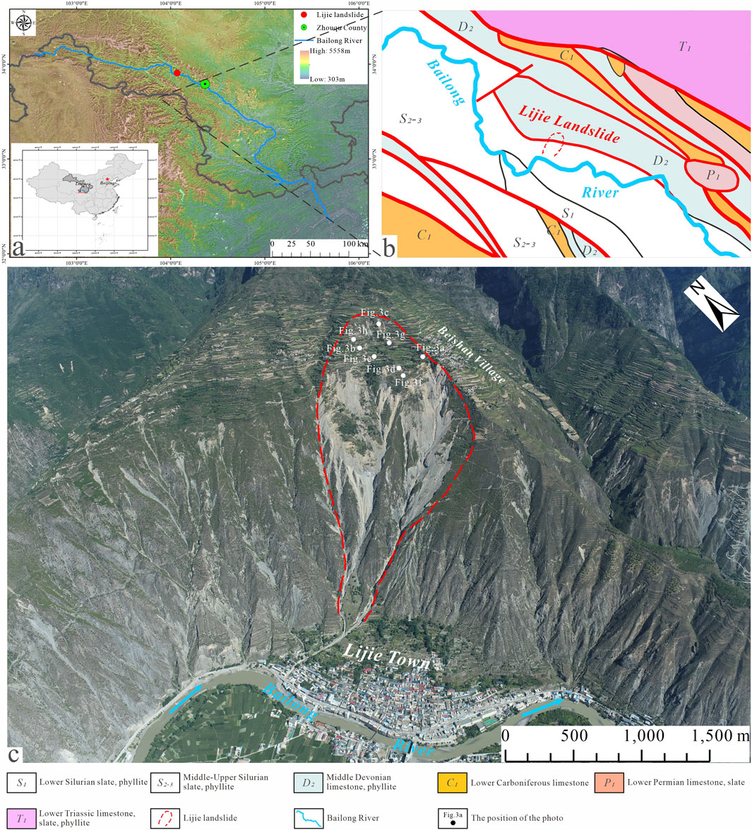
Figure 1. Location and overview maps of the Lijie landslide. (a) Location of the Lijie landslide; (b) Geological map of the Lijie landslide area; (c) Overview of the Lijie landslide.
3 Geological characteristics
3.1 Geological setting
The Lijie landslide area is within the Zhouqu-Wudu seismic sub-belt, Bailong River compound dorsal slope, and Bailong rift zone influence area; moreover, the area is also one of the strongest zones of new tectonic movement, owing to nearby steep mountains, river valley development, broken slope rocks and soil body structures, small folds, and secondary rupture development. The overall topography of the landslide area is high in the north and low in the south, with substantial topographic relief; this topography can be divided into two geomorphological types according to the cause of the formation and morphological characteristics: tectonic erosion mountainous landforms and erosion and accumulation of river valley landforms (Figure 1c). The mountain is open to the south side of the “V” -shape with an irregularly spreading arc; the slope profile has a steep up and down shape, with less steepness in the middle, and the bottom is flat. In the landslide area, an anticlinal fracture passes through the slope where the Lijie landslide body is located, and its direction is nearly perpendicular to that of the Lijie landslide (Figure 2). The fracture belongs to the northern branch of the Bailong River fracture zone within the northern edge of the GDF, dividing the stratum and controlling and influencing the direction of the mountain. This dynamic ensures that the mountain body facilitates the development of fault blocks, destruction of strong rocks, and formation of a typical tectonic damage zone. Affected by fracture activity, the rock and soil bodies in the landslide area are broken and loose, and the subsequent collapse and rockfall develop on both sides of the back edge of the high and steep mountains. Numerous collapsed blocks of rocks and stones are accumulated on the middle and upper parts of the gentle landslide (Figure 3c).
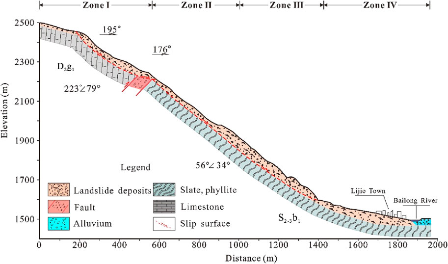
Figure 2. Geological A-A′ cross-section.
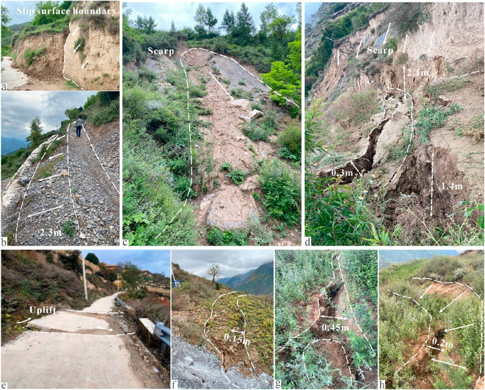
Figure 3. Deformation of cracks based on field investigation. (a) Slip surface boundary; (b,e) Deformation of roads in the landslide; (c) Collapse; (d,f–h) Deformation of cracks.
According to meteorological data, the multi-year average rainfall in the landslide area and its surrounding regions was 475 mm, the maximum daily rainfall was 63.3 mm, and the maximum hourly rainfall was 47.0 mm. Over the past 5 years, the annual precipitation in the study area has demonstrated a yearly increasing tendency. Precipitation within the area is concentrated from June to September and mostly occurs as heavy and concentrated rainfall (Figure 4).
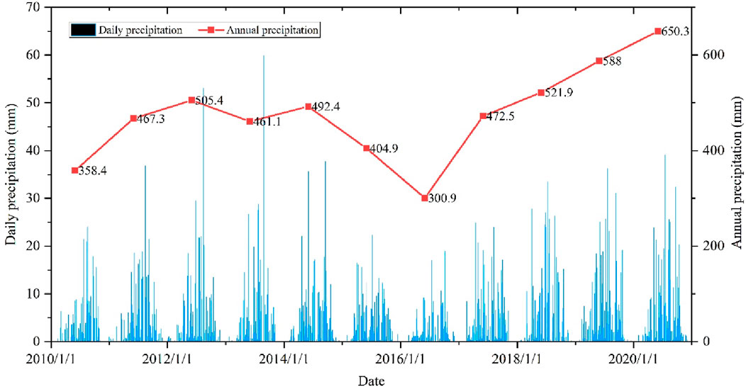
Figure 4. Multi-year data on rainfall in the study area. (2010/1/1–2020/12/31)
3.2 Lithology
According to field investigations and drilling, the strata in the landslide area, from old to new, are middle and upper Silurian (S2+3bl1) slate and phyllite, middle Devonian (D2g) limestone, upper Pleistocene Malan loess, and Quaternary (Q4) Holocene loose accumulations of deposits. The slate and phyllite, predominantly distributed in the middle-lower section of the landslide, exhibit thin-bedded structures with a bedding attitude of 23° ∠ 24°. These rocks exhibit alternating soft and hard layers with heterogeneous mechanical properties. Notably, phyllite layers are prone to water-induced softening and argillization, showing a substantial reduction in wet compressive strength, accompanied by well-developed weathered layers (Figure 5a). Limestone, mainly located in the upper landslide body with a steep bedding attitude of 223° ∠ 79°, features intensive joint development and prominent karst phenomena. Characteristic solution channels were frequently observed in limestone blocks. Although the upper limestone presents medium-thick beds, long-term karstification, tectonic compression, and gravitational stress-induced noticeable toppling deformation features (Figure 5b), the Malan loess is mainly distributed in the upper part of the landslide near Beishan Village, displaying a yellowish-brown coloration and loose structure dominated by silty soils. This unit contains vertical fractures and abundant root systems, covering approximately 1 km2 with an average thickness of 13.1 m (Figure 5c). The shallow superficial layer of the Quaternary System has the characteristic of rock formation 223° ∠ 79°; Quaternary deposits consist primarily of secondary loess, landslide-derived brecciated soils, and residual-slope deposits. These materials are predominantly composed of angular gravel and rubble with silty clay infill and exhibit high porosity, strong permeability, and low to medium compressibility. Widely distributed throughout the area, these deposits constitute the main components of the sliding mass (Figures 5d,e). Notably, a thrust fault zone is located between the Middle Devonian Guodaoling Formation (D2g) limestone and the Middle-Upper Silurian Bailongjiang Group (S2+3bl) slate. This approximately 100 m-wide fault zone dips southward and contains brecciated materials primarily derived from the original Silurian slate bedrock (Figure 2). The fault zone materials consist mainly of crushed stone soils, reflecting intense tectonic deformation.
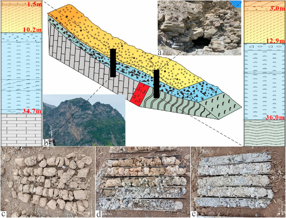
Figure 5. The material composition from drilling of the Lijie landslide. (a) Silurian slate, phyllite. (b) Devonian limestone. (c) Shallow portion of the landslide consisting of fill, loess, and a silty clay layer, as revealed in ZK05; the depth ranges from 0 to 12.9 m. (d,e) Middle and deep portions of the landslide, respectively, demonstrating a gravelly soil layer, as revealed in ZK19, with a thickness of 20–26 m.
3.3 Internal structure
To gain insights into the stratigraphic architecture, sliding mass thickness, depth of the sliding surface, and geological framework of the landslide, an integrated approach employing drilling engineering and the opposing-coils transient electromagnetic (OCTEM) method was adopted to investigate the internal configuration of the landslide body. This comprehensive exploration revealed pivotal characteristics, including the landslide’s constituent materials, thicknesses of various strata, and fault structures. Within the landslide body, four exploration lines utilizing the OCTEM method were established (Figure 6), with WT4 representing a cross-sectional profile and the remaining lines representing longitudinal profiles.
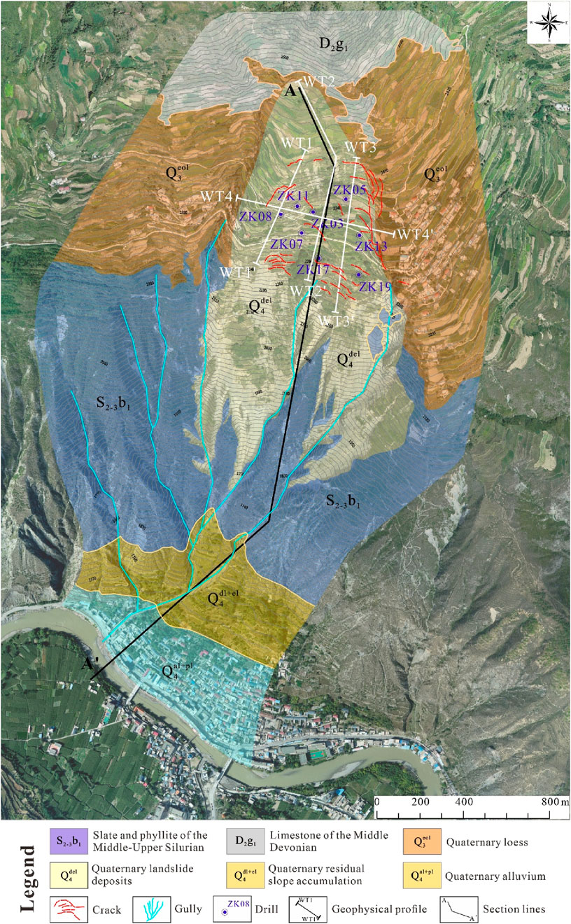
Figure 6. Distribution and topographical map of the Lijie landslide.
Based on the apparent resistivity anomalies resulting from the disparities in resistivity among various lithologies, combined with a comparison of the lithology of the boreholes on the same scale, and with reference to the data presented in existing studies (Chong et al., 2023), the landslide body was stratified into four distinct layers within a confined exploration perimeter of 100 m (Figure 7). The first layer, characterized by a low resistivity of less than 200 Ω·m, likely consists of Quaternary silt, loess, gravelly soil, and other soil horizons, spanning a thickness ranging from approximately 3–20 m. The second layer, exhibiting a medium-to-low resistivity, with values ranging from 200 to 300 Ω·m, is likely composed of Quaternary weathered gravelly soil, with a thickness varying between approximately 4 and 15 m. This layer is abundant in gravel, has a loose structure, and is prone to saturation with water. The third layer, positioned centrally and characterized by a medium resistivity of 300–380 Ω·m, is likely a strongly weathered gravel layer derived from parent rocks such as schist, slate, and limestone. This layer has a thickness of roughly 14–40 m, exhibits robust cementation, and is relatively stable. The fourth layer, distinguished by high resistivity, with an apparent resistivity exceeding 380 Ω·m, is likely composed of deep-seated bedrock, including schist, slate, and limestone, and exhibits an exceptional stability.
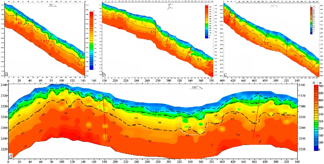
Figure 7. Geophysical profiles. (a) WT1-WT1’. (b). WT2-WT2’. (c). WT3-WT3’. (d). WT4-WT4’. The white dashed circle reveals the fragmentation and incompleteness of the strata.
Moreover, the geophysical exploration results revealed the presence of five fault structures of considerable scale within the Lijie landslide area, encompassing three near-east–west trending faults (F1-F3) and two near-north–south trending faults (F4 and F5). Notably, the F3 fault functions as the primary controlling structure of the landslide, extending in a northwest-southeast orientation and delineating its stratigraphic and topographic boundaries. The remaining faults primarily impact the stratigraphic coherence. Consequently, intense geological tectonic activities have prevailed within the landslide area, resulting in fractured strata that provided favorable conditions for the initiation and progression of landslides.
4 Deformation characteristics
4.1 Field investigation
A detailed field investigation revealed that four collapse disasters occurred within the landslide body, all of which were bedrock collapses (Figure 3c; Table 1). The surface is covered by loess closely concentrated in the rear part of the landslide. The characteristics of the four collapse disasters are similar, belonging to step-like collapses, and their planar shapes are all tongue-shaped. The collapse sources are the bedrock at the rear part of the landslide, and the collapsed materials are all limestone boulders with particle sizes ranging from 2 to 40 cm, which are concentrated in the lower terraces after the collapse. The rock blocks in the collapse source area are highly weathered with crossover and overlapping fracture surfaces, and the surface appears fragmented. Rocks and blocks continue to fall under natural conditions, and their stability is poor. There remains a possibility of spreading backward and on both sides. As the spread range increases, the four collapses merge, forming a large area of deformation and damage. In addition to the collapse failure mode, it forms small-scale hazards such as step-like scarps and local sliding.
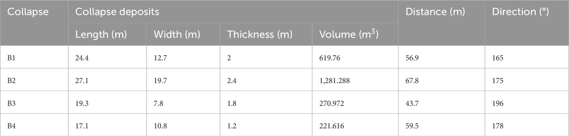
Table 1. Characteristics of collapses.
Cracks in the eastern part of the landslide area have mainly developed along mountain ridges and terraced field banks. All cracks have penetrated throughout. Influenced by farmland cultivation and human engineering activities, multiple small-scale, shallow, and stepped landslides of the staggered type have occurred in the area (Figures 3a, 8c), forming several stepped banks with varying height differences, with an average height difference of approximately 1 m. A ground collapse also occurred at the entrance village road at the front edge, with a collapse area of approximately 37 m2 and collapse depth ranging from 10 to 15 cm. This collapse was mainly triggered by the sliding deformation of the slope on the outside of the road (Figure 8d). An anti-slide pile project exists on the mountain side of the collapse. The lock discs of the two piles at the easternmost end have emerged above the ground and the outer side of the retaining wall is exposed. Based on the measurement of the exposed piles, due to the downward dislocation and collapse of the road, the pile head of the pile (1#) emerges above the ground by 0.34 m (Figure 8a), and the other pile (2#) tilts as a whole. The upper part of the anti-slide pile was tilted by approximately 5° in the direction of the landslide, causing local dislocation and uplift of the adjacent roadbed (Figure 8b). Currently, the cracks within the slope continue to extend and develop, and their widths are continuously increasing, indicating that deformation is ongoing and the block is in an unstable state.
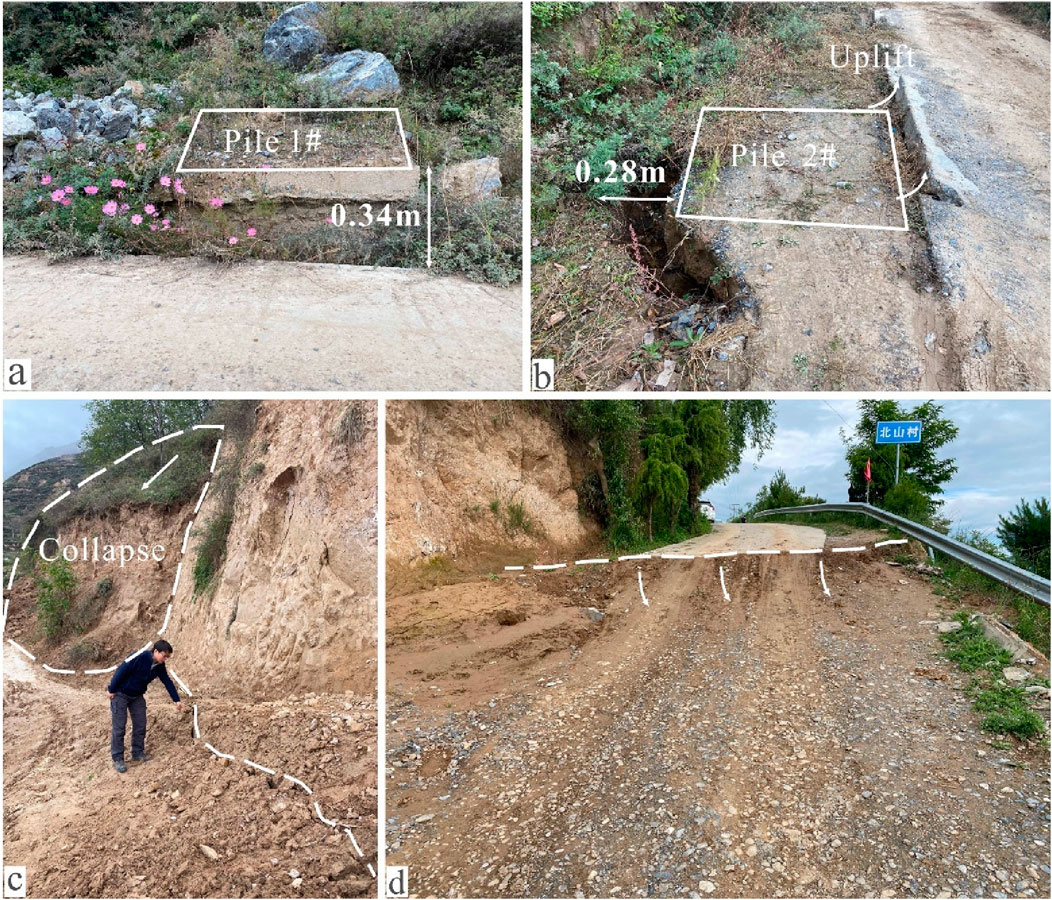
Figure 8. Deformation of cracks in the road area. (a,b) Deformation of piles; (c,d) Deformation of road.
On the east and west sides, multiple cracks developed beneath the existing lattice frameworks. The cracks were distributed along the east-west direction on the plane, presenting an arc shape and tensile cracks. At the bottom corners of the lattice frameworks, the shallow landslide accumulation soil and crushed stone soil continuously collapsed, resulting in a continuous increase in the exposed front face and a reverse expansion characteristic of the deformation zone. There are indications of damage and exposure at the bottom of the lattice framework (Figure 9).
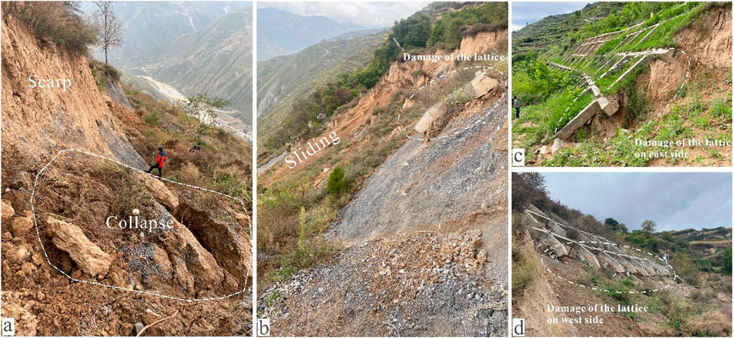
Figure 9. Deformation on the front edge of the landslide. (a,b) Collapses on the front edge of the landslide; (c,d) Damage of the lattices.
Similarly, field investigations showed that nearly 40 tension fractures developed in the landslide source area, and their plane morphology was linear or arc-shaped, mostly distributed at the eastern edge and front of the landslide source area (Table 2). The scale and degree of development of the fractures differ, ranging from 10 to 120 m in length, 2–40 cm in width, and 15–30 cm in depth. Local fractures have formed staggered steep canes with a height difference >50 cm, among which the largest deformation drop was 2.1 m (Figure 3d). Most of the fractures strike in the plane along the east-west direction, but the fracture strikes at the two sides of the boundary are near north-south. At present, all the cracks have penetrated and continue to extend, indicating that the landslide is undergoing continuous deformation.
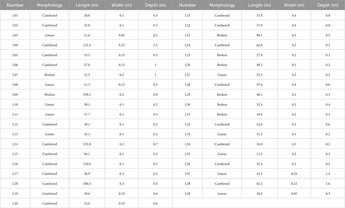
Table 2. Characteristics of cracks.
Owing to the special topographic characteristics of the Lijie Beishan landslide, which is “flat on the top and steep at the bottom,” the shallow accumulation body at the leading edge of the landslide slips and slides more intensely, the slip surface is shallow, and the loose accumulation body in the east and west side of the trench provides more material sources. The source area of the slide body did not slide as a whole, but the signs of deformation are obvious; as the performance of the back wall and the leading edge of the local collapse slipped, internal road faulting, crack development, and other phenomena, in space, occurred on the east side, at the leading edge of the large deformation; on the west side of the deformation, these characteristics occurred near the relatively small edge.
4.2 Subsurface deformation characteristics
Four boreholes were selected as monitoring points to conduct deep displacement monitoring and reveal the location of the sliding surface and deep deformation conditions. Observation points CX1 to CX4 were designated ZK05, ZK11, ZK17, and ZK19, respectively; their locations are shown in Figure 6. Owing to the ongoing creep deformation of the landslide, we inferred from continuous 4-day deep displacement monitoring (15 to 18 March 2020) that the sliding surface was located at a depth of 21–24 m, approximately at the contact surface between the second and third layers of gravel soil (Figure 5).
The CX1 monitoring curve (Figure 10a) shows that the depth of the sliding surface in the middle and rear parts on the eastern side of the sliding source area was approximately 21 m. From 15 to 18 March 2020, the cumulative horizontal displacement at the upper part of the sliding surface was 15 mm, with a deformation rate of 3.75 mm/day. The CX2 monitoring curve (Figure 10b) in the middle and rear parts of the western side of the sliding source area indicates that the sliding surface was located at a depth of 12–14 m. The cumulative horizontal displacement and deformation rate within 4 days were approximately 12 mm and 3 mm/day, respectively. The CX3 and CX4 monitoring curves (Figures 10c,d) reveal that the depth of the sliding surface at the front edge of the sliding source area was approximately 23–24 m. The cumulative horizontal displacements at the upper part of the sliding surface from March 15 to 18, 2020, for the central CX3 and eastern CX4 of the front edge of the source area were 8.4 and 22 mm, respectively, with deformation rates of approximately 2.1 and 5.5 mm/day, respectively.
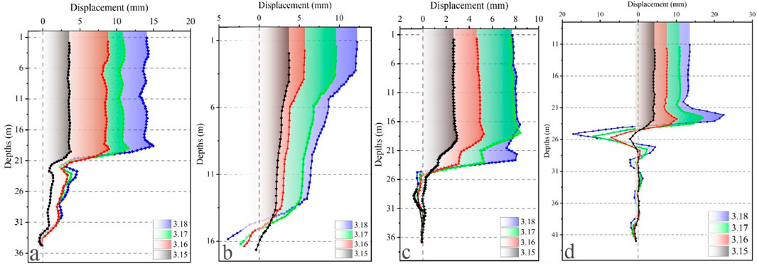
Figure 10. Monitoring curves of deep displacement. (a) CX1 monitoring curve. (b) CX2 monitoring curve. (c) CX3 monitoring curve. (d) CX4 monitoring curve.
Overall, the results of deep displacement monitoring indicate that the deformation direction at the sliding surface is between 179° and 195° (Table 3), which is consistent with the main sliding direction of the landslide and conforms to the deformation characteristics reflected by field investigations, drilling, and geophysical exploration.
Table 3. Monitoring results of deep displacement from March 15 to 18, 2020.
4.3 Initiation mechanism
The Lijie Beishan landslide can generally be categorized as a high-elevation shear-out landslide dominantly controlled by a fault zone. Based on its structural configuration and deformation evolution, this landslide system can be compartmentalized into four functional domains: (I) a source detachment zone, (II) dynamic loading-erosion zone, (III) transformation zone, and (IV) transport-deposition zone. A critical fault zone traversing the upper-middle slope governs deformation initiation and failure propagation mechanisms. Progressive instability within the source detachment zone triggers shear failure along the upper-middle slope segments. This mobilized mass dynamically impacts and loads mid-slope colluvial deposits through erosive-plowing mechanisms. The resultant downslope movement entrains surface materials, potentially inducing multiblock destabilization and catastrophic amplification through mass-coupling effects. Topographic confinement facilitates the phase transition from slope-confined debris movement to channelized debris flows. Subsequent rainfall interactions promote flow transformation and downstream propagation, ultimately forming slope-foot depositional lobes. The proximal relationship between the deposition zones and the Bailong River creates a high potential for channel blockage and subsequent barrier lake formation, thereby establishing a cascading hazard chain (Figure 11).
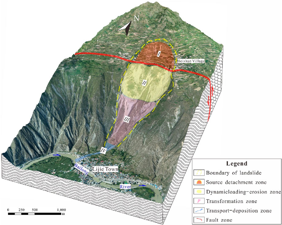
Figure 11. 3D geological model of the Lijie landslide.
From a geomechanical perspective, tectonic compression has generated an upper slope reverse fault oriented perpendicular to the slope direction, producing localized surface uplift and platform formation. Multiple historical slope failures have deposited substantial amounts of colluvial materials on this platform, which have undergone progressive pedogenesis into gravelly soils and deposits under weathering regimes. Seismic triggers or anthropogenic disturbances have progressively weakened these deposits, forming metastable blocks. Concurrently, mid-slope terrain effects induce progressive face development through localized collapses, reducing overall slope stability and accelerating shear zone coalescence. The slope exhibits adverse structural geometry with bedding orientation opposing slope direction, predisposing it to flexural toppling. Hydrologically, the upper karstified limestone aquifer (with high permeability) overlies the relatively impermeable fault breccia and Silurian metasediments, creating a perched groundwater system. Meteoric infiltration and limestone-derived groundwater converge within the fault zone, reducing its strength through pore pressure elevation and weathering. This hydromechanical coupling promotes elastoplastic/elastic-brittle failure modes within the critical fault zone, ultimately triggering large-scale mobilization of slope deposits.
5 Discussion
Complex energy transmission and conversion often occur during the formation and evolution of high-level geological disasters. Extensive research has demonstrated that these disasters exhibit important chain-reaction characteristics and possess strong disaster-causing potential (Yin et al., 2021; Chong et al., 2023). This series of multi-hazard chain effects poses substantial geological safety risks. Through comprehensive analyses of the Lijie landslide, we conclude that this landslide has the potential to evolve into a landslide-debris flow disaster chain. During its progression, the landslide will experience three critical stages: high-elevation initiation, dynamic loading and erosion, and debris flow to mudslide transformations. Based on these findings, we proposed a chain disaster evolution model for the Lijie landslide (Figure 12).
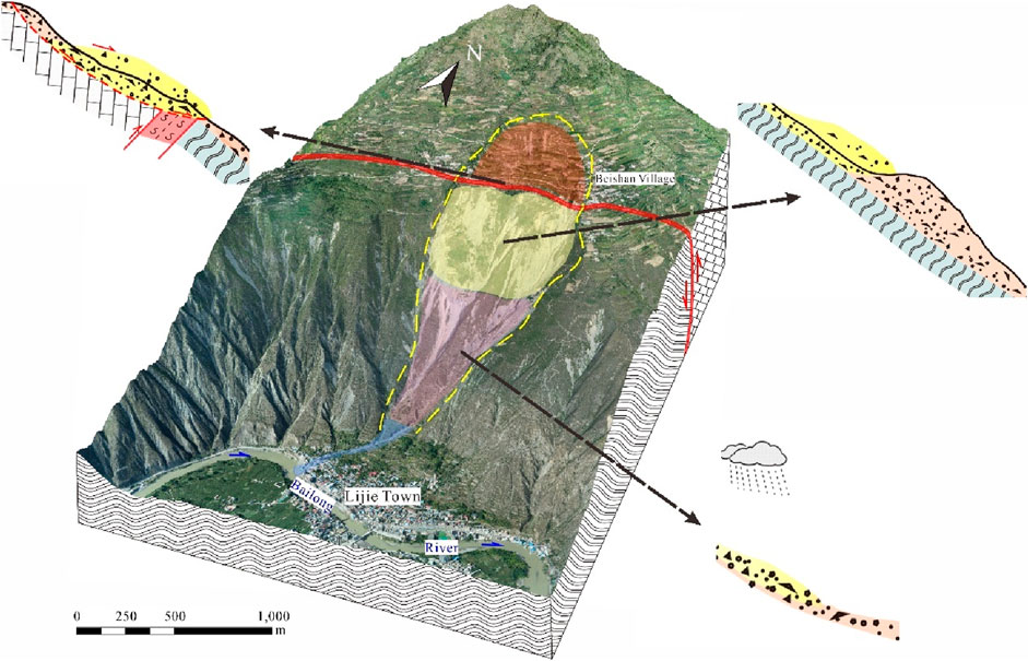
Figure 12. Evolution process of the Lijie landslide.
Notably, within the Bailong River Basin, high-elevation and long-run geological disasters with complex formation mechanisms and chain reaction characteristics, similar to the Lijie landslide, were relatively prevalent. Because the area was a strong uplift area in the Cenozoic era and near the center of the Bailongjiang active fracture zone, there were frequent geological and tectonic activities in the area. Influenced by tectonic movement during the middle - upper Pleistocene period, the region experienced large-scale landslides and the formation of ancient landslides many times. The slide bed of the ancient landslide was the original bedrock and the slide body was a gravelly soil layer accumulated by avalanches and slides. Subsequently, along with the strong uplift of the tectonic structure in the area, a thicker Upper Pleistocene wind-deposited loess was deposited on the landslide body. The topography of the loess platform was then formed. Affected by mountain uplift and other effects, deformation and destruction of ancient landslides in the middle and front, and the formation of old landslides, the slide did not entirely leave the slip bed. The slope retained a large number of ancient landslides and old landslides on the slope body of the landslide accumulations; being accompanied by the intensification of human engineering activities, the gradual weakening of the stability of the landslide accumulations owing to factors such as precipitation induced the formation of new landslides triggered by new deformation and sliding. Subsequently, following a series of energy transmission and transformation processes such as dynamic erosion and flow regime transformation, a chain disaster with enhanced destructive power and an extended disaster-causing range is formed.
6 Conclusion
This study investigated the deformation characteristics and initiation mechanisms of the Lijie landslide using comprehensive surveys. The following conclusions were drawn:
1. The Lijie landslide is categorized as a high-elevation shear-out landslide dominantly controlled by a fault zone and is systematically divided into four functional domains: (I) a source detachment zone, (II) dynamic loading-erosion zone, (III) transformation zone, and (IV) transport-deposition zone.
2. The spatial heterogeneity in landslide deformation, governed by the slope-transecting fault zone, was manifested as concentrated deformation features in the eastern source and frontal zones. These features include multiple through-going tensile cracks, road dislocations, and localized collapses along the rear scarps and frontal margins.
3. Hydraulic property disparities between lithologic units endow the fault zone with distinct water-enriched characteristics, progressively weakening geomechanical strength and reducing slope stability. Potential large-scale mass mobilization could initiate a compound geohazard chain, thus substantially amplifying secondary disaster risks.
Data availability statement
The raw data supporting the conclusions of this article will be made available by the authors, without undue reservation.
Author contributions
JG: Writing – original draft, Writing – review and editing. NZ: Writing – original draft, Writing – review and editing. XC: Writing – original draft, Writing – review and editing. LW: Writing – original draft, Writing – review and editing. WW: Writing – original draft, Writing – review and editing. RL: Writing – original draft, Writing – review and editing.
Funding
The author(s) declare that financial support was received for the research and/or publication of this article. The work was supported by funding from Sichuan Science and Technology Support Project (N5100012024000900); Geological Survey Project of the China Geological Survey (DD20230446); the project Risk Assessment and Comprehensive Prevention and Control of Major Geological Disasters in Zhouqu, Gansu.
Acknowledgments
We gratefully acknowledge support from the Gansu Institute of Geo-Environment Monitoring. The editor and the two reviewers provided further constructive comments.
Conflict of interest
The authors declare that the research was conducted in the absence of any commercial or financial relationships that could be construed as a potential conflict of interest.
Generative AI statement
The author(s) declare that no Generative AI was used in the creation of this manuscript.
Publisher’s note
All claims expressed in this article are solely those of the authors and do not necessarily represent those of their affiliated organizations, or those of the publisher, the editors and the reviewers. Any product that may be evaluated in this article, or claim that may be made by its manufacturer, is not guaranteed or endorsed by the publisher.
References
Chen, G., Jin, J., Meng, X., Qi, T., Shi, W., Chong, Y., et al. (2024). Influence of tectonic effects on the formation and characteristics of landslide dams on the NE Tibetan Plateau: a case study in the Bailong River Basin, China. Landslides 21, 2135–2153. doi:10.1007/s10346-024-02273-1
Chong, Y., Chen, G., Meng, X., Bian, S., Huang, F., Lin, L., et al. (2023). Formation mechanism and quantitative risk analysis of the landslide-induced hazard chain by an integrated approach for emergency management: a case study in the Bailong River basin, China. CATENA 233, 107522. doi:10.1016/j.catena.2023.107522
Dong, J., Liao, M., Xu, Q., Zhang, L., Tang, M., and Gong, J. (2018). Detection and displacement characterization of landslides using multi-temporal satellite SAR interferometry: a case study of Danba County in the Dadu River Basin. Eng. Geol. 240, 95–109. doi:10.1016/j.enggeo.2018.04.015
Eaves, S. R., McColl, S. T., Tielidze, L. G., Norton, K. P., Hopkins, J. L., and Hidy, A. J. (2023). The age and potential causes of the giant Green Lake Landslide, Fiordland, New Zealand. Landslides 20, 1883–1892. doi:10.1007/s10346-023-02075-x
Fan, X., Xu, Q., Scaringi, G., Zheng, G., Huang, R., Dai, L., et al. (2019). The “long” runout rock avalanche in Pusa, China, on August 28, 2017: a preliminary report. Landslides 16, 139–154. doi:10.1007/s10346-018-1084-z
Gao, Y., Li, B., Gao, H., Chen, L., and Wang, Y. (2020). Dynamic characteristics of high-elevation and long-runout landslides in the Emeishan basalt area: a case study of the Shuicheng “7.23”landslide in Guizhou, China. Landslides 17, 1663–1677. doi:10.1007/s10346-020-01377-8
Gao, Y., Yin, Y., Li, B., Feng, Z., Wang, W., Zhang, N., et al. (2017). Characteristics and numerical runout modeling of the heavy rainfall-induced catastrophic landslide–debris flow at Sanxicun, Dujiangyan, China, following the Wenchuan Ms 8.0 earthquake. Landslides 14, 1361–1374. doi:10.1007/s10346-016-0793-4
Guo, C., Zhang, Y., Li, X., Ren, S., Yang, Z., Wu, R., et al. (2020). Reactivation of giant Jiangdingya ancient landslide in Zhouqu county, Gansu Province, China. Landslides 17, 179–190. doi:10.1007/s10346-019-01266-9
He, Q., Guo, F., Li, R., Wang, L., Wang, W., Zhang, N., et al. (2023). Characteristics, mobility and dynamic of the Yahuokou flow-like landslide in Zhouqu, Gansu, China. Landslides 20, 629–643. doi:10.1007/s10346-022-02000-8
Jiang, X., and Wen, B. (2014). “Creep behavior of the slip zone of a giant slow-moving landslide in northwest China: the Suoertou landslide as an example,” in Landslide science for a safer geoenvironment. Editors K. Sassa, P. Canuti, and Y. Yin (Cham: Springer International Publishing), 141–145.
Korup, O., Clague, J. J., Hermanns, R. L., Hewitt, K., Strom, A. L., and Weidinger, J. T. (2007). Giant landslides, topography, and erosion. Earth Planet. Sci. Lett. 261, 578–589. doi:10.1016/j.epsl.2007.07.025
Liu, W., Zhang, Y., Meng, X., Wang, A., Li, Y., Su, X., et al. (2024). Forecast volume of potential landslides in alpine-canyon terrain using time-series InSAR technology: a case study in the Bailong River basin, China. Landslides 21, 35–51. doi:10.1007/s10346-023-02135-2
Pánek, T., Schönfeldt, E., Winocur, D., Břežný, M., Šilhán, K., Chalupa, V., et al. (2020). Moraines and marls: giant landslides of the lago pueyrredón valley in patagonia, Argentina. Quat. Sci. Rev. 248, 106598. doi:10.1016/j.quascirev.2020.106598
Peng, J., Ma, R., Lu, Q., Li, X., and Shao, T. (2004). Geological hazards effects of uplift of Qinghai-Tibet Plateau. Adv. Earth Sci., 19 (3), 457–466. (in Chinese with English abstract).
Shilin, Z., Yin, Y., Hu, X., Wang, W., and He, X. (2023). Block-grain phase transition in rock avalanches: insights from large-scale experiments. J. Geophys. Res. Earth Surf. 128. doi:10.1029/2023JF007204
Strom, A. L., Korup, O., Abdrakhmatov, K. E., and Havenith, H.-B. (2005). “Investigating rock-slope failures in the tien Shan: state-of-the-art and perspectives of international cooperation (M111),” in Landslides: risk analysis and sustainable disaster management. Editors K. Sassa, H. Fukuoka, F. Wang, and G. Wang (Berlin, Heidelberg: Springer Berlin Heidelberg), 109–112. doi:10.1007/3-540-28680-2_12
Sun, Q., Zhang, L., Ding, X. L., Hu, J., Li, Z. W., and Zhu, J. J. (2015). Slope deformation prior to Zhouqu, China landslide from InSAR time series analysis. Remote Sens. Environ. 156, 45–57. doi:10.1016/j.rse.2014.09.029
Wasowski, J., and Bovenga, F. (2014). Investigating landslides and unstable slopes with satellite Multi Temporal Interferometry: current issues and future perspectives. Eng. Geol. 174, 103–138. doi:10.1016/j.enggeo.2014.03.003
Yang, L., Zhang, M., Wang, L., Liu, T., Shi, P., Yin, B., et al. (2024). Failure kinematics and mechanisms of the 2019 Yahuokou flow-like landslide along the Pingding-Huama fault in Zhouqu segment. Eng. Geol. 332, 107448. doi:10.1016/j.enggeo.2024.107448
Yang, X., Jiang, Y., Zhu, J., Ding, B., and Zhang, W. (2023). Deformation characteristics and failure mechanism of the Moli landslide in guoye Town, Zhouqu county. Landslides 20, 789–800. doi:10.1007/s10346-022-02019-x
Yin, B., Yin, Y., Zhang, M., Zhang, C., He, Q., and Wang, G. (2024). Active fault control led to the Moli landslide triggered by rainfall on 26 February 2021 in Zhouqu County, Gansu, China. Landslides 21, 83–98. doi:10.1007/s10346-023-02175-8
Yin, Y., Li, B., Yang, G., Wang, W., Shilin, Z., Zhang, N., et al. (2022). Characteristics and dynamic analysis of the February 2021 long-runout disaster chain triggered by massive rock and ice avalanche at Chamoli, Indian Himalaya. J. Rock Mech. Geotechnical Eng. 15, 296–308. doi:10.1016/j.jrmge.2022.04.003
Yin, Y., Zhu, S., and Li, B. (2021). High-level remote geological disasters in Qinghai-Tibet Plateau. Beijing: Science Press. (in Chinese).
Zhang, Y., Meng, X., Jordan, C., Novellino, A., Dijkstra, T., and Chen, G. (2018). Investigating slow-moving landslides in the Zhouqu region of China using InSAR time series. Landslides 15, 1299–1315. doi:10.1007/s10346-018-0954-8
Zhang, S., Yin, Y., Hu, X., Wang, W., Zhu, S., Zhang, N., et al. (2020). Initiation mechanism of the Baige landslide on the upper reaches of the Jinsha River, China. Landslides 17, 2865–2877. doi:10.1007/s10346-020-01495-3
Zhang, Y., Zhang, Y., Wu, H., Li, C., Aspe, N. M., and Wu, D. (2022). Patterns of genetic variation in the Eisenia nordenskioldi complex (Oligochaeta: lumbricidae) along an elevation gradient in northern China. Diversity 14, 35. doi:10.3390/d14010035
Keywords: landslide hazards, tectonic control, deformation characteristics, initiation mechanism, Bailong river basin
Citation: Gao J, Zhang N, Cui X, Wang L, Wang W and Li R (2025) Deformation characteristics and initiation mechanism of the Lijie landslide, Zhouqu, China. Front. Earth Sci. 13:1603042. doi: 10.3389/feart.2025.1603042
Received: 31 March 2025; Accepted: 21 April 2025;
Published: 17 June 2025.
Edited by:
Shilin Zhang, Southwest Jiaotong University, ChinaReviewed by:
Kun He, Southwest Jiaotong University, ChinaLongwei Yang, China Coal Technology Engineering Group, China
Copyright © 2025 Gao, Zhang, Cui, Wang, Wang and Li. This is an open-access article distributed under the terms of the Creative Commons Attribution License (CC BY). The use, distribution or reproduction in other forums is permitted, provided the original author(s) and the copyright owner(s) are credited and that the original publication in this journal is cited, in accordance with accepted academic practice. No use, distribution or reproduction is permitted which does not comply with these terms.
*Correspondence: Nan Zhang, NTE0OTc5MzQxQHFxLmNvbQ==