 Kiera L. O’Donnell
 Tori Tomiczek
 Steven B. Scyphers
- 1Department of Marine and Environmental Sciences, Northeastern University, Nahant, MA, United States
- 2Department of Naval Architecture and Ocean Engineering, United States Naval Academy, Annapolis, MD, United States
- 3Department of Marine and Environmental Sciences, Coastal Sustainability Institute, Northeastern University, Nahant, MA, United States
- 4Social Science Environmental Health Research Institute, Northeastern University, Boston, MA, United States
Hurricanes have large and lasting effects along coastlines, representing one of the deadliest and costliest natural hazards. Among the rapidly growing literature on the impacts of hurricanes, an increasing topic of interest is the potential role of mangroves, and other coastal habitats, as nature-based strategies (NBS) for coastal defense. In addition to coastal protection, NBS have been shown to provide many ecological, economic, and social co-benefits. However, few studies have assessed coastal resident perceptions or residential-scale performance of NBS, particularly in the wake of major hurricanes. Through a survey of 288 residents of the Lower Florida Keys 1 year after Hurricane Irma, this paper describes hurricane impacts on mangroves, beaches, and hardened shorelines. Specifically, we measured perceptions of shoreline damage and shoreline effectiveness for coastal protection at the community- and parcel-levels. At the parcel scale, we also measured performance outcomes through the cost to repair or replace residential shorelines. At both community- and parcel-levels, beaches were perceived as the most damaged shoreline type, followed by mangroves, and then hardened shorelines as the least damaged. Specifically at the parcel-level, repair actions were not taken by many residents with a hardened shoreline (43.2%) due to their shoreline receiving no damage. However, when repair actions were taken, the average cost to repair or replace parcel-level mangroves ($64.33 (USD)
Introduction
With sea level rising, ocean warming, and coastal populations increasing, natural hazards increasingly impact both the biophysical landscape, and human communities situated near shorelines (O’Keefe et al., 1976; Emanuel 2005; Donnelly and Woodruff, 2007; Pielke et al., 2008). Historically, many landowners and other important actors have armored coastlines with hardened infrastructure to counteract coastal hazards, such as erosion, flooding, and storms (National Research Council, 2007; Gittman et al., 2015; Scyphers et al., 2015). Hardened infrastructure, such as seawalls and riprap revetments, protect against erosion but degrade the natural environment (Bilkovic et al., 2016; Gittman et al., 2016). Recently, there has been a rapidly growing interest in nature-based strategies (NBS) for coastal protection since these strategies provide co-benefits for ecosystems and human communities (Scyphers et al., 2011; Spalding et al., 2014; Arkema et al., 2017; Gittman and Scyphers 2017).
Previous studies have found that implementing NBS can buffer coastal areas during storms due to their wave attenuating properties, increased flood storage capacity, and ability to retain sediment (Quartel et al., 2007; Mcivor et al., 2012; Hashim and Catherine 2013; Guannel et al., 2016; Munoz et al., 2018). For instance, previous studies covering the impacts caused by Hurricane Irma show that in residential areas of high inundation, homes with mangrove shorelines experienced less damage than homes with bulkheads, and beaches (Tomiczek et al., 2020). Mangroves provide coastal communities with storm protective properties due to their complex and dense network of roots (Davis and Fitzgerald, 2008). Additionally, NBS provides many ecosystem services, including carbon storage, aesthetics, and juvenile fish habitats (Lane et al., 2005). Recent studies have also highlighted the important connection between a person’s surrounding environment and their psychological well-being (Collins et al., 2020). Using Hurricane Irma as a case study, this paper describes residents’ perceptions and parcel-scale performance outcomes of shorelines after a major hurricane.
Hurricane Irma made landfall in Cudjoe Key on the morning of September 10, 2017, as a Category 4 storm on the Saffir-Simpson Hurricane Wind Scale (National Oceanic and Atmospheric Administration (NOAA) 2017). Hurricane Irma was a large storm with maximum sustained wind fields of 58 m/s (130 mph) extending up to 128 km (80 miles) from the eye at its time of landfall in the Florida Keys. The inundation seen throughout the Lower Florida Keys ranged from 1.5 to 2.4 m (5–8 ft) above ground. Hurricane Irma was ranked as the 5th costliest storm to make landfall in the United States as of 2021, with economic damages estimated at $52.5 billion (USD) (NOAA National Centers for Environmental Information, 2021). The Florida Keys were closed to tourism for approximately 3 weeks, and some areas experienced localized power outages for months. Clean-up of debris from Hurricane Irma was incomplete for nearly 1.5 years after landfall (NOAA 2018). All these day-to-day impacts disrupted residents both economically and psychologically (Lane et al., 2005; Lane et al., 2013; Mamirkulova et al., 2020; Abbas et al., 2021).
Promoting the resilience of coastal communities exposed to intense hazards like hurricanes requires an understanding of the interactions among local biophysical, social, and economic landscapes (Collins et al., 2011). Therefore, coastal planners and scientists must consider the perceptions and decisions made by local residents to have resilient and sustainable systems. This paper describes coastal homeowner perceptions of post-storm impacts to better understand damages to shorelines and the role different types of shorelines play in coastal storm protection. This case study surveys residents along mangroves, beaches, and hardened shorelines in the Lower Florida Keys, who are facing sea level rise, and intense hurricanes along with a growing population and a large tourism industry.
Materials and Methods
Our study assessed the impacts of a major hurricane in the Lower Florida Keys through the lens of 288 residents. A parcel-scale survey was used to better understand how residents in the Lower Florida Keys valued their coastal environments (mangroves, beaches, and hardened structures) in the wake of a hurricane.
The people of the Lower Florida Keys are on the forefront of global climate change and hazards. Hurricanes are a normal occurrence in the Lower Florida Keys and many residents know and understand hurricanes because of this (Radabaugh et al., 2019). Since 1852, 60 tropical storms have passed through a 50-mile radius of the Lower Florida Keys, 12 of which have been a major hurricane (category 3 or higher) (Historical Hurricane Tracks, 2021). Previous studies designated the Florida Keys with elevated risks of sea level rise, flooding, and hurricanes (Emrich and Cutter 2011). The Lower Florida Keys are about 177.5 km2, with 1,531.6 km of shorelines comprised of 63% mangroves, 1% beaches, and 12% hardened structures. However, when limited to the residential areas of the Lower Florida Keys, 78% of residential parcels are along hardened structures, 2% are along beaches, and 15% are along mangroves. Although there are many mangrove forests and mangrove islands throughout the Lower Florida Keys, most residential properties have hardened shorelines. There are concentrated areas of residential properties from Big Pine Key to Big Coppitt Key, most of which are along canals and along the coast. Out of the 8,614 non-vacant residential parcels 74.3% were waterfront.
Survey Design
A 76-question survey instrument was developed using knowledge from previous engineering, sociological, and environmental studies of disasters (Adger et al., 2016; Scyphers et al., 2019; Tomiczek et al., 2020). Drawing from recent engineering studies of recording hurricane damage to shorelines, a key series of questions in our survey measured shoreline damage in two parts (Tomiczek et al., 2020). First, residents were asked about shorelines near where they live (community-level shorelines), then waterfront residents were asked about the shorelines they own (parcel-level shorelines) (Table 1). The types of community-level shorelines were bulkheads (or seawalls), riprap (rocks or coral rock) revetments, beaches, and mangroves. Parcel-level shoreline types were classified into mangrove, hardened, and hybrid (Supplementary Table S1). Homes with a hardened shoreline type were associated with residents who reported owning a bulkhead/seawall or riprap. Mangrove shoreline types were shorelines with only mangrove forests (of any size). Hybrid shoreline types were shorelines with both hardened structures and mangroves. Beaches were uncommon along waterfront residences. The survey included a picture of each shoreline type as a reference aid. The survey provided space for residents to describe and report on both community- and parcel-level shorelines not listed within the survey. Respondents reported all shoreline damage using a 5-point Likert scale (No Damage, Lightly Damaged, Moderately Damaged, Majorly Damaged, and Ruined) (Tomiczek et al., 2020). Respondents also reported the effectiveness of each shoreline type at protecting coastal properties from storms using a 5-point Likert scale (Extremely Effective, Very Effective, Moderately Effective, Slightly Effective, and Not Effective at All). Waterfront respondents then reported how much their parcel-level shoreline cost to maintain per year and to repair or replace their shoreline after the storm. Finally, residents reported on the primary cause of damages to community- and parcel-level shorelines (Storm surge, Winds, and both). We excluded blank responses for monetary questions from calculations and tests. Many residents were still waiting to receive compensation for their insurance claims, had not yet finished repairing their property, or did not want to report on monetary outcomes.
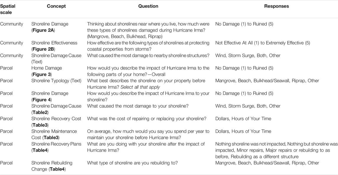
TABLE 1. Survey questions used for measuring impacts of Hurricane Irma. The corresponding figure or table showing the results of the survey questions are in bold.
The survey instrument also measured overall home damage using a 5-point Likert scale (No Damage, Lightly Damaged, Moderately Damaged, Majorly Damaged, and Ruined) which is used to test the ability of shorelines to buffer storm impacts. Housing characteristics were collected based on engineering assessments (elevated, number of stories, and building material) and vulnerability assessments (housing ownership, housing type, and primary residence) (Tomiczek et al., 2014; Tomiczek et al., 2020). Finally, the survey included questions to document gender, age, annual household income, education, and years lived at current residence.
Survey Data Collection
Approximately 1 year after the storm (June 2018–November 2018) a mixed-mode (online, physical) parcel-scale survey was sent to residents asking about Hurricane Irma impacts in the Lower Florida Keys (Figure 1). A stratified sample of 1,500 residents (1,000 waterfront and 500 non-waterfront) were randomly selected using the publicly available Monroe County tax database (University of Florida’s GeoPlan Center, 2006) and the NOAA Environmental Sensitivity Index (ESI). Similar to the methods described by Dillman et al. (2014), residents received three mailings which provided recipients with both an online and a physical survey option. The survey research firm Qualtrics (Qualtrics, Provo, UT) hosted the online survey, and served as the database for the physical survey. The survey yielded an adjusted response rate of 24%, totaling 288 responses (displayed in Figure 1).
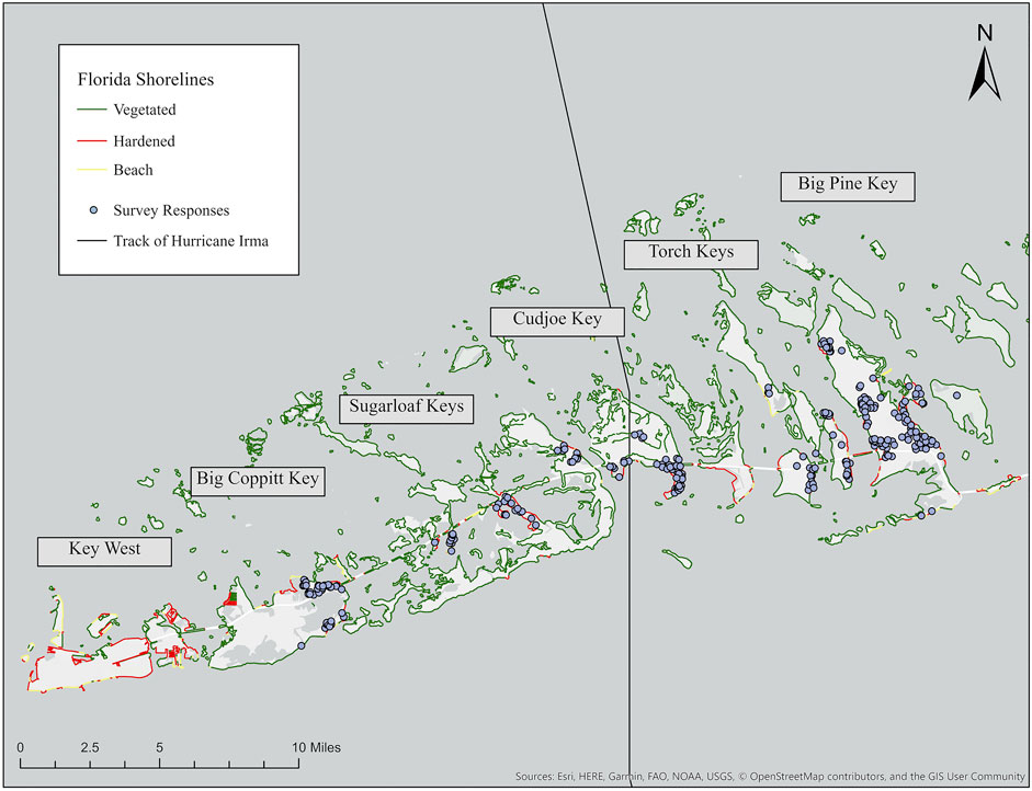
FIGURE 1. Map of Hurricane Irma’s path, shoreline condition, and location of survey respondents throughout the Lower Florida Keys. The map shows the Lower Florida Keys from Key West (not surveyed) on the westernmost side to Big Pine Key on the eastern side of the map. The black line running through Cudjoe Key depicts the track of Hurricane Irma. The NOAA ESI lines reflect the shoreline types based on the following groupings: hardened (seawalls or riprap revetments), vegetated (mangrove, scrub-shrub wetlands, marsh grass, etc.), and beaches. The blue dots represent the survey respondents’ locations.
Analysis
All responses were analyzed in the Statistical Package for Social Science (SPSS) Version 26. Responses were connected to their surrounding environmental characteristics using ArcGIS Pro 2.4.0. Shoreline data from NOAA’s ESI, storm conditions from the Coastal Emergency Risk Assessment (CERA)’s post-storm models, and the island location of residents were linked to each response using unique ID codes. The accuracy of reported location, shoreline type, and length of shoreline were verified using the Monroe County tax database and NOAA’s ESI. Using CERA’s post-storm models, the storm conditions of maximum winds, and maximum inundation were found for each parcel.
We used multivariate, univariate, and descriptive statistics to evaluate the potential cause of shoreline damage and the relationships of shoreline damage to residents’ perceptions and actions (Scyphers et al., 2019). To allow for comparison of shorelines between residents of different parcel sizes, the cost of shoreline maintenance, and the cost of the damage from Hurricane Irma was divided by the length of shoreline owned. Using a Kruskal–Wallis test, we compared shoreline damage and coastal protection effectiveness across the different Keys. Additionally, we compared perceptions of community-level shorelines by the type of shoreline owned. Next, we compared the parcel-level shoreline damage (monetary values per meter of shoreline and reported damage states) by shoreline type. Finally, we compared parcel-level storm characteristics of maximum inundation and maximum winds from Hurricane Irma by the shoreline damage state. When a Kruskal–Wallis test produced a significant result, a Dunn-test was completed to find the categories producing the significant result. We used a Spearman’s rank two-tailed correlation to relate the monetary values of damage with the reported damage states. We also related shoreline damage and coastal protection effectiveness for each shoreline type. All statistical results used an alpha level of 0.05 to indicate significance.
Results
Home Characteristics and Demographics
The proportion of survey respondents from each of the Lower Florida Keys was 14.3% (n = 41) in Big Coppitt Key, 11.9% (n = 32) in Saddlebunch and Sugarloaf Key, 24.1% (n = 69) in Cudjoe Key, 10.8% (n = 31) in the Torch Keys, and 38.8% (n = 111) in Big Pine Key. Of these coastal residents, 70.8% (n = 204) lived in or owned waterfront property (including canals) which aligns with the Lower Florida Keys population. Of these waterfront properties, 74.3% (n = 150) had hardened shorelines, 13.4% (n = 27) owned mangrove shorelines, and 12.4% (n = 25) owned hybrid shorelines.
Participants were primarily white (94%, n = 251) and approximately half were female (51.1%, n = 141). The average age of respondents was 62.8
Perceptions of Community-Level Shoreline Impacts and Effectiveness
On average, community-level shorelines around the Lower Florida Keys (bulkhead/seawall, riprap, beach, and mangrove) were ranked as moderately damaged (Likert scale: 3.17
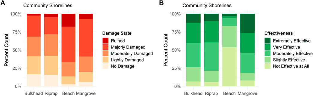
FIGURE 2. Perceptions of community-level shorelines, both the reported damage state (A) and the coastal protection effectiveness (B).
Shoreline coastal protection effectiveness was also significantly different by shoreline type (Kruskal–Wallis test: H = 321.61, df = 3, and p < 0.001; Figure 2B.). Mangroves were ranked the most effective shoreline type at protecting coastal properties from storms, with 54.0% of respondents reporting the protection provided was very to extremely effective. Conversely, beaches were the least effective, with 50% reporting not effective at all. The effectiveness of bulkheads and riprap were not significantly different (Dunn Test: Z = 0.262, p = 0.793). Shoreline coastal protection effectiveness did not vary by key for all shoreline types except Riprap (Kruskal–Wallis tests; Mangrove: H = 7.220, df = 4, and p = 0.125; Beach: H = 5.923, df = 4, and p = 0.205; Bulkhead H = 2.709, df = 4, and p = 0.608; and Riprap H = 12.157, df = 4, and p = 0.016). Respondents in Big Coppitt Key perceived riprap as slightly less effective. For waterfront homeowners, perceptions of community-level shoreline effectiveness were not significantly different for the type of shoreline owned (Kruskal–Wallis tests; Mangrove: H = 2.761, df = 3, and p = 0.430; Beach: H = 3.789, df = 3, and p = 0.285; Bulkhead H = 2.598, df = 3, and p = 0.458; and Riprap H = 0.482, df = 3, and p = 0.923).
Perceptions and Performance of Parcel-Level Shorelines
Most residents reported their home as moderately or lightly damaged, 39.2 and 30.9% respectively. On average, households spent $35,611.06 (USD) (
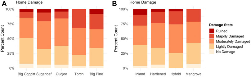
FIGURE 3. Perceptions of home damage states. The colors within each bar reflect the proportion of each reported home damage state. (A) shows the percentage of each reported damage state by key and (B) does the same by shoreline type.
Overall, parcel-level shorelines fared well during the storm, with the plurality of respondents reporting lightly damaged shoreline states (43.1%, n = 82; Figure 4). On average, shoreline repair costs were $4,884.29 (USD) (
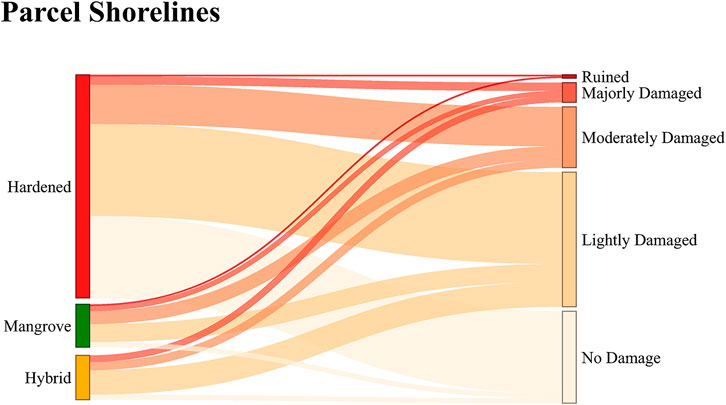
FIGURE 4. Sankey diagram of parcel-level shoreline damage states. Number of responses is proportional to the height of the bars.
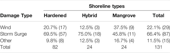
TABLE 2. Percentage of respondents (and number in parentheses) reporting the primary damage type caused by Hurricane Irma displayed across parcel-level shoreline types (Chi-squared test:
Although the primary cause of damage reported was storm surge, damage states of residential shorelines were similar across storm characteristics. Residents across the Lower Florida Keys experienced winds between 49.2–53.6 m/s (110–120 mph). Although winds were similar across parcel-level damage states, ruined shoreline types experienced slightly higher winds (Kruskal–Wallis: H = 8.717, df = 4, and p = 0.069). Residents of the Lower Florida Keys experienced an average inundation of 1.30 m (4.27 ft) and a range of 0.18–2.47 m (0.59–8.10 ft). Inundation was similar across parcel-level shoreline damage (Kruskal–Wallis H = 3.666, df = 4, and p = 0.453). Additionally, the various shoreline types experienced similar levels of inundation (Kruskal–Wallis: H = 5.036, df = 2, and p = 0.081) and winds (Kruskal–Wallis: H = 0.970, df = 2, and p = 0.616) across the study area. However, parcel-level shoreline damage was significantly different by shoreline type (Kruskal–Wallis: H = 13.883, df = 2, and p = 0.001; Figure 4). Many hardened shorelines had low damage states, with 37.0% reporting no damage and 40.7% reporting lightly damaged. Respondents mostly reported mangrove and hybrid shorelines as lightly damaged (42.3 and 55.6% respectively), and few reported these shorelines as no damage (11.5 and 11.1%).
The cost to repair per meter of shoreline was positively correlated with reported shoreline damage states (Spearman’s correlation: R = 0.640, p < 0.001). On average, residents with mangrove shorelines had the longest shoreline property (50.63 m.; Table 3). The maintenance cost per meter of shoreline was similar for both hybrid ($11.90 (USD)

TABLE 3. Reported costs of maintaining and repairing parcel-level shorelines per meter. The first row in the table displays the average parcel-level shoreline length in meters for each category of shoreline type. Next row is the average (
Shoreline recovery actions varied by shoreline type (Chi-squared test:
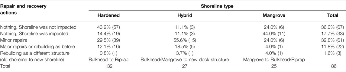
TABLE 4. Repair and recovery actions residents took or will take in response to parcel-level shoreline damage. The table displays the percent of reported actions (and number in parentheses) across the shoreline type owned. The row above the Totals display the planned structures when respondents are rebuilding their shoreline as a different structure.
Discussion
Our study provides insight into the performance and community perceptions of mangroves, beaches, and hardened shorelines in the Lower Florida Keys following Hurricane Irma. A key finding of our study is that storm damage varied across different types of shorelines. Residents reported mangroves had higher damage states than hardened shorelines at both the parcel- and community-levels. However, monetary impacts and reported recovery actions show that mangroves performed well during and after the storm. The per meter cost to repair or replace mangroves was less than hardened shorelines, and fewer repair actions were necessary when damage occurred. Additionally, respondents reported on the effectiveness of mangroves at protecting the coast from storm conditions. Both cost and effectiveness have been ranked highly as attributes homeowners consider when making decisions about their shorelines (Scyphers et al., 2015; Smith et al., 2017). Therefore, our findings could make mangrove systems a valuable shoreline option for coastal homeowners in the Lower Florida Keys. However, the high percent of residents with hardened shorelines, and the strong preference of homeowners to repair or recover their shorelines to its pre-storm condition, indicates that perceptions of mangroves and shoreline actions are not aligning. Therefore, additional incentives may be needed for promoting NBS (Scyphers et al., 2020).
Respondents reported storm surge as the primary cause of damage to parcel- and community-level shorelines. Previous studies on Hurricane Irma, and general post-storm models, show that areas on the eastern side of the storm experienced higher inundation and greater wind speeds (NOAA 2017; Tomiczek et al., 2020), which aligns with the greater damage reported to the east. Interestingly, the bulkhead damage was not different by Key, whereas other shoreline types were most damaged on the eastern-most island of Big Pine Key. The variation in mangrove damage across islands suggest that mangrove shorelines may be more resilient than hardened shorelines at lower inundation values and slower wind speeds (Constance et al., 2021). This is further supported by the high damages to mangroves reported in areas of high inundation and high wind speeds (east of the storm). Conversely, hardened shorelines have similar levels of damage across all Keys, and all storm characteristics.
Although mangroves attenuate waves (Smith et al., 2009; Narayan et al., 2016; Tomiczek et al., 2020), these shorelines allow the water to flow through the roots and may cause more visually apparent damages. Specifically, storm surge can bring sediment and human-made debris into the complex root system of mangroves, sometimes creating delayed mortality of mangrove systems after a storm (Smith et al., 2009; Radabaugh et al., 2019). Hurricane winds can also strip leaves off mangrove trees causing additional visual damage and makes other damages more apparent (Smith et al., 2009). These visible impacts were described throughout several responses and display important influences on residential perceptions of damage states across various shoreline types. However, the monetary costs and reported repair actions of parcel-level mangroves indicate that these visual damages were less costly to remediate.
Previous studies have shown the importance of cost and durability when homeowners make decisions about shoreline protection (Scyphers et al., 2015; Smith et al., 2017). Although mangroves had higher damage states than hardened structures, they also cost less to repair or replace per meter of shoreline (Table 3). This finding could be due to a natural shorelines ability to grow back after a disturbance without human intervention (Radabaugh et al., 2019). Most waterfront residents with mangroves reported that although their shoreline was impacted, no further actions were needed to repair or replace their shoreline, further supporting the ability of mangrove stands to grow back. Conversely, hardened shorelines cost more to repair and replace, and most residents with hardened shorelines reported that if they received damages, minor to major repairs were needed.
Mangroves also cost less to maintain (Table 3), because mangrove shorelines can mature, strengthen, and even expand over time in the right conditions (Spalding et al., 2014; Constance et al., 2021). Whereas hardened structures are rigid and face degradation over time (Sutton-Grier et al., 2018). Previous studies have also shown higher costs for homeowners with hardened structures compared to vegetated shorelines (Gittman and Scyphers 2017; Smith et al., 2017). The economic benefit that natural shorelines provide must be highlighted since cost is important to coastal homeowners (Scyphers et al., 2015; Gittman et al., 2016; Gittman and Scyphers 2017). With home damage typically being the highest priority for repairs, a shoreline that allows for lower maintenance is highly important to homeowners. However, a longer post-storm period would be needed to fully account for shoreline impacts and recovery as many residents were still working on damaged aspects of their property at the time of the survey and could not yet report on the full recovery costs or actions.
As stated above, mangroves were perceived to be slightly more damaged than hardened shorelines, and mangroves were seen as the most effective shoreline at protecting coastal property. Similarly, Furman et al. (Furman et al., 2021) found that residents in Key West perceived mangroves as more beneficial at mitigating storm impacts. Residents view mangroves as an effective coastal protection shoreline type although most residents own hardened shoreline structures. These perceptions match post-storm engineering measurements where homes with mangroves present were better protected at higher inundation levels (Tomiczek et al., 2020). This survey disagreed with the engineering assessment, finding that home damage states were not significantly different across shoreline types (Figure 3). However, many majorly damaged and ruined homes (seen in other Hurricane Irma reports) may not have been reported due to displacement, causing our survey to have slightly skewed damage states (NOAA 2017; Tomiczek et al., 2020). Given the similar home damages reported across shoreline types in this study, mangrove shorelines provided similar levels of coastal protection to hardened and hybrid shorelines during Hurricane Irma.
While local knowledge on the benefits of mangroves is prevalent in the Lower Florida Keys, most homeowners own hardened shorelines. Additionally, very few homeowners reported an intention to rebuild their damaged shoreline as a different structure. Some theories on environmental decision-making rely on cognitive fixes to change human behavior, claiming that providing more information about a topic can cause people to change their decisions, and actions (Heberlein 2012). However, residents ranked mangroves as the most effective shoreline type at providing coastal protection. Therefore, other limiting factors may be present when these homeowners make decisions about their shorelines (Scyphers et al., 2015; Smith et al., 2017). Recent studies show that NBS projects were successful when including additional efforts, strategies, and funding (DeAngelis et al., 2020; Scyphers et al., 2020). DeAngelis et al. (2020) highlights the importance of political motivation and funding along with public understanding and demand for successful restoration projects. At the residential scale, Scyphers et al. (2020) also found an initially low response of residents willing to change their hardened shoreline to NBS during a window of opportunity. However, they found that a modest economic incentive greatly increased the likelihood of rebuilding with NBS. The diverse co-benefits of mangrove shorelines, coupled with their the effectiveness for coastal protection, provides support for including mangroves in coastal protection planning, and implementation.
Conclusion
Coastal residents are key decision-makers for conserving and restoring mangroves along shoreline structures. The local knowledge and experiences measured in our study can provide coastal planners, scientists, and other government agencies with important insights for coastal conservation and climate adaptation. Previous studies have highlighted the importance of sharing and using diverse stakeholder knowledge when building more sustainable management strategies for social-ecological systems (Aminpour et al., 2021). This survey provides support for mangroves as a coastal protection strategy, finding that mangroves performed well during the storm, and cost less time and money during recovery efforts. In addition to these findings, other studies display environmental, social, and economic co-benefits of mangroves (i.e., carbon storage, aesthetics, and juvenile fish habitats, etc.). However, in many urban areas vegetated shorelines are not widely maintained and often converted to hardened shorelines. Future studies are needed to understand and overcome barriers to conserving, restoring, and implementing mangroves and other types of NBS along residential shorelines.
Data Availability Statement
The raw data supporting the conclusion of this article will be made available by the authors, without undue reservation.
Ethics Statement
The studies involving human participants were reviewed and approved by the Northeastern University’s Institutional Review Board. The patients/participants provided their written informed consent to participate in this study.
Author Contributions
All authors contributed to the conception and design of the study. KO organized the database, performed the statistical analysis, and wrote the first draft of the manuscript. All authors contributed to manuscript revisions. All authors have read and approved the submitted version.
Funding
This study was funded by Northeastern University, the United States Naval Academy, and the National Science Foundation under Grant No. 2110262. All human subjects research was approved by Northeastern University's Institutional Review Board (IRB #120517). Any opinions, findings, and conclusions or recommendations expressed in this material are those of the author(s) and do not necessarily reflect the views of Northeastern University, the United States Naval Academy, or the National Science Foundation.
Conflict of Interest
The authors declare that the research was conducted in the absence of any commercial or financial relationships that could be construed as a potential conflict of interest.
Publisher’s Note
All claims expressed in this article are solely those of the authors and do not necessarily represent those of their affiliated organizations, or those of the publisher, the editors and the reviewers. Any product that may be evaluated in this article, or claim that may be made by its manufacturer, is not guaranteed or endorsed by the publisher.
Acknowledgments
We are grateful to the coastal residents who participated in our study. We thank S Gibbs and N Card for assistance with survey deployment and data entry.
Supplementary Material
The Supplementary Material for this article can be found online at: https://www.frontiersin.org/articles/10.3389/fenvs.2022.734993/full#supplementary-material
References
Abbas, J., Mubeen, R., Iorember, P. T., Raza, S., and Mamirkulova, G. (2021). Exploring the Impact of COVID-19 on Tourism: Transformational Potential and Implications for a Sustainable Recovery of the Travel and Leisure Industry. Curr. Res. Behav. Sci. 2, 100033. doi:10.1016/j.crbeha.2021.100033
Adger, W. N., Quinn, T., Lorenzoni, I., and Murphy, C. (2016). Sharing the Pain: Perceptions of Fairness Affect Private and Public Response to Hazards. Ann. Assoc. Am. Geogr. 106 (5). doi:10.1080/24694452.2016.1182005
Aminpour, P., Gray, S. A., Singer, A., Scyphers, S. B., Jetter, A. J., Jordan, R., et al. (2021). The Diversity Bonus in Pooling Local Knowledge about Complex Problems. Proc. Natl. Acad. Sci. U S A. 118. doi:10.1073/pnas.2016887118
Arkema, K. K., Scyphers, S. B., and Shepard, C. (2017). “Living Shorelines for People and Nature,” in Living Shorelines. (New York, NY: CRC Press), 20. doi:10.1201/9781315151465-3
Bilkovic, D. M., Mitchell, M., Mason, P., and Duhring, K. (2016). The Role of Living Shorelines as Estuarine Habitat Conservation Strategies. Coastal Manage. 44, 161–174. doi:10.1080/08920753.2016.1160201
Collins, S. L., Carpenter, S. R., Swinton, S. M., et al. (2011). An Integrated Conceptual Framework for Long‐term Social–Ecological Research. Front. Ecol. Environ. 9, 351–357.
Collins, R. M., Spake, R., Brown, K. A., Ogutu, B. O., Smith, D., and Eigenbrod, F. (2020). A systematic map of research exploring the effect of greenspace on mental health. Landsc. Urban Plan, 201. doi:10.1016/j.landurbplan.2020.103823
Constance, A., Haverkamp, P. J., Bunbury, N., and Schaepman-Strub, G. (2021). Extent Change of Protected Mangrove forest and its Relation to Wave Power Exposure on Aldabra Atoll. Glob. Ecol. Conservation 27, e01564. doi:10.1016/j.gecco.2021.e01564
DeAngelis, B. M., Sutton-Grier, A. E., Colden, A., et al. (2020). Social Factors Key to Landscape-Scale Coastal Restoration: Lessons Learned from Three U.S. Case Studies. Sustain. Sci. Pract. Pol. 12. doi:10.3390/su12030869
Dillman, D. A., Smyth Jolene, D., and Christian, L. M. (2014). Internet, Phone, Mail, and Mixed-Mode Surveys: The Tailored Design Method. Hoboken: John Wiley & Sons.
Donnelly, J. P., and Woodruff, J. D. (2007). Intense hurricane Activity over the Past 5,000 Years Controlled by El Niño and the West African Monsoon. Nature 447, 465–468. doi:10.1038/nature05834
Emanuel, K. (2005). Increasing Destructiveness of Tropical Cyclones over the Past 30 Years. Nature 436, 686–688. doi:10.1038/nature03906
Emrich, C. T., and Cutter, S. L. (2011). Social Vulnerability to Climate-Sensitive Hazards in the Southern United States. Weather, Clim. Soc. 3 (3), 193–208. doi:10.1175/2011wcas1092.1
Furman, K. L., Aminpour, P., Gray, S. A., and Scyphers, S. B. (2021). Mental Models for Assessing Coastal Social-Ecological Systems Following Disasters. Mar. Pol. 125, 104334. doi:10.1016/j.marpol.2020.104334
Gittman, R. K., and Scyphers, S. B. (2017). The Cost of Coastal protection: a Comparison of Shore Stabilization Approaches. Shore and Beach 85, 19–24.
Gittman, R. K., Fodrie, F. J., Popowich, A. M., Keller, D. A., Bruno, J. F., Currin, C. A., et al. (2015). Engineering Away Our Natural Defenses: An Analysis of Shoreline Hardening in the US. Front. Ecol. Environ. 13, 301–307. doi:10.1890/150065
Gittman, R. K., Scyphers, S. B., Smith, C. S., Neylan, I. P., and Grabowski, J. H. (2016). Ecological Consequences of Shoreline Hardening: A Meta-Analysis. Bioscience 66, 763–773. doi:10.1093/biosci/biw091
Guannel, G., Arkema, K., Ruggiero, P., and Verutes, G. (2016). The Power of Three: Coral Reefs, Seagrasses and Mangroves Protect Coastal Regions and Increase Their Resilience. PLoS One 11, e0158094. doi:10.1371/journal.pone.0158094
Hashim, A. M., and Catherine, S. M. P. (2013). A Laboratory Study on Wave Reduction by Mangrove Forests. APCBEE Proced. 5, 27–32. doi:10.1016/j.apcbee.2013.05.006
Historical Hurricane Tracks (2021). Historical Hurricane Tracks. Available at: https://coast.noaa.gov/hurricanes/#map=4/32/-80 (Accessed Oct 26, 2021).
Lane, K., Charles-Guzman, K., Wheeler, K., Abid, Z., Graber, N., and Matte, T. (2005). Ecosystems and Human Well-Being: Synthesis. Millennium Ecosystem Assessment.
Lane, K., Charles-Guzman, K., Wheeler, K., Abid, Z., Graber, N., and Matte, T. (2013). Health Effects of Coastal Storms and Flooding in Urban Areas: A Review and Vulnerability Assessment. J. Environ. Public Health 2013, 913064. doi:10.1155/2013/913064
Mamirkulova, G., Mi, J., Abbas, J., Mahmood, S., Mubeen, R., and Ziapour, A. (2020). New Silk Road Infrastructure Opportunities in Developing Tourism Environment for Residents Better Quality of Life. Glob. Ecol. Conservation 24, e01194. doi:10.1016/j.gecco.2020.e01194
Mcivor, A., Möller, I., and Spencer, T. (2012). “Reduction of Wind and Swell Waves by Mangroves,” in The Nature Conservancy and Wetlands International.
Munoz, S. E., Giosan, L., Therrell, M. D., Remo, J. W. F., Shen, Z., Sullivan, R. M., et al. (2018). Climatic Control of Mississippi River Flood hazard Amplified by River Engineering. Nature 556, 95–98. doi:10.1038/nature26145
Narayan, S., Beck, M. W., Reguero, B. G., Losada, I. J., van Wesenbeeck, B., Pontee, N., et al. (2016). The Effectiveness, Costs and Coastal protection Benefits of Natural and Nature-Based Defences. PLoS One 11 (5), e0154735. doi:10.1371/journal.pone.0154735
National Oceanic and Atmospheric Administration (NOAA) (2017). Detailed Meteorological Summary on Hurricane Irma. NOAA.
National Oceanic and Atmospheric Administration (NOAA) (2018). Hurricane Irma Damage Assessment: Provisional Results for the Florida Commercial and For-Hire Fisheries and Associated Businesses. National Oceanic and Atmospheric Administration (NOAA).
National Research Council (2007). Division on Earth and Life Studies, Ocean Studies Board, and Committee on Mitigating Shore Erosion along Sheltered Coasts Mitigating Shore Erosion along Sheltered Coasts. National Academies Press.
NOAA National Centers for Environmental Information (NCEI) (2021). Billion-Dollar Weather and Climate Disastershttps. Available at://www.ncdc.noaa.gov/billions/events/US/1980-2020 (Accessed Mar 17, 2021).
O’Keefe, P., Westgate, K., and Wisner, B. (1976). Taking the Naturalness Out of Natural Disasters. Nature 260, 566–567.
PielkeJr, R. A., Gratz, J., Landsea, C. W., Collins, D., Saunders, M. A., and Musulin, R. (2008). Normalized Hurricane Damage in the United States: 1900-2005. Nat. Hazards Rev. 9, 29–42. doi:10.1061/(asce)1527-6988(2008)9:1(29)
Quartel, S., Kroon, A., Augustinus, P. G. E. F., Van Santen, P., and Tri, N. H. (2007). Wave Attenuation in Coastal Mangroves in the Red River Delta, Vietnam. J. Asian Earth Sci. 29 (4), 576–584. doi:10.1016/j.jseaes.2006.05.008
Radabaugh, K. R., Moyer, R. P., Chappel, A. R., Dontis, E. E., Russo, C. E., Joyse, K. M., et al. (2019). Mangrove Damage, Delayed Mortality, and Early Recovery Following Hurricane Irma at Two Landfall Sites in Southwest Florida, USA. Estuaries and Coasts 43, 1104–1118. doi:10.1007/s12237-019-00564-8
Scyphers, S. B., Beck, M. W., and Furman, K. L. (2020). Designing Effective Incentives for Living Shorelines as a Habitat Conservation Strategy along Residential Coasts. Conservation Lett. 13 (5), e12744. doi:10.1111/conl.12744
Scyphers, S. B., Beck, M. W., Furman, K. L., Haner, J., Josephs, L. I., Lynskey, R., et al. (2019). A Waterfront View of Coastal Hazards: Contextualizing Relationships Among Geographic Exposure, Shoreline Type, and Hazard Concerns Among Coastal Residents. Sustainability 11 (23), 6687. doi:10.3390/su11236687
Scyphers, S. B., Picou, J. S., and Powers, S. P. (2015). Participatory Conservation of Coastal Habitats: the Importance of Understanding Homeowner Decision Making to Mitigate Cascading Shoreline Degradation. Conservation Lett. 8 (1), 41–49. doi:10.1111/conl.12114
Scyphers, S. B., Powers, S. P., Heck, K. L., and Byron, D. (2011). Oyster Reefs as Natural Breakwaters Mitigate Shoreline Loss and Facilitate Fisheries. PLoS One 6, e22396. doi:10.1371/journal.pone.0022396
Smith, C. S., Gittman, R. K., Neylan, I. P., Scyphers, S. B., Morton, J. P., Joel Fodrie, F., et al. (2017). Hurricane Damage along Natural and Hardened Estuarine Shorelines: Using Homeowner Experiences to Promote Nature-Based Coastal protection. Mar. Pol. 81, 350–358. doi:10.1016/j.marpol.2017.04.013
Smith, T. J., Anderson, G. H., Balentine, K., Tiling, G., Ward, G. A., and Whelan, K. R. T. (2009). Cumulative Impacts of Hurricanes on Florida Mangrove Ecosystems: Sediment Deposition, Storm Surges and Vegetation. Wetlands 29, 24–34. doi:10.1672/08-40.1
Spalding, M. D., Ruffo, S., Lacambra, C., Meliane, I., Hale, L. Z., Shepard, C. C., et al. (2014). The Role of Ecosystems in Coastal protection: Adapting to Climate Change and Coastal Hazards. Ocean Coastal Manage. 90, 50–57. doi:10.1016/j.ocecoaman.2013.09.007
Sutton-Grier, A., Gittman, R., Arkema, K., Bennett, R., Benoit, J., Blitch, S., et al. (2018). Investing in Natural and Nature-Based Infrastructure: Building Better along Our Coasts. Sustainability 10 (2), 523. doi:10.3390/su10020523
Tomiczek, T., Kennedy, A., and Rogers, S. (2014). Collapse Limit State Fragilities of Wood-Framed Residences from Storm Surge and Waves during Hurricane Ike. J. Waterway Port Coast Ocean Eng. 140 (1). doi:10.1061/(asce)ww.1943-5460.0000212
Tomiczek, T., O’Donnell, K., and Furman, K. (2020). Rapid Damage Assessments of Shorelines and Structures in the Florida Keys after Hurricane Irma. Nat. Hazards Rev. 21 (1). doi:10.1061/(asce)nh.1527-6996.0000349
Keywords: nature-based coastal protection, hurricane impacts, ecological knowledge, socio-ecological systems, living shorelines
Citation: O’Donnell KL, Tomiczek T and Scyphers SB (2022) Resident Perceptions and Parcel-Level Performance Outcomes of Mangroves, Beaches, and Hardened Shorelines After Hurricane Irma in the Lower Florida Keys. Front. Environ. Sci. 10:734993. doi: 10.3389/fenvs.2022.734993
Received: 01 July 2021; Accepted: 25 January 2022;
Published: 03 March 2022.
Edited by:
Borja Gonzalez Reguero, University of California, Santa Cruz, United StatesReviewed by:
Pedro Laterra, Consejo Nacional de Investigaciones Científicas y Técnicas, ArgentinaGary Zarillo, Florida Institute of Technology, United States
Copyright © 2022 O’Donnell, Tomiczek and Scyphers. This is an open-access article distributed under the terms of the Creative Commons Attribution License (CC BY). The use, distribution or reproduction in other forums is permitted, provided the original author(s) and the copyright owner(s) are credited and that the original publication in this journal is cited, in accordance with accepted academic practice. No use, distribution or reproduction is permitted which does not comply with these terms.
*Correspondence: Kiera L. O’Donnell, b2Rvbm5lbGwua2lAbm9ydGhlYXN0ZXJuLmVkdQ==