 Woldeyes Debebe
 Teshome Yirgu
- Department of Geography and Environmental Studies, Arba Minch University, Arba Minch, Ethiopia
Soil erosion has led to land degradation, which affects the environmental and economic sustainability of agricultural land systems. This study aims to assess the annual soil loss potential to prioritize land risk areas in the Sala watershed for conservation planning. Soil sampling and topographic data were the primary sources of data. The secondary sources were satellite imagery and meteorological data. The Revised Universal Soil Loss Equation (RUSLE) model, integrated with GIS and remote sensing (RS) techniques, was used to formulate optimal soil erosion management plans and assess erosion hotspot areas in the study area. The results showed that the distribution of annual soil loss ranged from 1 to 1,875 t/ha/year, and the mean annual soil loss was 312.6 t/ha/year. The findings also revealed that the watershed was classified as having low soil erosion rates (1–162 t ha/year) (31.91%), moderate soil erosion rates (162–405 t ha/year) (39.67%), high soil erosion rates (405–805 t/ha/year) (20.78%), and very high soil erosion rates (800–1875 t/ha/year) (7.64%). 28.42% of the watershed was classified as having high to very high erosion severity, primarily found on steeper slopes and in areas with inappropriate land use practices. In the Sala watershed, soil and water conservation measures have important implications for improving soil fertility and productivity. Thus, effective land management planning should be implemented to achieve sustainable agricultural land use in the study watershed area.
1 Introduction
Soil erosion is currently a significant environmental and economic concern worldwide (Benavidez et al., 2018; Chuenchum et al., 2019; Pimentel and Burgess, 2013; Ozsahin et al., 2018), endangering freshwater, land, and marine environments (Borrelli et al., 2020). It is one of the environmental problems that hinder the implementation of the first (No poverty) and second (Zero hunger) Sustainable Development Goals by the year 2030 due to declining soil fertility (Moisa et al., 2022). Globally, one-third of agricultural soils are being affected by soil degradation (Hurni and Meyer, 2002), of which water and wind erosion account for 56% and 28% of the observed damage, respectively (Blanco-Canqui and Lal, 2008; Gelagay and Minale, 2016). Assessment of tectonic evolution and fluvial system anomalies in water streams and river basins is crucial for understanding the landscape changes (Ghosh and Kundu, 2025). Soil erosion negatively impacts agricultural production, water resource quality, and the ecosystem’s sustainability (Fayas et al., 2019). The erosion process is influenced by numerous factors, primarily anthropogenic, such as urbanization and mining, and natural causes, such as flash floods and rainstorms (Koirala et al., 2019; Hategekimana et al., 2020). Natural and man-made factors have the potential to accelerate soil erosion (Alexandridis et al., 2015), but it is clear that human activity is the primary cause of soil erosion, accounting for 60%–80% of all soil erosion and degradation (McNeill, 2001). In addition to soil degradation, other difficulties caused by soil erosion include removal of soil nutrients, a decline of crop yields, reduction of soil fertility, and contamination of surface and groundwater supplies by fertilizer nutrients, sediment, and insecticide residues (Hategekimana et al., 2020).
Soil erosion not only decreases soil quality in the detachment area (on-site effect) but also causes significant sediment-related problems in the sedimentation area (off-site effect) (Liu et al., 2020; Mekonnen et al., 2015), with an assessed 15 to 30 billion tons of yearly sediment taken by the world’s water erosion to reservoirs and lakes (Thomas et al., 2018b). A recent estimation of land degradation due to soil erosion costs shows that the global economic impact is highly uncertain, from 40 to 490 billion US$, and varies from country to country (Nkonya et al., 2016), with an estimated 24 billion tons of highly productive soil being lost from croplands worldwide (Kassaye and Abay, 2019). In agricultural areas, soil erosion is 10–100 times faster than soil formation (Amundson et al., 2015) and affects 10 million hectares of arable land each year (Gachene et al., 2020). Soil loss resulting from erosion is a universal issue that affects agricultural production and natural resources (Ighodaro et al., 2013; Koirala et al., 2019). The acceleration of soil erosion occurs due to human activities such as intensive agriculture, poor land management, deforestation, and cultivation on steep slopes (Molla, 2017; Alemu and Melesse, 2020; Jayasekara and Kadupitiya, 2018). Additionally, soil erosion is proportional to population growth, overuse of natural resources, degraded land, and poor water management plans (Reichmann et al., 2013; Ozsahin et al., 2018; Deb et al., 2019). Food insecurity, poverty, and unsustainability of land productivity are the results of the factors of soil erosion (Adimassu et al., 2014; Yesuph and Dagnew, 2019).
A recent application to the African continent estimates the annual loss of crop yield to be about 280 million tonnes (Wolka et al., 2018). Over 40% of the extra food required to meet the growing food demands by 2025 will have to come from intensified rain-fed farming in the sub-Saharan Africa region (Bekele, 2021). Especially in East Africa, where Ethiopia shows the highest erosion rates (Gessesse et al., 2015; Lanckriet et al., 2014). The annual rate of soil loss (over 1.5 billion tons) in the nation is much greater than the rate of soil formation on an annual basis (1.5 million tons) (Tamene et al., 2006) with an associated cost of close to one billion Ethiopian birrs each year (Alemu, 2005; Bekele et al., 2019). Sheet and rill erosion mainly affected the highlands of Ethiopia (Gashaw et al., 2019; Yesuph and Dagnew, 2019), with annual soil losses of 200–300 t/ha/year (Gelagay and Minale, 2016). Soil erosion degrades agricultural land by removing nutrient-rich topsoil, increasing runoff from increasingly impermeable subsoils, and reducing the amount of water available to plants (Ettazarini and Mustapha, 2017; Ganasri and Ramesh, 2016). 50% of the country’s agricultural area and 88% of its population remain negatively affected by soil loss and resulting sedimentation (Sonneveld et al., 2011). The annual productive capacity in Ethiopia’s highlands is decreasing by 2.2% (Tesfahunegn et al., 2014). This threatens agricultural production and productivity (Mihara et al., 2005), ecosystem degradation, increased sedimentation, and increased flood risk (Chuenchum et al., 2019; Pham et al., 2018). Additionally, soil erosion continues to cost the country $1 billion annually and affects 50% of the country’s arable land and 88% of its population (Bekele et al., 2019). Because smallholder farmers in the area primarily rely on the land for their livelihood, the resultant severe soil degradation in Ethiopia’s highlands has threatened both current and future generations’ food security by resulting in lower yields or higher input costs (Teferi et al., 2016). The sustainability of Ethiopian agricultural production is seriously threatened by soil erosion, depletion of organic matter, and soil nutrient removal (Haile, 2012; Elias, 2017; Gelagay and Minale, 2016).
The estimation of human and natural factors is crucial to grasp the individual impact of the factors and establish the decisive watershed for proper management and conservation measures to be planned to mitigate erosion (Ganasri and Ramesh, 2016). Productive land and adequate water availability are crucial for sustainable development and increased food production in those countries whose livelihoods are based on agriculture. Due to this, numerous methods are available for quantifying soil erosion to sustain land and water productivity. Scientists have developed different models, ranging from physical-based models to empirical models, to study soil erosion at various spatiotemporal scales (Karydas et al., 2014). The RUSLE model is developed as an empirical model representing the main factors controlling soil erosion processes, namely climate (rainfall erosivity), soil characteristics (soil erodibility), topography (slope length and slope steepness), cropping and cover management, and conservation practice factors (Abdo HG., 2022; Okenmuo and Ewemoje, 2023; Richi, 2025; Renard, 1997). However, the RUSLE model is the most frequently applied model for predicting the long-term average annual soil loss rate due to raindrop, sheet, and rill erosion, but not from gully and channel erosion (Koirala et al., 2019; Molla and Sisheber, 2017; Renard, 1997; Taye et al., 2018).
Numerous studies have been conducted in Ethiopia that have quantified the potential for soil erosion and identified areas at risk of erosion at various watershed levels by integrating the revised universal soil loss equation (RUSLE) with geographic information systems (GIS) and remote sensing techniques (Belayneh et al., 2019; Gashaw et al., 2018; Moisa et al., 2021; Negash et al., 2021; Mohammed et al., 2022; Tessema et al., 2020; Haregeweyn et al., 2017; Hurni et al., 2015), which is effective in quantifying the magnitude of the issue. As a result, soil loss values in Ethiopia vary significantly due to differences in measurement scales, applied methods, variations in climate, land use, and soil types. Due to the severity and consequences of soil erosion, research was conducted on different watersheds in Ethiopia; however, it did not include the current study area. Thus, no study has been done on the quantification of soil loss potential prioritization risk analysis in the study of the Sala watershed area. A prerequisite of soil conservation is the reversal of land desertion and the enhancement of the agricultural production, the provision of food sanctuary, and sustainability, thereby requiring identification of critical erosion-prone areas. Therefore, the spatial assessment of soil erosion risks is a fundamental approach to natural resource management and planning in river basins (Ansari et al., 2024).
In the Sala watershed, rill and sheet erosion resulting from unsustainable land use and land management practices, steep slopes, rugged topography, climate change (erosive rainfall), and other anthropogenic activities are the main causal factors. The severity and impacts of soil erosion are leading to the formation of gully erosion, siltation, and sedimentation, which are intensively increasing and causing loss of agricultural productivity due to the depletion of soil fertility and productivity in the current study area. Soil loss carries productive topsoil off-site, leading to decreased soil fertility and crop productivity in the study watershed area. Though soil erosion leading to soil loss is a natural phenomenon, intricately dependent on natural factors such as rainfall intensity, duration and amount, slope gradients and length, soil texture, soil organic matter and soil hydraulic properties, anthropogenic factors such as tillage and soil covers could control it in managed cropping systems (Ochoa-Tocachi et al., 2016; Zhang et al., 2017).
Assessment and mapping of soil erosion rates in a watershed is vital for the identification of critical hotspot areas for a targeted implementation of appropriate land management and rehabilitation measures (Aneseyee et al., 2020; Ganasri and Ramesh, 2016). It is argued that identifying and prioritizing soil erosion risk-prone areas by using the RUSLE model is essential for implementing appropriate soil and water conservation measures for sustainable land use (Azimi et al., 2019). Accordingly, the RUSLE model was combined with GIS and remote sensing techniques to estimate and prioritize spatial soil erosion risk areas in the study watershed. Hence, the present study aimed to estimate the potential mean annual soil loss for prioritization of land risk areas using the RUSLE model in the Sala watershed of the Ari Zone in South Ethiopia. The results of this assessment represent an important basis for decision-makers in improving the performance of soil erosion protection measures and implementing mitigation strategies to prevent the acceleration of erosion in high and very high-risk areas.
2 Materials and methods
2.1 Study area
The study was conducted in the Sala watershed of North Ari woreda in the Ari Zone, South Ethiopia. The study area is found between 6°7′30° and 6°12′30 N latitude and 36°40′0° and 36°45′0 E longitude. It covers a total area of 7,919.71 ha (ha). An elevation range of 1,391–3,210 m above sea level (Figure 1). The study area is located 585 km south of Addis Ababa. The topography of the study area is characterized by a flat to steep hillside landscape. Most of the study areas are under high mountains with very steep slopes. In the area, Orthic Acrisols (a very deep, well-drained, dark brown clay soil) are the predominant soil type. Average monthly temperatures range from 11°C to 22°C. The mean annual rainfall of the watershed ranges from 753.95–1,552.53 mm per year. The least amount of rainfall occurs during the summer (Bega) season, which is from December to February. The dominant rainy season is the Winter (Kiremt), which runs from June to August. Acacia abyssinica, Cordia africana, Hagenia abyssinica (also called Koso in Amharic), and bamboo (also called kerka) were the indigenous trees found in the study watershed.
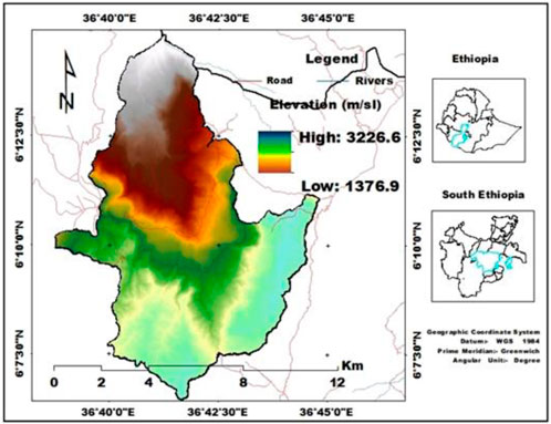
Figure 1. Location map of the study area.
The watershed study had a total population of about 39,646, of which 21,024 (53.03%) were female and 18,622 (46.97%) were male. Mixed farming is the main source of income for the communities. Cattle, donkeys, goats, sheep, and mules are the most common livestock productions in the watershed. Some of the dominant seasonal and perennial crops grown in the watershed are teff (Eragrostis tef), sorghum (Sorghum bicolor), banana (Musa mesta), potato (Solanum tuberosum), taro (Colocasia esculenta), cassava (Manihot esculenta), barley (Hordeum vulgare), wheat (Triticum vulgare), bean (Phaseolus vulgaris), and others. In the study, crops such as korerima (Aframomum corrorima or Ethiopian cardamom) and coffee (Coffea arabica) are also grown in the watershed. Ensete (Ensete ventricosum) is one of the major perennial crops in the study area. It is used as a main staple food crop for the communities in the Sala watershed.
2.2 Data sources and methods of acquisition
The RUSLE model variables are estimated from various sources. This method evaluates the influence of climate, soil, topography, and land use factors on soil erosion (Mete and Bayram, 2024). Both primary and secondary data were used for the RUSLE parameters of the study watershed. Soil sampling and topographic data were the sources of primary data. The secondary source was generated from satellite imagery and meteorological data. The rainfall erosivity factor (R-factor) was derived from annual rainfall data for 15 years (2006–2021) obtained from the Ethiopian National Meteorological Agency. Slope length and slope gradient factor (LS-factor) were determined using a digital elevation model (DEM) from a 1:50,000 scale topographic map with 30 m contour lines of varying heights. The Landsat image was used for the conservation practices (P-factor) and crop management (C-factor).
The soil erodibility factor (K-factor) was determined from field-estimated organic matter, texture, structure, and permeability of the soil of the study area. Three random strata were selected from the watershed elevation, and the major adjacent land use types in each stratum were identified across elevation gradients, of which four were at the top (cultivated land, grazing land, shrubland, and forest land), three in the middle (cultivated land, grazing land, and forest land), and three at lower altitudes (cultivated land, grazing land, and shrubland), with one depth and three replicates per sample field (4 × 3 × 3 × 3 elevations × 1 depth × 3 replicates). Soil samples were collected at three elevations: upper (2,500–3,210), middle (1,900–2,500), and lower (1,391–1900), followed by identifying land use types across elevation gradients. A total of 30 composite soil samples were collected from different current land use types and altitudinal gradients using a zigzag sampling technique at a constant depth of 0–20 cm from upland (12), midland (9), and lowland (9) to calculate the soil erodibility factor (K-factor).
2.3 Determination of the RUSLE model factors
Scientists have developed several methods to estimate soil erosion through experimental, statistical, and physical methods (Beck et al., 2018; Fredj et al., 2024; Wischmeier and Smith, 1965; Williams, 1975; Renard, 1997). RUSLE is an empirical predictive model used to estimate average annual soil loss. The RUSLE model is a widely used, low-cost, non-data-intensive predictive model for agricultural and forestry watersheds (Renard, 1997). This model for estimating soil erosion from sheets and rills has been developed (Yesuph and Dagnew, 2019; Kulimushi et al., 2021a; Kulimushi et al., 2021b) to prioritize areas at risk of soil erosion (Tessema et al., 2020). The RUSLE model was computed using five erosion parameters to calculate the yearly average soil loss in the Sala watershed (Equation (1)) (Renard, 1997):
where A is the mean annual rate of soil loss tonne/hectare/year (t/ha/y), R is the rainfall erosivity factor (MJ mm/ha/hr/year), K is soil-erodibility (t/ha/MJ mm), LS is slope length and slope steepness, C is land-cover management and P is land management factors, respectively.
2.3.1 Rainfall erosivity (R-factor)
The rainfall erosivity factor (R-factor) represents the aggressiveness of rainfall and is related to the amount and rate of runoff that has the potential to cause erosion. Rainfall can remove and transport detached materials in a specific area, and the RUSLE model uses this factor as input in soil loss determination (Hategekimana et al., 2020). The R-factor is strongly influenced by the storm volume, energy, duration and intensity, raindrop shape, precipitation distribution, and subsequent runoff velocity (Farhan and Nawaiseh, 2015; Amellah and Karim, 2021). This factor can be estimated as a function of kinetic energy/raindrops/and their 30-min maximum intensity (I30) (Renard, 1997). However, measurements to generate these variables are not available for Ethiopia as a whole. Therefore, the empirical formula developed by (Hurni, 1985b) was applied to estimate the R-factor for the Ethiopian condition, which has been derived from spatial regression analysis (Helldén, 1987) (Equation 3). The R-factor was developed using the average annual precipitation (P) of the precipitation data of five stations from 2006 to 2021 collected by the Ethiopia National Meteorological Agency (Equation 2).
where R; is the rainfall erosivity factor in MJ mm ha/h/year, and P is the mean annual rainfall (mm/year).
However, to validate the average rainfall, a standard linear regression equation using DEM was used:
Where
The spatial distribution of the rainfall erosivity factor (R-value) over the study’s Sala watershed area is shown in Figure 2. The spatial distribution of different precipitation amounts increases in the mountainous areas of the studied watershed compared to the lowlands, as indicated by the R-factor results of the linear regression model (Table 1; Figure 2). Precipitation and the digital elevation model (DEM) showed a strong correlation (−0.425) (Table 1). Elevation rises by one unit, and precipitation variability is expected to increase by a factor of −0.425 if all other variables stay the same (Table 1). According to Figure 3, the R factor in the study area ranges from 753.95 to 1,552.53 MJ mm/ha/hr/year, with an average value of 1,153.24 MJ mm/ha/hr/year. The results show that the Sala watershed has high rainfall erosivity, which may lead to soil erosion. A higher R-value indicates higher kinetic energy of rainfall and surface runoff, which contributes to higher soil erosion (Balasubramani et al., 2019).
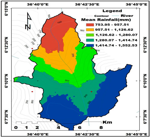
Figure 2. R-factor map of the Sala watershed.
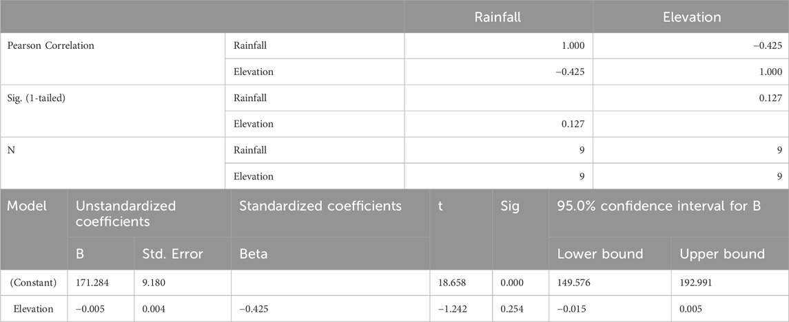
Table 1. Correlation between rainfall and elevation in the Sala watershed.
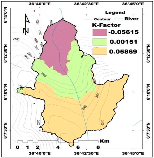
Figure 3. K-factor map of the Sala watershed.
Spatially, the rainfall erosivity distribution was not uniform in the study area due to variations in rainfall shown in Figure 2). The R-value is lower, indicating the low erosivity of rainfall to erode the soil (Asmamaw and Assen, 2019) and low rainfall intensity in the study area (Devatha et al., 2015). The highest elevation in the southern part of the watershed corresponds to the highest annual rainfall values, while the northern part, which is closest to the outlet, has the lowest rainfall values, as shown in Figure 2. This result is supported by the findings of (Belay et al., 2019), who found a strong relationship between elevation and mean annual precipitation. The major problem of soil loss may occur due to high rainfall as the southern part of the study watershed receives high average annual rainfall (Das et al., 2022). Thus, Figure 2 shows that rainfall-induced erosion rates vary across the watershed.
2.3.2 Soil erodibility (K-factor)
Soil erodibility (K-factor) is the soil’s susceptibility to erosion, ease of silt removal, and expected runoff per rainfall contribution (Kayet et al., 2018). K-factor is an assessment of the impact of soil properties on soil loss and the vulnerability of soil to erosion as well as the potential susceptibility of soil to the detachment and transport caused by rainfall and runoff (Alemu and Melesse, 2020; Haile and Fetene, 2012). The influence of soil quality and profile characteristics on soil loss is reflected in the K-factor component (Molla and Sisheber, 2017; Pham et al., 2018; Renard, 1997). Soil texture, organic matter, soil structure, drainage, soil profile depth, and permeability are the primary soil properties that alter the K-factor (Ayalew and Selassie, 2015; Ettazarini et al., 2017; Haregeweyn et al., 2017; Koirala et al., 2019; Molla and Sisheber, 2017; Mohammed et al., 2020; Prasannakumar et al., 2012; Saha, 2018). The K factor was calculated from estimated soil properties, namely texture, organic matter, and structural and permeability (Foster et al., 1981; Panagos et al., 2015). In this study, the K-factor was calculated by the formula of (Equation 4).
where; m = (silt (%) + very fine sand (%)) (100−clay (%)); a = organic matter (%); b = structure code: (1) very structured or particulate, (2) fairly structured, (3) slightly structured and (4) solid, and c = profile permeability code: (1) rapid, (2) moderate to rapid, (3) moderate, (4) moderate to slow, (5) slow and (6) very slow.
The soil erodibility factor shows the mean long-term soil and soil profile response to the erosive power associated with rainfall and runoff (Millward and Mersey, 1999). The K factor indicates the sensitivity of soil to erosion (Kayet et al., 2018). For soil erodibility estimations, soil type and color methods were adapted from (Hurni, 1985a) as indicated in Table 2). Through laboratory analysis, the study area’s soil textures and organic matter values were assessed to estimate the soil erodibility factor (K-value). Figure 3 shows the spatial prediction map of soil K-factor based on Table 2. The results range from −0.056 to 0.058 t/ha/MJ mm, and the average K-factor value is −0.035 t/ha/MJ mm, which is close to 0, indicating low sensitivity to soil erosion (Figure 3). K-value was also negatively correlated with soil permeability (−0.056). These correlations corroborated the general understanding of the soil erodibility vis-à-vis soil texture, organic matter, and permeability (Olaniya et al., 2020). The lowest erodibility was observed in the study area due to the higher organic matter content, which allowed soil fractions to exhibit more excellent aggregate stability (Olaniya et al., 2020). The current findings are in line with earlier research reported on the K-values of tropical soils that range from 0.06 to 0.48 (El-Swaify et al., 1992), and the majority of Ethiopian soils have K-values between 0.05 and 0.6 (FAO–UNDP, 1984).
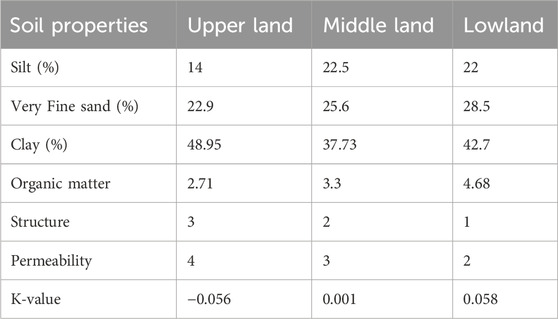
Table 2. Soil properties and their respective K-factor in the Sala watershed.
The lower value of the K factor is associated with the soils having low permeability and low antecedent moisture content. Higher K-values indicate higher erodibility and vulnerability to soil erosion, which could be attributed to low clay and organic matter contents as less aggregation of soil colloids (Bartoli et al., 1992). Soils with good soil structure, high organic matter content, and high permeability are more resistant to erosion. In general, the highest K-value soil is highly affected by erosion and intrinsically susceptible to the erosive force of rainfall, and also intrinsically less resistant to the eroding power of rainfall, whereas the lowest K-value has low soil erodibility and less susceptible to the detaching power of raindrop, and therefore high-resistance to rainfall force (Figure 3).
2.3.3 Slope length and steepness (LS) factor
The LS factor describes the impact of the topographic factors on the rate of soil erosion (Fayas et al., 2019; Wischmeier and Smith, 1978; Haan et al., 1994; Shreevastav et al., 2022; Song et al., 2011). This factor has an impact on the transport capacity of surface runoff (Mandal, 2017; Karna et al., 2021). The steepness gradient affects the flow velocity, whereas the gradient length identifies the distance between the points where erosion begins and the deposition (Renard et al., 1997). The flow velocity on the rate of erosion between the origin and termination of inter-rill processes is influenced by the combined LS factor. The velocity of water flowing over the ground and the slope of the ground surface are dependent parameters (Karna et al., 2021). As slope length increases, soil erosion by water increases due to increased runoff water accumulation. The steeper the slope, the more susceptible it is to soil erosion and vice versa (Ostovari et al., 2017; Wang et al., 2020).
The LS factor was initially suggested and determined by direct slope measurements (Renard, 1997); this method was not suitable for studies conducted at the watershed scale. Accordingly, the S-factor is the actual slope divided by the experimental slope (9%), and the L-factor is obtained by dividing the actual horizontal slope length by the experimentally measured slope length of 22.13 m (Arekhi, 2008; Renard, 1997; Wischmeyer and Smith, 1978). Consequently, the topographic factor raster calculator tool in the ArcGIS environment was utilized in conjunction with a digital elevation model (DEM) to produce a combined LS factor (Atoma, 2018):
Where L is the slope length factor, λ is the slope length (m), and m is the slope–length exponent.
Where F = ratio between rill erosion and inter-rill erosion,
In this study, the steepness factor derived from the slope map of the study area was calculated for high-slope (>9%) and low-slope (<9%) lands, as shown below (Mccool et al., 1987; McCool et al., 1997; Renard, 1997):
Where θ is the slope angle in degrees and σ is the slope gradient in percentage.
The LS factor indicates the impact of topography on the soil erosion process. It is the combined effect of the slope length (L) factor and the slope steepness (S) factor (Figure 4). There is a direct relationship between slope length and erosion rate (Wischmeier and Smith, 1978). As a result, erosion increases as slope length increases. The LS is the ratio of observed soil loss related to the soil loss of a standardized plot (22.13) as indicated in (Schmidt et al., 2019). The LS value is considered to have values between 0.02 and 48 for the Ethiopian condition (Hurni, 1985b), and the study watershed area ranges from 2.86 m at the bottom to 380.15 m at the top (Figure 4). The combined slope LS factor has a greater influence on soil loss in the southern part of the watershed, whereas the northern and central parts of the watershed also contribute less to soil erosion due to the existing slope (Figure 4). As a result, longer slopes see larger accumulations of runoff from a larger area, which raises flow velocities and causes soil loss to increase with slope. As the watershed is mountainous with a steep slope, it inherits a high slope length factor and consequently high overland flow with high velocity (Das et al., 2020). Thus, as the slope length increases, this leads to high overland flow and increases soil erosion and sediment yield in the study area.
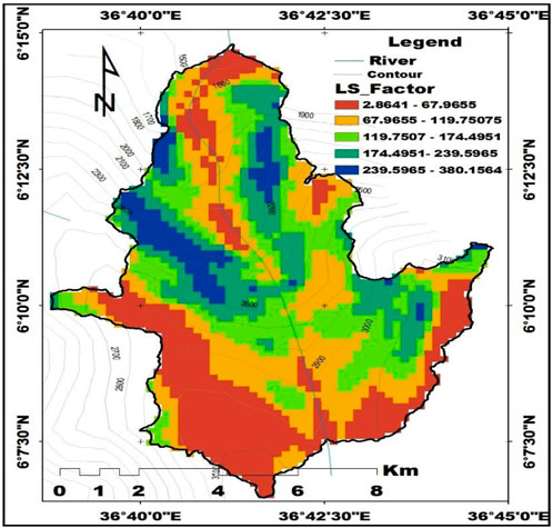
Figure 4. LS-factor map of the Sala watershed.
2.3.4 Cropping and cover management (C-factor)
According to (Hategekimana et al., 2020; Renard, 1997) the C-factor shows how vegetation or plant cover and management interventions contribute to soil loss. The ratio of soil loss from a particular vegetated area to the equivalent soil loss from a fallow area with the same rainfall is known as the cover and management factors (Wolka et al., 2015). This establishes how successful crop and soil management strategies are in preventing soil loss. Cover management (C-factor) is used to associate the relative impact of management strategies on conservation plans (Renard, 1997; Fayas et al., 2019). The vegetation cover of the land use class is used to calculate the C-factor value based on land cover management measures (Karna et al., 2021; Zeleke, 2000) states that the dimensionless C-factor value establishes the proportion of soil loss in distinct regions with varying land cover conditions. Four land use/land cover types were identified as cultivated, forest, grazing, and shrublands (Table 3). The Landsat image was used for the classification and mapping of land use/land cover types using Remote Sensing (RS) and Geographic Information Systems (GIS) techniques.
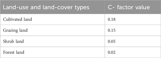
Table 3. Cropping and cover management C-factor values of the study area.
A C-factor map for the study area was made using changes in land use/land cover, which have a significant impact on soil erosion (Kidane et al., 2019). The Sala watershed was classified into four land use/land cover categories, and the C-factor value was assigned (Table 3; Figure 5) for the Ethiopian condition based on the existing literature (Fayas et al., 2019; Olika and Iticha, 2019; Yesuph and Dagnew, 2019; Amsalu and Mengaw, 2014; Girma and Gebre, 2020; Bewket and Teferi, 2009; Wischmeier and Smith, 1978; Hurni, 1985b).
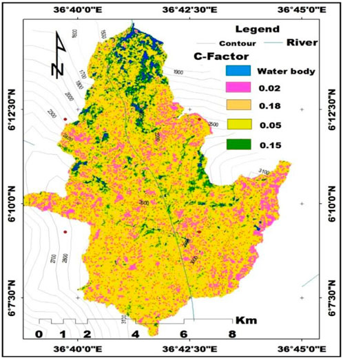
Figure 5. C-factor map of the Sala watershed.
Cover control (C-factor) values in the study watershed range from forest land (0.02) to cultivated land (0.18) (Table 3; Figure 5). The findings demonstrated that from the classified land use/land cover classes, cultivated land predominated (Table 3). The C values show that the maximum amount of cultivated land generates high runoff and is vulnerable to erosion, whereas shrub and forest lands receive the lowest values and are resistant to soil erosion and runoff (Table 3; Figure 5). Among the four land use/land cover classes, cultivated land is the most vulnerable, while forest land use is the least vulnerable to soil erosion (Table 3; Figure 5). Soil is highly eroded, especially when other LULC is converted to cultivated land. The result is in line with the findings of (Negassa et al., 2020). Soil erosion is significantly affected by the land use/land cover conditions of the watershed, according to the present land/land cover analysis findings (Table 3). This conclusion is consistent with prior findings showing that vegetation significantly decreased soil loss and sediment yield (Ebabu et al., 2019; Kidane et al., 2019; Thomas et al., 2018a).
2.3.5 Erosion control practices (P-Factor)
According to (Renard, 1997; Fayas et al., 2019) the erosion control practices factor (P) is also known as the support and conservation practices factor. The support and conservation practices factor (P-factor) measures how conservation practices affect the quantity and rate of soil erosion and runoff (Ayalew and Selassie, 2015; Koirala et al., 2019; Renard, 1997) states that the conservation practice (P-factor) measures the degree to which soil erosion is slowed by support methods such as terracing and contour tillage. On-site, inappropriate physical land management practices were observed. Determining the P-factor is difficult due to the lack of long-term conservation measures and the inconsistent application of conservation practices across the complex and rugged terrain of the study watershed. For these reasons, we computed the P-factor output map using a different estimation method that took into account the type of land use/land cover (Figure 6).
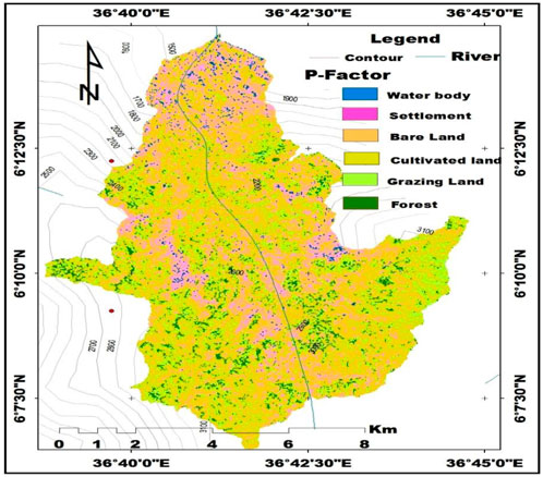
Figure 6. P-factor map of the Sala watershed.
P-factor values varied accordingly, with variations found in the 0.52 to 0.9 range (Table 4; Figure 6). The P-values range from zero (0) to one (1), whereby the values close to zero indicate a good conservation practice and erosion resistance facility, and the values close to one indicate poor conservation practices and no manmade erosion resistance facility (Ganasri and Ramesh, 2016; Olorunfemi et al., 2020; Renard et al., 1997; Wischmeier and Smith, 1978). A value close to forest land (0.52) denotes good conservation practices, while a value close to cultivated land (0.9) denotes poor conservation practices that need soil and water conservation measures (Table 4). The cultivated and barren lands had a maximum p-factor value, which indicated that they are highly vulnerable to soil erosion due to the weakness of soil conservation practices, whereas forest land is resistant to soil erosion and runoff (Table 4; Figure 6).
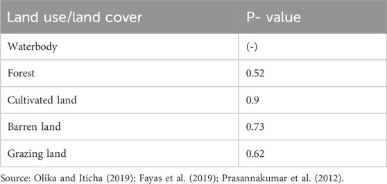
Table 4. P factor with corresponding LULC type in the Sala watershed.
3 Results and discussion
3.1 Soil erosion potential assessment for prioritization of land risk areas using the RUSLE model
The potential soil loss in the Sala watershed was calculated by integrating GIS and remote sensing techniques with the RUSLE soil loss parameters (Figure 7). Erosion loss estimation results showed that the annual soil loss rates in the study area range between 1 and 1875 t/ha/year, with a mean annual soil loss of 312.6 t/ha/year (Table 5; Figure 7). The mean annual soil loss was determined by a cell-by-cell analysis of the soil loss surface by multiplying the RUSLE factors. Based on estimated annual soil loss, soil erosion risk areas were classified into four categories ranging from low to very high risk (Table 5), which was adopted, as noted by (Haregeweyn et al., 2017; Woldemariam et al., 2018). According to the findings, 31.91% of the land was categorized as a low-risk area because it had low erosion rates (1–162 t/ha/year). The remaining areas fall into three categories: medium-risk areas (162–405 t/ha/year) (39.67%), high-risk areas (405–205 t/ha/year) (20.78%), and very high-risk areas (800–1875 t/ha/year) (7.64%) (Table 5). The soil erosion rates have led to a decline in soil fertility, water-holding capacity, and crop productivity (Beek et al., 2016; Haregeweyn et al., 2008; Haileslassie et al., 2005). The watershed area with high soil erosion hotspots requires immediate soil and water conservation planning and implementation measures to reduce further soil loss and the development of gullies on those sites.
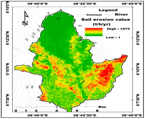
Figure 7. Soil risk areas map of the Sala watershed.
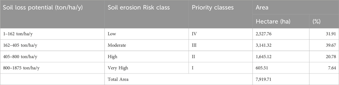
Table 5. Soil loss severity classes in the Sala watershed.
71.58% of the watershed area is classified as having low to moderate erosion severity (the majority of the study area is the low to medium soil erosion category (Table 5). From the total area of the watershed, 28.42% is grouped under high to very high erosion severity, which needs high soil and water conservation measures (Table 5). The watershed risk map shows that some topographically rugged central locations and most of the southwestern and southeast portions of the watershed are more affected by soil erosion than others (Figure 7). Field observation verified that the high vulnerability of the study watershed to soil erosion is associated with the areas cultivated, barren, and degraded lands with steep slopes. Similar findings were reported (Bekele et al., 2022; Kidane et al., 2019), that the variation in soil erosion rate is due to land use, topography, soil type, and various soil and water management activities. These factors collectively contributed to the decline in soil fertility and crop productivity in the study area. Thus, the developed soil erosion risk map is one of the key inputs to decision-support systems in soil resource management and can have an impact on future land use planning in the study area.
The results of this study regarding the spatial location of soil erosion showed that soil loss classes were high to very high in areas with steep slopes, high drainage density, variation in climate, land use, and soil types, and susceptibility to soil erosion. Soil erosion events result from the spatial integration between the physical geographical factors (topography, precipitation, vegetation cover, and soil properties) (Khallouf et al., 2021; Abdo and Salloum, 2017; Djoukbala et al., 2019). Moreover, human activities accelerate soil erosion, inferior maintenance measures, agricultural intensification, population growth, urban expansion, and military actions (Mokhtar et al., 2021; Zubkova et al., 2021; Abdo, 2018; Abdo HazemG., 2022). Soil loss tolerance is a valuable criterion for evaluating the potential for production decline and associated economic repercussions, formulating soil erosion control measures, and implementing soil conservation activities (Stefano et al., 2023). As a result, the quantified mean annual soil loss for the entire watershed was 312.6 t/ha/year, which was larger than the tolerable soil loss of 5–11 t/ha/year that was estimated to ensure agricultural and economic sustainability (Morgan, 2009; Renard et al., 1996). Hence, to maintain soil fertility and agricultural productivity, appropriate soil and water conservation measures should be implemented in the study of the Sala watershed, considering areas of topographic differences to prioritize and minimize the risk of soil erosion.
4 Conclusion
Soil erosion is one of the main challenges to agricultural sustainability that affects people’s livelihoods due to the sustainable land management practices in the study’s Sala watershed. It has huge potential to affect food security by declining agricultural land productivity. In this study, the RUSLE model was used in combination with ground measurements and remote sensing data in a comprehensive spatial assessment of the soil’s sensitivity to erosion. The spatial annual soil loss distribution of the watershed ranges from 1 to 1,875 t/ha/year, and the average annual soil loss rate is 312.6 t/ha/year. Based on the assessment of soil erosion severity, 28.42% of the watershed is classified as having high to very high levels of soil erosion, which require special priority and control measures. To prioritize land management options for the study watershed, all RUSLE parameters were integrated to estimate the distribution of soil erosion potential using an erosion risk area map. Thus, based on soil erosion priority levels, integrated soil and water conservation measures should be implemented in the study area to minimize the soil loss risk. Furthermore, estimating soil erosion risk under the spatial and temporal dynamics of different land uses/land covers should be a focus of future research. In addition to this, further studies should be focused on quantifying gullies in the Sala watershed to advance the precision of soil loss and sediment yield estimation.
Data availability statement
The original contributions presented in the study are included in the article/supplementary material, further inquiries can be directed to the corresponding author.
Author contributions
WD: Writing – original draft, Methodology, Formal Analysis, Writing – review and editing. TY: Conceptualization, Methodology, Supervision, Writing – review and editing. MD: Conceptualization, Methodology, Supervision, Writing – review and editing.
Funding
The author(s) declare that no financial support was received for the research and/or publication of this article.
Acknowledgments
The authors thank the farmers who consented to taking a soil sample from their land. The authors express their gratitude for the assistance of the laboratory technicians at the Chemistry Laboratory Center, Arba Minch University, Ethiopia. Additionally, the authors acknowledge the support of the Ethiopian National Meteorology Agency for providing rainfall data.
Conflict of interest
The authors declare that the research was conducted in the absence of any commercial or financial relationships that could be construed as a potential conflict of interest.
Generative AI statement
The author(s) declare that no Generative AI was used in the creation of this manuscript.
Publisher’s note
All claims expressed in this article are solely those of the authors and do not necessarily represent those of their affiliated organizations, or those of the publisher, the editors and the reviewers. Any product that may be evaluated in this article, or claim that may be made by its manufacturer, is not guaranteed or endorsed by the publisher.
References
Abdo, H., and Salloum, J. (2017). Spatial assessment of soil erosion in Alqerdaha Basin (Syria). Model. Earth Syst. Environ. 3 (1), 26. doi:10.1007/s40808-017-0294-z
Abdo, H. G. (2018). Impacts of war in Syria on vegetation dynamics and erosion risks in Safita area, Tartous, Syria. Reg. Environ. Change 18 (6), 1707–1719. doi:10.1007/s10113-018-1280-3
Abdo, H. G. (2022a). Assessment of landslide susceptibility zonation using frequency ratio and statistical index: a case study of Al-Fawar Basin, Tartous, Syria. Int. J. Environ. Sci. Technol. 19 (4), 2599–2618. doi:10.1007/s13762-021-03322-1
Abdo, H. G. (2022b). Evaluating the potential soil erosion rate based on RUSLE model, GIS, and RS in Khawabi River Basin, Tartous, Syria. DYSONA-Applied Sci. 3 (1), 24–32.doi:10.30493/das.2021.311044
Adimassu, Z., Mekonnen, K., Yirga, C., and Kessler, A. (2014). Effect of soil Bunds on runoff, soil and nutrient losses, and crop yield in the central highlands of Ethiopia. Land Degrad. Dev. 25 (6), 554–564. doi:10.1002/ldr.2182
Alemu, W. G., and Melesse, A. M. (2020). Impacts of longterm conservation measures on ecosystem services in Northwest Ethiopia. Int. Soil Water Conservation Res. 8 (1), 47–55. doi:10.1016/j.iswcr.2019.10.002
Alemu, Z. G. (2005). Causes of instability in cereal production in Ethiopia.University of the Free State, Department of Agricultural Economics.
Alexandridis, T. K., Sotiropoulou, A. M., George, B., Karapetsas, N., and Silleos, N. G. (2015). The effects of seasonality in estimating the C-factor of soil erosion studies. Land Degrad. Dev. 26 (6), 596–603. doi:10.1002/ldr.2223
Amellah, O., and Karim, el M. (2021). Assessment of soil erosion risk severity using GIS, remote sensing and RUSLE model in Oued Laou Basin (North Morocco). Soil Sci. Annu. 72 (3), 1–11. doi:10.37501/soilsa/142530
Amsalu, T., and Mengaw, A. (2014). GIS based soil loss estimation using rusle model: the case of Jabi Tehinan Woreda, ANRS, Ethiopia. Nat. Resour. 2014 5. 616–626. doi:10.4236/nr.2014.511054
Amundson, R., Berhe, A. A., Hopmans, J. W., Olson, C., Sztein, A. E., and Sparks, D. L. (2015). Soil science. Soil and human security in the 21st century. Science 348 (6235), 1261071. doi:10.1126/science.1261071
Aneseyee, A. B., Elias, E., Soromessa, T., and Feyisa, G. L. (2020). Land use/land cover change effect on soil erosion and sediment delivery in the Winike Watershed, Omo Gibe Basin, Ethiopia. Sci. Total Environ. 728, 138776. doi:10.1016/j.scitotenv.2020.138776
Ansari, A., Tayfur, G., and Mohammadi, S. (2024). Assessment of soil erosion and sediment delivery ratio in the Arghandab Catchment, Kandahar province, Afghanistan by using GIS-based RUSLE method. Geomatics, Nat. Hazards Risk 15 (1), 2384602. doi:10.1080/19475705.2024.2384602
Arekhi, S. (2008). Evaluating long-term annual sediment yield estimating potential of GIS interfaced MUSLE model on two micro-watersheds. Pak. J. Biol. Sci. 11, 270–274. doi:10.3923/pjbs.2008.270.274
Asmamaw, L. B., and Assen, A. M. (2019). Identification of soil erosion hotspot areas for sustainable land management in the Gerado Catchment, north-eastern Ethiopia. Remote Sens. Appl. Soc. Environ. 13, 306–317. doi:10.1016/j.rsase.2018.11.010
Atoma, H. (2018). Assessment of soil erosion by rusle model using remote sensing and GIS techniques: a case study of Huluka Watershed, Central Ethiopia. Master’s thesis. Addis Ababa (Ethiopia): Addis Ababa University.
Ayalew, G., and Selassie, Y. G. (2015). Soil loss estimation for soil conservation planning using geographic information system in Guang Watershed, Blue Nile Basin. J. Environ. Earth Sci. 5 (1), 126–134.
Azimi, S., Reza, M., Bazrafshan, O., Panagopoulos, T., and Sardooi, E. R. (2019). Modeling the impact of climate change and land use change scenarios on soil erosion at the Minab Dam Watershed. Sustainability 11 (12), 3353. doi:10.3390/su11123353
Balasubramani, K., Gomathi, M., Bhaskaran, G., and Kumaraswamy, K. (2019). GIS-based spatial multi-criteria approach for characterization and prioritization of micro-watersheds: a case study of semi-arid watershed, South India. Appl. Geomatics 11, 289–307. doi:10.1007/s12518-019-00261-y
Bartoli, F., Burtin, G., and Guerif, J. (1992). Influence of organic matter on aggregation in oxisols rich in gibbsite or in goethite. II. Clay dispersion, aggregate strength and water-stability. Geoderma 54 (1–4), 259–274. doi:10.1016/0016-7061(92)90108-j
Beck, H. E., Zimmermann, N. E., McVicar, T. R., Vergopolan, N., Berg, A., and Wood, E. F. (2018). Present and future köppen-geiger climate classification maps at 1-km resolution. Sci. Data 5 (1), 1–12. doi:10.1038/sdata.2018.214
Beek, C. L. V., Elias, E., Yihenew, G. S., Heesmans, H., Tsegaye, A., Feyisa, H., et al. (2016). Soil nutrient balances under diverse agro-ecological settings in Ethiopia. Nutrient Cycl. Agroecosyst. 106, 257–274. doi:10.1007/s10705-016-9803-0
Bekele, B., Muluneh, A., and Wondrade, N. (2019). Geographic information system (GIS) based soil loss estimation using universal soil loss equation model (USLE) for soil conservation planning in Karesa Watershed, Dawuro Zone, and South West Ethiopia. Int. J. Water Resour. Environ. Eng. 11 (8), 143–158. doi:10.5897/IJWREE2018.0820
Bekele, D. A., Gella, G. W., and Ejigu, M. A. (2022). Erosion risk assessment: a contribution for conservation priority area identification in the sub-basin of Lake Tana, North-Western Ethiopia. Int. Soil Water Conservation Res. 10 (1), 46–61. doi:10.1016/j.iswcr.2021.04.010
Bekele, M. (2021). Geographic information system (GIS) based soil loss estimation using RUSLE model for soil and water conservation planning in Anka_Shashara watershed, southern Ethiopia. Int. J. Hydrology 5 (1), 9–27. doi:10.15406/ijh.2021.05.00260
Belay, A. S., Fenta, A. A., Yenehun, A., Nigate, F., Tilahun, S. A., Moges, M. M., et al. (2019). Evaluation and application of multi-source satellite rainfall product CHIRPS to assess spatio-temporal rainfall variability on data-sparse western margins of Ethiopian highlands. Remote Sens. 11 (22), 2688. doi:10.3390/rs11222688
Belayneh, M., Yirgu, T., and Tsegaye, D. (2019). Potential soil erosion estimation and area prioritization for better conservation planning in Gumara watershed using RUSLE and GIS techniques. Environ. Syst. Res. 8, 20–17. doi:10.1186/s40068-019-0149-x
Benavidez, R., Jackson, B., Maxwell, D., and Norton, K. (2018). A review of the (revised) universal soil loss equation ((R) USLE): with a view to increasing its global applicability and improving soil loss estimates. Hydrology Earth Syst. Sci. 22 (11), 6059–6086. doi:10.5194/hess-22-6059-2018
Bewket, W., and Teferi, E. (2009). Assessment of soil erosion hazard and prioritization for treatment at the watershed level: case study in the Chemoga watershed, Blue Nile Basin, Ethiopia. Land Degrad. Dev. 20 (6), 609–622. doi:10.1002/ldr.944
Blanco-Canqui, H., and Lal, R. (2008). Principles of soil conservation and management. Berlin, Germany: Springer Science and Business Media.
Borrelli, P., Robinson, D. A., Panagos, P., Lugato, E., Yang, J. E., Alewell, C., et al. (2020). Land use and climate change impacts on global soil erosion by water (2015–2070). Proc. Natl. Acad. Sci. U. S. A. 117 (36), 21994–22001. doi:10.1073/pnas.2001403117
Chuenchum, P., Xu, M., and Tang, W. (2019). Estimation of soil erosion and sediment yield in the Lancang–Mekong river using the modified revised universal soil loss equation and GIS techniques. Water 12 (1), 135. doi:10.3390/w12010135
Das, S., Das, R., Bora, P. K., and Olaniya, M. (2022). Estimation of rainfall erosivity (R) using geo-spatial technique for the state of Tripura, India: a comparative study. Indian J. Agric. Sci. 92 (7), 831–835. doi:10.56093/ijas.v92i7.104246
Das, S., Deb, P., Kumar Bora, P., and Katre, P. (2020). Comparison of RUSLE and MMF soil loss models and evaluation of catchment scale best management practices for a mountainous watershed in India. Sustainability 13 (1), 232. doi:10.3390/su13010232
Deb, P., Kiem, A. S., and Willgoose, G. (2019). A linked surface water-groundwater modelling approach to more realistically simulate rainfall-runoff non-stationarity in semi-arid regions. J. Hydrology 575, 273–291. doi:10.1016/j.jhydrol.2019.05.039
Devatha, C. P., Vaibhav, D., and Renukaprasad, M. S. (2015). Estimation of soil loss using USLE model for Kulhan watershed, Chattisgarh-A case study. Aquat. Procedia 4, 1429–1436. doi:10.1016/j.aqpro.2015.02.185
Djoukbala, O., Hasbaia, M., Benselama, O., and Mohamed, M. (2019). Comparison of the erosion prediction models from USLE, MUSLE and RUSLE in a mediterranean watershed, case of Wadi Gazouana (NW of Algeria). Model. Earth Syst. Environ. 5 (2), 725–743. doi:10.1007/s40808-018-0562-6
Ebabu, K., Tsunekawa, A., Haregeweyn, N., Adgo, E., Tsegaye Meshesha, D., Aklog, D., et al. (2019). Effects of land use and sustainable land management practices on runoff and soil loss in the upper Blue Nile Basin, Ethiopia. Sci. Total Environ. 648, 1462–1475. doi:10.1016/j.scitotenv.2018.08.273
Elias, E. (2017). Characteristics of nitisol profiles as affected by land use type and slope class in some Ethiopian highlands. Environ. Syst. Res. 6 (1), 20–15. doi:10.1186/s40068-017-0097-2
El-Swaify, S. A., Zhang, J., Ciesiolka, C. A. A., Palis, R., and Rose, C. W. (1992). Erosion problems and conservation needs of pineapple culture. I Int. Pineapple Symp. 334, 227–240. doi:10.17660/actahortic.1993.334.23
Ettazarini, S., El Jakani, M., and Khalid, N. (2017). Assessment of soil loss risk using integrated remote sensing and geographic information system (GIS) techniques in the Argana Basin, Morocco. Am. J. Innov. Res. Appl. Sci. 4, 186–194.
Ettazarini, S., and Mustapha, El J. (2017). Assessment of water suitability for irrigation purposes in qalaat Mgouna area, Morocco. Am. Journ. Innov. Res. Appl. S. C. 4 (5), 126–135.
FAO–UNDP (1984). Methodology used in the development of soil loss rate map of the Ethiopian highlands. Field document 5, Ethiopia (Addis Ababa): FAO/UNDP.
Farhan, Y., and Nawaiseh, S. (2015). Spatial assessment of soil erosion risk using RUSLE and GIS techniques. Environ. Earth Sci. 74, 4649–4669. doi:10.1007/s12665-015-4430-7
Fayas, C. M., Abeysingha, N. S., Nirmanee, K. G. S., Samaratunga, D., and Mallawatantri, A. (2019). Soil loss estimation using rusle model to prioritize erosion control in KELANI River Basin in Sri Lanka. Int. Soil Water Conservation Res. 7 (2), 130–137. doi:10.1016/j.iswcr.2019.01.003
Foster, G. R., McCool, D. K., Renard, K. G., and Moldenhauer, W. C. (1981). Conversion of the universal soil loss equation to SI metric units. J. Soil Water Conservation 36 (6), 355–359. doi:10.1080/00224561.1981.12436140
Fredj, A., Ghernaout, R., Dahmani, S., and Remini, B. (2024). Assessing soil erosion through the implementation of the RUSLE model and geospatial technology in the Isser watershed, Northern Algeria. Water Supply 24 (7), 2487–2505. doi:10.2166/ws.2024.154
Gachene, C. K. K., Nyawade, S. O., and Karanja, N. N. (2020). Soil and water conservation: an overview. Zero Hunger, 810–823. doi:10.1007/978-3-319-95675-6_91
Ganasri, B. P., and Ramesh, H. (2016). Assessment of soil erosion by RUSLE model using remote sensing and GIS-A case study of Nethravathi Basin. Geosci. Front. 7 (6), 953–961. doi:10.1016/j.gsf.2015.10.007
Gashaw, T., Tulu, T., and Argaw, M. (2018). Erosion risk assessment for prioritization of conservation measures in Geleda watershed, Blue Nile Basin, Ethiopia. Environ. Syst. Res. 6 (1), 1–14. doi:10.1186/s40068-016-0078-x
Gashaw, T., Tulu, T., Argaw, M., and Worqlul, A. W. (2019). Modeling the impacts of land use–land cover changes on soil erosion and sediment yield in the Andassa watershed, upper Blue Nile Basin, Ethiopia. Environ. Earth Sci. 78, 679–722. doi:10.1007/s12665-019-8726-x
Gelagay, H. S., and Minale, A. S. (2016). Soil loss estimation using GIS and remote sensing techniques: a case of Koga Watershed, Northwestern Ethiopia. Int. Soil Water Conservation Res. 4 (2), 126–136. doi:10.1016/j.iswcr.2016.01.002
Gessesse, G. D., Mansberger, R., and Klik, A. (2015). Assessment of rill erosion development during erosive storms at Angereb watershed, lake Tana sub-basin in Ethiopia. J. Mt. Sci. 12, 49–59. doi:10.1007/s11629-014-3151-9
Ghosh, S., and Kundu, S. (2025). Fluvial anomaly as indicator of tectonically active landscapes: a study in the Darjeeling Sikkim Himalaya, India. DYSONA-Applied Sci. 6 (1), 70–85.
Girma, R., and Gebre, E. (2020). Spatial modeling of erosion hotspots using GIS-RUSLE interface in Omo-Gibe river basin, southern Ethiopia: implication for soil and water conservation planning. Environ. Syst. Res. 9 (1), 19–14. doi:10.1186/s40068-020-00180-7
Haan, C. T., Barfield, B. J., and Hayes, J. C. (1994). Design hydrology and sedimentology for small catchments. Amsterdam, Netherlands: Elsevier.
Haile, G. W., and Fetene, M. (2012). Assessment of soil erosion hazard in Kilie Catchment, East shoa, Ethiopia. Land Degrad. Dev. 23 (3), 293–306. doi:10.1002/ldr.1082
Haile, W. (2012). Appraisal of Erythrina Bruci as a source for soil nutrition on Nitisols of South Ethiopia. Int. J. Agric. Biol. 14 (3).
Haileslassie, A., Priess, J., Veldkamp, E., Teketay, D., and Lesschen, J. P. (2005). Assessment of soil nutrient depletion and its spatial variability on smallholders’ mixed farming systems in Ethiopia using partial versus full nutrient balances. Agric. Ecosyst. Environ. 108 (1), 1–16. doi:10.1016/j.agee.2004.12.010
Haregeweyn, N., Poesen, J., Deckers, J., Nyssen, J., Haile, M., Govers, G., et al. (2008). Sediment-bound nutrient export from micro-dam catchments in northern Ethiopia. Land Degrad. Dev. 19 (2), 136–152. doi:10.1002/ldr.830
Haregeweyn, N., Tsunekawa, A., Poesen, J., Tsubo, M., Meshesha, D. T., Fenta, A. A., et al. (2017). Comprehensive assessment of soil erosion risk for better land use planning in river basins: case study of the upper Blue Nile River. Sci. Total Environ. 574, 95–108. doi:10.1016/j.scitotenv.2016.09.019
Hategekimana, Y., Allam, M., Meng, Q., Nie, Y., and Mohamed, E. (2020). Quantification of soil losses along the coastal protected areas in Kenya. Land 9 (5), 137. doi:10.3390/land9050137
Helldén, U. (1987). “An assessment of woody biomass, community forests, land use and soil erosion in Ethiopia,” in A feasibility study on the use of remote sensing and GIS [geographical information system]-analysis for planning purposes in developing countries. Lund, Sweden: Lund University Press.
Hurni, H. (1985a). An ecosystem approach to soil conservation. Soil Eros. Conservation 73, 759–771. Ankeny: Soil Conservation Society of America.
Hurni, H. (1985b). Erosion-productivity-conservation systems in Ethiopia. Bromley, Kent, England: Chartwell-Bratt.
Hurni, H., and Meyer, K. (2002). A world soils agenda: discussing international actions for the sustainable use of soils. Berne: Geographica Bernensia.
Hurni, K., Zeleke, G., Kassie, M., Tegegne, B., Kassawmar, T., Teferi, E., et al. (2015). Economics of land degradation (ELD) Ethiopia case study: soil degradation and sustainable land management in the rainfed agricultural areas of Ethiopia: an assessment of the economic implications. Report for the Economics of Land Degradation Initiative. 94.
Ighodaro, I. D., Lategan, F. S., and Yusuf, S. F. G. (2013). The impact of soil erosion on agricultural potential and performance of Sheshegu community farmers in the Eastern cape of South Africa. J. Agric. Sci. 5 (5), 140. doi:10.5539/jas.v5n5p140
Jayasekara, MJPTM, Kadupitiya, H. K., and Vitharana, U. W. A. (2018). Mapping of soil erosion hazard zones of Sri Lanka. Trop. Agric. Res. 29, 135. doi:10.4038/tar.v29i2.8284
Karna, B. K., Shrestha, S., and Koirala, H. L. (2021). Geo-information modeling of soil erosion for sustainable agriculture land management in Sambhunath municipality. J. Geoinformat., Nepal 20 (1), 47–57. doi:10.3126/njg.v20i1.39478
Karydas, C. G., Panagos, P., and Gitas, I. Z. (2014). A classification of water erosion models according to their geospatial characteristics. Int. J. Digital Earth 7 (3), 229–250. doi:10.1080/17538947.2012.671380
Kassaye, G. L., and Abay, G. (2019). Soil degradation extent and dynamics of soil fertility improvement technologies in majete watershed, North Ethiopia. J. Soil Sci. Environ. Manag. 10 (3), 39–45. doi:10.5897/jssem2018.0730
Kayet, N., Pathak, K., Chakrabarty, A., and Sahoo, S. (2018). Evaluation of soil loss estimation using the RUSLE model and SCS-CN method in hillslope mining areas. Int. Soil Water Conservat. Res. 6 (1), 31–42. doi:10.1016/j.iswcr.2017.11.002
Khallouf, A., Talukdar, S., Harsányi, E., Abdo, H. G., and Mohammed, S. (2021). Risk assessment of soil erosion by using CORINE model in the western part of Syrian Arab Republic. Agric. Food Secur. 10, 1–15. doi:10.1186/s40066-021-00295-9
Kidane, M., Bezie, A., Kesete, N., and Tolessa, T. (2019). The impact of land use and land cover (LULC) dynamics on soil erosion and sediment yield in Ethiopia. Heliyon 5 (12), e02981. doi:10.1016/j.heliyon.2019.e02981
Koirala, P., Thakuri, S., Joshi, S., and Chauhan, R. (2019). Estimation of soil erosion in Nepal using a RUSLE modeling and geospatial tool. Geosciences 9 (4), 147. doi:10.3390/geosciences9040147
Kulimushi, L. C., Choudhari, P., Mubalama, L. K., and Banswe, G. T. (2021a). GIS and remote sensing-based assessment of soil erosion risk using RUSLE model in South-kivu province, eastern, democratic Republic of Congo. Geomatics, Nat. Hazards Risk 12 (1), 961–987. doi:10.1080/19475705.2021.1906759
Kulimushi, L. C., Maniragaba, A., Choudhari, P., Ahmed, E., Uwemeye, J., Rushema, E., et al. (2021b). Evaluation of soil erosion and sediment yield spatio-temporal pattern during 1990–2019. Geomatics, Nat. Hazards Risk 12 (1), 2676–2707. doi:10.1080/19475705.2021.1973118
Lanckriet, T., Puleo, J. A., Masselink, G., Turner, I. L., Conley, D., Blenkinsopp, C., et al. (2014). Comprehensive field study of swash-zone processes. II: sheet flow sediment concentrations during quasi-steady backwash. J. Waterw. Port, Coast. Ocean Eng. 140 (1), 29–42. doi:10.1061/(asce)ww.1943-5460.0000209
Liu, B., Xie, Y., Li, Z., Liang, Y., Zhang, W., Fu, S., et al. (2020). The assessment of soil loss by water erosion in China. Int. Soil Water Conservation Res. 8 (4), 430–439. doi:10.1016/j.iswcr.2020.07.002
Mandal, U. K. (2017). Geo-information-based soil erosion modeling for sustainable agriculture development in Khadokhola Watershed, Nepal. Land Cover Change Its Eco-Environmental Responses Nepal, 223–241. doi:10.1007/978-981-10-2890-8_10
McCool, D. K., Foster, G. R., and Weesies, G. A. (1997). “Slope length and steepness factors (LS),” in Predicting soil erosion by water: a guide to conservation planning with the revised universal soil loss equation (RUSLE), 703. Washington, DC: US Department of Agriculture.
Mccool, D. K., Brown, L. C., Foster, G. R., Mutchler, C. K., and Meyer, L. D. (1987). Revised slope steepness factor for the universal soil loss equation. Trans. ASAE 30 (5), 1387–1396. doi:10.13031/2013.30576
McNeill, J. R. (2001). Something new under the sun: an environmental history of the twentieth-century world (the global century series). New York: WW Norton and Company.
Mekonnen, M., Keesstra, S. D., Stroosnijder, L., Baartman, J. E. M., and Maroulis, J. (2015). Soil conservation through sediment trapping: a review. Land Degrad. Dev. 26 (6), 544–556. doi:10.1002/ldr.2308
Mete, B., and Bayram, A. (2024). Effects of sediment-storage dams on suspended sediment transport in the Sera Lake Watershed, Northeast Turkey. Environ. Earth Sci. 83 (8), 258. doi:10.1007/s12665-024-11572-8
Mihara, M., Yamamoto, N., and Ueno, T. (2005). Application of USLE for the prediction of nutrient losses in soil erosion processes. Paddy Water Environ. 3, 111–119. doi:10.1007/s10333-005-0006-6
Millward, A. A., and Mersey, J. E. (1999). Adapting the RUSLE to model soil erosion potential in a mountainous tropical watershed. Catena 38 (2), 109–129. doi:10.1016/s0341-8162(99)00067-3
Mohammed, S., Alsafadi, K., Talukdar, S., Kiwan, S., Hennawi, S., Alshihabi, O., et al. (2020). Estimation of soil erosion risk in southern part of Syria by using RUSLE integrating geo informatics approach. Remote Sens. Appl. Soc. Environ. 20, 100375. doi:10.1016/j.rsase.2020.100375
Mohammed, S., Gemechu, G. F., Aliyi, M., and Gemechu, T. M. (2022). Prioritizing management options using a risk assessment for soil erosion based on GIS, remote sensing, and RUSLE. In: A Case Study of Midhagdu Watershed, Eastern Ethiopia.
Moisa, M. B., Negash, D. A., Merga, B. B., and Gemeda, D. O. (2021). Impact of land-use and land-cover change on soil erosion using the RUSLE model and the geographic information system: a case of Temeji Watershed, Western Ethiopia. J. Water Clim. Change 12 (7), 3404–3420. doi:10.2166/wcc.2021.131
Moisa, M. B., Niguse Dejene, I., Merga, B. B., and Gemeda, D. O. (2022). Soil loss estimation and prioritization using geographic information systems and the RUSLE model: a case study of the Anger rRiver sub-basin, western Ethiopia. J. Water Clim. Change 13 (3), 1170–1184. doi:10.2166/wcc.2022.433
Mokhtar, A., Jalali, M., He, H., Al-Ansari, N., Ahmed, E., Alsafadi, K., et al. (2021). Estimation of SPEI meteorological drought using machine learning algorithms. IEEe Access 9, 65503–65523. doi:10.1109/access.2021.3074305
Molla, H. K. (2017). The effect of degree of saturation on the results of direct shear tests of C-Φ soil.
Molla, T., and Sisheber, B. (2017). Estimating soil erosion risk and evaluating erosion control measures for soil conservation planning at Koga watershed in the highlands of Ethiopia. Solid Earth. 8 (1), 13–25. doi:10.5194/se-8-13-2017
Morgan, R. P. C. (2009). Soil erosion and conservation. National Soil Resources Institute, Cranfield University.
Negash, D. A., Moisa, M. B., Merga, B. B., Sedeta, F., and Gemeda, D. O. (2021). Soil erosion risk assessment for prioritization of sub-watershed: the case of Chogo Watershed, Horo Guduru Wollega, Ethiopia. Environ. Earth Sci. 80 (17), 589. doi:10.1007/s12665-021-09901-2
Negassa, M. D., Mallie, D. T., and Gemeda, D. O. (2020). Forest cover change detection using geographic information systems and remote sensing techniques: a spatio-temporal study on Komto protected forest priority area, East Wollega Zone, Ethiopia. Environ. Syst. Res. 9, 1–14. doi:10.1186/s40068-020-0163-z
Nkonya, E., Anderson, W., Kato, E., Koo, J., Mirzabaev, A., von Braun, J., et al. (2016). Global cost of land degradation. Econ. Land Degrad. Improvement–A Glob. Assess. Sustain. Dev., 117–165. doi:10.1007/978-3-319-19168-3_6
Ochoa Tocachi, B. F., Buytaert, W., De Bievre, B., Célleri, R., Crespo, P., Villacís, M., et al. (2016). Impacts of land use on the hydrological response of tropical Andean catchments. Hydrol. Process. 30 (22), 4074–4089. doi:10.1002/hyp.10980
Okenmuo, F. C., and Ewemoje, T. A. (2023). Estimation of soil water erosion using RUSLE, GIS, and remote sensing in Obibia River watershed, Anambra, Nigeria. DYSONA-Applied Sci. 4 (1), 6–14. doi:10.30493/das.2022.349144
Olaniya, M., Kumar Bora, P., Das, S., and Chanu, P. H. (2020). Soil erodibility indices under different land uses in Ri-Bhoi district of Meghalaya (India). Sci. Rep. 10 (1), 14986. doi:10.1038/s41598-020-72070-y
Olika, G., and Iticha, B. (2019). Assessment of soil erosion using RUSLE and GIS techniques: a case of Fincha’a watershed, western Ethiopia. American-Eurasian J. Agric. Environ. Sci. 19 (1), 31–36.
Olorunfemi, I. E., Fasinmirin, J. T., Olufayo, A. A., and Komolafe, A. A. (2020). GIS and remote sensing-based analysis of the impacts of land use/land cover change (LULCC) on the environmental sustainability of Ekiti state, southwestern Nigeria. Environ. Dev. Sustain. 22, 661–692. doi:10.1007/s10668-018-0214-z
Ostovari, Y., Ghorbani-Dashtaki, S., Bahrami, H.-A., Naderi, M., and Dematte, J. A. M. (2017). Soil loss estimation using RUSLE model, GIS and remote sensing techniques: a case study from the Dembecha watershed, Northwestern Ethiopia. Geoderma Reg. 11, 28–36. doi:10.1016/j.geodrs.2017.06.003
Ozsahin, E., Duru, U., and Eroglu, I. (2018). Land use and land cover changes (LULCC), a key to understand soil erosion intensities in the Maritsa Basin. Water 10 (3), 335. doi:10.3390/w10030335
Panagos, P., Borrelli, P., Meusburger, K., Alewell, C., Lugato, E., and Montanarella, L. (2015). Estimating the soil erosion cover-management factor at the European scale. Land Use Policy 48, 38–50. doi:10.1016/j.landusepol.2015.05.021
Pham, T. G., Degener, J., and Kappas, M. (2018). Integrated universal soil loss equation (USLE) and geographical information system (GIS) for soil erosion estimation in A sap basin: central Vietnam. Int. Soil Water Conservation Res. 6 (2), 99–110. doi:10.1016/j.iswcr.2018.01.001
Pimentel, D., and Burgess, M. (2013). Soil erosion threatens food production. Agriculture 3 (3), 443–463. doi:10.3390/agriculture3030443
Prasannakumar, V., Vijith, H., Abinod, S., and Geetha, NJGF (2012). Estimation of soil erosion risk within a small mountainous sub-watershed in Kerala, India, using revised universal soil loss equation (RUSLE) and geo-information technology. Geosci. Front. 3 (2), 209–215. doi:10.1016/j.gsf.2011.11.003
Reichmann, O., Chen, Y., and Iggy, L. M. (2013). Spatial model assessment of P transport from soils to waterways in an eastern Mediterranean watershed. Water 5 (1), 262–279. doi:10.3390/w5010262
Renard, F., Ortoleva, P., and Gratier, J. P. (1997). Pressure solution in sandstones: influence of clays and dependence on temperature and stress. Tectonophysics 280 (3–4), 257–266. doi:10.1016/s0040-1951(97)00039-5
Renard, K. G. (1997). “Predicting soil erosion by water: a guide to conservation planning with the revised universal soil loss equation (RUSLE),” in Agricultural research service. US Department of Agriculture. doi:10.32747/1997.7598424
Renard, K. G., Foster, G. R., Weesies, G. A., McCool, D. K., and Yoder, D. C. (1996). Predicting soil erosion by water: a guide to conservation planning with the revised universal soil loss equation (RUSLE). Agric. Handb. 703, 400. doi:10.21203/rs.3.rs-1877352/v1
Richi, S. M. (2025). Integrated RUSLE-GIS modeling for enhancing soil erosion management in Ghamima River Basin, Syria. DYSONA-Applied Sci. 6 (1), 104–112. doi:10.30493/das.2024.479955
Saha, S. (2018). Geo-environmental evaluation for exploring potential soil erosion areas of Jainti River Basin using AHP model, eastern India. Univers. J. Environ. Res. Technol. 7 (1) 38–55.
Schmidt, S., Simon, T., and Meusburger, K. (2019). Modification of the RUSLE slope length and steepness factor (LS-Factor) based on rainfall experiments at steep alpine grasslands. MethodsX 6, 219–229. doi:10.1016/j.mex.2019.01.004
Shreevastav, B. B., Tiwari, K. R., Mandal, R. A., and Singh, B. (2022). Flood risk modeling in southern Bagmati Corridor, Nepal’(a study from Sarlahi and Rautahat, Nepal). Prog. Disaster Sci. 16, 100260. doi:10.1016/j.pdisas.2022.100260
Song, X., Du, L., Kou, C., and Ma, Y. (2011). “Assessment of soil erosion in water source area of the danjiangkou reservoir using USLE and GIS,” in Information Computing and Applications: Second International Conference, ICICA 2011, Qinhuangdao, China, October 28–31, 2011. (Springer), 57–64. doi:10.1007/978-3-642-25255-6_8
Sonneveld, B. G. J. S., Keyzer, M. A., and Stroosnijder, L. (2011). Evaluating quantitative and qualitative models: an application for nationwide water erosion assessment in Ethiopia. Environ. Model. Softw. 26 (10), 1161–1170. doi:10.1016/j.envsoft.2011.05.002
Stefano, C. D., Nicosia, A., Pampalone, V., and Ferro, V. (2023). Soil loss tolerance in the context of the European green deal. Heliyon 9 (1), e12869. doi:10.1016/j.heliyon.2023.e12869
Tamene, L., Park, S. J., Dikau, R., and Vlek, P. L. G. (2006). Analysis of factors determining sediment yield variability in the highlands of northern Ethiopia. Geomorphology 76 (1–2), 76–91. doi:10.1016/j.geomorph.2005.10.007
Taye, G., Vanmaercke, M., Poesen, J., Van Wesemael, B., Tesfaye, S., Teka, D., et al. (2018). Determining RUSLE P-and C-factors for stone bunds and trenches in rangeland and cropland, North Ethiopia. Land Degrad. Dev. 29 (3), 812–824. doi:10.1002/ldr.2814
Teferi, E., Bewket, W., and Simane, B. (2016). Effects of land use and land cover on selected soil quality indicators in the headwater area of the blue nile basin of Ethiopia. Environ. Monit. Assess. 188, 83–12. doi:10.1007/s10661-015-5086-1
Tesfahunegn, G. B., Tamene, L., and Vlek, P. L. G. (2014). Soil erosion prediction using Morgan-Morgan-Finney model in a GIS environment in northern Ethiopia catchment. Appl. Environ. Soil Sci. 2014, 1–15. doi:10.1155/2014/468751
Tessema, Y. M., Jasińska, J., Tiki Yadeta, L., Świtoniak, M., Puchałka, R., and Gebregeorgis, E. G. (2020). Soil loss estimation for conservation planning in the Welmel Watershed of the genale Dawa Basin, Ethiopia. Agronomy 10 (6), 777. doi:10.3390/agronomy10060777
Thomas, J., Joseph, S., and Thrivikramji, K. P. (2018a). Assessment of soil erosion in a tropical mountain river basin of the southern western Ghats, India using RUSLE and GIS. Geosci. Front. 9 (3), 893–906. doi:10.1016/j.gsf.2017.05.011
Thomas, J., Joseph, S., and Thrivikramji, K. P. (2018b). Estimation of soil erosion in a rain shadow river basin in the southern western Ghats, India using RUSLE and transport limited sediment delivery function. Int. Soil Water Conservation Res. 6 (2), 111–122. doi:10.1016/j.iswcr.2017.12.001
Wang, Z., Wang, G., Zhang, Y., and Wang, R. (2020). Quantification of the effect of soil erosion factors on soil nutrients at a small watershed in the Loess Plateau, northwest China. J. Soils Sediments 20, 745–755. doi:10.1007/s11368-019-02458-5
Williams, J. R. (1975). “Sediment-yield prediction with universal equation using runoff energy factor1,” in Present and prospective technology for predicting sediment yield and sources: proceedings of the sediment-yield workshop, USDA sedimentation laboratory, Oxford, Miss (Washington, DC: Agricultural Research Service, US Department of Agriculture), 244–252.
Wischmeier, W. H., and Smith, D. D. (1965). “Predicting rainfall-erosion losses from cropland East of the rocky mountains: guide for selection of practices for soil and water conservation,” in Agricultural research service. US Department of Agriculture.
Wischmeier, W. H., and Smith, D. D. (1978). Predicting rainfall erosion losses: a guide to conservation planning. Maryland: Department of Agriculture, Science and Education Administration.
Wischmeyer, W. H., and Smith, D. O. (1978). Prediction rainfall erosion loss. Maryland: USDA, Agric. Handb. No 537.
Woldemariam, G. W., Derribew Iguala, A., Tekalign, S., and Reddy, R. U. (2018). Spatial modeling of soil erosion risk and its implication for conservation planning: the case of the Gobele watershed, East Hararghe Zone, Ethiopia. Land 7 (1), 25. doi:10.3390/land7010025
Wolka, K., Mulder, J., and Biazin, B. (2018). Effects of soil and water conservation techniques on crop yield, runoff and soil loss in sub-saharan Africa: a review. Agric. Water Manag. 207, 67–79. doi:10.1016/j.agwat.2018.05.016
Wolka, K., Tadesse, H., Garedew, E., and Yimer, F. (2015). Soil erosion risk assessment in the Chaleleka Wetland Watershed, Central Rift Valley of Ethiopia. Environ. Syst. Res. 4 (1), 5–12. doi:10.1186/s40068-015-0030-5
Yesuph, A. Y., and Dagnew, A. B. (2019). Soil erosion mapping and severity analysis based on RUSLE model and local perception in the Beshillo catchment of the Blue Nile Basin, Ethiopia. Environ. Syst. Res. 8, 17–21. doi:10.1186/s40068-019-0145-1
Zeleke, G. (2000). Landscape dynamics and soil erosion process modelling in the north-western Ethiopian highlands. Volume 16 of Geographica Bernensia: African studies series. University of Berne, Institute of Geography.
Zhang, S., Fan, W., Li, Y., and Yi, Y. (2017). The influence of changes in land use and landscape patterns on soil erosion in a watershed. Sci. Total Environ. 574, 34–45. doi:10.1016/j.scitotenv.2016.09.024
Keywords: soil erosion, RUSLE, land risk, prioritization, Sala watershed
Citation: Debebe W, Yirgu T and Debele M (2025) Assessing soil erosion potential for prioritization of land risk area in the Sala watershed of Ari zone, South Ethiopia. Front. Environ. Sci. 13:1495923. doi: 10.3389/fenvs.2025.1495923
Received: 13 September 2024; Accepted: 17 April 2025;
Published: 02 May 2025.
Edited by:
Qiang Li, University of Houston–Downtown, United StatesReviewed by:
Susanta Das, University of Florida, United StatesZhijia Gu, Xinyang Normal University, China
Copyright © 2025 Debebe, Yirgu and Debele. This is an open-access article distributed under the terms of the Creative Commons Attribution License (CC BY). The use, distribution or reproduction in other forums is permitted, provided the original author(s) and the copyright owner(s) are credited and that the original publication in this journal is cited, in accordance with accepted academic practice. No use, distribution or reproduction is permitted which does not comply with these terms.
*Correspondence: Woldeyes Debebe, d29sZGUuZGViZUBnbWFpbC5jb20=