 Xianglong Kong1,2†
 Yutong Wu
 Peng Cui
- 1College of Landscape Architecture, Northeast Forestry University, Harbin, China
- 2Faculty of Innovation and Design, City University of Macau, Taipa, Macao SAR, China
- 3College of Architecture and Art Design, Inner Mongolia University of Science and Technology, Inner Mongolia, China
Indroduction: Northeast China is a traditional industrial region. Studying the dynamic land utilization efficiency during urbanization is crucial for understanding the human-land relationship in cities facing economic decline.
Methods: Using land utilization and population data from 2000 to 2020, a dynamic land utilization efficiency index was developed to identify patterns in land utilization dynamics at the district and county level and assess the coordination of human-land relationships at the municipal level. The spatial structural relationships among districts and counties are analysed using the Getis-Ord Gi* statistical model, while the co ordination mechanisms of human-land interactions are explored through the Kaya identity and the Logarithmic Mean Divisia Index (LMDI).
Results: The results demonstrate that 40.9% of counties suffer from low land utilization efficiency. 57.6% of cities experience simultaneous population decline and expansion of urban-rural construction land. The de-industrialization process in the region is not limited to a shift toward the service sector. 70.5% of cities exhibit significant characteristics of farmland restoration and reforestation during the process of urban and rural construction land reduction. Overall, the complex relationship between population migration and land use efficiency has a significant impact on the urban development patterns in the three northeastern provinces.
Discussion: Net population inflow has not significantly improved land use efficiency, and the decrease in the proportion of permanent residents, along with the increase in the floating population, are key factors influencing the changes in urban-rural construction land. This study reveals the spatial differentiation of land use efficiency and its complex interaction with human-land relationships during the de-industrialization process, providing a theoretical basis for land management and regional sustainable development in traditional industrial cities.
1 Introduction
Since the 1990s, urbanization has emerged as a key driver of global economic development, profoundly influencing the global ecological environment (Jiang et al., 2016). Since the reform and opening up, China has experienced the largest and fastest urbanization in history. The urbanization rate has increased from 17.92% in 1978 to 59.58% in 2018, with an annual growth rate of nearly 1.04% (Lin and Zhu, 2021). In this process, de-industrialization has gradually become a major economic phenomenon faced by certain countries and regions. De-industrialization is typically manifested by a decline in the share of manufacturing, an increase in resource-dependent economies, and the relative expansion of the tertiary sector, which leads to the decline of industrial production and, consequently, affects urban spatial structures and land use efficiency. De-industrialization refers to a reduction in the proportion of the industrial sector within the overall economy, especially the decline in the output and employment of manufacturing, while the share of the service sector rises, causing resources to flow from the industrial sector to the service sector and other fields. De-industrialization is not unique to China; many other countries have undergone similar economic transformations (Niftiyev, 2025). For instance, the Dutch disease is a classic example, particularly prominent in resource-rich countries. Niftiyev explored the impact of Dutch disease on Azerbaijan’s economic de-industrialization, emphasizing the necessity of institutional reforms and policy interventions (Niftiyev, 2020). This research provides an important perspective for the sustainable development of resource-dependent economies, revealing how policy regulation can alleviate the negative effects of excessive resource dependence. The Northeast China, among the earliest to industrialize, have gradually encountered the “development trap” issues characteristic of the later stages of industrialization (Wu, 2010). In contrast to economically advanced regions, where the growth of the service sector is accompanied by increasing populations and expanding construction land, the Northeast China—once dominated by traditional industries—have experienced a simultaneous occurrence of population loss and urban land expansion. Since 2014, this region has faced a range of urban development challenges, including population decline, economic recession, and inefficient land utilization, which markedly differ from the de-industrialization trends observed in more developed regions.
Previous studies have primarily explored the distribution and evolution of population and land utilization in cities by integrating multi-source data, such as remote sensing, focusing on factors like socio-economic and natural geographical conditions (Azhdari et al., 2018; Dewan and Yamaguchi, 2009; Taubenböck et al., 2009). Some studies have used elasticity coefficient to quantify the relationship between the growth rate of urban population and urban construction land (Yu et al., 2019). However, these studies typically address the shift in urban construction land from a unidirectional perspective, offering limited exploration of the mechanisms of human-land interaction. Additionally, other research has taken a large-scale approach to investigate the relative importance of urban population growth and GDP growth in driving urban land expansion across over 300 cities worldwide, considering variations in regions, economic development levels, and governance types (Mahtta et al., 2022). Relevant studies indicate that the annual growth rate of per capita GDP in China accounts for approximately 50% of urban land expansion. However, in the research models, neither population nor other variables change in coordination with urban expansion, with the research perspective being largely macro-level (Seto et al., 2011). Such research content involves multi-level analysis, including provincial, municipal, and other levels in addition to the research of global cities (Li et al., 2020; Luo et al., 2018; Han et al., 2024). Within the context of domestic research in China, earlier discussions on de-industrialization were primarily focused on the southeastern coastal regions or more developed urban clusters, with relatively few studies conducted at the county level or below. Developed economies often enter the de-industrialization process first and shift towards the development of the tertiary industry. There is a lack of research on economically backward areas or traditional industrial cities, neglecting the issue of de-industrialization in China’s remote areas (Chaolin et al., 2012). Different from the city-centered urbanization in China’s coastal areas, the urbanization of Northeast China has been primarily driven by agricultural modernization and economic liberalization, with urban region generally exhibiting a single-core characteristic (Liu et al., 2014). Given the region’s unique background of industrial decline, the urbanization process in Northeast China holds distinct research significance. Achieving a harmonious relationship between human-land is a complex process, influenced by a variety of decisive factors (Smailes et al., 2002).
In terms of research methods, some scholars analyzed the spatio-temporal pattern of rural in situ urbanization (RISU) through RISU and rural in situ urbanization index (RISUI) based on Beijing-Tianjin-Hebei land utilization change data and explored the driving mechanisms, but did not address the contradictions in human-land relations and the dynamic evolution process of human-land interactions (Zhou et al., 2018). In addition, other studies conducted at the provincial and municipal levels, aimed to eliminate the impact of environmental factors and random interference on Urban Land Use Efficiency (ULUE) measurements by placing different cities under similar environmental conditions, but did not respond to the dynamic changes in the human-land relationship or go deeper into district and county-level studies (Ma et al., 2023). From a research perspective, some scholars have focused on the Northeast China, exploring land utilization functions (LUF) from the perspective of regional sustainable development. They have combined regional land utilization demand and external service functions to conduct a comprehensive classification, aiming to understand the impacts of globalization, policies, and other external factors on land utilization transformation. However, these studies did not treat the human-land relationship as a central factor in the classification of land utilization patterns (Wang et al., 2022). Other scholars have explored the spatial-temporal coordination and the gradient land utilization change between urban-rural areas (Li et al., 2023). In terms of spatial layout, compared with in situ urbanization in the Beijing-Tianjin-Hebei region with the joint influence of the siphon effect and spillover effect, the Northeast China’s single-core urban structure shows a different pattern, expanding spatially from the center to the periphery. This distinct feature presents important research value. Different from the Yangtze River Delta and Beijing-Tianjin-Hebei regions, which experience sustained economic growth with high concentrations of population and industry, Northeast China have historically been a major industrial base and continue to attract significant attention from the Chinese government. To enhance the vitality and competitiveness of Northeast China, the government has implemented the “revitalization of Northeast China” initiative, which significantly influences land utilization patterns through policies (such as subsidies, tax incentives, and land utilization regulations) (Shi et al., 2022; Peng et al., 2024).
Existing studies have primarily focused on land use changes in developed regions such as the Beijing-Tianjin-Hebei area, but systematic analyses of land use patterns and the dynamic evolution of human-land relationships in the context of de-industrialization in former heavy industrial bases, such as the three northeastern provinces, remain scarce. To address this gap, this study approaches the issue from a micro-county scale, constructing dynamic land use efficiency indicators, and combining cold-spot analysis and the KAYA-LMDI model to comprehensively explore the complex relationship between population migration and land use efficiency. The research not only focuses on the driving mechanisms of the non-intensive land use state in Northeast China but also aims to reveal the impact pathways of population loss on land use efficiency, providing a theoretical foundation for optimizing land use patterns, alleviating rural population loss, and enhancing regional sustainable urbanization levels.
The research questions addressed in this study include: How does land use efficiency in Northeast China change with population migration in the context of de-industrialization? What are the driving mechanisms behind the phenomenon of non-intensive land use? How does the relationship between population loss and land use efficiency influence urbanization and regional sustainable development in Northeast China? The research objectives include: (1) Constructing a dynamic land use efficiency index and categorizing dynamic land use patterns to analyze the relationship between changes in construction land and population from 2000 to 2020. (2) Using cold and hot spot analysis to identify clustering trends, thereby clarifying the spatial distribution characteristics and exploring the underlying causes of spatial structure formation. (3) Analyzing the transformation of urban-rural construction land types, assessing the current state of land use, employing the Kaya-LMDI model to explore the driving mechanisms and key factors behind urban-rural human-land interactions, and investigating the causes of the observed phenomena.
2 Study area and study methods
2.1 Study area
Heilongjiang, Jilin, and Liaoning provinces are located in Northeast China, with a total area of 787,300 square kilometers, including 34 prefectural-level cities, one state, one autonomous prefecture, and 282 districts and counties (Figure 1) (Jiang et al., 2022). Northeast China is one of the country’s four major economic regions, characterized by a relatively complete and independent economic structure, as well as a concentration of old industrial bases and resource-based cities (Sun and Wang, 2021). However, with the overexploitation of resources, a highly specialized industrial structure, and delayed economic transformation, the region’s competitiveness has significantly declined. Many cities are experiencing large-scale population loss and industrial hollowing-out, which in turn has had a profound impact on the dynamic changes in land use efficiency. In response to economic decline and inefficient land use, the Chinese government has introduced a series of policies, including the “Revitalization of Northeast China” strategy in 2003 and the “New-Type Urbanization” policies in 2014 and 2020, aiming to facilitate economic transformation, promote urban renewal, optimize land use structure, and enhance regional competitiveness.
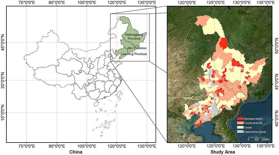
Figure 1. Location of the study area.
Similar to other underdeveloped regions, the primary land utilization types in Northeast China are forested land and cultivated land, which account for 45.34% and 39.74% of the total land area, respectively (Liu et al., 2014). With the advancement of urbanization, the expansion of urban construction continues to encroach upon forest and cultivated lands (Brend’Amour et al., 2016). While the Northeast China remain major agricultural provinces, they are consistently facing population decline, which results in the underutilization of vast amounts of land. While Northeast China remains a major agricultural region, it is consistently facing population decline, which results in the underutilization of vast amounts of land. However, despite existing studies addressing the context of de-industrialization, in-depth research on the dynamic changes in land use efficiency, population migration, and human-land relationships in Northeast China—especially at the county scale—remains scarce. Therefore, this study selects the three northeastern provinces as the research area, aiming to explore the underlying causes of issues such as low land use efficiency and population loss, providing theoretical support for improving land use patterns in the region, alleviating population decline, and offering empirical evidence for regional sustainable development.
2.2 Data sources
The population data for 2000 and 2020 were obtained from the county-level statistical yearbooks of the Fifth and Seventh Censuses, respectively. For districts and counties with administrative changes, the 2020 administrative divisions were used, and the 2000 population data were recalculated according to the 2020 administrative divisions, with reference to township-level statistical yearbooks for accuracy.
The data on urban-rural construction land in 2000 and 2020 are derived from the dataset of Chinese Comprehensive National Land Utilization and Cover Change (CNLUCC), which is based on Landsat satellite imagery as the primary information source, was constructed through manual visual interpretation to create a multi-period national-scale land utilization/land cover thematic database for China. This study uses 30-m resolution raster data, which is classified by a two-level classification system. The first-level includes six categories: cultivated land, forest land, grassland, water land, construction land and unused land, and the second-level classification is further divided into 25 types.
2.3 Dynamic land utilization efficiency index and corresponding models
Reasonable adjustment of per capita residential land area (Pcrla) is one of the most effective methods for improving land utilization efficiency (Xiang et al., 2023). Among these, determining the ideal urban-rural land utilization level is the key challenge. It represents a land utilization level that aligns with the regional land resource endowment and a specific socio-economic and technological development level. This study employs a reasonable dynamic land utilization efficiency evaluation model (Xiang et al., 2023). The planned land-utilization level should be comprehensively determined according to the current land-utilization level, the climate zone where it is located, and the planned population size, which should meet the two-factor restriction requirements of the allowable planned land utilization level and adjustment range at the same time (Wang et al., 2012). The new edition of the Code for Classification of urban land use and planning standards of development land has improved many of the above-mentioned aspects, so the planned land level specified in the standard can be regarded as the ideal urban-rural land level. This standard can also be regarded as the ideal value of Pcrla. Additionally, the calculation formula of the dynamic land utilization efficiency index is defined, with six land utilization modes classified and identified based on the value range of calculated results. Finally, to compare the dynamic land utilization efficiency index with the traditional coupling coordination index, the calculation results of this index are also obtained.
2.3.1 Selection of ideal value of Pcrla
The new edition of the Code for classification of urban land use and planning standards of development land has been revised by summarizing the problems and experiences in the implementation of the original standard. Therefore, the planned land utilization level specified in the standard can be deemed as the ideal urban-rural land utilization level. The ideal value of urban-rural construction land per capita mainly refers to the new edition of the Code for classification of urban land use and planning Standards of development land and planning standards of village and town, with
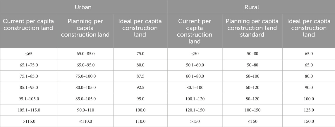
Table 1. Ideal value of urban-rural construction land per capita.
The judgment of urban-rural areas is determined by the
Due to the different urbanization of different cities, according to the ratio of the districts with the lowest ratio in the municipal districts of this city, counties and districts less than this ratio are classified as rural types, while those greater than this ratio are classified as urban types. On this basis, according to different types of
2.3.2 Definition of dynamic land utilization efficiency index and corresponding six patterns of recognition
Dynamic land utilization efficiency index (
where
Given that the calculation results of
Principle 1:. Construction land can be moderately increased in districts and counties with net population inflow, while the actual value of Pcrla of net population growth should not exceed the current ideal value.
Principle 2:. In districts and counties with net population outflow, the construction land should be reduced, and the area of each net population outflow reduction should not be lower than
Any situation that meets both of the above principles is considered intensive. Otherwise, it is non-intensive. Therefore, dynamic land utilization patterns can be classified into six categories, as defined in Equation 5, in which the indicator
Specifically:
① Based on Principle 1, when the population inflow is accompanied by rural residential land expansion,
② Based on Principle 2, when the population outflow is accompanied by rural residential land expansion,
③ Based on Principle 2, when the population outflow is accompanied by rural residential land shrinkage,
④ Based on Principle 1, when the population inflow is accompanied by rural residential land shrinkage,
2.4 Statistics of Getis-Ord Gi*
To quantify the spatial dependence of human-computer interaction, the Getis-Ord Gi* statistical model was adopted to determine the clustering level of population and urban-rural residential land. The formula is defined in Equations 6, 7 (Singh et al., 2021):
where
Through the Getis-Ord Gi* statistics, clustering patterns and random patterns can be identified separately. The Getis-Ord Gi* statistical results for each district-county were calculated values of z-score (standard deviation) and p-value (independent probability), both of which were used to estimate the statistical significance of spatial auto-correlation.
2.5 Driving mechanism of urban-rural human-land interaction
To further explore the relationship between population mobility and urban-rural construction land, this paper uses the Kaya identity to establish a model of driving force factors, with LMDI used to quantitatively analyze the influence of different driving force factors. Because some districts and counties are in a state of population loss and others are in a state of population inflow, the influence of driving force factors in different states may vary. Therefore, the districts and counties in the study area are divided into two categories, including net population outflow and net population inflow, with their driving mechanisms explored respectively.
2.5.1 Kaya identity
The Kaya identity was first proposed by Kaya in 1989 at the Intergovernmental Panel on Climate Change (IPCC). It is commonly used to quantify the total greenhouse gas emissions (in CO2 equivalent) resulting from anthropogenic activities (Kaya, 1989; Piwowar, 2019; Yamaji et al., 1993; You et al., 2023). It also can be used to detect the driving forces of rural residential area changes under urbanization effects (Shi and Wang, 2021). In this paper, the driving force factors are decomposed into land utilization efficiency factor (
where
2.5.2 LMDI
Since 2000, the most popular method of exponential decomposition analysis has been the LMDI (Ang., 2015). As a renowned decomposition technique, the LMDI was initially used to quantify the impact of energy expenditure, with the practical advantage of providing a perfect decomposition without residuals (Wang et al., 2014). The driving forces in the Kaya identity are disaggregated as presented in Equations 9-13:
where
For districts and counties with net population inflow and those with net population outflow, the corresponding index is calculated, respectively:
For districts and counties with net population inflow,
The calculation results of each driving force factor are positive, which indicates that it promotes the increase of urban-rural construction land. Negative results indicate that it inhibits the increase of urban-rural construction land.
3 Results and analysis
3.1 Quantitative characteristics and spatial distribution of urban-rural human-land interaction in urbanization
The types of changes in human-land action are divided into four categories, with hotspot analysis used to test the statistical significance of the changes (Figure 2). From the perspective of human-land changes from 2000 to 2020, the interaction between urban-rural human-land in Northeast China is dominated by population outflow accompanied by construction land expansion (POLE), accounting for 57.7%. Population inflow accompanied by construction land expansion (PILE) accounts for 27.8%. Meanwhile, population outflow accompanied by construction land shrinkage (POLS) is less, accounting for 12.8%, of which only 1.4% is population inflow accompanied by construction land shrinkage (PILS). PILS as the type of human-land interaction accounted for the least proportion in 20 years, and POLE accounted for the largest proportion in 20 years. From the perspective of spatial distribution characteristics, POLE is basically distributed in Northeast China, while POLS is mainly distributed in the central and eastern Heilongjiang Province as well as the central Jilin Province and Liaoning Province. PILE is mainly distributed on both sides of POLS. PILS mainly distributed in the southeastern Heilongjiang Province.
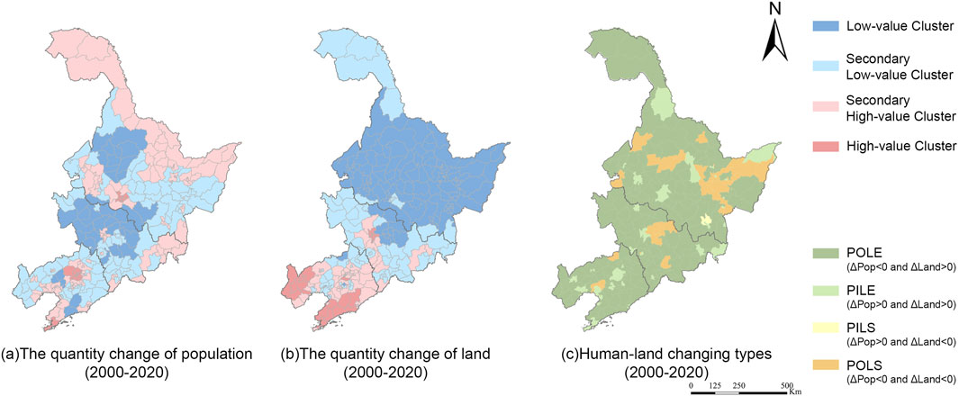
Figure 2. The quantity changes of population (a), the quantity change of land (b), human-land changing types (c) (2000–2020).
According to the results of Getis-Ord Gi*, the clusters are divided into low cluster, second-lowest cluster, second-highest cluster, and high cluster by natural breakpoint. Regarding population changes, according to Figures 2a,b from 2000 to 2020, the Northeast China were dominated by population loss. However, the northernmost area, Harbin, Shenyang and Dalian, showed the second-highest population and high cluster zone. Two low cluster centers are formed around Heihe, Qiqihar, Suihua and Changchun North, Songyuan and Siping, which is in line with the characteristics of provincial capitals and coastal cities with an agglomeration effect. In the past 20 years, although the population gathered in northern Heilongjiang and near Harbin, the construction scale decreased instead, while Jilin Province showed apparent low population clustering. The central and southern Heilongjiang Province almost completely shows a low cluster, and the urban-rural residential land shrinks, while the opposite is found in Liaoning Province. It proves that the development and construction intensity in the south of Northeast China is stronger, but less in the north. Based on the above results, it is proven that there are apparent characteristics of disharmony between human-land during the urbanization in Northeast China.
3.2 Dynamic land utilization efficiency and pattern recognition
Based on Equation 4, the dynamic land utilization efficiency index is calculated, which allows for the identification and classification of dynamic land utilization types (Figure 3). After subdividing the six types, the number of six dynamic land utilization patterns in different municipalities is summarized by taking the municipal administrative district as the basic statistical unit. Then, to better visualize the spatial distribution law, the data at the municipal level of each type are classified. Meanwhile, the units with high value and specific units are marked to represent the number of districts and counties of a certain type in each municipal unit.
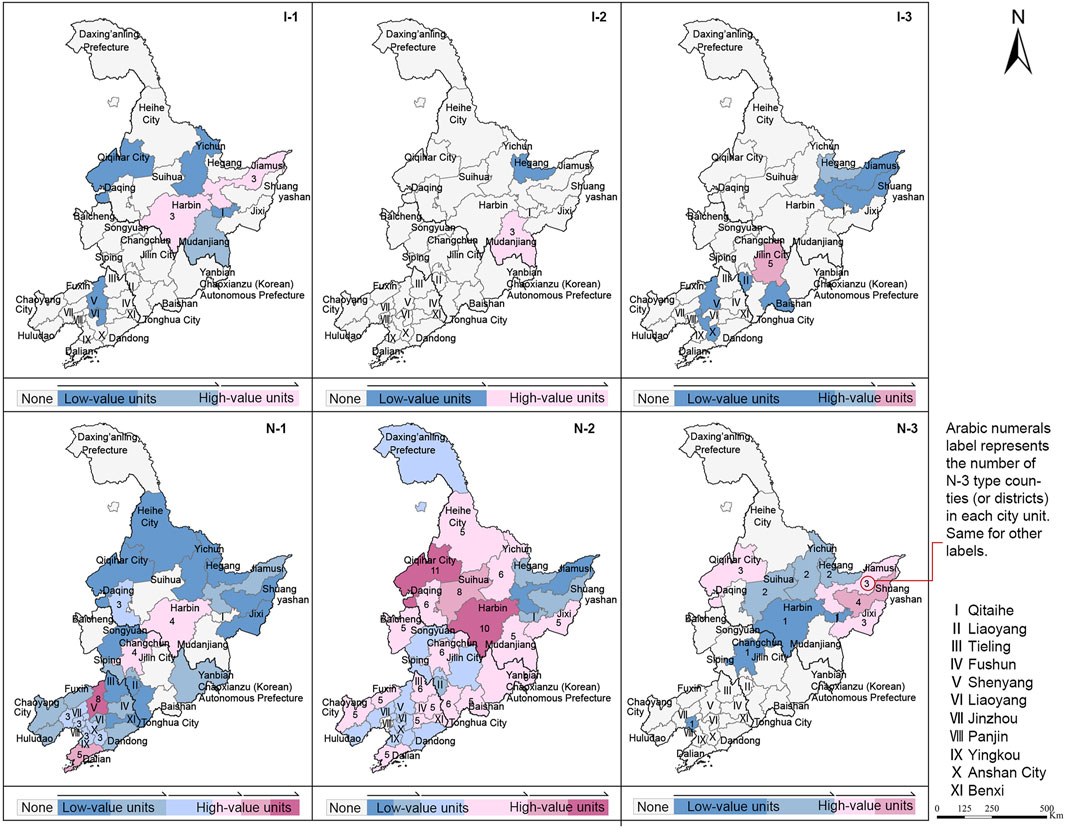
Figure 3. Spatial distribution of six types of dynamic land utilization patterns (2000–2020).
From 2000 to 2020, the types of districts and counties in the Northeast China were mainly non-intensive and less intensive, accounting for 89% and 11%, respectively. Among the non-intensive types, the N-2 type accounting for 64.8%. During these 20 years, Jilin, Harbin and Qiqihar are areas of population outflow with high values, while Shenyang and Dalian are areas of population inflow with high values. Harbin, Changchun, Shenyang and Dalian are areas with high values for construction land expansion. However, Shuangyashan and its surrounding areas, Jilin City and Mudanjiang City, are areas with high values for construction land shrinking. Both N-1 and N-2 belong to construction land expansion, regardless of population inflow or population outflow.
In terms of the spatial distribution of six types of dynamic land utilization patterns (Figure 3), Harbin has the most N-1 type of districts and counties, with population inflows accompanying the expansion of construction land. Daqing, Qiqihar, and Suihua have more N-2 type districts and counties with population outflow, but the area of construction land is expanding, which indicates an imbalance between land utilization and population dynamics. The I-1 type districts and counties start from Jiamusi and are distributed along the northeast to southwest direction. Mudanjiang has a large number of I-2 type districts and counties, while Jixi has a distinct I-3 characteristics, showing a shrinking situation of population outflow and decreasing construction land. It is inferred that the population inflows from Jixi to Mudanjiang, but urban-rural construction land did not grow in parallel, with land changes are lagging behind the population changes.
3.3 Characteristics of type transition of urban-rural construction land
The first to propose the concept of land utilization transition was a British scholar, who pointed out that land utilization transition is a dynamic process that changes with socio-economic development (Gong et al., 2023). The dynamic land utilization pattern from 2000 to 2020 was dominated by N-2, and most cities experienced a decrease in population with the expansion of construction land. Provincial capital cities and coastal cities are mainly N-2, most of which are transferred from paddy fields and dry land to urban-rural construction land. Some of them are transferred from forest and grass land. I-2-type cities (represented by Mudanjiang) have witnessed a decrease in urban-rural construction land, but their population has increased. Some urban-rural construction land has been transferred into other construction land for mining, factories and transportation, which may attract population due to industrial and infrastructure development (Figure 4). Both N-3 and I-3 are accompanied by population loss. It can be seen from the figure that in addition to cultivated land, part of N-3 is transferred into the reservoir, and part of I-3 is transferred into woodland, except most of the land is transferred into dry land. For cities where construction land is expanding, paddy fields and dry land are still mainly transferred. The whole is also characterized by some transitions from forest and grass land. In cities where the reduction of urban-rural construction land is the primary trend, the land utilization types being transferred out are predominantly paddy fields (mainly used for growing rice and other aquatic crops) or dry land (mainly used for vegetable cultivation), indicating an overall trend of land being returned to agriculture.
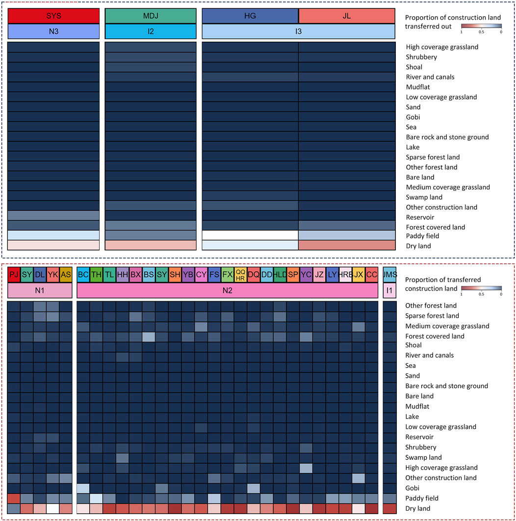
Figure 4. Transfer of urban-rural construction land types (2000–2020).
3.4 Driving mechanism of urban-rural human-land interaction under Kaya-LMDI model
According to various population mobility patterns, the Northeast China, districts and counties are divided into 83 districts and counties with net population inflow and 198 districts and counties with net population outflow. The driving force factors of the two groups of data were quantitatively calculated, respectively. For districts and counties with
3.4.1 Analysis of district and county’s driving mechanism of net population inflow
3.4.1.1 Districts and counties with
Among the 83 districts and counties with net population inflow, most districts and counties belong to N-2 and N-1 dynamic land utilization patterns. There are 72 districts and counties with positive
3.4.1.2 Districts and counties with
Among the districts with
3.4.2 Analysis of district and county’s driving mechanism of net population outflow
3.4.2.1 Districts and counties with
Among the 198 districts and counties with net population outflow, there are 162 districts and counties with positive
3.4.2.2 Districts and counties with
Among the districts and counties with a decrease in the area of urban-rural construction land, 68.6% were primarily affected by demographic structure factors (
3.4.3 Comparative analysis
In districts and counties with net population inflows, urban-rural construction land expansion is primarily driven by an increase in the inflow of population, while land reduction is mainly due to a decline in the proportion of the permanent population. In districts and counties with net population outflows, construction land expansion occurs mainly when the proportion of out-migrants increases, while land reduction is primarily due to a decrease in the resident population proportion. Among the districts and counties with net population inflow, there is no increase in land utilization efficiency in districts and counties (
4 Discussion
4.1 Different characteristics of urban-rural construction land transition
For cities characterized by different dynamic land utilization patterns, the change in urban-rural construction land may be caused by different reasons. For provincial capital cities and coastal cities, the predominant type is N-2. Although the population continues to lose, to attract population or urban development, urban-rural construction land will continue to expand. Some may occupy ecological spaces such as forest and grass land. In addition, some other construction land has been transferred to urban-rural construction land. Combined with the 16-year supply-side structural reform in Northeast China, traditional industries such as coal and steel have been removed, and new industries have been developed, which may give rise to an increase in urban-rural construction land.
De-industrialization is not only the result of economic restructuring but also a process driven by the dual mechanisms of resource extrusion and declining cost competitiveness. This mechanism has prompted many cities to repurpose construction land that was once dependent on heavy industry to adapt to new economic structures and social demands. Similar to other regions in China, the de-industrialization process in Northeast China differs in some respects from the traditional service sector transformation model. Existing studies have shown that de-industrialization is not merely the result of industrial structural transformation, but is also profoundly influenced by policy interventions and regional resource endowments (Chen, 2024; Ren et al., 2020). However, during the de-industrialization process in Northeast China, some cities face significant challenges in their transformation, such as the lack of sufficient technical support and policy guidance (Wang et al., 2018). Compared to de-industrialized cities such as Detroit, Cleveland, and Pittsburgh in the United States, where industrial land conversion has been relatively efficient, particularly with strong land use performance in service and management sectors (Han et al., 2024). However, in Northeast China, some cities have seen urban-rural construction land converted into forested land, grassland, or mining-industrial land, which may be attributed to differences in functional roles among cities. For example, in Jilin City, the majority of land has been converted into dry land, with some areas transformed into forested land. This shift is likely related to the region’s prominent agricultural and forestry advantages, which may drive the development of high-standard agricultural and forestry economies. In cities where substantial urban construction land has been converted into cultivated land, this trend may stem from the advantages of land resources and higher levels of agricultural mechanization, leading to a prioritization of agricultural production and the full utilization of regional strengths. The study indicates that Liaoning Province has the most significant expansion of urban-rural construction land. Jilin Province shows a noticeable trend of construction land being repurposed for other uses at the county level. While Heilongjiang Province faces severe population decline and urgently needs to attract more residents. These shifts align with the specific provincial policies under the Northeast Area Revitalization Plan. Liaoning Province focuses on innovation and entrepreneurship and the development of functional zones. Heilongjiang Province focuses on opening-up policy, state-owned enterprise policy and government reform strategy. Jilin Province emphasis on infrastructure construction and social security policies aligns with its provincial context (https://www.gov.cn). In China, land utilization research started late, but the research field is wider with a higher degree of integration with policy research (Lei et al., 2023).
Furthermore, the long-term impacts of urban and rural construction land conversion deserve attention. Underdeveloped cities in Northeast China, such as some prefecture-level cities in Heilongjiang Province, have experienced weakened land development demand due to issues like a single industrial structure and continuous population outflow, leading to a reduction in the scale of urban and rural construction land. For example, in resource-based cities like Hegang and Shuangyashan, after the decline of the coal industry, some industrial land has been converted into agricultural or ecological restoration land to alleviate the economic pressure caused by resource depletion. Although some regions have shifted toward agricultural production to improve land use efficiency, if agricultural modernization fails to keep pace, land use efficiency may still be constrained. Future policies should further promote industrial upgrading to enhance the long-term sustainability of land use.
4.2 Relationship between population mobility and land utilization efficiency
In the Northeast China, 40.9% of districts and counties experiencing either net population inflows or outflows have seen a decline in land utilization efficiency. However, all the districts and counties with net population inflow showed a decline in land utilization efficiency, which was more pronounced than in the districts and counties with net population outflow. It is worth noting that the decline in land utilization efficiency in areas with net inflow was more significant than in those with net outflow, suggesting that population inflow has not effectively driven an improvement in land utilization efficiency. However, all the districts and counties with net inflow showed a decline in land utilization efficiency, which was more apparent than the districts and counties with net population outflow. During the process of de-industrialization, many traditional industrial cities have experienced a decline in urban and rural construction land due to industrial recession and population loss, which has directly led to a decrease in land use efficiency. This phenomenon contradicts the traditional theory that ‘population inflow inevitably improves land utilization efficiency,’ indicating that in Northeast China, land function reconfiguration, rather than industrial substitution, is more effective in improving land utilization efficiency. For example, some land has been converted from construction land to farmland, leveraging agricultural mechanization and land resource advantages. This de-industrialization model is more adaptable and effective than the development of the service sector. Compared to the de-industrialization model in the southeastern coastal regions, which is led by industrial upgrading, the less-developed northeastern regions rely more on the reallocation of land resources and agricultural development, and this model has positively contributed to the improvement of land utilization efficiency. In this process, cities experiencing population inflow but a reduction in construction land, attract seasonal migrant workers due to agricultural development, but most of them will not become registered residents. The low percentage of registered residents makes developers not to develop and build more. This finding coincides with the optimization path of moderately weakening the relationship between construction land growth and agricultural migration population in other studies, which can improve the functionality and utilization efficiency of construction land driven by population migration (Wang et al., 2022). On the other hand, as urbanization accelerates, the share of rural industry in GDP has further decreased (Chen et al., 2014), resulting in limited population inflows in rural areas. Therefore, optimizing land use efficiency solely through population inflows is unrealistic. The efficiency improvement is more reliant on controlling the scale of rural homesteads than on population influx. Consequently, future policies should focus on enhancing the sustainability of agricultural land use in cities with low household registration populations, using tools such as fiscal subsidies, technical support, and promoting regional economic diversification.
4.3 Limitations
This study explores the impact of population mobility on land use efficiency by analyzing population movement and urban-rural construction land changes in Northeast China between 2000 and 2020. However, there are certain limitations in the study. First, due to administrative adjustments in some districts and counties, data based on the 2020 administrative divisions were used, and population numbers were estimated using township-level statistical yearbooks. While this approach helps improve data consistency, it may affect the accuracy of some districts and counties. Future research should address administrative division changes with greater precision. Second, the interpretation accuracy and consistency of the CNLUCC dataset remain limited, with manual interpretation of Landsat imagery potentially introducing biases. Future studies could utilize higher resolution data or automated interpretation techniques to enhance data precision. Furthermore, while the data in this study reflect factors such as population change, land development intensity, and urban expansion, socio-economic variables, policy regulations, and natural resource constraints may not have been fully considered, which could affect a comprehensive assessment of land use efficiency.
5 Conclusion
Based on data from Northeast China between 2000 and 2020, the complex relationships between population migration, urban-rural construction land changes, and land use efficiency in traditional industrial cities are revealed. Most districts and counties in the region exhibit an N-2 pattern (increased urban-rural construction land and declining population), which is primarily driven by population loss and the increase in permanent residents. The expansion of urban-rural construction land is often aimed at attracting population or supporting industries such as agriculture and forestry. Many cities have seen construction land converted into cultivated land and forested areas, reflecting changes in urban functions and land use patterns under the de-industrialization process. Although population migration has a significant impact on urban-rural construction land changes, population inflows do not necessarily enhance land use efficiency and may, in fact, lead to resource inefficiencies. Future research should focus on optimizing land management policies, balancing population migration with land use efficiency, particularly in the context of de-industrialization, and exploring how to achieve coordinated development between agriculture and the service sector, while promoting integrated land resource utilization. This is crucial for driving urban transformation, improving land use efficiency, and achieving sustainable development goals. Policies should be tailored to the economic and social contexts of different regions, especially the unique needs of resource-dependent areas, by formulating differentiated land use and industrial policies to facilitate the effective transformation of regional economic structures and ensure the long-term sustainability of land use.
Data availability statement
The raw data supporting the conclusions of this article will be made available by the authors, without undue reservation.
Author contributions
XK: Conceptualization, Writing – review and editing. YW: Data curation, Formal Analysis, Resources, Validation, Writing – original draft. PC: Conceptualization, Funding acquisition, Project administration, Supervision, Writing – review and editing. YS: Data curation, Formal Analysis, Resources, Validation, Writing – original draft. GW: Methodology, Writing – review and editing.
Funding
The author(s) declare that financial support was received for the research and/or publication of this article. Natural Science Foundation of Heilongjiang Province of China, grant number YQ2023E003; Fundamental Research Funds for the Central Universities, grant number 2572023CT18-06.
Conflict of interest
The authors declare that the research was conducted in the absence of any commercial or financial relationships that could be construed as a potential conflict of interest.
Generative AI statement
The author(s) declare that no Generative AI was used in the creation of this manuscript.
Publisher’s note
All claims expressed in this article are solely those of the authors and do not necessarily represent those of their affiliated organizations, or those of the publisher, the editors and the reviewers. Any product that may be evaluated in this article, or claim that may be made by its manufacturer, is not guaranteed or endorsed by the publisher.
References
Ang, B. W. (2015). LMDI decomposition approach: a guide for implementation. Energy Policy 86, 233–238. doi:10.1016/j.enpol.2015.07.007
Azhdari, A., Sasani, M. A., and Soltani, A. (2018). Exploring the relationship between spatial driving forces of urban expansion and socioeconomic segregation: the case of Shiraz. Habitat Int. 81, 33–44. doi:10.1016/j.habitatint.2018.09.001
Brend’Amour, C., Reitsma, F., Baiocchi, G., Barthel, S., Güneralp, B., Erb, K., et al. (2016). Future urban land expansion and implications for global croplands. Proc. Natl. Acad. Sci. U. S. A. 114 (34), 8939–8944. doi:10.1073/pnas.1606036114
Chaolin, G. U., Liya, W. U., and Cook, I. (2012). Progress in research on Chinese urbanization. Front. Archit. Res. 1 (2), 101–149. doi:10.1016/j.foar.2012.02.013
Chen, K., Long, H., Liao, L., Tu, S., Li, T., Díaz-Palacios-Sisternes, S., et al. (2014). A method for detecting and describing land use transformations: AN examination of Madrid’s southern urban-rural gradient between 1990 and 2006. Land Use Policy 40, 104465. doi:10.1016/j.cities.2014.03.010
Chen, Y. (2024). Regional decline and structural changes in Northeast China: an exploratory space–time approach. Asia-Pacific J. Regional Sci. 8 (2), 397–427. doi:10.1007/s41685-023-00328-0
Dewan, A. M., and Yamaguchi, Y. (2009). Land use and land cover change in Greater Dhaka, Bangladesh: using remote sensing to promote sustainable urbanization. Appl. Geogr. 29 (3), 390–401. doi:10.1016/j.apgeog.2008.12.005
Gong, Y., You, G., Chen, T., Wang, L., and Hu, Y. (2023). Rural landscape change: the driving forces of land use transformation from 1980 to 2020 in Southern Henan, China. Sustainability 15 (3), 2565. doi:10.3390/su15032565
Han, Z., Xie, W., Yu, H., Xie, H., Li, Y., and Wang, Y. (2024). Rethinking industrial land-use in American rust cities towards sustainability based on a block-level model. J. Environ. Manag. 352, 120067. doi:10.1016/j.jenvman.2024.120067
Jiang, G., He, X., Qu, Y., Zhang, R., and Meng, Y. (2016). Functional evolution of rural housing land: a comparative analysis across four typical areas representing different stages of industrialization in China. Land Use Policy 57, 645–654. doi:10.1016/j.landusepol.2016.06.037
Jiang, Y., Chen, Z., and Sun, P. (2022). Urban shrinkage and urban vitality correlation research in the three northeastern provinces of China. Int. J. Environ. Res. Public Health 19 (17), 10650. doi:10.3390/ijerph191710650
Kaya, Y. (1989). Impact of carbon dioxide emission control on GNP growth: interpretation of proposed scenarios. Geneva, Switzerland: Intergovernmental Panel on Climate Change/Response Strategies Working Group.
Lei, Y., Dong, Z., Dong, J., and Dong, Z. (2023). Multidimensional evaluation of urban land-use efficiency and innovation capability analysis: a case study in the Pearl River Delta region, China. Sustainability 15 (8), 6387. doi:10.3390/su15086387
Li, C., Wu, K., and Gao, X. (2020). Manufacturing industry agglomeration and spatial clustering: evidence from Hebei Province, China. Environ. Dev. Sustain. 22 (4), 2941–2965. doi:10.1007/s10668-019-00328-1
Li, S., An, W., Zhang, J., Gan, M., Wang, K., Ding, L., et al. (2023). Optimizing limit lines in urban-rural transitional areas: unveiling the spatial dynamics of trade-offs and synergies among land use functions. Habitat Int. 140, 102907. doi:10.1016/j.habitatint.2023.102907
Lin, B., and Zhu, J. (2021). Impact of China’s new-type urbanization on energy intensity: a city-level analysis. Energy Econ. 99, 105292. doi:10.1016/j.eneco.2021.105292
Liu, S., Zhang, P., and Lo, K. (2014). Urbanization in remote areas: a case study of the Heilongjiang reclamation area, Northeast China. Habitat Int. 42, 103–110. doi:10.1016/j.habitatint.2013.11.003
Luo, J., Zhang, X., Wu, Y., Shen, J., Shen, L., and Xing, X. (2018). Urban land expansion and the floating population in China: for production or for living? Cities 74, 219–228. doi:10.1016/j.cities.2017.12.007
Ma, M., Liu, Y., Wang, B., Yan, X., and Li, H. (2023). Spatial-temporal evolution and driving mechanism of urban land use efficiency based on T-DEA model: a case study of Anhui province, China. Sustainability 15 (13), 10087. doi:10.3390/su151310087
Mahtta, R., Fragkias, M., Güneralp, B., Mahendra, A., Reba, M., Wentz, E. A., et al. (2022). Urban land expansion: the role of population and economic growth for 300+ cities. NPJ Urban Sustain. 2 (1), 5. doi:10.1038/s42949-022-00048-y
Niftiyev, I. (2020). Dutch disease symptoms in Azerbaijan economy. J. Econ. Coop. Dev. 41 (3), 33–67.
Niftiyev, I. (2025). Unveiling the Dutch disease indexes: principal component analysis in a small oil-rich country. Periodica Polytech. Soc. Manag. Sci. 33 (1), 1–13. doi:10.3311/ppso.22914
Peng, Q., Wu, D., Lin, W., Fan, S., and Su, K. (2024). Land-use transitions and its driving mechanism analysis in putian city, China, during 2000-2020. Sustainability 16 (9), 3549. doi:10.3390/su16093549
Piwowar, A. (2019). Low-carbon agriculture in Poland: theoretical and practical challenges. Pol. J. Environ. Stud. 28 (4), 2785–2792. doi:10.15244/pjoes/92211
Ren, W., Xue, B., Yang, J., and Lu, C. (2020). Effects of the Northeast China revitalization strategy on regional economic growth and social development. Chin. Geogr. Sci. 30, 791–809. doi:10.1007/s11769-020-1149-5
Seto, K. C., Fragkias, M., Güneralp, B., and Reilly, M. K. (2011). A meta-analysis of global urban land expansion. PloS One, 6 (8), e23777. doi:10.1371/journal.pone.0023777
Shi, L., and Wang, Y. (2021). Evolution characteristics and driving factors of negative decoupled rural residential land and resident population in the Yellow River Basin. Land Use Policy 109, 105685. doi:10.1016/j.landusepol.2021.105685
Shi, W., Tian, J., Namaiti, A., and Xing, X. (2022). Spatial-temporal evolution and driving factors of the Coupling Coordination between urbanization and urban resilience: a case study of the 167 counties in Hebei province. Int. J. Environ. Res. Public Health 19 (20), 13128. doi:10.3390/ijerph192013128
Singh, P. P., Sabnani, C. S., and Kapse, V. S. (2021). Hotspot analysis of structure fires in urban agglomeration: a case of Nagpur City, India. Fire 4 (3), 38. doi:10.3390/fire4030038
Smailes, P. J., Argent, N., and Griffin, T. L. (2002). Rural population density: its impact on social and demographic aspects of rural communities. J. Rural Stud. 18 (4), 385–404. doi:10.1016/s0743-0167(02)00033-5
Sun, P., and Wang, K. (2021). Identification and stage division of urban shrinkage in the three provinces of Northeast China. Acta Geogr. Sin. 76 (6), 1366–1379. doi:10.11821/dlxb202106004
Taubenböck, H., Wegmann, M., Roth, A., Mehl, H., and Dech, S. (2009). Urbanization in India—spatiotemporal analysis using remote sensing data. Comput. Environ. Urban Syst. 33 (3), 179–188. doi:10.1016/j.compenvurbsys.2008.09.003
Wang, B., Tian, J., and Wang, S. (2022). Process and mechanism of transition in regional land use function guided by policy: a case study from Northeast China. Ecol. Indic. 144, 109527. doi:10.1016/j.ecolind.2022
Wang, H., Chen, T., and Ma, H. (2018). Different institutions, distinctive trajectories? Revisiting maritime industrial development areas with cases on China’s liaoning coast. Growth Change 49 (1), 165–188. doi:10.1111/grow.12230
Wang, J., Zhao, M., and Li, X. (2012). Discussion on the formulation of new standards for planning and construction land in China. City Plan. Rev. (4), 54–60.
Wang, W., Liu, X., Zhang, M., and Song, X. (2014). Using a new generalized LMDI (logarithmic mean Divisia index) method to analyze China’s energy consumption. Energy 67, 617–622. doi:10.1016/j.energy.2013.12.064
Wu, Y. (2010). The review and reflection of China’s urbanization—the prospective exploration of post-industrialization economic pilot district. China Ind. Econ. 10, 5–14. doi:10.19581/j.cnki.ciejournal.2010.10.001
Xiang, S., Zhou, M., Huang, L., Shan, L., and Wang, K. (2023). Assessing the dynamic land utilization efficiency and relevant driving mechanism in in-situ urbanized rural areas: A case study of 1979 administrative villages in Hangzhou. Environ. Impact. Assess. Rev. 101, 107111. doi:10.1016/j.eiar.2023.107111
Xiang, S., Huang, L., Zhou, M., Shan, L., Dong, B., and Wang, K. (2023). Dynamic analysis of correlation patterns between urban population and construction land at different administrative levels: the case of Hangzhou megacity. Ecol. Indic. 154, 110407. doi:10.1016/j.ecolind.2023.110407
Yamaji, K., Matsuhashi, R., Nagata, Y., and Kaya, Y. (1993). A study on economic measures for CO2 reduction in Japan. Energy Policy 21 (2), 123–132. doi:10.1016/0301-4215(93)90134-2
You, K., Chen, L., and Huang, R. (2023). The estimation of carbon imbalance and driving factors in China's urban residential building sector. Urban Clim. 49, 101571. doi:10.1016/j.uclim.2023.101571
Yu, S., Zhang, Z., Liu, F., Wang, X., and Hu, S. (2019). Assessing interannual urbanization of China’s six megacities since 2000. Remote Sens. 11 (18), 2138. doi:10.3390/rs11182138
Keywords: human-land coupling, dynamic land utilization efficiency, traditional industrial city, LMDI, urbanization
Citation: Kong X, Wu Y, Cui P, Sun Y and Wei G (2025) Dynamic land use efficiency and human-land relationship in traditional industrial cities. Front. Environ. Sci. 13:1546213. doi: 10.3389/fenvs.2025.1546213
Received: 16 December 2024; Accepted: 30 April 2025;
Published: 15 May 2025.
Edited by:
John McCaskill, The University of Texas at Dallas, United StatesReviewed by:
Maksymilian Solarski, University of Silesia in Katowice, PolandIbrahim Niftiyev, Azerbaijan State University of Economics, Azerbaijan
Md Eyasin Ul Islam Pavel, The University of Texas at Dallas, United States
Copyright © 2025 Kong, Wu, Cui, Sun and Wei. This is an open-access article distributed under the terms of the Creative Commons Attribution License (CC BY). The use, distribution or reproduction in other forums is permitted, provided the original author(s) and the copyright owner(s) are credited and that the original publication in this journal is cited, in accordance with accepted academic practice. No use, distribution or reproduction is permitted which does not comply with these terms.
*Correspondence: Peng Cui, Y3VpcGVuZ0BuZWZ1LmVkdS5jbg==
†These authors have contributed equally to this work and share first authorship