Abstract
Introduction:
Estimation of forest carbon (C) storage is essential for understanding the global C cycle, mitigating climate change, and developing carbon markets. However, systematic research on forest C storage estimation needs improving.
Methods:
Herein, a bibliometric and content review of literature published between 2008 and 2025 was conducted to synthesize temporal and spatial trends and to identify methodological advances and gaps in forest C-storage estimation.
Results:
The results revealed that environmental sciences accounted for the largest share of publications (n = 718). The most productive institution and country were the Chinese Academy of Sciences (n = 208) and the United States (n = 691), respectively. Research progress in the field was categorized into three distinct stages since 2008. The early stage (2008–2012) was dominated by eddy covariance, satellite remote sensing, and airborne radar. The middle stage (2013–2017) was characterized by greater use of process-based and statistical simulation models. In the later stage (2018–2025), techniques such as random forest (RF), machine learning and biomass mapping became more widely used. Over this period, model performance improved substantially, especially the coefficient of determination (R2) increased from 0.62 to 0.97 for the TRIPLEX-Flux C-exchange model and from 0.63 to 0.97 for RF models.
Discussion:
Spatially, most studies addressed local-to-regional scales, whereas large-scale or global assessments remain limited. This synthesis clarifies methodological trajectories and persistent gaps that can guide the development and wider deployment of forest C-storage estimation approaches and support evidence-based climate policy and C-market design.
1 Introduction
Forests cover a substantial portion of the Earth’s surface (Berner and Goetz, 2022; Köhl et al., 2015). The changes in their carbon (C) storage directly affect atmospheric carbon dioxide concentrations (Hao et al., 2025), and, in turn, the stability of the global climate system (Stancliffe et al., 2024). Accordingly, robust estimation of forest C storage is crucial for understanding and regulating the climate system (Lázaro-Lobo et al., 2023; Xu K. et al., 2025). Accurate estimates not only inform assessments of the global C balance but also underpin effective forest management and conservation policies (Liu et al., 2023; Green and Keenan, 2022) and provide reliable data to support C trading and climate policymaking (Intergovernmental Panel on Climate Change (IPCC), 2019; Fahey et al., 2010). As global forest area continues to decline due to deforestation and land degradation, the need for effective and scalable approaches to estimating forest C storage has become increasingly urgent (Bossy et al., 2025; Yang H. et al., 2023).
Common approaches include ground measurements, allometric/biomass equations, and remote sensing (RS) techniques (Rodríguez-Veiga et al., 2017). Ground measurements, based on plot-level surveys of tree height, diameter at breast height (DBH), and species composition, yield high accuracy but are time- and labor-intensive, limiting their feasibility over large or complex terrains (Xu et al., 2010). Biomass-equation methods use statistical relationships between measurable tree attributes and biomass/C stock (Yang M. et al., 2023). These techniques are cost-effective and operationally simple, whereas their accuracy depends on model transferability and region-specific parameters. By contrast, advances in RS (particularly satellite-based observations) have catalyzed rapid growth in large-area forest C-storage estimation (Mo et al., 2023; Ye et al., 2022).
The RS landscape has evolved from single-source imagery and qualitative analyses to multi-source data integration and quantitative inversion (Zhang, 2010). Early efforts relied on medium- to low-resolution sensors (e.g., Landsat TM, 30 m) and vegetation indices such as Normalized Differnce Vegetation Index (NDVI) to approximate productivity (Zhao, 2007). However, spatial resolution limited the precise mapping of C-pool distributions (Goetz et al., 2009). In the early 21st century, progress in hyperspectral RS (e.g., Hyperion) and sub-meter resolution satellites (e.g., Gaofen series) enabled the coupling of chlorophyll-fluorescence proxies with multispectral band combinations, significantly improving biomass inversion for ecosystems such as mangroves More recently, satellite constellations (e.g., Jilin-1) have approached daily global coverage. Coupled with AI-enabled image interpretation, update cycles for C-flux monitoring have accelerated from interannual to quarterly.
These advances have shifted C mapping from static inventories to spatiotemporal, multi-dimensional analyses. Cloud platforms such as Google Earth Engine (GEE) facilitate fusion of heterogeneous data streams and scalable computation (Zhang and Fan, 2025), thereby supporting high spatiotemporal resolution assessments at regional to global scales (Xu W. et al., 2025). In constructing C maps, the joint selection of spatial resolution and vegetation/spectral indices is pivotal for estimation accuracy (Wicaksono, 2017).
For large-scale C-budget assessments, combinations of 30-m Landsat time series (e.g., NDVI and EVI) with the CASA model remain mainstream because of their multi-decadal continuity and mature NPP inversion algorithms (FAO, 2010; Kang et al., 2016). Notably, recent domestic datasets (e.g., GF-5 with ~5-nm spectral bandwidth) have strengthened end-to-end autonomy from data acquisition to AI-assisted interpretation and are increasingly adopted in regional C-neutrality evaluations (Zhang et al., 2024). While high-resolution multispectral RS supports efficient, large-area, and cost-effective monitoring of forest C storage (Chen Q. et al., 2023), estimation accuracy remains sensitive to sensor characteristics, atmospheric effects, and downstream processing choices (Zhang et al., 2022). Thus, continued development and validation of RS algorithms are a priority to enhance both accuracy and efficiency (Zhao et al., 2022a).
To date, several studies on C-sequestration estimation have emphasized aboveground biomass (AGB) in tropical forests (Khan et al., 2025; Rodda et al., 2024). They provided comparative evaluations of extant methods and summarizing advantages and limitations across practical applications (Abbas et al., 2020; Peng et al., 2016). However, most prior work has been confined to a single spatial scale, limiting generality and potentially biasing insights into forest C-sequestration estimation (Wang et al., 2012; Zhao et al., 2022b). There remains a need for systematic, multi-scale syntheses.
In response, we systematically analyze literature indexed in Web of Science from 2008 to 2025, employing bibliometric indicators (e.g., annual output, prolific authors, institutions) to evaluate the development of forest C-storage estimation (Huang et al., 2020). Temporal stage transitions and spatial-scale applications to identify emerging themes and research gaps were further explored. The objectives were to: (1) compile and analyze publications, disciplines, journals, countries, institutions, and keywords related to forest C-storage estimation; (2) characterize methodological evolution across distinct temporal stages; and (3) assess applications and progress across spatial scales from local to global. Our findings will provide a synoptic view of the dynamic evolution of forest C-storage estimation, with implications for methodological innovation, large-scale implementation, and sustainability-oriented policy design.
2 Data sources and research methods
2.1 Data collection and processing
Publications for this study were retrieved from the Web of Science (WOS) Core Collection and China National Knowledge Infrastructure (CNKI) databases, spanning the years 2008 to 2025. The keywords searched for were “Forest” and (“C storage” or “C sequestration” or “C sink”) and (“Measurement method” or “Technique” or “Technology”). The search period was from January 2008 to April 2025. Details of the Boolean search query are provided in Appendix A. During screening, iterative refinements were applied to exclude irrelevant records. In total, 2,427 publications related to forest C-storage estimation techniques were retained (Figure 1), including research articles and review papers. All records were saved and subjected to visual analyses to summarize journals, temporal trends, countries, institutions, authors, and keywords.
Figure 1
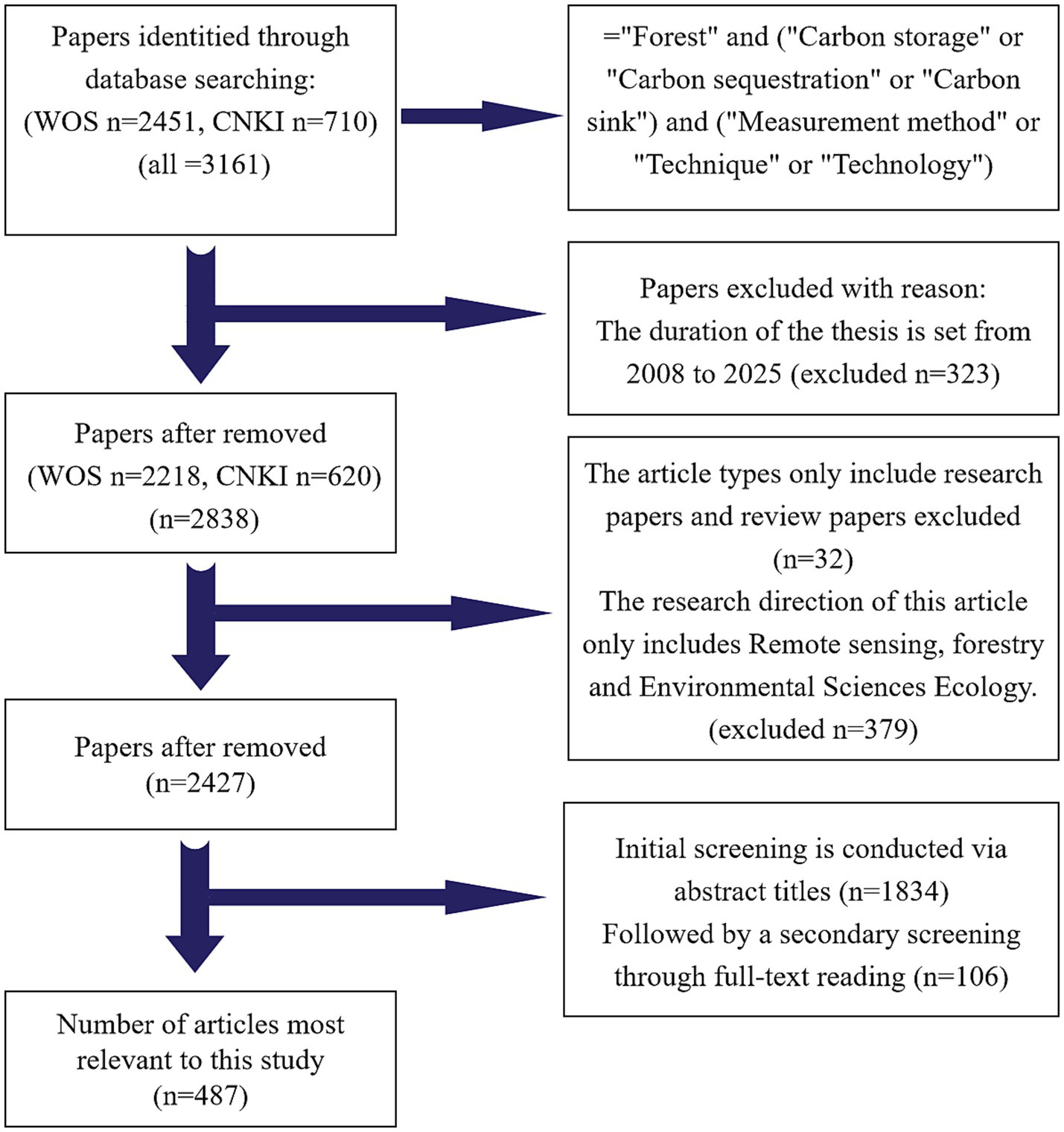
Schematic diagram of database retrieval and screening process.
2.2 Research stage development and dynamics
In the visual analysis, each network node represented a distinct entity, and the temporal dimension was indexed by publication year (Huang et al., 2023). Foundational literature on forest C-storage estimation in our knowledge network can be traced to 2008, when Professor George Burba introduced eddy-covariance (EC) corrections to reduce cold-season bias in ecosystem CO2 uptake (Burba et al., 2008). Accordingly, 2008 was selected as the starting year.
International policy milestones align with subsequent methodological development. Under the Kyoto Protocol, Parties were required to meet quantified emission-reduction targets during 2008–2012 (Protocol, 1997; Rosenqvist et al., 2003). This period was designated as Stage 1 (Figure 2). Following the entry into force of the Paris Agreement on 4 November 2016, global climate governance entered a new phase (Paris Agreement, 2015; Grassi et al., 2017). Consequently, the years from 2013 to 2017 were defined as Stage 2. In 2018, the “REddyProc” package addressed key challenges in processing raw EC flux data (Wutzler et al., 2018), and network-level advances helped resolve several long-standing issues (Baldocchi et al., 2018), motivating Stage 3 (2018–2025).
Figure 2
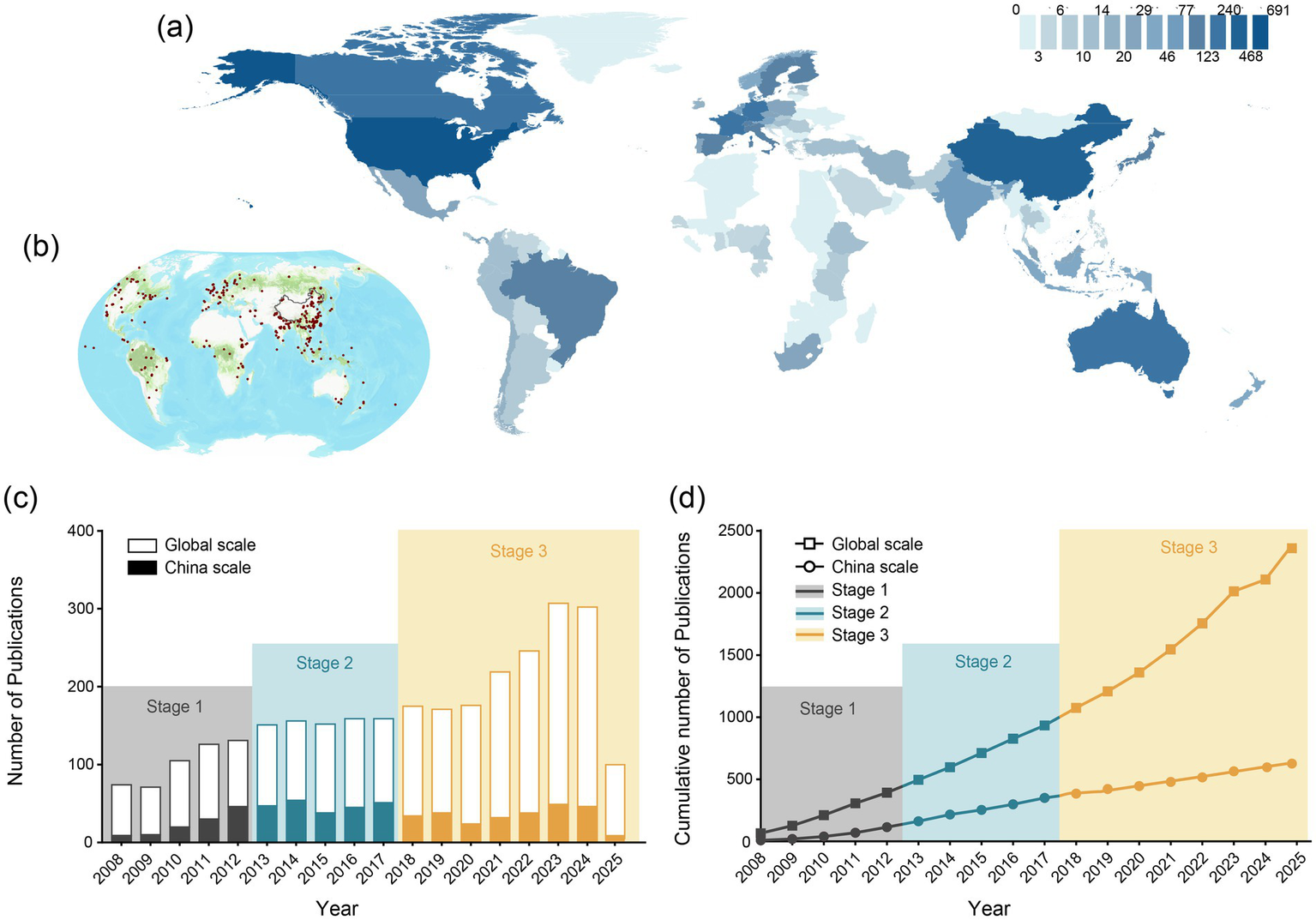
Analysis of publications related to forest carbon stock estimation techniques. (a) Global distribution of study regions. Deeper blue indicates areas with a relatively higher number of published papers. (b) The geographical distribution of research sites extracted from the related literature. The green areas represent global forest coverage, sourced from ArcGIS online maps. The red points represent the distribution of latitude and longitude coordinates for research sites extracted from the related literature. (c) Annual number of publications. (d) Cumulative number of publications. The differently colored boxes represent the three phases of development in forest carbon stock estimation techniques (2008–2012, 2013–2017, and 2018–2025).
Overall, the period 2008–2025 is divided into three stages: 2008–2012 (Stage 1), 2013–2017 (Stage 2), and 2018–2025 (Stage 3). This study systematically reviews publications within each stage to characterize distributional patterns and temporal evolution in forest C-storage estimation techniques.
2.3 Research regional scale division
The accuracy of forest C stock studies primarily relies on multi-source data fusion and model optimisation (Nguyen and Saha, 2024). By integrating ground plot measurements with RS technologies (such as Sentinel-2 and LiDAR), alongside ML models (e.g., RF, fully convolutional neural networks) and traditional regression methods (e.g., polynomial regression), researchers have made significant advancements in estimating forest C storage (Nasiri et al., 2022). Among these, regression models, especially those focusing on C storage estimation, have been refined over the years to increase their accuracy and applicability (Sun and Liu, 2019). In addition, C mapping techniques, including RS-based spatial analysis and visualization tools, have been developed to provide more detailed and geographically accurate assessments of forest C stocks (Lamichhane et al., 2019).
Over the past decade, these methods have been applied across a range of forest ecosystems, from tropical to temperate forests, and have shown a marked improvement in C stock predictions. The integration of these approaches, coupled with newer algorithms such as BO-RF (Bayesian Optimized RF), has significantly enhanced the reliability of C stock estimates by improving model precision (R2). While precision metrics like R2 have been widely applied in previous studies, recent advancements in algorithms and optimisation of feature variables have further bolstered the accuracy and reliability of C stock estimates. Hence, in this study, a meticulous selection was made from 2,427 publications, ultimately identifying 487 papers as the most relevant to the present study. From these publications, key data such as study locations, latitude and longitude, research methods, and precision (R2) were extracted and recorded. Moreover, all study location coordinates were converted into decimal format and visually displayed in Figure 2a.
Furthermore, the research areas were categorized into three scales: large, medium, and small (Huang et al., 2022). Large-scale regions generally refer to global or continental areas, medium-scale regions typically refer to national or state levels, and small-scale regions usually refer to local or regional areas. It is important to note that ownership of large-scale studies often depends on the primary research institution producing the research article. The present study systematically reviewed the literature related to these three area scales and detailed the level of research into forest C storage estimation techniques across different spatial dimensions.
2.4 Scientometrics analysis methods
Bibliometric analysis was conducted using Cite Space (V6.2.R6) software package. This package is a metric instrument that displays knowledge flow and distribution of data, within a field from perspective parametres such as scientometrics, data analysis, and information visualization, and then generates knowledge graphs for different themes (Chen, 2006). The results can intuitively show the research trends and research hotspots in certain fields, and the size of each node in the graph represents the frequency of a particular item like keywords or authors (Wang G. et al., 2023).
Furthermore, in this paper, the “ggplot2” package in R 4.5.0 software was used to draw the bar chart, the” metafor” package was used to draw the global distribution map, and it was drawn in combination with ArcGis10.8.1. Data analysis was conducted using IBM SPSS 27 (Feng et al., 2024).
3 Results
3.1 Literature output and publication analysis
The literature discussing forest C storage estimation techniques came from 121 countries located around the world. These countries were primarily distributed across the Americas, Europe, Asia, and Oceania (Figures 2a,b). The number of publications relating to forest C storage estimation techniques and the cumulative number of publications over the period ranging from 2008 to 2025 showed a steady increase in growth trend, as seen Figures 2c,d. Stage 1 in the development of forest C storage estimation techniques ranged from 2008 to 2012. During this period the average annual global number of publications was 78, with an average annual growth rate of 6%. In China, the average annual number of publications was 23, with an average annual growth rate of 39%. During Stage 2 (i.e., 2013–2017) and Stage 3 (i.e., 2018 to 2025), the average annual global publication growth rates were 1 and 3%, respectively (Figure 2c). The cumulative number of publications globally showed a continuous linear upward trend, reaching a total of 2,427 publications, with China contributing 25.5% to the publication total (Figure 2d).
3.2 Subject categories and journal distribution
The literature containing forest C storage estimation techniques covered 78 disciplinary categories and involved 823 published journals. Among the top ten disciplines was Environmental Science, which had the highest number of publications (718) (Figure 3a) and accounted for 18% of the total number of publications (Supplementary Table S1). This was followed by Forestry and Ecology, with 456 and 383 publications respectively, representing 12 and 10% of the total number of publications. The journal “Global Change Biology,” a journal closely allied to the Environmental Science discipline, published 1,306 articles, which equated to 3% of the global total. The total number of publications in “Forest Ecology and Management,” “Science,” and “Nature” was 3,072, and accounted for 7% of the total number of publications (Figure 3b; Supplementary Table S2).
Figure 3
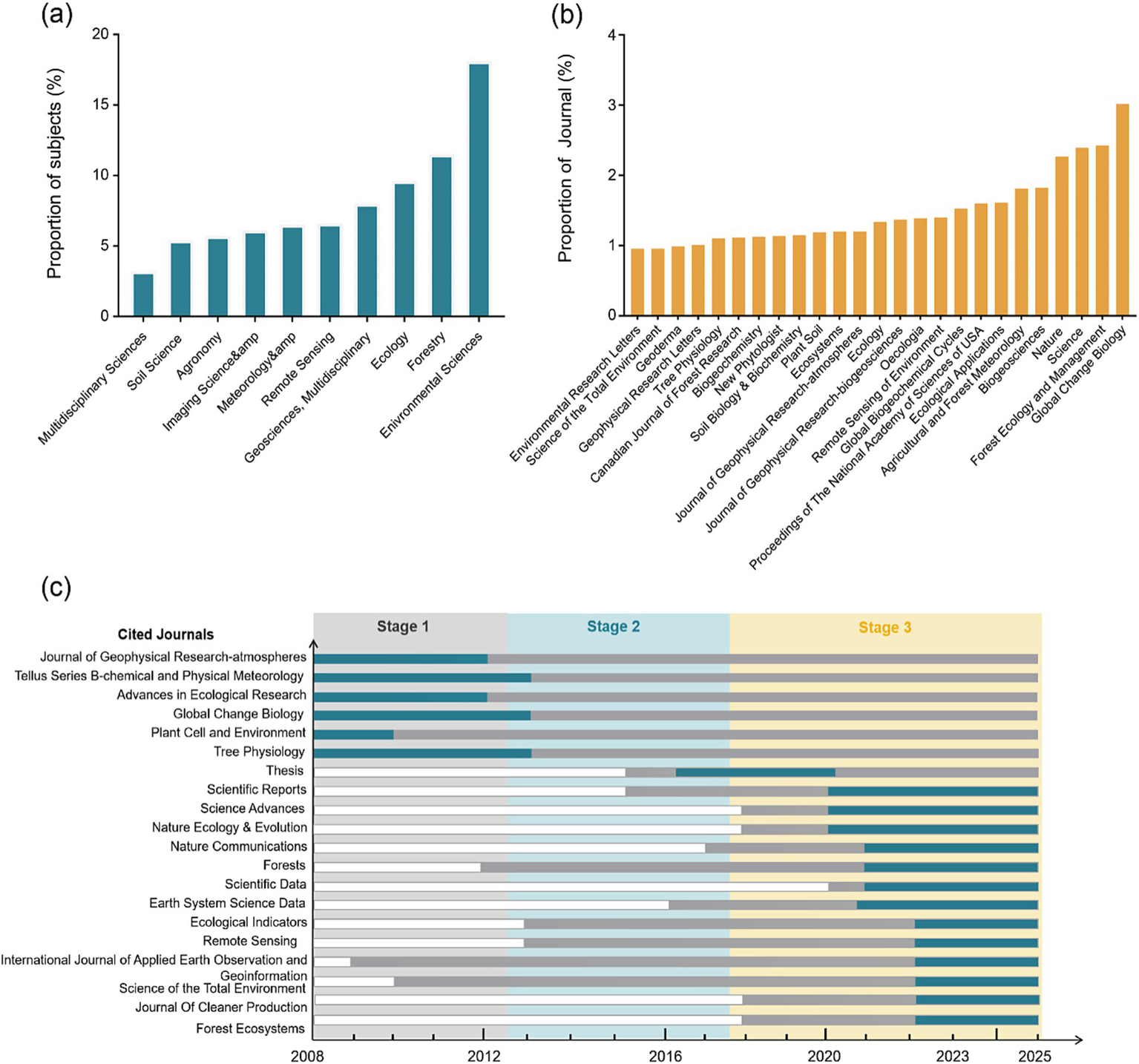
Analysis of disciplinary categories and journals related to publications on forest carbon stock estimation techniques. (a) Top 10 disciplinary categories by proportion of publications. (b) Top 25 journals by proportion of publications. (c) Burst analysis of publications related to forest carbon stock estimation techniques. The dark gray columns represent the time range in which the journal appeared, and the blue columns represent the hot range of the journal at a certain year.
Since 2008, the citation frequency of “Global Change Biology,” “Tree Physiology,” and “Journal of Geophysical Research—Atmospheres” significantly increased during Stage 1, with sustained popularity lasting 4 to 5 years (Figure 3c). The journals “RF” and “Science of the Total Environment” maintained their popularity from 2022 to 2025, with citation levels of 21 and 18, respectively (Supplementary Table S3).
3.3 Analysis of countries and institutions
The present study found the United States had the highest number of publications, with 691 papers, and accounting for 29% of the total number of publications (Figure 4a). China followed with 468 publications, making up 20% of the total number of publications. Other countries with high publication numbers included Germany (240 papers, 10%), Australia (163 papers, 7%), and France (142 papers, 6%) (Supplementary Table S4, Figure 4a). The collaboration network existing between the United States and China produced the most publications, indicating that they hold a leading global position in forest C storage estimation techniques research (Figure 4b). Among the 234 publishing institutions worldwide, the Chinese Academy of Sciences ranked first with 208 publications, accounting for 22% of the total number of publications (Supplementary Table S5). This was followed by the United States Department of Agriculture (121 papers, 13%), the United States Forest Service (98 papers, 11%), and the University of California (87 papers, 9%) (Figure 4c). The University of the Chinese Academy of Sciences ranked seventh, and the remaining institutions were located in Europe (Supplementary Table S5). These findings demonstrate that the United States is the most research active country in the field of forest C storage estimation technology, followed by China (Figure 4d).
Figure 4
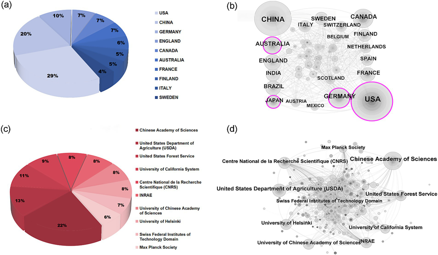
Analysis of contributions by different countries and institutions to forest carbon storage estimation techniques. (a) Top 10 countries by proportion of publications. (b) International collaboration network. (c) Top 10 institutions by proportion of publications. (d) Co-occurrence of institutional collaboration networks. Nodes represent countries, and the size of each node is related to the number of papers published by that country. Purple rings indicate high centrality.
3.4 Analysis of authors
The study identified 613 authors contributing to forest C storage estimation (2008–2025). Among the most cited, M. Reichstein (231 citations, H-index 114) introduced the model–data fusion framework, integrating soil respiration and environmental drivers to construct cross-scale models. This approach significantly improved the accuracy of dynamic simulations of forest C fluxes and advanced the use of deep learning in Earth system science (Reichstein and Beer, 2008). Eric A. Davidson (220 citations, H-index 102) combined experiments and modeling to reveal the temperature sensitivity of soil C decomposition (Davidson and Janssens, 2006). He further developed the DAMM model, linking enzyme kinetics with temperature response to simulate soil organic matter decomposition, representing a process-based modeling approach (Davidson et al., 2012).
Dennis D. Baldocchi (215 citations, H-index 133) promoted EC as a core method for ecosystem-scale CO2 fluxes, establishing its role in long-term monitoring networks such as FLUXNET (Baldocchi, 2003). Richard A. Houghton (204 citations, H-index 100) revised C flux estimates from land-use change since 1850, providing one of the most widely used approaches for global C budgets (Houghton, 2003; Houghton et al., 1999). Rattan Lal (200 citations, H-index 136) highlighted the role of soil C sequestration in climate mitigation and developed frameworks to assess soil organic C, particularly valuable in the context of C neutrality (Lal, 2004, 2013).
In addition, Jerome Chave (191 citations, H-index 91) advanced allometric equations for AGB estimation based on tree diameter, height, and wood density. These models, validated with large datasets, have become the most widely applied tools for tropical forest C estimation (Chave et al., 2005; Chave et al., 2014). Marc Aubinet (177 citations, H-index 54) standardized EC data acquisition, processing, and error control through EUROFLUX, making it the international reference for ecosystem-scale C exchange (Aubinet et al., 2012).
These contributions established a multi-scale C estimation framework, spanning tree-level (allometric models), ecosystem-level (EC and soil respiration), and global-level (land-use and C cycle models). They remain highly applicable today and, when integrated with RS and AI, are expected to further enhance the accuracy and timeliness of forest C storage assessments (Supplementary Figure S1; Table 1).
Table 1
| Method | Author(s) | Scope | Advantages | Limitations |
|---|---|---|---|---|
| Soil respiration model–data fusion | Reichstein, M. | Forest ecosystems/plot | Combines observations with environmental factors; applicable from lab to regional scale | Complex structure; requires high-quality multi-scale data |
| DAMM model | Davidson, E.A. | SOM decomposition; soil respiration | Explains carbon temperature sensitivity | Many parameters; high field data demand |
| AGB equations | Chave, J. | Tropical & subtropical forests | Simple formulas using DBH, height, density; suitable for large samples & remote sensing | Tree height difficult; density varies regionally; less accurate in sparse/high-latitude forests |
| Eddy covariance, EC | Baldocchi, D.D. and Aubinet, M. | Forests, croplands, grasslands | Non-destructive, continuous, captures interannual GPP | Errors in low night turbulence; limited by tower site & surface uniformity |
| Bookkeeping model | Houghton, R.A. | Global/regional land-use change | Long-term series; tracks deforestation & afforestation | Relies on historical data; subject to uncertainties & assumptions |
| Soil carbon sequestration framework | Lal, R. | Global soil carbon pool | Emphasizes climate mitigation role; provides accounting principles | Slow changes; long monitoring; management variability |
| Atmospheric inversion | Ciais, P. | Regional to global | Constrains fluxes with CO₂ concentration | Sensitive to network density; relies on transport models, error propagation |
Representative biomass or carbon estimation methods and their characteristics.
3.5 Keywords and keyword cluster analysis
From 2008 to 2012 (Stage 1), EC method, modeling, and RS technologies were widely applied to estimate forest C storage. Airborne LiDAR and allometric equations became the most applied technologies in Stage 2 (2013–2017). In Stage 3 (2018–2025), RF became the most frequently mentioned technology, followed by ML (Figure 5a). Notably, during this stage, forest inventory techniques, allometric equations, airborne LiDAR, digital soil mapping, and ML methods became active (Figure 5b). Among the group, both “ML” and “RF” methods registered the highest interest levels in recent years, with intensities of 13 and 9, respectively. Digital soil mapping and deep learning (DL) technologies first appeared in 2021 and 2022, respectively, and their popularity continues to the present day (Supplementary Table S6).
Figure 5
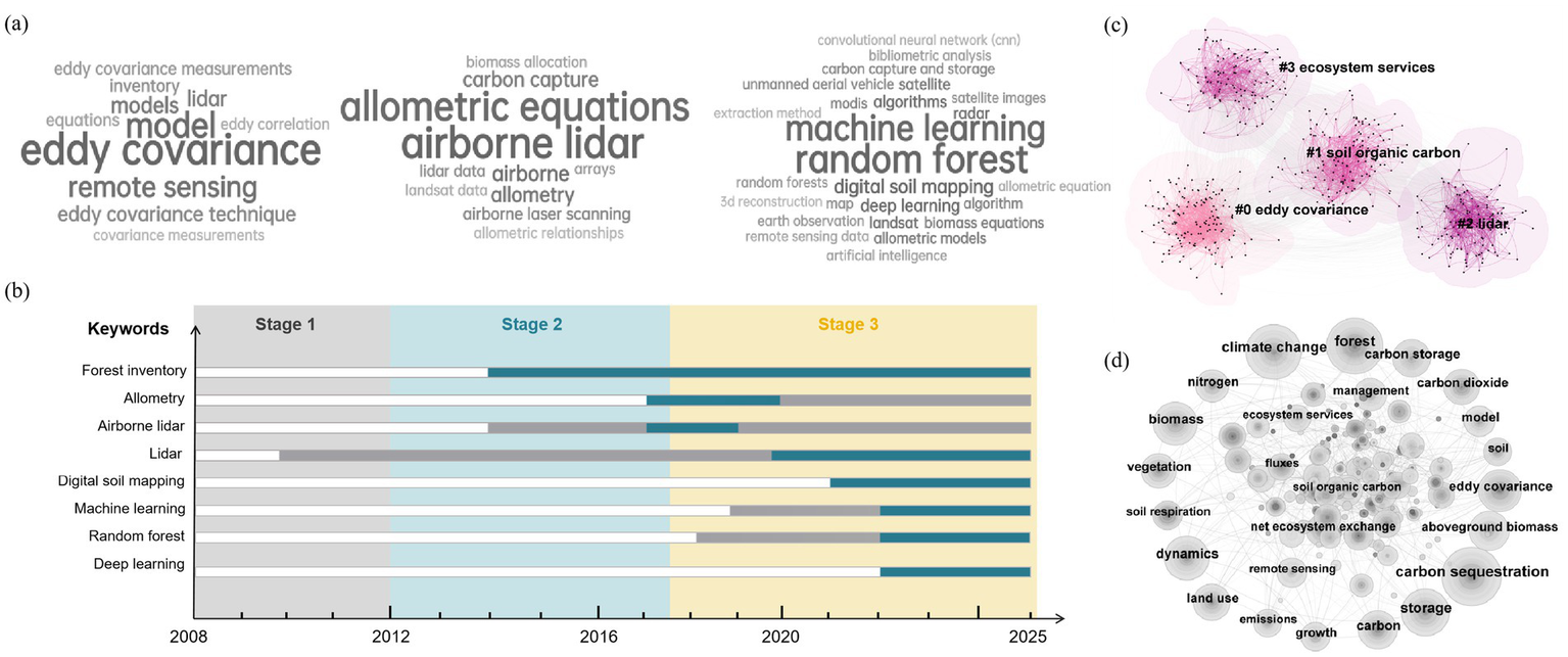
Keyword analysis of forest carbon stock estimation techniques from 2008 to 2025. (a) Analysis of keyword cloud evolution. (b) Trend analysis of keyword bursts. The dark gray columns represent the time range in which the journal appeared, and the blue columns represent the hot range of the journal at a certain year. (c) Clustering analysis of keyword citation frequency. Each node represents a keyword in the clustering diagram. The modular value Q > 0.3 and the average silhouette value S > 0.5 indicate that the cluster structure is clear and the cluster categories are reasonable. (d) Keyword co-occurrence network analysis. Lines between nodes represent connections between keywords, and the size of a node reflects the frequency of appearance or citation of the keyword.
The keyword category was divided into four main clustering groups, with each cluster containing 103–140 keywords (Figure 5c). These clusters were ranked by their co-citation frequency, which included: (1). A cluster related to EC, covering 140 keyword nodes such as ML, spatial heterogeneity, and C budget, and with an S value of 0.8; (2). The soil organic C cluster, including digital soil mapping, RF, and other key technologies; (3). A cluster centered on radar technology, encompassing RS and airborne LiDAR, etc.; (4). A group representing ecosystem services, including forest logging and forest management (Figure 5c; Supplementary Table S7). Overall, “C sequestration” appeared as the most frequently mentioned keyword, occurring 299 times. “Forest” and “Climate change” appeared 276 and 264 times, respectively. In addition, “Storage” (210 times), “biomass” (176 times), and “EC” (162 times) also appeared as significant keywords (Figure 5d; Supplementary Table S8).
3.6 The accuracy of the forest C storage estimation model
Modeling systematically extracted and analyzed data from selected articles. The trend in modeling accuracy over the three stages is presented in Figure 6a. In Stage 1 of the development of forest C storage estimation techniques (2008–2012), the average accuracy (R2) of the models was calculated to be 0.7. And by Stage 3 (2018–2025), the modeling accuracy had significantly improved, with an average R2 reaching a value of 0.77. In particular, the accuracy of the TRIPLEX-Flux C exchange model significantly increasing over time, with R2 initially being estimated to be 0.62 (Wang et al., 2012) and increasing to 0.97 (Chen et al., 2018) by the end of the final stage. Similarly, the R2 of the RF model increased from 0.63 (Wu et al., 2016) to 0.97 (Zhu et al., 2023), while the R2 of the 3-PG model was capable of reaching a value of 0.99. From a regional perspective, methods like Unmanned Aerial Vehicles (Zhang and Liang, 2020) and Global Forest AGB maps (Cunliffe et al., 2022) can be used for estimating large-scale C storage, with R2 of 0.61 and 0.82, respectively (Figure 6b).
Figure 6
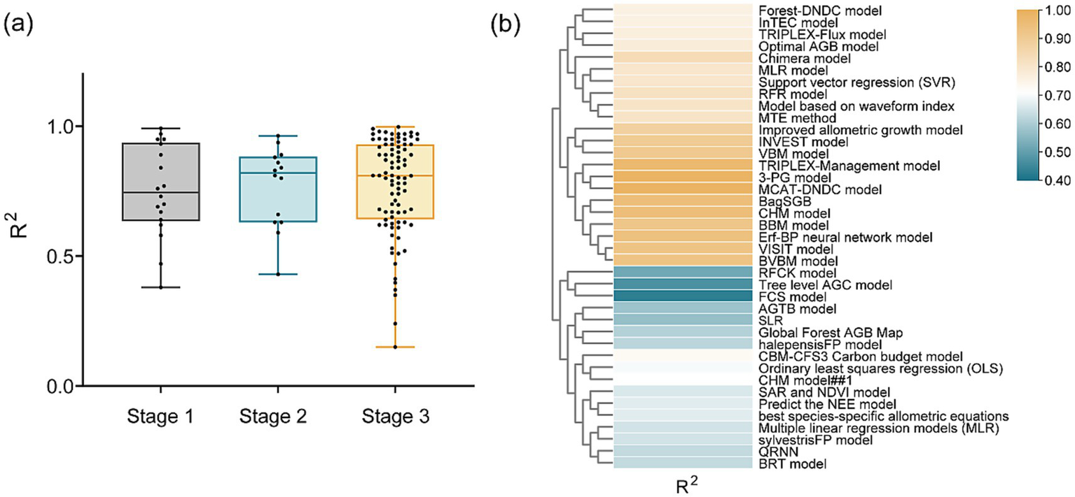
Trends in accuracy of models for forest carbon stock estimation techniques. (a) Accuracy of the models at different stages (Stage 1, 2008–2012; Stage 2, 2013–2017; Stage 3, 2018–2025). (b) Accuracy of different models. R2 is used as the unified standard for measuring accuracy.
3.7 Regional scales corresponding to forest C storage estimation techniques
Between 2008 and 2025, 8, 16, and 67 countries conducted research closely related to C storage estimation at large, medium, and small scales, respectively (Figures 7a,c,e). During this period, China had an excellent performance in research publication volume at all scales, accounting for 30, 34, and 22% of the total publications in large, medium, and small scales, respectively. In comparison, the United States also showed high levels of activity in this research field and was ranked second overall. It contributed 10, 14, and 12% to publication volumes at the large, medium, and small scales, respectively (Figures 7b,d,f).
Figure 7
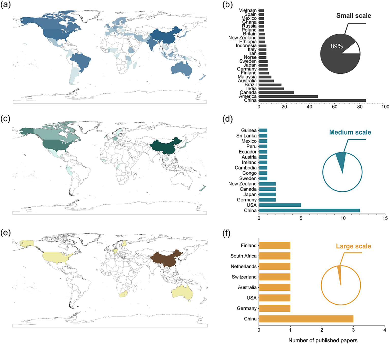
Trends in research on global forest carbon stock estimation at different scales (small, medium and large scales). (a) Number of publications on small-scale research. (b) Number of publications in individual countries corresponding to small-scale research. (c) Number of publications on medium-scale research. (d) Number of publications in individual countries corresponding to medium-scale research. (e) Number of publications on large-scale research. (f) Number of publications in individual countries corresponding to large-scale research. Deeper color indicates countries with a relatively higher number of published papers. The pie chart shows the proportion of studies on small, medium and large scales among the total literature.
4 Discussion
4.1 Development of forest C sequestration technology on time scale
Before 2008, C estimation techniques primarily relied on ground plot surveys and biomass methods, which involved directly measuring plant dry weight or estimating C stocks using EC (e.g., NPP and respiration). The establishment of frameworks such as the ISO 14040/14044 and PAS 2050 further promoted the standardization of C accounting. In terms of biomass estimation models, the Brown model predicts forest biomass based on climatic parameters (e.g., temperature and precipitation), making it suitable for large-scale studies. The IPCC default model and biomass expansion factor (BEF) model provide general estimation methods based on vegetation type and parameters like tree height and diameter, offering essential tools for early C stock research.
Since 2008, driven by international agreements such as the Kyoto Protocol and the Paris Agreement, RS and process-based models have rapidly advanced (Falkner, 2016; Grassi et al., 2017) (Figure 5). EC systems (Longdoz et al., 2008) and C cycle models (Metsaranta and Kurz, 2012) have enhanced understanding at the process level, while RS has expanded coverage to larger areas (Wicaksono et al., 2011) (Figure 6a). However, the application of this technology is not balanced: developed countries have integrated these technologies into national monitoring systems, while many developing countries face challenges such as weak infrastructure, limited funding, and land tenure disputes (Gizachew and Duguma, 2016) (Figures 4a,b). These disparities are not only significant at the scientific level but also directly limit countries’ ability to fulfill reporting obligations under the United Nations Framework Convention on Climate Change (UNFCCC) (Köhl et al., 2015; Lewis et al., 2019) (Figures 2a,b, 3). Hence, the development of forest C sequestration estimation technologies reflects both changes in scientific capacity and policy frameworks. Early reliance on EC and simple C cycle models reflected technical feasibility as well as the urgency of reporting requirements under the Kyoto Protocol. While scientifically reliable, these methods were limited to site-level observations, thus unable to provide the scale required for national or global reports.
In the next stage, LiDAR (Antonarakis et al., 2017; Assefa et al., 2017), RS (Galidaki et al., 2017), and allometric equations (Neigh et al., 2016) (Figures 3b, 5a) became the main tools. The main reasons were economic and operational: LiDAR could provide detailed canopy structure information at increasingly lower costs (Simonson et al., 2016), while allometric equations offered a practical choose between accuracy and simplicity (Huy et al., 2022; Leite et al., 2020), making them suitable for national forest inventories (Johnson et al., 2022). However, these methods still have inherent limitations. The high cost of LiDAR restricts its application in developing countries, while allometric equations face regional applicability issues (Bossy et al., 2025; Nandal et al., 2023), often underestimating biomass in diverse tropical systems. From an applied perspective, allometric equations (Johnson et al., 2024) and EC techniques are more suitable for small-scale and detailed studies, while RS technology is indispensable for medium- and large-scale regional studies (Fu et al., 2015; Wang J. et al., 2023). This discrepancy highlights the ongoing tension between technical complexity and practical feasibility. The continued reliance on simpler methods is not due to inertia but reflects the socio-economic realities of national forest inventories and C offset markets.
In recent years (2018–2025), the shift towards ML, RF, and dynamic ecosystem models (Sun et al., 2025) (Figure 5d) has been driven by improvements in computational power, the rise of open-access satellite data (e.g., Landsat, Sentinel), and the growing demand for higher accuracy under the monitoring and reporting frameworks of the Paris Agreement and UNFCCC. These methods have overcome previous limitations, enabling the capture of temporal dynamics and handling increasingly complex RS datasets (Chen Z. et al., 2023). Unlike earlier static methods, dynamic models and ML integrate heterogeneous datasets, enhancing scalability (Rodríguez-Veiga et al., 2017) (Figure 7). The advent of ML further enhances the modeling techniques’ ability to handle complex data, challenging transparency and reproducibility, which are critical for international C reporting (Bharadiya, 2023; Yu and Wang, 2025).
Additionally, soil, as an integral component of forest ecosystems (Chen et al., 2024), also requires precise C stock estimation for comprehensive forest C assessments (Coops et al., 2025). Similarly, advances in digital soil mapping have improved the estimation accuracy of underground C stocks, but fragmented soil datasets still introduce uncertainty (Assefa et al., 2017; Avitabile et al., 2016) (Figure 6b). The challenges are not only technical but also institutional: balancing method innovation with the transparency and comparability required by measurement, reporting, and verification MRV (Measurement, Reporting, and Verification) systems. However, their effectiveness depends on data availability and transparency, and the lack of open-access high-resolution RS data (particularly in tropical regions) limits their applicability, exacerbating global inequalities in C monitoring capacity.
Overall, the temporal evolution of forest C sequestration technologies reflects a clear trajectory: from descriptive, labor-intensive approaches to dynamic, data-intensive modeling. Yet each transition has left unresolved issues—unequal access for developing countries, trade-offs between precision and cost, and the slow policy uptake of advanced algorithms. Addressing these challenges will be critical for ensuring that technical progress translates into more effective global climate governance.
4.2 Development of forest C sequestration technology on space scale
At the spatial scale, the evolution of forest C stock estimation methods reflects a shift from localized plot studies to global monitoring networks (Figure 7). At the local scale, C stock estimates for forests mainly relied on manual data collection and simple models (Liang et al., 2022). Accurate ground measurements and ecological models allowed for highly precise estimates (Chave et al., 2005) (Figure 6), but these lacked scalability. While still crucial for validating RS data, these methods were costly and time-consuming. The advantage of this type of research lies in its ability to provide detailed ecological insights, especially revealing the impacts of climate change on forest C stocks (Cusack et al., 2016). However, relying solely on local studies can lead to fragmented knowledge, making it insufficient for supporting national-level reports and limiting its broader application in policy.
At the national scale, forest inventory data, containing detailed information about tree diameter, height, species, crown cover, and other parameters, combined with RS technologies, has made C stock assessment more systematic. Countries with established forest inventory systems, such as the United States and China, have used this data to design C sink policies and fulfill international reporting obligations. However, significant differences in governance capacities among countries exist. In countries with weak institutions, forest inventory data is often incomplete or outdated, reducing the accuracy of C estimates and impacting their credibility in international C markets. This disparity raises an important policy issue: Should global climate financing mechanisms invest more in building MRV capacity in developing countries rather than solely funding technological upgrades?
At the global scale, satellite-based Earth observation systems (e.g., MODIS, Landsat) and collaborative initiatives like GFOI and the Global C Project (Avitabile et al., 2016) have expanded monitoring coverage (Liu W. et al., 2024; Zhang et al., 2025), with integrating data from different countries being key for C stock estimation (Abbas et al., 2020; Tigabu and Gessesse, 2025). However, technical limitations still exist, such as the varying resolution of RS products, cloud interference affecting continuity, and data-sharing barriers hindering progress. Moreover, while global datasets are effective in monitoring long-term C dynamics, they often lack the socio-ecological details required for regional policymaking. Therefore, a key challenge is how to balance the broad scope of global monitoring with the depth of local social-ecological contexts.
Overall, the development trajectory of forest C stock estimation technologies is clear: from ground-based surveys to dynamic, data-intensive modeling, and from local studies to global monitoring systems. The expansion of forest monitoring at the spatial scale has brought both opportunities and constraints. Each technological evolution has improved accuracy and scalability but has also introduced new challenges: unequal access to data across regions, trade-offs between technical sophistication and economic feasibility, and the slow uptake of advanced algorithms in policy. Future progress should not rely solely on technological innovations but on addressing these systemic issues, including strengthening capacity-building in developing countries, improving data-sharing mechanisms, and ensuring transparency and comparability in advanced models. Only with integration at the technical, institutional, and socio-economic levels can forest C monitoring truly support effective climate governance and promote fair participation in global C markets.
4.3 Policy, socio-economic, and ecological drivers
Technological adoption in forest C estimation cannot be understood in isolation from broader drivers. Policy incentives, such as REDD+ and national C markets, have been instrumental in promoting MRV-related methods (Redd and Ecuador, 2012). In developed economies, significant public investment has accelerated uptake of costly RS systems, while in many African and Southeast Asian countries, weak infrastructure and limited financial resources restrict the deployment of advanced technologies (Ali, 2022; George, 2000). This imbalance raises concerns for the equity and credibility of global C accounting, as regions with the largest forest C stocks are often least equipped to measure them accurately (Gifford, 2020).
Socio-economic constraints also influence methodological choices. High-resolution RS and LiDAR demand substantial data storage, processing power, and technical expertise, which create barriers for under-resourced institutions (Di and Yu, 2023; von Essen et al., 2025). Data-sharing issues exacerbate this divide; proprietary restrictions on satellite datasets or national forest inventories impede collective progress (Gessler et al., 2024). In contrast, community-based ground measurements and low-cost allometric methods, while limited in scalability, continue to play a crucial role in local contexts where high-tech methods remain inaccessible (Brofeldt et al., 2014; Venter et al., 2015).
From an ecological perspective, methodological evolution reflects the need to capture increasing complexity. Static biomass equations overlook dynamic processes such as mortality, disturbance, and soil C fluxes. Recent digital soil mapping and deep learning approaches attempt to address these gaps, but they also introduce new uncertainties related to algorithm transparency and overfitting. This suggests that methodological progress has been less about linear “improvement” and more about navigating trade-offs between cost, complexity, and ecological realism (Ball et al., 2017).
4.4 The limitations of this study
Although this bibliometric synthesis offers a broad overview of advances in forest C storage estimation, several limitations warrant consideration (Huang et al., 2020).
-
(1) Our approach relies on indexed journal literature and bibliometric tools, which may not fully capture operational practices, grey literature, proprietary workflows, or emerging techniques that have yet to appear in citable outlets. As a result, some methods currently used in practice could be underrepresented.
-
(2) To maintain thematic coherence, screening focused on forestry and environmental-science venues. This necessarily constrains interdisciplinary coverage, and relevant insights from adjacent domains (e.g., agricultural sciences, climate modeling, geodesy/remote-sensing engineering, and environmental economics) may lie outside our corpus. The omission of such work can limit methodological breadth and weaken links to policy and market implementation.
-
(3) Non-living C pools are also comparatively underrepresented. Litter and coarse woody debris are inventoried less frequently than living biomass and soil organic C, even though litter-layer C in temperate forests can amount to ~5–15% of soil organic C. Excluding this component risks systematic bias in regional C-sink assessments and can propagate uncertainty into carbon-cycle models.
-
(4) The use of bibliometric analysis inevitably introduces inherent biases. One significant limitation is language bias, as non-English literature (such as articles in Chinese or Spanish) is often underrepresented. This could lead to an underestimation of the contributions from regional studies. Furthermore, the study’s reliance on Web of Science and CNKI for literature sources may have resulted in limited coverage of relevant articles, excluding valuable data from other regional or non-mainstream databases.
-
(5) Bibliometric approaches exhibit a recency lag. Very recent innovations, in-progress applications, embargoed datasets, and projects without citable outputs are difficult to capture, so our synthesis may not reflect the most current operational performance. These caveats contextualize the findings and highlight priorities for future work, including broader database integration, multilingual screening and expert elicitation, and more systematic accounting of dead-organic-matter pools.
4.5 Evaluation and future feasibility of forest C sequestration technologies
Despite significant advances, several unresolved challenges limit the operationalization of forest C estimation techniques in policy contexts.
-
(1) Technical validation and comparability: Models such as RF and TRIPLEX-Flux have shown high accuracy (R2 > 0.9), yet their transferability across forest types remains uncertain (Liu Y. et al., 2024). Comparative validation with standardized field data is essential to ensure credibility for UNFCCC reporting.
-
(2) Scalability and equity: Without stronger international collaboration, including open-access RS platforms and shared protocols, large-scale monitoring will remain dominated by a few well-funded regions. This threatens the inclusivity of mechanisms like REDD+.
-
(3) Integration of ecological complexity: Soil C pools, disturbance regimes, and human management practices are still weakly integrated into most estimation frameworks. Future models should move beyond aboveground biomass to incorporate multi-pool C dynamics.
-
(4) Uncertainty quantification: Advanced sensitivity and uncertainty analyses are required to provide transparent confidence intervals for policymakers.
-
(5) Long-term monitoring under climate change: Dynamic models and long-term datasets need to explicitly incorporate climate variability and land-use change scenarios. This is crucial for aligning science with the Paris Agreement’s five-year global stocktake cycle.
In summary, the evolution of forest C estimation technologies has been shaped as much by socio-economic and policy forces as by scientific innovation. To ensure their future feasibility, research must embrace interdisciplinary integration, global equity in data access, and stronger alignment with international climate reporting requirements.
5 Conclusion
Based on the comprehensive analysis of publications ranging from 2008 to 2025, the present study has revealed a significant increase in global research aimed at estimating forest carbon (C) storage. The techniques for estimating forest C storage levels have evolved over time. From an early (2008–2012) reliance on eddy covariance and remote sensing (RS) to a mid-term (2013–2017) focus on model simulations. And in recent years (2018–2025), the widespread use of machine learning (ML) and biomass mapping techniques. These advancements have not only improved estimation accuracy, but they have also facilitated more in-depth studies at small and medium scales. However, very few large-scale studies have been undertaken. With increasing quantities of data collected by RS technologies and ground surveys, methods such as ML and random forests (RF) have gradually become the focus of recent research. These methods can effectively predict forest C storage levels and efficiently process massive amounts of RS data. However, future research is needed to integrate data from across the various scales and combine ecological modeling with RS technologies to develop effective global long-term dynamic monitoring. Furthermore, the utilisation of unmanned aerial vehicles and updated data sources can further enhance estimation accuracy. Thus, enabling accurate and efficient assessment and management of global forest C stocks.
Statements
Data availability statement
The original contributions presented in the study are included in the article/Supplementary material, further inquiries can be directed to the corresponding authors.
Author contributions
YF: Investigation, Writing – original draft, Methodology. JL: Writing – review & editing, Data curation, Visualization. HH: Writing – review & editing, Supervision, Resources. PC: Visualization, Writing – review & editing, Investigation. HZ: Writing – review & editing. BM: Writing – review & editing. ZL: Writing – review & editing. DC: Writing – review & editing.
Funding
The author(s) declare that financial support was received for the research and/or publication of this article. We appreciate the funding by Jiangsu Province Carbon peak and carbon neutrality and Technology Innovation Special Fund Project in 2021 (BE2022305), Jiangsu Yangtze River Delta Forest Ecosystem Localization Research Project, National Forestry and Grassland Administration (2022132077), Jiangsu Province Comprehensive Survey on Ecological and Geological Environment of Important Ecological Function Areas in the Taihu Lake Basin (2200113), Jiangsu Provincial Higher Education Basic Science (Natural Science) Research Project (25KJB210009), Changzhou Ecological Green City Construction Research Project in 2021 (2021-108).
Conflict of interest
ZL was employed by Jiangsu Changhuan Environmental Technology Co.
The remaining authors declare that the research was conducted in the absence of any commercial or financial relationships that could be construed as a potential conflict of interest.
Generative AI statement
The author(s) declare that no Gen AI was used in the creation of this manuscript.
Any alternative text (alt text) provided alongside figures in this article has been generated by Frontiers with the support of artificial intelligence and reasonable efforts have been made to ensure accuracy, including review by the authors wherever possible. If you identify any issues, please contact us.
Publisher’s note
All claims expressed in this article are solely those of the authors and do not necessarily represent those of their affiliated organizations, or those of the publisher, the editors and the reviewers. Any product that may be evaluated in this article, or claim that may be made by its manufacturer, is not guaranteed or endorsed by the publisher.
Supplementary material
The Supplementary material for this article can be found online at: https://www.frontiersin.org/articles/10.3389/ffgc.2025.1649356/full#supplementary-material
References
1
Abbas S. Wong M. S. Wu J. Shahzad N. Muhammad Irteza S. (2020). Approaches of satellite remote sensing for the assessment of above-ground biomass across tropical forests: pan-tropical to national scales. Remote Sens12:3351. doi: 10.3390/rs12203351
2
Ali I. (2022). Sustainable for all? How satellite remote sensing contributes to sustainable development in Africa and international climate policy. (Doctoral dissertation, Massachusetts Institute of Technology).
3
Antonarakis A. Siqueira P. Munger J. (2017). Using multi-source data from lidar, radar, imaging spectroscopy, and national forest inventories to simulate forest carbon fluxes. Int. J. Remote Sens.38, 5464–5486. doi: 10.1080/01431161.2017.1341666
4
Assefa D. Rewald B. Sandén H. Rosinger C. Abiyu A. Yitaferu B. et al . (2017). Deforestation and land use strongly effect soil organic carbon and nitrogen stock in Northwest Ethiopia. Catena153, 89–99. doi: 10.1016/j.catena.2017.02.003
5
Aubinet M. Vesala T. Papale D. (Eds.). (2012). Eddy covariance: A practical guide to measurement and data analysis. Springer Dordrecht Heidelberg, London, New York: Springer Science & Business Media. doi: 10.1007/978-94-007-2351-1
6
Avitabile V. Herold M. Heuvelink G. B. Lewis S. L. Phillips O. L. Asner G. P. et al . (2016). An integrated pan-tropical biomass map using multiple reference datasets. Glob. Change Biol.22, 1406–1420. doi: 10.1111/gcb.13139
7
Baldocchi D. D. (2003). Assessing the eddy covariance technique for evaluating carbon dioxide exchange rates of ecosystems: past, present and future. Glob. Change Biol.9, 479–492. doi: 10.1046/j.1365-2486.2003.00629.x
8
Baldocchi D. Chu H. Reichstein M. (2018). Inter-annual variability of net and gross ecosystem carbon fluxes: a review. Agric. For. Meteorol.249, 520–533. doi: 10.1016/j.agrformet.2017.05.015
9
Ball J. E. Anderson D. T. Chan C. S. (2017). Comprehensive survey of deep learning in remote sensing: theories, tools, and challenges for the community. J. Appl. Remote. Sens.11:042609. doi: 10.1117/1.JRS.11.042609
10
Berner L. T. Goetz S. J. (2022). Satellite observations document trends consistent with a boreal forest biome shift. Glob. Chang. Biol.28, 3275–3292. doi: 10.1111/gcb.16121
11
Bharadiya J. P. (2023). A review of Bayesian machine learning principles, methods, and applications. Int. J. Innov. Sci. Res. Technol.8, 2033–2038.
12
Bossy T. Ciais P. Renaudineau S. Wan L. Ygorra B. Adam E. et al . (2025). State of the art and for remote sensing monitoring of carbon dynamics in African tropical forests. Front. Remote Sens.6:1532280. doi: 10.3389/frsen.2025.1532280
13
Brofeldt S. Theilade I. Burgess N. D. Danielsen F. Poulsen M. K. Adrian T. et al . (2014). Community monitoring of carbon stocks for REDD+: does accuracy and cost change over time?Forests5, 1834–1854. doi: 10.3390/f5081834
14
Burba G. G. McDermitt D. K. Grelle A. Anderson D. J. Xu L. (2008). Addressing the influence of instrument surface heat exchange on the measurements of CO2 flux from open-path gas analyzers. Glob. Change Biol.14, 1854–1876. doi: 10.1111/j.1365-2486.2008.01606.x
15
Chave J. Andalo C. Brown S. Cairns M. A. Chambers J. Q. Eamus D. et al . (2005). Tree allometry and improved estimation of carbon stocks and balance in tropical forests. Oecologia145, 87–99. doi: 10.1007/s00442-005-0100-x
16
Chave J. Réjou-Méchain M. Búrquez A. Chidumayo E. Colgan M. S. Delitti W. B. et al . (2014). Improved allometric models to estimate the aboveground biomass of tropical trees. Glob. Change Biol.20, 3177–3190. doi: 10.1111/gcb.12629
17
Chen C. (2006). Citespace II: detecting and visualizing emerging trends and transient patterns in scientific literature. J. Am. Soc. Inf. Sci. Technol.57, 359–377. doi: 10.1002/asi.20317
18
Chen Q. Li X. Zhang Z. Zhou C. Guo Z. Liu Z. et al . (2023). Remote sensing of photovoltaic scenarios: techniques, applications and future directions. Appl. Energy333:120579. doi: 10.1016/j.apenergy.2022.120579
19
Chen S. Jiang H. Cai Z. Zhou X. Peng C. (2018). The response of the net primary production of Moso bamboo forest to the on and off-year management: a case study in Anji County, Zhejiang, China. For. Ecol. Manag.409, 1–7. doi: 10.1016/j.foreco.2017.11.008
20
Chen X. Hu H. Wang Q. Wang X. Ma B. (2024). Exploring the factors affecting terrestrial soil respiration in global warming manipulation experiments based on meta-analysis. Agriculture,14:1581.
21
Chen Z. Chen J. Xu G. Sha Z. Yin J. Li Z. (2023). Estimation and climate impact analysis of terrestrial vegetation net primary productivity in China from 2001 to 2020. Land12:1223. doi: 10.3390/land12061223
22
Coops N. C. Irwin L. A. Seely H. S. Hardy S. J. (2025). Advances in laser scanning to assess carbon in forests: from ground-based to space-based sensors. Curr. Forestry Rep.11, 1–22. doi: 10.1007/s40725-024-00242-4
23
Cunliffe A. M. Anderson K. Boschetti F. Brazier R. E. Graham H. A. Myers-Smith I. H. et al . (2022). Global application of an unoccupied aerial vehicle photogrammetry protocol for predicting aboveground biomass in non-forest ecosystems. Remote Sens. Ecol. Conserv.8, 57–71. doi: 10.1002/rse2.228
24
Cusack D. F. Karpman J. Ashdown D. Cao Q. Ciochina M. Halterman S. et al . (2016). Global change effects on humid tropical forests: evidence for biogeochemical and biodiversity shifts at an ecosystem scale. Rev. Geophys.54, 523–610. doi: 10.1002/2015RG000510
25
Davidson E. A. Janssens I. A. (2006). Temperature sensitivity of soil carbon decomposition and feedbacks to climate change. Nature440, 165–173. doi: 10.1038/nature04514
26
Davidson E. A. Samanta S. Caramori S. S. Savage K. (2012). The d ual a rrhenius and M ichaelis–M enten kinetics model for decomposition of soil organic matter at hourly to seasonal time scales. Glob. Change Biol.18, 371–384. doi: 10.1111/j.1365-2486.2011.02546.x
27
Di L. Yu E. (2023). “Challenges and opportunities in the remote sensing big data” in Remote sensing big data. Springer Remote Sensing/Photogrammetry. Springer, Cham. doi: 10.1007/978-3-031-33932-5_18
28
Fahey T. J. Woodbury P. B. Battles J. J. Goodale C. L. Hamburg S. P. Ollinger S. V. et al . (2010). Forest carbon storage: ecology, management, and policy. Front. Ecol. Environ.8, 245–252. doi: 10.1890/080169
29
Falkner R. (2016). The Paris agreement and the new logic of international climate politics. Int. Aff.92, 1107–1125. doi: 10.1111/1468-2346.12708
30
FAO (2010). Global forest resources assessment 2010. The main report. Food and Agriculture Organization of the United Nations, Rome.
31
Feng Y. Liu J. Hu H. Xu X. Chen D. Wang X. et al . (2024). Agroforestry system construction in eastern coastal China: insights from soil–plant interactions. Land Degrad. Dev.35, 2530–2542. doi: 10.1002/ldr.5078
32
Fu L. Zhao Y. Xu Z. Wu B. (2015). Spatial and temporal dynamics of forest aboveground carbon stocks in response to climate and environmental changes. J. Soils Sediments15, 249–259. doi: 10.1007/s11368-014-1050-x
33
Galidaki G. Zianis D. Gitas I. Radoglou K. Karathanassi V. Tsakiri–Strati M. et al . (2017). Vegetation biomass estimation with remote sensing: focus on forest and other wooded land over the Mediterranean ecosystem. Int. J. Remote Sens.38, 1940–1966. doi: 10.1080/01431161.2016.1266113
34
George H. (2000). Developing countries and remote sensing: how intergovernmental factors impede progress. Space Policy16, 267–273. doi: 10.1016/S0265-9646(00)00042-4
35
Gessler A. Schaub M. Bose A. Trotsiuk V. Valbuena R. Chirici G. et al . (2024). Finding the balance between open access to forest data while safeguarding the integrity of National Forest Inventory-derived information. New Phytol.242, 344–346. doi: 10.1111/nph.19466
36
Gifford L. (2020). “You can’t value what you can’t measure”: a critical look at forest carbon accounting. Clim. Chang.161, 291–306. doi: 10.1007/s10584-020-02653-1
37
Gizachew B. Duguma L. A. (2016). Forest carbon monitoring and reporting for REDD+: what future for Africa?Environ. Manag.58, 922–930. doi: 10.1007/s00267-016-0762-7
38
Goetz S. J. Baccini A. Laporte N. T. Johns T. Walker W. Kellndorfer J. et al . (2009). Mapping and monitoring carbon stocks with satellite observations: a comparison of methods. Carbon Balance Manag.4:2. doi: 10.1186/1750-0680-4-2
39
Grassi G. House J. Dentener F. Federici S. Den Elzen M. Penman J. (2017). The key role of forests in meeting climate targets requires science for credible mitigation. Nat. Clim. Chang.7, 220–226. doi: 10.1038/nclimate3227
40
Green J. K. Keenan T. F. (2022). The limits of forest carbon sequestration. Science376, 692–693. doi: 10.1126/science.abo6547
41
Hao Y. Mao J. Bachmann C. M. Hoffman F. M. Koren G. Chen H. et al . (2025). Soil moisture controls over carbon sequestration and greenhouse gas emissions: a review. NPJ Clim. Atmos. Sci.8:16. doi: 10.1038/s41612-024-00888-8
42
Houghton R. A. (2003). Revised estimates of the annual net flux of carbon to the atmosphere from changes in land use and land management 1850–2000. Tellus B.55, 378–390. doi: 10.1034/j.1600-0889.2003.01450.x
43
Houghton R. A. Hackler J. L. Lawrence K. T. (1999). The US carbon budget: contributions from land-use change. Science285, 574–578. doi: 10.1126/science.285.5427.574
44
Huang J. Feng Y. Xie H. Wu P. Wang M. Wang B. et al . (2023). A bibliographic study reviewing the last decade of hydrochar in environmental application: history, status quo, and trending research paths. Biochar5:12. doi: 10.1007/s42773-023-00210-4
45
Huang J. Wu X. Ling S. Li X. Wu Y. Peng L. et al . (2022). A bibliometric and content analysis of research trends on GIS-based landslide susceptibility from 2001 to 2020. Environ. Sci. Pollut. Res.29, 86954–86993. doi: 10.1007/s11356-022-23732-z
46
Huang L. Zhou M. Lv J. Chen K. (2020). Trends in global research in forest carbon sequestration: a bibliometric analysis. J. Clean. Prod.252:119908. doi: 10.1016/j.jclepro.2019.119908
47
Huy B. Truong N. Q. Khiem N. Q. Poudel K. P. Temesgen H. (2022). Deep learning models for improved reliability of tree aboveground biomass prediction in the tropical evergreen broadleaf forests. For. Ecol. Manag.508:120031. doi: 10.1016/j.foreco.2022.120031
48
Intergovernmental Panel on Climate Change (IPCC) (2019). 2019 refinement to the 2006 IPCC guidelines for national greenhouse gas inventories. Agriculture, forestry and other land use, 4, 824
49
Johnson L. K. Mahoney M. J. Bevilacqua E. Stehman S. V. Domke G. M. Beier C. M. (2022). Fine-resolution landscape-scale biomass mapping using a spatiotemporal patchwork of LiDAR coverages. Int. J. Appl. Earth Obs. Geoinf.114:103059. doi: 10.1016/j.jag.2022.103059
50
Johnson L. K. Mahoney M. J. Domke G. Beier C. M. (2024). New allometric models for the USA create a step-change in forest carbon estimation, modeling, and mapping. arXiv. doi: 10.48550/arXiv.2405.04507
51
Kang Y. Özdoğan M. Zipper S. C. Román M. O. Walker J. Hong S. Y. et al . (2016). How universal is the relationship between remotely sensed vegetation indices and crop leaf area index? A global assessment. Remote Sens8:597. doi: 10.3390/rs8070597
52
Khan K. Khan S. N. Ali A. Khokhar M. F. Khan J. A. (2025). Estimating aboveground biomass and carbon sequestration in afforestation areas using optical/SAR data fusion and machine learning. Remote Sens17:934. doi: 10.3390/rs17050934
53
Köhl M. Lasco R. Cifuentes M. Jonsson Ö. Korhonen K. T. Mundhenk P. et al . (2015). Changes in forest production, biomass and carbon: results from the 2015 UN FAO global forest resource assessment. For. Ecol. Manag.352, 21–34. doi: 10.1016/j.foreco.2015.05.036
54
Lal R. (2004). Soil carbon sequestration impacts on global climate change and food security. Science304, 1623–1627. doi: 10.1126/science.1097396
55
Lal R. (2013). Soil carbon management and climate change. Carbon Manag.4, 439–462. doi: 10.4155/cmt.13.31
56
Lamichhane S. Kumar L. Wilson B. (2019). Digital soil mapping algorithms and covariates for soil organic carbon mapping and their implications: a review. Geoderma352, 395–413. doi: 10.1016/j.geoderma.2019.05.031
57
Lázaro-Lobo A. Ruiz-Benito P. Cruz-Alonso V. Castro-Díez P. (2023). Quantifying carbon storage and sequestration by native and non-native forests under contrasting climate types. Glob. Chang. Biol.29, 4530–4542. doi: 10.1111/gcb.16810
58
Leite R. V. Amaral C. H. D. Pires R. D. P. Silva C. A. Soares C. P. B. Macedo R. P. et al . (2020). Estimating stem volume in eucalyptus plantations using airborne LiDAR: a comparison of area-and individual tree-based approaches. Remote Sens12:1513. doi: 10.3390/rs12091513
59
Lewis S. L. Wheeler C. E. Mitchard E. T. Koch A. (2019). Restoring natural forests is the best way to remove atmospheric carbon. Nature568, 25–28. doi: 10.1038/d41586-019-01026-8
60
Liang X. Kukko A. Balenović I. Saarinen N. Junttila S. Kankare V. et al . (2022). Close-range remote sensing of forests: the state of the art, challenges, and opportunities for systems and data acquisitions. IEEE Geosci. Remote Sens. Mag.10, 32–71. doi: 10.1109/MGRS.2022.3168135
61
Liu S. Dong Y. Liu H. Wang F. Yu L. (2023). Review of valuation of forest ecosystem services and realization approaches in China. Land12:1102. doi: 10.3390/land12051102
62
Liu Y. Liu H. Xu W. Wang L. Wang Q. Ou G. et al . (2024). Advances and challenges of carbon storage estimation in tea plantation. Ecol. Inform.81:102616. doi: 10.1016/j.ecoinf.2024.102616
63
Liu W. Zhang X. Xu H. Zhao T. Wang J. Li Z. et al . (2024). Characterizing the accelerated global carbon emissions from forest loss during 1985–2020 using fine-resolution remote sensing datasets. Remote Sens16:978. doi: 10.3390/rs16060978
64
Longdoz B. Gross P. Granier A. (2008). Multiple quality tests for analysing CO2 fluxes in a beech temperate forest. Biogeosciences5, 719–729. doi: 10.5194/bg-5-719-2008
65
Metsaranta J. Kurz W. (2012). Inter-annual variability of ecosystem production in boreal jack pine forests (1975–2004) estimated from tree-ring data using CBM-CFS3. Ecol. Model.224, 111–123. doi: 10.1016/j.ecolmodel.2011.10.026
66
Mo L. Zohner C. M. Reich P. B. Liang J. De Miguel S. Nabuurs G.-J. et al . (2023). Integrated global assessment of the natural forest carbon potential. Nature624, 92–101. doi: 10.1038/s41586-023-06723-z
67
Nandal A. Yadav S. S. Rao A. S. Meena R. S. Lal R. (2023). Advance methodological approaches for carbon stock estimation in forest ecosystems. Environ. Monit. Assess.195:315. doi: 10.1007/s10661-022-10898-9
68
Nasiri V. Darvishsefat A. A. Arefi H. Griess V. C. Sadeghi S. M. M. Borz S. A. (2022). Modeling forest canopy cover: a synergistic use of Sentinel-2, aerial photogrammetry data, and machine learning. Remote Sens14:1453. doi: 10.3390/rs14061453
69
Neigh C. S. Masek J. G. Bourget P. Rishmawi K. Zhao F. Huang C. et al . (2016). Regional rates of young US forest growth estimated from annual Landsat disturbance history and IKONOS stereo imagery. Remote Sens. Environ.173, 282–293. doi: 10.1016/j.rse.2015.09.007
70
Nguyen A. Saha S. (2024). Machine learning and multi-source remote sensing in forest carbon stock estimation: a review. arXiv. doi: 10.48550/arXiv.2411.17624
71
Paris Agreement (2015). “Paris agreement” in Report of the conference of the parties to the United Nations framework convention on climate change (Paris: HeinOnline).
72
Peng S. L. Wen D. He N. P. Yu G. R. Ma A. N. Wang Q. F. (2016). Carbon storage in China's forest ecosystems: estimation by different integrative methods. Ecol. Evol.6, 3129–3145. doi: 10.1002/ece3.2114
73
Protocol K. (1997). Kyoto protocol. UNFCCC website. (accessed January 1, 2011). Available online at: http://unfccc.int/kyoto_protocol/items/2830.php
74
Redd I. Ecuador I. (2012). Forest carbon, markets and communities (FCMC) program
75
Reichstein M. Beer C. (2008). Soil respiration across scales: the importance of a model–data integration framework for data interpretation. J. Plant Nutr. Soil Sci.171, 344–354. doi: 10.1002/jpln.200700075
76
Rodda S. R. Fararoda R. Gopalakrishnan R. Jha N. Réjou-Méchain M. Couteron P. et al . (2024). LiDAR-based reference aboveground biomass maps for tropical forests of South Asia and Central Africa. Sci Data11:334. doi: 10.1038/s41597-024-03162-x
77
Rodríguez-Veiga P. Wheeler J. Louis V. Tansey K. Balzter H. (2017). Quantifying forest biomass carbon stocks from space. Curr. Forestry Rep.3, 1–18. doi: 10.1007/s40725-017-0052-5
78
Rosenqvist Å. Milne A. Lucas R. Imhoff M. Dobson C. (2003). A review of remote sensing technology in support of the Kyoto Protocol. Environ. Sci. Pol.6, 441–455. doi: 10.1016/S1462-9011(03)00070-4
79
Simonson W. Ruiz-Benito P. Valladares F. Coomes D. (2016). Modelling above-ground carbon dynamics using multi-temporal airborne lidar: insights from a Mediterranean woodland. Biogeosciences13, 961–973. doi: 10.5194/bg-13-961-2016
80
Stancliffe R. Eling J. Barker J. (2024). Climate change is a clear and present danger to health, says UKHSA. BMJ384:q66. doi: 10.1136/bmj.q66
81
Sun Y. Li L. Yang Q. Zong B. (2025). Visualization of forest education using CiteSpace: a bibliometric analysis. Forests16:985. doi: 10.3390/f16060985
82
Sun W. Liu X. (2019). Review on carbon storage estimation of forest ecosystem and applications in China. Forest Ecosyst.7:4. doi: 10.1186/s40663-019-0210-2
83
Tigabu A. Gessesse A. A. (2025). Mapping forest cover change and estimating carbon stock using satellite-derived vegetation indices in Alemsaga forest, Ethiopia. PLoS One20:e0310780. doi: 10.1371/journal.pone.0310780
84
Venter M. Venter O. Edwards W. Bird M. I. (2015). Validating community-led forest biomass assessments. PLoS One10:e0130529. doi: 10.1371/journal.pone.0130529
85
von Essen M. Carlson K. M. Ordway E. M. Sonwa D. J. Boyd W. (2025). Barriers to using remote sensing data and tools for Forest governance in the tropics. doi: 10.2139/ssrn.5141463
86
Wang W. Peng C. Kneeshaw D. D. Larocque G. R. Song X. Zhou X. (2012). Quantifying the effects of climate change and harvesting on carbon dynamics of boreal aspen and jack pine forests using the TRIPLEX-management model. For. Ecol. Manag.281, 152–162. doi: 10.1016/j.foreco.2012.06.028
87
Wang G. Shi R. Cheng W. Gao L. Huang X. (2023). Bibliometric analysis for carbon neutrality with hotspots, frontiers, and emerging trends between 1991 and 2022. Int. J. Environ. Res. Public Health20:926. doi: 10.3390/ijerph20020926
88
Wang J. Zhen J. Hu W. Chen S. Lizaga I. Zeraatpisheh M. et al . (2023). Remote sensing of soil degradation: progress and perspective. Int. Soil Water Conserv. Res.11, 429–454. doi: 10.1016/j.iswcr.2023.03.002
89
Wicaksono P. (2017). Mangrove above-ground carbon stock mapping of multi-resolution passive remote-sensing systems. Int. J. Remote Sens.38, 1551–1578. doi: 10.1080/01431161.2017.1283072
90
Wicaksono P. Danoedoro P. Hartono H. Nehren U. Ribbe L. (2011). “Preliminary work of mangrove ecosystem carbon stock mapping in small island using remote sensing: above and below ground carbon stock mapping on medium resolution satellite image” in Remote sensing for agriculture, ecosystems, and hydrology XIII, vol. 81741B (SPIE), 408–417. doi: 10.1117/12.897926
91
Wu C. Shen H. Shen A. Deng J. Gan M. Zhu J. et al . (2016). Comparison of machine-learning methods for above-ground biomass estimation based on Landsat imagery. J. Appl. Remote. Sens.10:035010. doi: 10.1117/1.JRS.10.035010
92
Wutzler T. Lucas-Moffat A. Migliavacca M. Knauer J. Sickel K. Šigut L. et al . (2018). Basic and extensible post-processing of eddy covariance flux data with REddyProc. Biogeosciences15, 5015–5030. doi: 10.5194/bg-15-5015-2018
93
Xu W. Cheng Y. Luo M. Mai X. Wang W. Zhang W. et al . (2025). Progress and limitations in forest carbon stock estimation using remote sensing technologies: a comprehensive review. Forests16:449. doi: 10.3390/f16030449
94
Xu B. Guo Z. D. Piao S. L. Fang J. Y. (2010). Biomass carbon stocks in China's forests between 2000 and 2050: a prediction based on forest biomass-age relationships. Sci. China-Life Sci.53, 776–783. doi: 10.1007/s11427-010-4030-4
95
Xu K. Zou G. Hu H. Forest carbon sequestration functions and mitigation strategies for global climate change. (2025). doi: 10.5772/intechopen.1009089
96
Yang H. Ciais P. Frappart F. Li X. Brandt M. Fensholt R. et al . (2023). Global increase in biomass carbon stock dominated by growth of northern young forests over past decade. Nat. Geosci.16, 886–892. doi: 10.1038/s41561-023-01274-4
97
Yang M. Zhou X. Peng C. Li T. Chen K. Liu Z. et al . (2023). Developing allometric equations to estimate forest biomass for tree species categories based on phylogenetic relationships. Forest Ecosyst.10:100130. doi: 10.1016/j.fecs.2023.100130
98
Ye F. Ai T. Wang J. Yao Y. Zhou Z. (2022). A method for classifying complex features in urban areas using video satellite remote sensing data. Remote Sens14:2324. doi: 10.3390/rs14102324
99
Yu Z. Wang J. (2025). A method for estimating forest carbon storage distribution density via artificial intelligence generated content model. arXiv. doi: 10.48550/arXiv.2502.00783
100
Zhang J. (2010). Multi-source remote sensing data fusion: status and trends. Int. J. Image Data Fusion1, 5–24. doi: 10.1080/19479830903561035
101
Zhang R. Fan J. (2025). Classification and carbon-stock estimation of mangroves in Dongzhaigang based on multi-source remote sensing data using Google earth engine. Remote Sens17:964. doi: 10.3390/rs17060964
102
Zhang C. Li H. Wang X. Liu P. Liu Q. Zhan S. (2025). Forest carbon storage in China from 2003 to 2021: estimation based on the volume-derived carbon storage model with scale-compatible and tree species-merged. For. Ecol. Manag.578:122483. doi: 10.1016/j.foreco.2024.122483
103
Zhang Y. Liang S. (2020). Fusion of multiple gridded biomass datasets for generating a global forest aboveground biomass map. Remote Sens12:2559. doi: 10.3390/rs12162559
104
Zhang B. Wu Y. Zhao B. Chanussot J. Hong D. Yao J. et al . (2022). Progress and challenges in intelligent remote sensing satellite systems. IEEE J. Sel. Top. Appl. Earth Observ. Remote Sens.15, 1814–1822. doi: 10.1109/JSTARS.2022.3148139
105
Zhang M. Xie Y. Zhu S. Li Y. Zhang D. Wen Y. et al . (2024). The status and development proposal of China's comprehensive environmental observation satellites system, Second conference on space, atmosphere, marine, and environmental optics (SAME 2024). (vol. 13189, pp. 138–151). SPIE.
106
Zhao T. (2007). Changing primary production and biomass in heterogeneous landscapes: Estimation and uncertainty based on multi-scale remote sensing and GIS data. (Doctoral dissertation).
107
Zhao J. Liu D. Cao Y. Zhang L. Peng H. Wang K. et al . (2022a). An integrated remote sensing and model approach for assessing forest carbon fluxes in China. Sci. Total Environ.811:152480. doi: 10.1016/j.scitotenv.2021.152480
108
Zhao J. Liu D. Zhu Y. Peng H. Xie H. (2022b). A review of forest carbon cycle models on spatiotemporal scales. J. Clean. Prod.339:130692. doi: 10.1016/j.jclepro.2022.130692
109
Zhu X.-J. Yu G.-R. Chen Z. Zhang W.-K. Han L. Wang Q.-F. et al . (2023). Mapping Chinese annual gross primary productivity with eddy covariance measurements and machine learning. Sci. Total Environ.857:159390. doi: 10.1016/j.scitotenv.2022.159390
Summary
Keywords
forests, carbon storage estimation, bibliometrics, biomass, CiteSpace
Citation
Feng Y, Liu J, Hu H, Cui P, Zhou H, Ma B, Liu Z and Chen D (2025) Global patterns in forest carbon storage estimation: bibliometric analysis of technological evolution, accuracy gains and scaling challenges. Front. For. Glob. Change 8:1649356. doi: 10.3389/ffgc.2025.1649356
Received
18 June 2025
Accepted
17 September 2025
Published
08 October 2025
Volume
8 - 2025
Edited by
Sumit Chakravarty, Uttar Banga Krishi Viswavidyalaya, India
Reviewed by
Manendra Singh, Uttar Banga Krishi Viswavidyalaya, India
Abhishek Nandal, Maharshi Dayanand University, India
Updates
Copyright
© 2025 Feng, Liu, Hu, Cui, Zhou, Ma, Liu and Chen.
This is an open-access article distributed under the terms of the Creative Commons Attribution License (CC BY). The use, distribution or reproduction in other forums is permitted, provided the original author(s) and the copyright owner(s) are credited and that the original publication in this journal is cited, in accordance with accepted academic practice. No use, distribution or reproduction is permitted which does not comply with these terms.
*Correspondence: Haibo Hu, huhaibo@njfu.edu.cn; Peng Cui cui.peng@umu.se
†These authors have contributed equally to this work
Disclaimer
All claims expressed in this article are solely those of the authors and do not necessarily represent those of their affiliated organizations, or those of the publisher, the editors and the reviewers. Any product that may be evaluated in this article or claim that may be made by its manufacturer is not guaranteed or endorsed by the publisher.