- 1Laboratory for Climate Studies, National Climate Center, China Meteorological Administration, Beijing, China
- 2Collaborative Innovation Center on Forecast and Evaluation of Meteorological Disasters, Nanjing University of Information Science and Technology, Nanjing, China
Based on the Yearbook of Meteorological Disasters in China, we analyzed the spatiotemporal variations in major meteorological disaster (MD) losses at the provincial scale during 2001–2020 to determine the spatiotemporal variations in MDs and vulnerability in China. Our results suggest that the impacts of MDs, including floods, droughts, hail and strong winds (HSs), low temperature and frosts (LTFs), and typhoons, have been substantial in China. MDs in China affect an average of 316.3 million people and 34.3 million hectares of crops each year, causing 1,739 deaths and costing 372.3 billion yuan in direct economic losses (DELs). Floods and droughts affected more of the population in China than the other MDs. Fatalities and DELs were mainly caused by floods, and the affected crop area was mainly impacted by drought. The national average MD losses decreased significantly, except for DELs. The trends in the affected population and crop area were mainly caused by droughts, and the trends in fatalities and DELs were dominated by floods. Floods and typhoons showed increasing influence in the last two decades relative to other disasters. The annual mean and long-term trends in MD losses exhibited regional heterogeneity and were subject to different dominant hazards in different regions. The disaster losses and their trends in southeastern China were mainly attributed to typhoons. The affected population, crop area, and DELs were all significantly and positively correlated with exposure. The vulnerability of the population, crops, and economy tended to decrease. Economic development reduced the vulnerability of the population and economy but showed no significant influence on the vulnerability of crops. Our findings suggest that more focus should be placed on the impacts of floods and typhoons and that socioeconomic development has an important influence on the vulnerability of the population and economy. These results provide a foundation for designing effective disaster prevention and mitigation measures.
1 Introduction
China is one of the most vulnerable countries to natural disasters (NDs) in Asia, suffering half of its economic losses from weather, climate, and hydrological events in the region during 1970–2019 (WMO, 2021). Research based on the Emergency Event Database (EM-DAT, http://www.emdat.be/) from the Centre for Research on the Epidemiology of Disasters (CRED) showed that mainland China experiences 19 major NDs per year on average, affecting 92 million people and causing 4,840 deaths (Zhou et al., 2013). Furthermore, floods, storms, and droughts are the primary causes of death and economic loss in China (Wu et al., 2014; Wang et al., 2021). The occurrence of integrated NDs, including floods, landslides, and storms, has shown an increasing trend in China, while annual deaths have shown a decreasing trend (Han et al., 2016). However, the EM-DAT data have certain limitations as they focus on moderate or severe disaster events and tend to underreport minor ones, particularly in developing countries (Jonkman, 2005; Wang et al., 2021).
Due to its complex geographical environment and monsoon climate, China’s meteorological disasters (MDs) exhibit uneven spatial distribution, resulting in various influences that differ regionally. In recent years, China has conducted county-scale disaster information surveys, and numerous research studies have been based on these high-resolution data (Shi et al., 2020; Xu and Tang, 2021). However, the short length and inevitable missing information in some areas may limit MD characterization. Provincial-level MD loss information collected by the Chinese Ministry of Civil Affairs and the Administration of Meteorology has been widely used to study the characteristics of MD losses in China (Zhao et al., 2017; Wu et al., 2018). The spatial distribution of MD influence disparity should be considered in China. Drought is the leading MD in Southwest China, Inner Mongolia, and Heilongjiang Province. Floods severely impact the Yangtze River basin, and typhoons induce heavy losses in southeastern China (Zhao et al., 2017).
Extreme weather and climate events that interact with exposed and vulnerable human and natural systems can cause disasters. Trends in vulnerability and exposure are major drivers of changes in disaster risk. Vulnerability refers to the propensity or tendency of human populations to be adversely affected by various influences and is an important component of disaster risk (IPCC, 2012). Vulnerability can be defined as the degree to which a system or unit is likely to experience harm due to exposure to perturbations or stress (Turner et al., 2003). At the national level, especially in developing countries, economic vulnerability to disasters decreases as income increases (Kellenberg and Mobarak, 2008; Geiger et al., 2016; Hallegatte, 2017). In China, economic vulnerability has shown an overall decreasing trend from 1990 to 2015, and economic vulnerability to climate-related hazards has a close relationship with the level of economic development, and the vulnerability decreases with increasing per capita income (Wu et al., 2018). Most of the research either considers all MDs as a whole or only considers a single MD, while the relative influence of different MDs is seldom studied. Given the diversity and inhomogeneity of the impact of MDs in China, it is necessary to conduct specific studies to distinguish the influence of subtype MDs from the total influence at the subnational level.
Climate change can cause the occurrence of climate extremes by affecting their frequency, intensity, spatial extent, and duration (IPCC, 2021; Qin, 2015). Extreme and non-extreme weather and climate events and their exposures have changed with global warming and urbanization, which enhances their risks (Ge et al., 2021). To reduce disaster risks, China has increased its investment in disaster prevention and mitigation capacity building, which has had a significant effect (Jiao et al., 2017; Wu et al., 2019). These strategies have also affected the population’s vulnerability to extreme events by modifying the resilience, coping mechanisms, and adaptive capacities of communities, societies, and socio-ecological systems (IPCC, 2012). Effective adaptation to rising risks requires further understanding of the physical and socioeconomic drivers of risk (Jongman et al., 2015). In the context of global climate change, it is essential to determine the MD impacts and the vulnerability of different disaster-bearing bodies to subtype MDs in order to form effective disaster prevention and mitigation policies (Cutter and Finch, 2008; Zhang et al., 2009).
In light of previous studies, this study investigates the spatial and temporal variability of subtype MD losses in China over the past 20 years and explores the development–vulnerability relationship for each hazard type. The remainder of this study is organized as follows: Data and Methods briefly introduces MD loss data and the method of vulnerability calculation; Results shows the analysis results of the spatiotemporal characteristics and trends of MD losses in China, as well as the population, crop, and economic vulnerability characteristics at the provincial scale and their relationships with economic development; and Conclusion and Discussion summarizes the main results and conclusions of the present study with a brief discussion.
2 Data and Methods
2.1 Data
This study focuses on five major and typical meteorological hazards in China: drought, flood, hail and strong winds (HSs), typhoons, and low temperature and frosts (LTFs). According to the definition of MDs in the Yearbook of the Meteorological Disasters in China (China Meteorological Administration, 2020), HSs include hailstorms, thunderstorms, and strong winds induced by local strong convection; and LTF includes snowstorms, low temperatures, and frost. The provincial-level MD loss data in China during 2001–2020 derived from the Yearbook of the Meteorological Disasters in China were used in this study and have been widely applied in MD research in China (Zhao et al., 2017; Xu et al., 2021). This disaster loss dataset includes the affected population, fatality, affected crop area, and direct economic losses (DELs) (Xu et al., 2021). Notably, the disaster losses induced by floods do not include those caused by typhoon precipitation. Social and economic data, including sown area, resident population, gross domestic product (GDP) at a constant price, and GDP at the variable price in each provincial unit, were taken from the National Bureau of Statistics of China (http://data.stats.gov.cn). Due to incomplete data from Taiwan, Hong Kong, and Macao, only 31 provinces (autonomous regions and municipalities) in mainland China were studied.
2.2 Methods
To compare the value of disaster-related losses year by year, both DELs and GDP were calculated to their 2019 values based on China’s GDP deflators. Vulnerability assessment methods can be grouped into three categories: disaster loss data, vulnerability index system, and vulnerability curve (Huang et al., 2012). Owing to the complexity of vulnerability to MDs, vulnerability was represented as the ratio of MD losses to the total exposure in this study. This method has been widely used in research on natural disaster vulnerability (Wang et al., 2014; Jongman et al., 2015; Tanoue et al., 2016; Wu et al., 2018). The exposure of people, crop, and economies are denoted by the resident population, sown area, and GDP, respectively (Peduzzi et al., 2009; Wang et al., 2014). Thus, the vulnerability of the population, crops, and economy is defined as the proportion of the affected population, affected crop area, and DELs to exposure, respectively. The per capita GDP data were used to reflect the economic development level in each provincial-scale region.
3 Results
3.1 Spatiotemporal Variations in MD Losses
3.1.1 Temporal Variations
According to a climatology mean statistics in the last two decades, major MDs in China have affected 316.3 million people and 34.3 million hectares of crops per year, caused 1,739 deaths, and costed 372.3 billion yuan in DELs. Different degrees of damage to diverse disaster-bearing bodies have been caused by various MDs. Floods and droughts were the main MDs causing damage to the population, accounting for 35 and 33% of the total affected population, respectively. In contrast, the proportions of the affected population caused by HSs, typhoons, and LTFs were all approximately 10% (Figure 1). Floods were the leading meteorological hazard causing fatalities, accounting for approximately 63% of the total fatalities, followed by HSs at 25%. Crops were mainly affected by droughts, accounting for 48% of the total affected crop area, followed by floods at 25%. DELs were mainly induced by floods (accounting for 44%), followed by droughts (21%) and typhoons (17%).
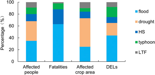
FIGURE 1. Annual average percentage losses caused by floods, droughts, HSs, typhoons, and LTFs to the total losses during 2001–2020.
In the last two decades, all losses caused by major MDs in China showed a significant decreasing trend, except for DELs (Table 1). The population affected by each MD showed a significant reduction. Drought had the greatest impact on the reduction of the affected population, followed by floods. The population killed by each meteorological hazard also showed a decreasing trend. HSs and floods had a significant impact on the decreasing trend of fatalities. Except for typhoons, the crop area affected by each meteorological hazard showed a decreasing trend, and prominently caused by droughts. The DELs caused by floods and typhoons showed an increasing trend. In contrast, the DELs caused by drought, HSs, and LTFs showed a decreasing trend.
Regarding the contribution of various MDs to the total losses, the impact of floods on DELs increased significantly (Table 2). The percentage of losses caused by typhoons increased, except for fatalities, and the affected crop area percentage increased significantly. HSs showed a decreasing impact on all losses, except for the affected crop area, and the percentage of DELs decreased significantly. The impact of drought and LTFs decreased, and the percentage of DELs caused by drought reduced significantly.

TABLE 2. Trend in the percentage of losses caused by various MDs to the total losses during 2001–2020 (unit: %/year).
On the national scale, floods were the leading MDs causing the most severe losses in China, followed by droughts. Droughts and floods were also important factors determining the long-term trends in MD losses. Floods and typhoons showed positive contributions to the trend in MD losses, whereas droughts, LTFs, and HSs showed negative contributions.
3.1.2 Spatial variations
The populations affected by MDs were concentrated in central China. The annual mean affected population in Sichuan, Hunan, Hubei, Anhui, and Henan exceeded 18 million, among which the largest affected population in Sichuan exceeded 24 million (Figure 2A). In Yunnan, Guizhou, and most parts of northern China, except Xinjiang, populations were mainly affected by drought. In terms of the affected population, flooding was the primary MD in most of the Yangtze River basin and Guangxi, and the impact of typhoons dominated in southeastern China.
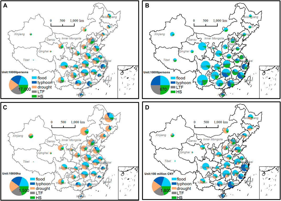
FIGURE 2. Percentage of (A) affected population, (B) fatalities, (C) affected crop area, and (D) direct economic losses caused by MDs to the total in China during 2001–2020 (the area of the circles represents the value of losses).
The fatalities were distributed over a large meridional gradient, with higher values in the south and lower values in the north. The annual mean fatalities in Yunnan, Sichuan, Guizhou, Gansu, Hunan, Hubei, Guangxi, Guangdong, and Fujian exceeded 80, with the maximum in Yunnan exceeding 200 (Figure 2B). Fatalities in most parts of China were mainly caused by floods. However, the fatalities in Zhejiang, Fujian, and Guangdong were mainly induced by typhoons, and those in Shandong, Jiangsu, Shanghai, Anhui, Jiangxi, Hainan, and Tianjin were mainly attributed to HSs.
The affected crop area in Northeast China, North China, and the lower reaches of the Yellow River basin was larger than that in other regions. The yearly average affected crop area in Inner Mongolia, Heilongjiang, Hebei, Shandong, Henan, Hubei, and Hunan exceeded 1.6 million ha, with the maximum in Heilongjiang exceeding 3 million ha (Figure 2C). The affected crop area in most parts of China was predominantly caused by drought. However, the crop areas in Jiangsu, Anhui, Hubei, Hunan, and Jiangxi were mainly affected by floods, while those in Shanghai, Zhejiang, Fujian, Guangdong, and Hainan were mainly affected by typhoons. The affected crop area in Xinjiang was mainly induced by HSs.
DELs caused by MDs were much more prominent in the Yangtze River basin than those in other regions. The annual mean DELs exceeded 20 billion yuan in Zhejiang, Hunan, Guangdong, and Sichuan, with the highest DEL exceeding 26 billion yuan in Hunan (Figure 2D). Floods were the primary disaster causing a significant amount of DELs in most parts of China. The DELs in Inner Mongolia, Shanxi, Liaoning, Qinghai, and Ningxia were mainly caused by drought, while those in Shanghai, Zhejiang, Fujian, Guangdong, and Hainan were mainly induced by typhoons. The DELs in Xinjiang were mainly caused by HSs.
Except for Tibet and Liaoning, the affected populations in most parts of China showed decreasing trends, which were significant in most parts of central and eastern China. The decreasing trends in Sichuan and Guangxi were more than 1 million people per year (Figure 3A). Drought was the main MD influencing the affected population trends in most parts of China. LTF contributed greatly to the affected population trend in Xinjiang, Qinghai, and Hunan. The trends in affected population in Jiangsu, Anhui, Guangxi, and Tibet were primarily caused by floods, while those in southeastern China, including Shanghai, Zhejiang, Fujian, Guangdong, and Hainan, were mainly induced by typhoons.
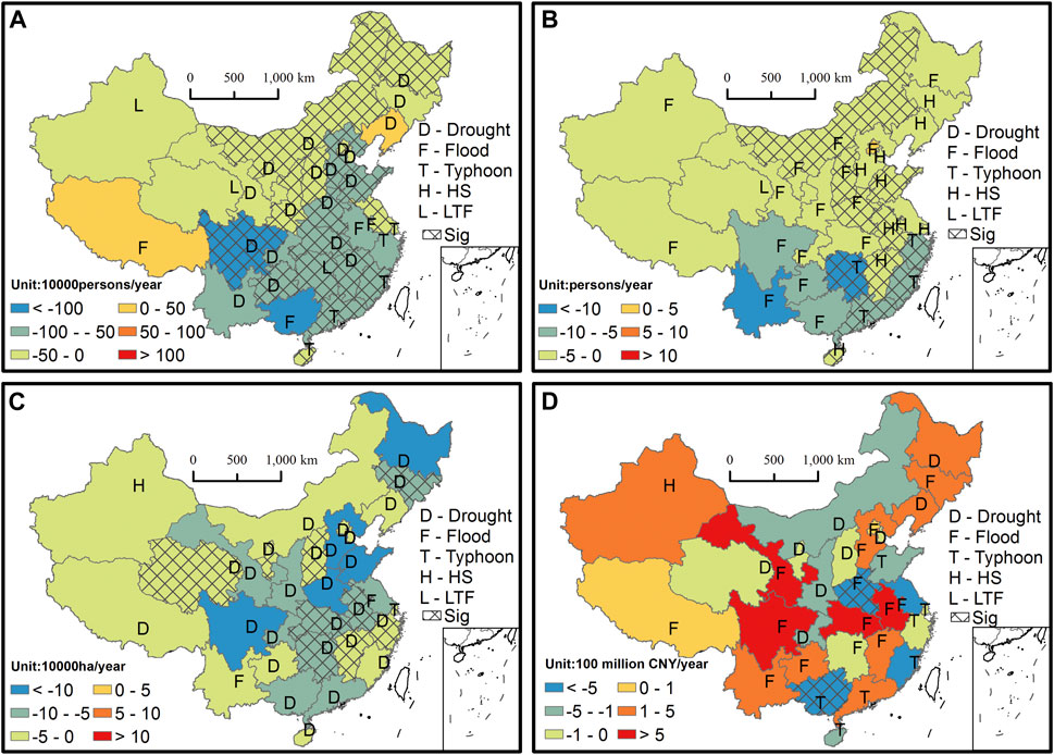
FIGURE 3. Distribution in the trend of (A) affected population, (B) fatalities, (C) affected crop area, and (D) DELs caused by MDs in China. (D) denotes droughts, (F) denotes floods, (H) denotes HSs, (L) denotes LTFs, (T) denotes typhoons, and the crossed areas denote the trends exceeding a confidence level of 95%).
Except for Beijing, most parts of China showed a decreasing trend in fatalities. The decreasing trend was greater in southern China than that in the north, with the decreasing trends in Yunnan and Hunan exceeding ten people per year (Figure 3B). On 21 July 2012, heavy rainfall and floods in Beijing caused 79 deaths. If the deaths from this extreme event are excluded, the fatalities in Beijing also showed a decreasing trend. The trends in fatalities in most of China were due to floods. The decreasing fatality trends in Jilin, Liaoning, Tianjin, Hebei, Shandong, Jiangsu, Anhui, Shanghai, Jiangxi, and Hainan were mainly affected by HSs. Typhoons mainly caused a decreasing trend in fatalities in Zhejiang, Fujian, Guangdong, and Hunan. Moreover, the trend in fatalities in Qinghai was mainly affected by LTFs.
The affected crop area showed a decreasing trend in all provinces, among which the affected crop area in Heilongjiang, Hebei, Shandong, Henan, and Sichuan decreased by more than 1 million hectares per year (Figure 3C). The affected crop area was significantly reduced by drought in the lower and middle reaches of the Yangtze River basin, Jilin, Shanxi, and Qinghai. The reduction in crop-affected areas in Xinjiang was mainly affected by HSs. The trends in affected crop areas in Jiangsu and Yunnan were primarily influenced by floods, while those in Shanghai were mainly affected by typhoons.
DELs showed increasing trends in Northeast China, Hebei, Anhui, Hubei, Jiangxi, Guangdong, Guizhou, Yunnan, Sichuan, Gansu, Xinjiang, and Tibet, as well as significant decreasing trends in Henan and Guangxi (Figure 3D). Floods were the dominant disaster causing prominent trends in DELs in most parts of China. In Heilongjiang, Liaoning, Inner Mongolia, Tianjin, Shanxi, Shaanxi, Ningxia, Qinghai, and Chongqing, DEL trends were mainly affected by drought. The trend in DELs in Xinjiang was mainly affected by HSs. Typhoons had a dominant influence on the DEL trends in Shanghai, Zhejiang, Fujian, Shandong, Guangdong, Guangxi, and Hainan.
Overall, the yearly average and long-term trends in MD losses exhibited regional heterogeneity and were subject to different dominant hazards in different regions. The trends in affected population and crop area were greatly influenced by drought. The fatalities and DELs were dominated by floods. In southeastern China, disaster losses and their trends were mainly determined by typhoons.
3.2 Spatiotemporal Variations in Vulnerability
3.2.1 Spatial Patterns and Temporal Variations
The yearly average rate of the affected population to the total population was greater in the central region than in the coastal and western regions, with a rate exceeding 40% in Gansu and Guizhou and less than 5% in Beijing, Tianjin, and Shanghai (Figure 4A). Except for Liaoning, all provinces showed a decreasing trend in the affected population rates, and most of the provinces in central and eastern China showed a significant downward trend. The population vulnerability per 5 years showed a slight increase, followed by a significant decrease (Figure 4B). The affected population fluctuated around 400 million from 2001 to 2011 and decreased sharply from 2012 to 2020. The decreasing trend of the affected population ratio was mainly affected by the number of affected people. The yearly average affected population in China was more than 300 million before 2016, which decreased by ∼60% to only 148.5 million after 2016. Moreover, population exposure has experienced a relatively steady and slow growth.
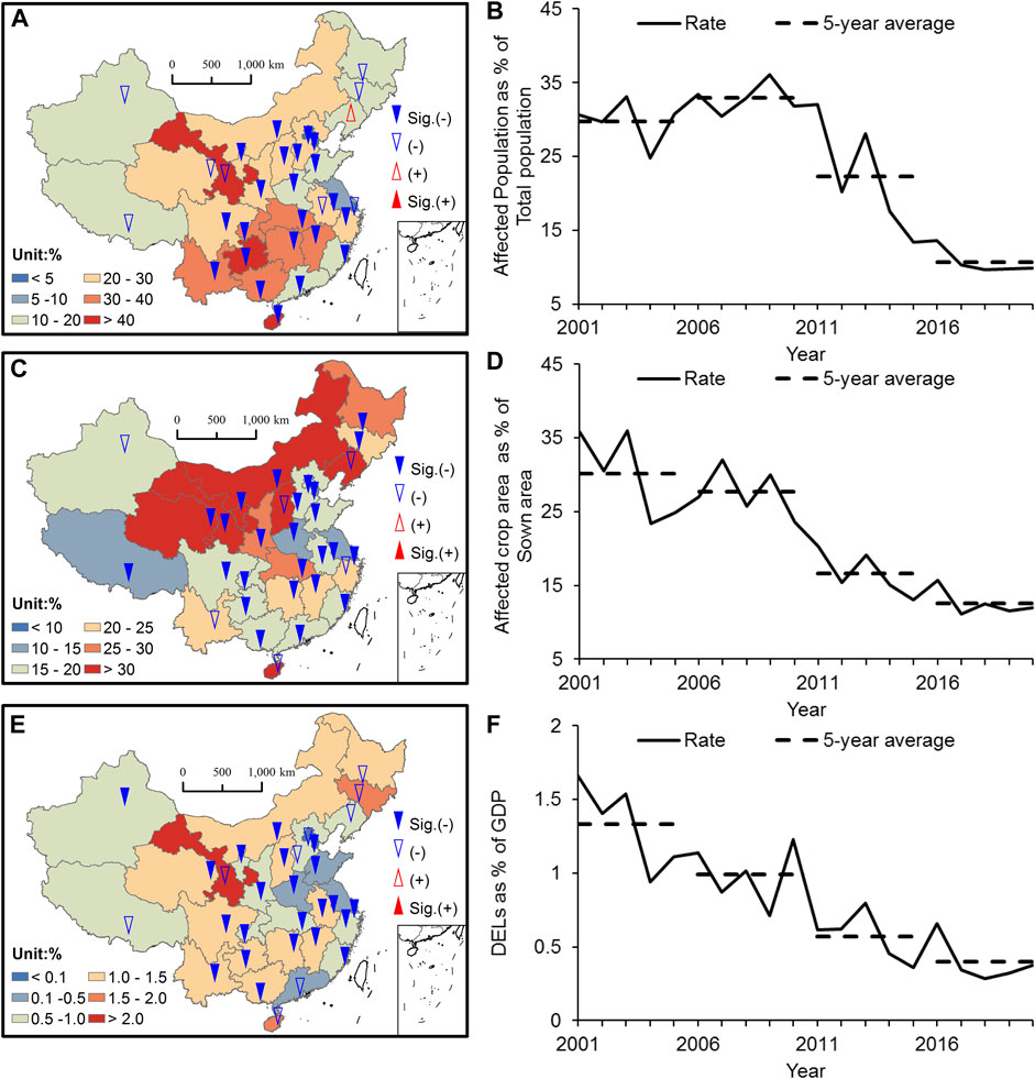
FIGURE 4. Spatial distribution of averages and trends (A) and temporal changes (B) in the affected population rate; (C) and (D) are the same as (A) and (B), but for the affected crop area rate; (E) and (F) are the same as (A) and (B), but for the direct economic loss rate. In the spatial distribution maps, the colored shaded areas are the averages, the blue (red) triangles are the decreasing (increasing) trends, and the solid triangles indicate a confidence level exceeding 95%. A 5-year average in each period was calculated at each rate and is indicated by the black dashed lines.
The rates of the affected crop area to the sown area in the north were larger than those in the south and exceeded 30% in Shanxi, Inner Mongolia, Gansu, Liaoning, Qinghai, and Ningxia (Figure 4C). The rate in Shanghai was only 5.2%, which may be attributed to its small sown area. The affected crop area rates of most provinces in China showed significant decreasing trends, except for Liaoning, Shanxi, Yunnan, Zhejiang, and Xinjiang. The national average affected crop area rate showed a significant decreasing trend over the past 20 years (Figure 4D). The change in the sown area in China was not apparent in the past 20 years. However, the average affected crop area per 5 years decreased significantly. The yearly mean affected crop area in China was more than 40 million hectares before 2011, which decreased by 46% to less than 30 million hectares after 2011.
The rates of DELs to GDP were greater in the central region than those in the coastal and western regions, with the rates exceeding 2% in Gansu and less than 0.1% in Beijing, Tianjin, and Shanghai (Figure 4E). All provincial DEL rates showed decreasing trends, and most had a significance level of 0.05, except for Heilongjiang, Jilin, Liaoning, Hebei, Tibet, and Guangdong. The decreasing trend in the annual averaged DELs was mainly attributed to the variations in GDP (Figure 4F). In the last 20 years, China has experienced significant growth in GDP, while the change in DELs has been relatively small. Thus, the vulnerability of the economy has been significantly reduced.
3.2.2 Relationship Between Vulnerability and Economic Development
Vulnerability is strongly linked to economic growth and the disaster risk reduction (DRR) efforts that have been adopted. These measures are thought to increase as income levels rise and the capacity for risk management improves. Thus, GDP is generally considered to be related to vulnerability. A higher GDP per capita allows for more investment in disaster risk management, which can increase resilience to disaster risk and reduce vulnerability (Zhou et al., 2014; Qin et al., 2015; Hallegatte, 2017). Furthermore, we explored the relationship between vulnerability and GDP per capita by assessing the rate of the affected population to the total population, the rate of affected crop area to the sown area, and the rate of DELs to GDP.
Figure 5 shows the relationship between the total population and the affected population caused by each subtype of MD. A significant positive correlation between them indicates that the affected population increases significantly with an increase in exposure (Figure 5A). Only Jiangsu had high population exposure and low losses. The per capita GDP of Beijing, Shanghai, Tianjin, Chongqing, Inner Mongolia, Shandong, Jiangsu, Hubei, Zhejiang, Fujian, and Guangdong exceeds the national average, which means that these regions are economically developed. The proportion of the affected population to the total population in these regions was significantly less than that in other regions, indicating relatively low population vulnerability in these regions.
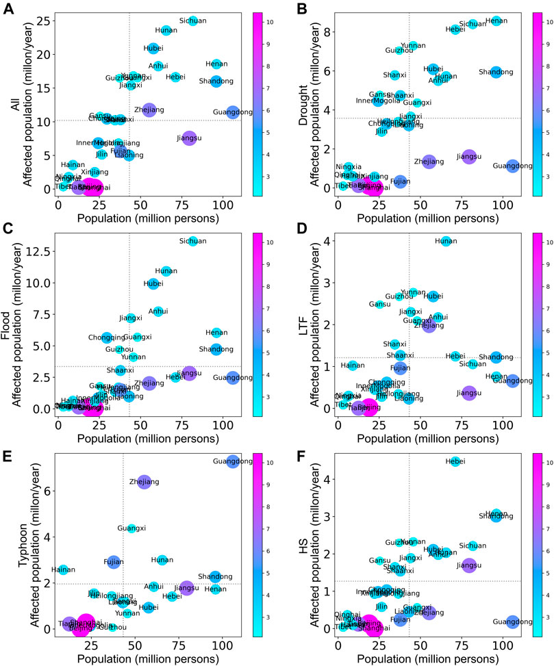
FIGURE 5. Relationship between total population and affected population caused by (A) all MDs, (B) droughts, (C) floods, (D) LTFs, (E) typhoons, and (F) HSs, in which the area and shaded color of the bubbles represent the GDP per capita (unit: 10 thousand CNY per person), the horizontal dotted lines denote the average value of the affected population, and the vertical dotted lines denote the average value of the provincial population.
Under the influence of droughts and floods, we observed a significant positive correlation between the affected population and the total population (Figures 5B, C). This suggests that the affected population was significantly influenced by the exposure of the population. In contrast, population vulnerability in economically developed regions was significantly lower than that in other regions. Population vulnerability was higher in Chongqing and Guizhou under the impact of floods. The correlation between the population affected by LTFs and the total population was positive and insignificant. The population vulnerability in economically developed areas was lower than that in other regions under the influence of LTFs (Figure 5D). The population affected by typhoons had a significant positive correlation with the total population, while the effect of economic development on population vulnerability was not significant (Figure 5E). In China, Hainan and Fujian are highly prone to typhoon hazards, with higher population vulnerability relative to other regions. The population affected by HSs was also significantly positively correlated with the total population (Figure 5F). Population vulnerability was lower in economically developed regions than in other regions under the influence of HSs. Population vulnerability was higher in Guizhou, Gansu, Shaanxi, and Shanxi under the impact of droughts, LTFs, and HSs.
The affected crop area and sown area showed a significant positive correlation, and the level of economic development had less influence on crop vulnerability than population vulnerability (Figure 6A). The average sown area in each province over the last two decades was used as an indicator of crop exposure, and the average provincial affected crop area was used as an indicator of disaster risk. Jiangsu showed high exposure and low disaster risks for crops. The crop area affected by droughts, floods, LTFs, and HSs was significantly and positively correlated with the sown area, indicating that increased exposure leads to a significant increase in the affected crop area (Figures 6B–D, F). Under the influence of droughts, crop vulnerability was high in Shanxi, Shaanxi, Liaoning, and Gansu (Figure 6B). The affected crop area in Inner Mongolia was close to that in Heilongjiang; however, the sown area in Inner Mongolia was much smaller than that in Heilongjiang. The high crop vulnerability in Inner Mongolia was mainly attributed to its geographical location at the intersection of agriculture and animal husbandry, with a more fragile ecological environment. The regional disparity in crop vulnerability was small under the influence of floods (Figure 6C). Crop vulnerability was high in Gansu, Shanxi, Shaanxi, and Xinjiang under the influence of LTFs and HSs (Figures 6D, F). The positive correlation between the crop area affected by typhoons and the sown area was not significant. Crop vulnerability was also high in Guangdong, Zhejiang, Fujian, Hainan, where typhoons occur frequently (Figure 6E).
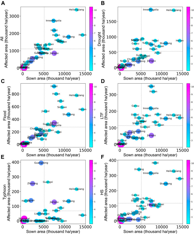
FIGURE 6. Content is the same as that in Figure 5, but for the relationship between sown area and affected crop area.
The total DELs caused by MDs had a significant positive correlation with GDP (Figure 7A). Gansu’s economic vulnerability was 2.1% and the largest among the 31 provinces, which may be due to the increasing influence of floods. The average GDP of each province in the last two decades was used as an indicator of economic exposure, and the average provincial DEL was used as an indicator of economic disaster risk. Beijing, Shanghai, and Jiangsu showed high economic exposure and low economic disaster risk. The correlations between GDP and DELs caused by droughts, floods, LTFs, and HSs were insignificant. The economic vulnerability in the economically developed region was lower than that in other regions (Figures 7B–D, F). The economic vulnerability to drought was high in Northeast China as well as in Yunnan, Guizhou, and Shanxi (Figure 7B). The economic vulnerability in Jiangxi, Shanxi, Jilin, and Guangxi was high under the influence of floods (Figure 7C). The economic vulnerability to LTFs was high in Gansu, Shanxi, Shaanxi, Jiangxi, Guangxi, Guizhou, and Yunnan (Figure 7D). The correlation index between typhoon-induced DELs and GDP was 0.5, which was significant at the 95% confidence level (Figure 7E). This suggests that economic exposure had an important influence on the DELs. In China, typhoons occurred most frequently in Guangdong over the last 20 years, followed by Fujian and Hainan. However, the yearly average DELs were the largest in Zhejiang, which may be due to its larger economic exposure. Economic vulnerability to typhoons was high in Guangxi and Hainan and showed no significant relationship with the level of economic development. Xinjiang, Inner Mongolia, Shanxi, Shaanxi, Gansu, Yunnan, Heilongjiang, and Jiangxi showed high economic vulnerability to HSs (Figure 7F).
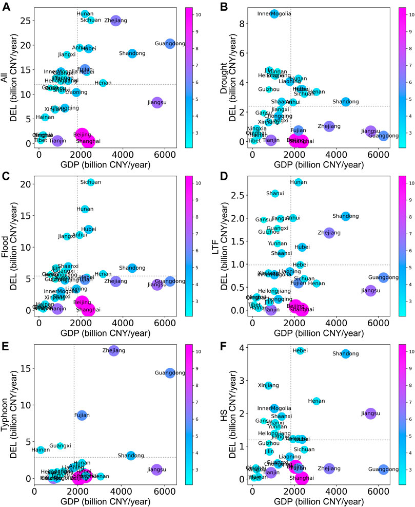
FIGURE 7. Contents are the same as that in Figure 5, but for the relationship between GDP and DELs.
4 Conclusion and Discussion
We analyzed the spatiotemporal characteristics of MD losses at the provincial level in China during 2001–2020 to determine the vulnerability of the population, agriculture, and economy, as well as to disclose their relationships with regional economic development. From 2001 to 2020, major MDs in China affected an average of 316.3 million people and 34.3 million hectares of crops per year, caused 1,739 deaths, and costed 372.3 billion yuan in DELs. Floods and droughts were major MDs that affected the population in China. The fatalities and DELs were mainly affected by floods, contributing 63% and 44% to the total MD losses, respectively. The affected crop area was mainly induced by drought, contributing 48% to the total affected crop area. In the past 20 years, MD losses, except for DELs, have decreased significantly. Losses induced by droughts, HSs, and LTFs all showed decreasing trends, while DELs induced by floods and typhoons as well as typhoon-affected crop areas showed an increasing trend. Floods and typhoons have contributed positively to the trend in most MD losses, which means that the influence of these two disasters has become increasingly important in the last 20 years.
The affected population was concentrated in central China, with a maximum annual average value of 24 million in Sichuan. The affected population in central China was mainly affected by floods, while that in most of northern China was mainly affected by drought. The significant decreasing trend of the affected population in most parts of central and eastern China was dominated by drought. Fatalities were fewer in the north while more in the south. Fatalities and their trends in most parts of China were mainly induced by floods. HS was the primary factor for the significant decrease in fatalities in most of eastern China. The affected crop area was higher in the north than that in the south. The significant decreasing trend in the affected crop area in the middle and lower reaches of the Yangtze River, Jilin, Shanxi, and Qinghai was mainly attributed to drought. Floods were the most impactful disasters, causing the highest DELs in most parts of China. The DEL trends in most parts of China were not significant, except for those in Henan and Guangxi. The significant decreasing trend of DELs in Henan was mainly affected by floods, while the significant decreasing trend in Guangxi was mainly induced by typhoons.
The vulnerability of the population, crops, and economy tended to decrease. MD losses were influenced by both exposure and vulnerability, as well as the level of economic development. The affected population, crop area, and DELs were all significantly and positively correlated with exposure. Economic development reduced the vulnerability of the population and economy but had no significant effect on the vulnerability of crops.
The IPCC report states that residual risk cannot be avoided (IPCC, 2014); in other words, the risk cannot be entirely eliminated to zero. Although the risk is difficult to quantify, it can still be reduced through a series of engineering and non-engineering measures. Our study shows that vulnerability declines with the level of economic development. This indicates a more urgent need to implement DRR measures in less-developed areas to minimize disaster losses and reduce disaster risks effectively. In general, the dominant MD losses exhibited various characteristics which differed regionally. Economic development had different influences on the vulnerability of different disaster-bearing bodies. Therefore, formulating different policies according to local disaster prevention and mitigation efforts is necessary.
Under the background of global climate change, the characteristics of MDs in China have also changed significantly. Drought and flood had the dominant influences in China among all MDs. China experienced a significant wetting trend at annual and seasonal scales during 1961–2009 (Wang et al., 2017). The humid region in southeastern China showed increased precipitation, while drying trends mainly occurred in the transition regions between the humid and arid regions of China (Chen et al., 2017). TCs making landfall over East China have tended to be more destructive in recent decades (Li et al., 2017). In southeastern China, total annual TC precipitation increased significantly owing to increased precipitation frequency and precipitation intensity per TC from 1980 to 2017 (Liu and Wang, 2020). The annual precipitation induced by landfall TCs also showed a noticeable northward shift. According to the results of this study, the percentage of losses induced by floods and typhoons, except for fatalities, to total losses showed an increasing trend, and that of drought showed a decreasing trend in the last 20 years. In particular, although the typhoon-induced losses increased with exposure, the losses were largely affected by the intensity and scope of the typhoon disasters. Focus should be placed on the predictions and early warnings of typhoons and floods, especially in regions with increasing influence, such as southeastern China.
Data Availability Statement
The original contributions presented in the study are included in the article/Supplementary Material; further inquiries can be directed to the corresponding author.
Author Contributions
YL and SZ contributed to the conception and design of the study, organized the database, performed the statistical analysis, and wrote the first draft of the article. YL, SZ, and GW revised the article. All authors contributed to manuscript revision, and read and approved the submitted version.
Funding
This work was jointly funded by the National Key Research and Development Program of China (2019YFC1510205 and 2018YFC1509007) and the National Natural Science Foundation of China (41875120).
Conflict of Interest
The authors declare that the research was conducted in the absence of any commercial or financial relationships that could be construed as a potential conflict of interest.
The handling editor declared a shared affiliation with the authors (YL, SZ, and GW) at the time of review.
Publisher’s Note
All claims expressed in this article are solely those of the authors and do not necessarily represent those of their affiliated organizations, or those of the publisher, the editors, and the reviewers. Any product that may be evaluated in this article, or claim that may be made by its manufacturer, is not guaranteed or endorsed by the publisher.
References
Chen, T., Zhang, H., Chen, X., Hagan, D. F., Wang, G., Gao, Z., et al. (2017). Robust Drying and Wetting Trends Found in Regions over China Based on Koppen Climate Classifications. J. Geophys. Res. Atmos. 122, 4228–4237. doi:10.1002/2016JD026168
CMA (2020). Yearbook of Meteorological Disasters of China. Beijing, China: China Meteorological Press.
Cutter, S. L., and Finch, C. (2008). Temporal and Spatial Changes in Social Vulnerability to Natural Hazards. Proc. Natl. Acad. Sci. 105, 2301–2306. doi:10.1073/pnas.0710375105
Ge, Y., Dou, W., Wang, X., Chen, Y., and Zhang, Z. (2021). Identifying Urban-Rural Differences in Social Vulnerability to Natural Hazards: a Case Study of China. Nat. Hazards. 108, 2629–2651. doi:10.1007/s11069-021-04792-9
Geiger, T., Frieler, K., and Levermann, A. (2016). High-income Does Not Protect against hurricane Losses. Environ. Res. Lett. 11, 084012. doi:10.1088/1748-9326/11/8/084012
Hallegatte, S. (2017). A Normative Exploration of the Link between Development, Economic Growth, and Natural Risk. EconDisCliCha 1, 5–31. doi:10.1007/s41885-017-0006-1
Han, W., Liang, C., Jiang, B., Ma, W., and Zhang, Y. (2016). Major Natural Disasters in China, 1985-2014: Occurrence and Damages. Ijerph 13, 1118. doi:10.3390/ijerph13111118
Huang, D., Zhang, R., Huo, Z., Mao, F., E, Y., and Zheng, W. (2012). An Assessment of Multidimensional Flood Vulnerability at the Provincial Scale in China Based on the DEA Method. Nat. Hazards. 64, 1575–1586. doi:10.1007/s11069-012-0323-1
IPCC (2014). Climate Change 2014: Impacts, Adaptation, and Vulnerability. Cambridge: Cambridge University Press. Available at: http://www.ipcc.ch/report/ar5/wg2/.
IPCC (2012). “Determinants of Risk: Xxposure and Vulnerability,” in Managing the Risks of Extreme Events and Disasters to advance Climate Change Adaptation. A Special Report of Working Groups I and II of the Intergovernmental Panel on Climate Change (IPCC). Editor C. B. Field (Cambridge: Cambridge University Press), 65–108.
IPCC (2021). Climate Change 2021: The Physical Science Basis. Cambridge: Cambridge University Press, In press.
Jiao, M. Y., Song, L. C., Jiang, T., Zhang, D., and Zhai, J. Q. (2015). China's Implementation of Impact and Risk-Based Early Warning. WMO Bull. 64, 9–12.
Jongman, B., Winsemius, H. C., Aerts, J. C. J. H., Coughlan de Perez, E., van Aalst, M. K., Kron, W., et al. (2015). Declining Vulnerability to River Floods and the Global Benefits of Adaptation. Proc. Natl. Acad. Sci. U.S.A. 112, E2271–E2280. doi:10.1073/pnas.1414439112
Jonkman, S. N. (2005). Global Perspectives on Loss of Human Life Caused by Floods. Nat. Hazards. 34, 151–175. doi:10.1007/s11069-004-8891-3
Kellenberg, D. K., and Mobarak, A. M. (2008). Does Rising Income Increase or Decrease Damage Risk from Natural Disasters? J. Urban Econ. 63, 788–802. doi:10.1016/j.jue.2007.05.003
Li, R. C. Y., Zhou, W., Shun, C. M., and Lee, T. C. (2017). Change in Destructiveness of Landfalling Tropical Cyclones over China in Recent Decades. J. Clim. 30, 3367–3379. doi:10.1175/JCLI-D-16-0258.1
Liu, L., and Wang, Y. (2020). Trends in Landfalling Tropical Cyclone-Induced Precipitation over China. J. Clim. 33, 2223–2235. doi:10.1175/JCLI-D-19-0693.1
Peduzzi, P., Dao, H., Herold, C., and Mouton, F. (2009). Assessing Global Exposure and Vulnerability towards Natural Hazards: the Disaster Risk Index. Nat. Hazards Earth Syst. Sci. 9, 1149–1159. doi:10.5194/nhess-9-1149-2009
Qin, D. H. (2015). China National Assessment Report on Risk Management and Adaptation of Climate Extremes and Disasters. Beijing, China: Science Press.
Shi, J., Cui, L., and Tian, Z. (2020). Spatial and Temporal Distribution and Trend in Flood and Drought Disasters in East China. Environ. Res. 185, 109406. doi:10.1016/j.envres.2020.109406
Tanoue, M., Hirabayashi, Y., and Ikeuchi, H. (2016). Global-scale River Flood Vulnerability in the Last 50 Years. Sci. Rep. 6, 36021. doi:10.1038/srep36021
Turner, B. L., Kasperson, R. E., Matson, P. A., Mccarthy, J. J., Corell, R. W., Christensen, L., et al. (2003). A Framework for Vulnerability Analysis in Sustainability Science. Pnas 100, 8074–8079. doi:10.1073/pnas.1231335100
Wang, Y., Chao, G., Wang, A., Wang, Y., Zhang, F., Zhai, J., et al. (2014). Temporal and Spatial Variation of Exposure and Vulnerability of Flood Disaster in China. Clim. Change Res. 11, 391–398.
Wang, Y., Zhang, X. M., Zhou, N. F., Hu, Z. G., Li, J. Y., Lv, Y., et al. (2021). Evolution Characteristics of Global Meteorological and Hydrological Disasters from 1990 to 2019. Tans. Atmos. Sci. 44, 496–506. doi:10.13878/j.cnki.dqkxxb.20210107001
Wang, Z., Li, J., Lai, C., Zeng, Z., Zhong, R., Chen, X., et al. (2017). Does Drought in China Show a Significant Decreasing Trend from 1961 to 2009? Sci. Total Environ. 579, 314–324. doi:10.1016/j.scitotenv.2016.11.098
Wu, J., Fu, Y., and Zhang, J. (2014). Meteorological Disaster Trend Analysis in China: 1949-2013. J. Nat. Resour. 29, 1520–1530. doi:10.11849/zrzyxb.2014.09.007
Wu, J., Han, G., Zhou, H., and Li, N. (2018). Economic Development and Declining Vulnerability to Climate-Related Disasters in China. Environ. Res. Lett. 13, 034013. doi:10.1088/1748-9326/aaabd7
Wu, J., Li, Y., Ye, T., and Li, N. (2019). Changes in Mortality and Economic Vulnerability to Climatic Hazards under Economic Development at the Provincial Level in China. Reg. Environ. Change 19, 125–136. doi:10.1007/s10113-018-1386-7
Xu, X., and Tang, Q. (2021). Meteorological Disaster Frequency at Prefecture-Level City Scale and Induced Losses in mainland China during 2011-2019. Nat. Hazards. 109, 827–844. doi:10.1007/s11069-021-04858-8
Zhang, Q., Wu, L., and Liu, Q. (2009). Tropical Cyclone Damages in China 1983-2006. Bull. Amer. Meteorol. Soc. 90, 489–496. doi:10.1175/2008BAMS2631.1
Zhao, S. S., Gao, G., Huang, D. P., and He, W. P. (2017). Characteristics of Meteorological Disaster Losses in China from 2004 to 2013. J. Meteorology Environ. 33, 101–107. doi:10.3969/j.issn.1673-503X.2017.01.014
Zhou, Y., Li, N., Wu, W., and Wu, J. (2014). Assessment of Provincial Social Vulnerability to Natural Disasters in China. Nat. Hazards. 71, 2165–2186. doi:10.1007/s11069-013-1003-5
Keywords: meteorological disaster, disaster losses, vulnerability, economic development, spatiotemporal variations
Citation: Li Y, Zhao S and Wang G (2021) Spatiotemporal Variations in Meteorological Disasters and Vulnerability in China During 2001–2020. Front. Earth Sci. 9:789523. doi: 10.3389/feart.2021.789523
Received: 05 October 2021; Accepted: 17 November 2021;
Published: 14 December 2021.
Edited by:
Bo Lu, China Meteorological Administration, ChinaReviewed by:
Yanjun Wang, Nanjing University of Information Science and Technology, ChinaSaini Yang, Beijing Normal University, China
Copyright © 2021 Li, Zhao and Wang. This is an open-access article distributed under the terms of the Creative Commons Attribution License (CC BY). The use, distribution or reproduction in other forums is permitted, provided the original author(s) and the copyright owner(s) are credited and that the original publication in this journal is cited, in accordance with accepted academic practice. No use, distribution or reproduction is permitted which does not comply with these terms.
*Correspondence: Shanshan Zhao, emhhb3NzQGNtYS5nb3YuY24=
 Ying Li
 Shanshan Zhao
 Guofu Wang1