 M. Santonja1,2*
 A. Pérez-González2
 J. Baena3
 J. Panera2,4
 E. Méndez-Quintas2,5*D. Uribelarrea2,6
 M. Demuro7
 L. Arnold7
 A. Abrunhosa1,8S. Rubio-Jara1,2,4
- 1Centro Nacional de Investigación Sobre la Evolución Humana (CENIEH), Burgos, Spain
- 2Instituto de Evolución en África (IDEA), Madrid, Spain
- 3Department of Prehistory and Archaeology, Autonomous University of Madrid (Campus Cantoblanco), Madrid, Spain
- 4Departamento de Prehistoria, Historia Antigua y Arqueología, Universidad Complutense de Madrid, Madrid, Spain
- 5Grupo de Estudos de Arqueoloxía, Antigüidade e Territorio (GEAAT), University of Vigo, Ourense, Spain
- 6Geodynamics, Stratigraphy and Palaeontology Department (GEODESPAL), Complutense University of Madrid, Madrid, Spain
- 7School of Physical Sciences, Environment Institute, Institute for Photonics and Advanced Sensing (IPAS), University of Adelaide, Adelaide, SA, Australia
- 8Interdisciplinary Center for Archaeology and Evolution of Human Behaviour (ICArEHB), Universidade do Algarve, Faro, Portugal
In the upper basin of the Guadiana River, especially in the sectors drained by its right-bank tributaries, the Bullaque and Becea rivers, important concentrations of Acheulean and Mousterian industries can be found in a superficial position. These industries have provided series containing tens of thousands of pieces. Deposits in stratigraphic position have also been identified, related to the fluvial terraces of the Guadiana and Jabalón rivers and some tributaries. Within the sector studied, in the province of Ciudad Real, the position of these deposits is related to alluvial fans developed on the slopes of the immediate reliefs. These fans, mainly composed of Lower and Middle Ordovician quartzite gravel, were eroded in their distal positions by the Bullaque and Becea rivers, forming very low terraces on which large concentrations of Acheulean and Mousterian lithic industry can be found. El Sotillo, the only known stratigraphic site in the area, was excavated in 2017–2019 and consists of several levels with Mousterian and Acheulean industry. We present the technological characteristics of the main Acheulean assemblage recognised at this site, for which numerical dates have been obtained placing its chronology in the second half of the Middle Pleistocene. The location of these sites, in surficial position and El Sotillo, allows us to recognise a territorial space with specific geographic characteristics and a very significant human impact.
1 Introduction
The upper course of the Guadiana river - inland Iberian Peninsula- (Figure 1), in the Paleozoic regions of the south-eastern Montes de Toledo and the volcanic territory of Campo de Calatrava, has one of the highest concentrations of Acheulean and Mousterian sites of the Atlantic drainage basins of the Iberian Peninsula. Most of them are surface sites (Vallespí et al., 1979 and 1985; Santonja and Villa, 2006), although some are in stratigraphic position (Santonja and Pérez-González, 2002), among which the site of El Sotillo, excavated in 2017–2019, stands out. Research carried out in recent years has focused on some of the few sites with series of lithic industries in stratigraphic position and includes a detailed study of the composition and technical features of the lithic industry. Our contribution includes a morphological and sedimentological characterisation of the fluvial and alluvial deposits bearing archaeological artefacts in order to understand some “taphonomic” features of the archaeological site.
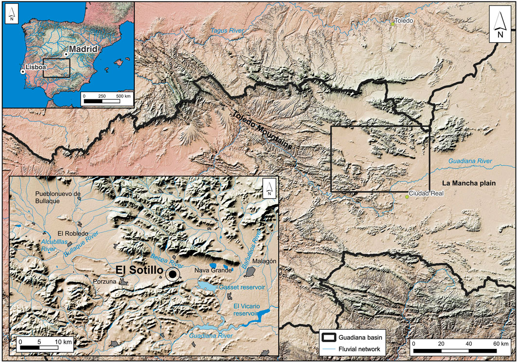
FIGURE 1. Location of El Sotillo in the central-southwestern area of the Iberian Peninsula, and in the south-eastern sector of Montes de Toledo. In the bottom-left inset, the Acheulean site of El Sotillo is framed to the north and south by Palaeozoic hills with quartzite rocks, in the Porzuna-Malagón depression. Map made with data layers provided by the CNIG.
In the regions of Montes de Toledo and Campo de Calatrava, both in the Guadiana basin, the fluvial networks and their terraces had barely fit in the landscape during their evolution throughout the Quaternary; highlighting the quartzite reliefs and their slopes covered with screes and extensive alluvial fans at the foot of the hills. The surficial Palaeolithic assemblages are a constant feature of the landscape of these regions (Santonja, 1976; Santonja and Pérez-González, 2002). The characteristics of these sites are relatively homogeneous, with a series in which cores and knapped products largely dominate, and a negligible component of shaped and retouched tools. The clearly recognized Levallois technology has been fundamental in identifying several of these sites as Middle Palaeolithic, although the difficulties in establishing chronologies or in identifying functional aspects have led to little interest in their study, despite some notable works (Martín Blanco et al., 1995; Jiménez et al., 1996).
In the locality of Porzuna, within our study area (Figure 1), an important group of sites on the +5 m terrace of the Bullaque River has been studied. In this area, a series of tens of thousands of quartzite pieces were previously collected on the surface, with some of them being conserved in the Museum of Ciudad Real, including heterogeneous materials from the Acheulean and Mousterian periods (Vallespí et al., 1979 and 1985). Another unique singular site is El Sotillo, at Malagón (Figure 1). This site displays complex stratigraphy, identified in 1983 by local researchers and mentioned in subsequent studies (Ciudad Serrano 1986; Santonja and Pérez-González 2002; Gómez Laguna et al., 2010; Arroyo and de la Torre, 2013; Arroyo et al., 2019).
There are other known -not studied here- Acheulean sites in stratigraphic position on the fluvial terraces of the Guadiana and Jabalón rivers. In the area where these river courses meet, a system of terraces has been recognised at levels of +45–50 m, +40–43 m, +31–33 m, +25-27, +19–21 m, +10–12 m, +7 m and +2–3 m (Pérez-González, 1982). The levels, at +10–12 m and +7 m, contain Acheulean industrial assemblages at different points along both rivers (Santonja 1981; Santonja and Pérez-González 2002; 2010).
In order to extend our knowledge of the regional Palaeolithic, between 2017 and 2019, we carried out three excavation seasons at the El Sotillo site. These allowed us to identify two levels with Acheulean lithic industry and another with Mousterian lithic industry, all three with no preserved fauna. In 2021, our work focused on the municipality of Porzuna, to verify whether any Acheulean or Mousterian industry was present at the sites in a stratigraphic position and to define the position of the sites from a morpho-stratigraphic perspective.
2 The Site of El Sotillo. Materials and Methods
2.1 Regional Geomorphological Context
The El Sotillo site is located within the Palaeozoic synclinorium of El Robledo-Porzuna-Malagón, a large Variscan structure forming an extended depression in the NW-SE direction, draining southwards, currently integrated into the Guadiana basin (Figure 2). It is located at the foot of the Sierra de El Sotillo (890 m. a.s.l.), with white orthoquartzites of Lower Ordovician age. To the north, the immediate landscape is dominated by the hills of La Fuenluenga and Malagón (1070 m. a.s.l.), also quartzitic, of the same age and lithological composition.
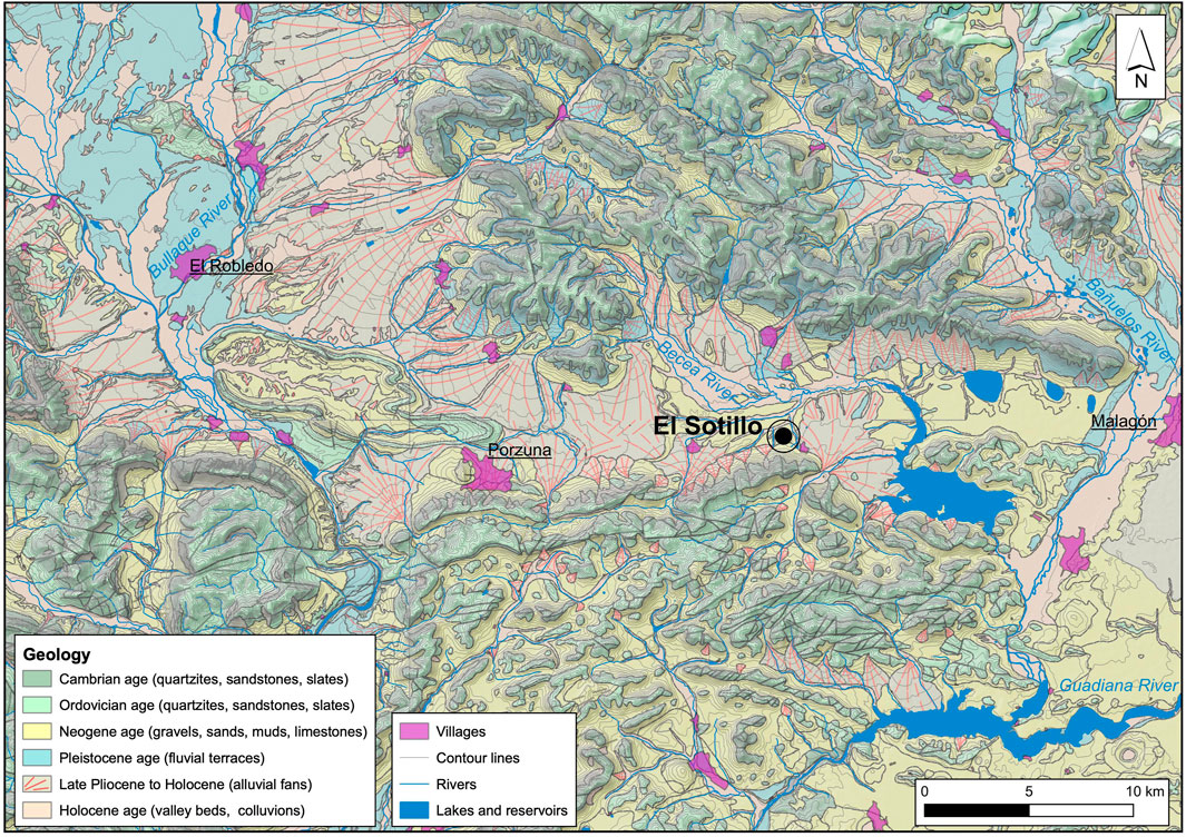
FIGURE 2. Geological framework of the El Sotillo site (645 m. a.s.l.) in the Porzuna - Malagón synclinorium, with the Malagón quartzite hill (1070 m. a.s.l.) to the north and the El Sotillo sierra (890 m. a.s.l.) to the south. The Porzuna - Malagón synclinorium is crossed from W-E by the Becea River, a tributary on the right bank of the Bañuelos River, which is, in turn, a tributary of the Guadiana River. Map made with data layers provided by IGME.
The upstream action of the rivers on the right bank of the Guadiana barely affects the territory of the previously mentioned synclinorium. Bullaque River conforms an anastomosed channels network crossing a 2–10 km wide alluvial plain (Figure 2). The raña -the name given to quartzite fan deposits, usually of large planar dimensions, from the Pliocene-Lower Pleistocene and prior to the first fluvial terrace of the current networks-is found in these sectors at +10–12 m above the alluvial plains of the Alcubilla and Bullaque rivers. Downstream from the area where the Bullaque and Guadiana meet, a more developed sequence of terraces can be observed, with levels at +2–3 m, +6–10 m, +12–14 m, +15 m, +20–22 m, +40–45 m and +60–65 m, with the raña at +80 m (Piles et al., 1986; Portero et al., 1986; Ramírez Merino et al., 2000).
In the eastern sector of the El Robledo synclinorium, on the Malagón meridian, in the Bañuelos River we have recognised a geomorphological unit similar to that of the Bullaque River. It presents an extensive alluvial plain crossed by multiple fluvial branches and two terraces at +2 m and +6 m until it flows into the Guadiana River (El Vicario reservoir, Figure 1). The Becea River and the streams of its drainage basin have hardly any impact on its substratum, a geodynamic situation derived from the almost non-existent encasement of the base level imposed by the Guadiana River at the western end of the Plains of La Mancha. Another decisive factor in the scarce incision of the fluvial network is related to the excess of available coarse load, inherited from the reliefs draining from the Montes de Toledo, and which ends up favouring the formation of extensive alluvial plains and anastomosing channel morphologies, as is the case of the Bullaque and Bañuelos rivers.
The Becea River is about 5–6 m below the Raña and 15–16 m in the lower surface of the Plain of La Mancha. It is a formation with sandy-silty-clay carbonate facies at the base and laminar crusts, slightly less than 1 m thick at the top. This morphostratigraphic unit is preserved in the vicinity of the El Sotillo site (Figure 2).
2.2 El Sotillo Stratigraphy
The El Sotillo site has a 1.5 m thick stratigraphic sequence, and it contains Acheulean and Mousterian industries and rests directly on the Tertiary (Neogene) substratum. From a geomorphological point of view, it is located on the NW limit of the El Sotillo-Raña fan, associated with ancient fluvial courses coming from the Lower Ordovician quartzite hills, which produced deposits particulate material from gravel to silt-clay. Currently, the shallow El Sotillo stream, runs over the site, eroding it locally.
The recognised stratigraphic sequence at El Sotillo, sectors A and B, which are 20 m apart (Supplementary Figure S1), displaying common sedimentary characteristics. The fluvial deposits recognised in both sectors are accumulated on an erosive surface affecting the Neogene substratum (Figure 3). Five levels have been differentiated. The oldest (level 5), which carries bed load gravels, has Acheulean industry. Levels 4, 3 and 2 correspond to fluvial sediments of Holocene age, according to the dates obtained and presented in detail in the following section. Level 1 is an overflow deposit from the present-day El Sotillo channel. There is no record of lithic industry for the upper levels from the 4.2 to 1.
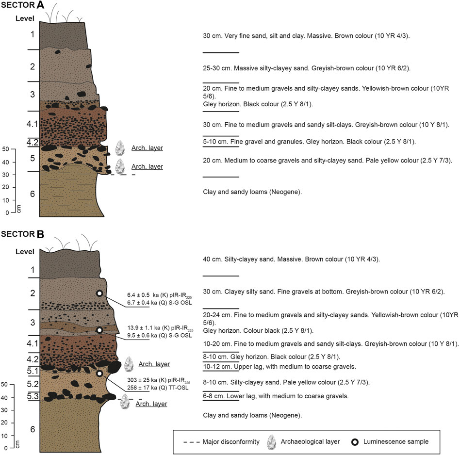
FIGURE 3. Stratigraphic columns of sectors A (above) and B (below) of El Sotillo.
The lower terminus (level 5) carries larger clastic elements (between 10–12 cm and a centile or maximum size of 17 cm). Two concentrations of coarser materials (lag deposits) are distinguished at the top and at the bottom, both with industry, separated by sandy-clay facies. The lower one can be interpreted as a fluvial bar and the upper one corresponds to a second reactivation surface due to a higher water flow. The levels 4, 3 and 2 are composed of fine to medium size gravels (between 1-2 and 6 cm, measured at the major axis of the clast), that grades upwards to silts and clays indicating a progressive loss of energy. Level 1, with the highest percentage of fine and medium sand, represents over-flow deposits of the current channel, and according to the available chronologies of the different levels of the El Sotillo deposit, they have an intermittent activity separated by thousands of years.
Levels 5 to 2 are characterised edaphically by gleying pedological processes throughout the profile. It contains hard black nodular concentrations of MnO2 up to 1 cm in diameter, particularly at the bottom of levels 3 and 4.2. The poor drainage, both laterally and vertically, is due to the low dip of the fluvial plain and the low permeability between the different levels, as they contain high percentages of silts and clays (60–70%).
The stratigraphy of Trenches C and D (Supplementary Figure S2, S3), from top to bottom, starts with a 40 cm thick anthropogenic colluvium, made up of soil disturbed and partially removed by heavy machinery, probably from the piping works (2008-2009) from the Torre de Abraham dam to the Gasset reservoir.
Next, in abrupt contact, follows level 2T, which is a layer 18–20 cm thick and contains Mousterian industry. It is composed of fine sands and silt-clays, with a massive internal structure and a brownish-dark brown colour (7.5 YR 4/4). This layer is in flat contact with the inferior level 3, which is 45 cm thick, made up of silt-clays and sand, more abundant on its base, together with irregularly distributed coarse clasts, sometimes grouped in the form of ‘nests’. This level also contains Mousterian industry and is affected by a pedological process of clay illuviation; it has a strong polyhedral structure and a yellowish-red colour (5 YR 5/6). Level 4 contains Acheulean industry. It has a variable thickness of 5–25 cm and is composed of sands and fine gravels in which scattered coarse gravels appear; it is in erosive contact with the clayey Neogene level 5. Levels 4 and 5 show very accentuated hydromorphic soil conditions, similar to those observed in sectors A and B.
2.3 El Sotillo Luminescence Dating
Luminescence dating was conducted at the University of Adelaide’s Prescott Environmental Luminescence Laboratory. Three luminescence samples were collected from Levels 5, 3 and 2 in excavation area B (Figure 3). Sample STL17-1 was collected from Level 5, within a 10 cm-thick clay-rich sediment layer sitting atop Miocene clays; sample STL17-2 was collected 30 cm above sample STL17-1, from the overlying Level 3, which is composed of fine sands and gravels; and the uppermost sample, STL17-3, was collected 35 cm above sample STL17-2 from Level 2, a floodplain deposit composed of fine sands with small gravels at the base. Post infrared (IR) IR stimulated luminescence (pIR-IR) dating of coarse K-rich feldspar grains was applied to all samples (Buylaert et al., 2009; Arnold et al., 2015). Additionally, single-grain optically stimulated luminescence (OSL) of quartz grains (Arnold et al., 2016) was applied to STL17-2 and STL17-3, as preliminary screening revealed that the burial doses of these two samples lie within a range that is generally suitable for conventional OSL dating (Arnold et al., 2015). STL17-1 exhibited a significantly higher burial dose estimate in preliminary screening tests, hence it was necessary to apply single-grain thermally-transferred OSL (TT-OSL) of quartz grains instead of replicate single-grain OSL to this lowermost sample (Arnold et al., 2015).
Sample preparation procedures, instrumentation, dose rate estimation, equivalent dose (De) measurement protocols, and luminescence characterisation results are detailed in the Supplementary Material. Samples were prepared using standard procedures under subdued red lighting to isolate the coarse (90–125 μm) K-rich feldspar and (212–250 μm and 90–125 μm) quartz fractions (see Supplementary Material for details). Dose rate evaluations were undertaken using a combination of in situ gamma-ray spectrometry and low-level beta counting (see Supplementary Material for details). Gamma spectrometry data was analysed using the “windows” method described in Arnold et al. (2012) to obtain concentrations of K, U and Th for gamma dose rate evaluations. Dose rates were calculated using the conversion factors of Guerin et al. (2011), accounting for beta attenuation (Brennan, 2003). Cosmic-ray dose rates were calculated using the approach described in Prescott and Hutton (1994). Internal dose rate contributions for K-feldspar grains have been estimated using an assumed internal 4 K content of 12.5 ± 0.5% (Huntley and Baril, 1997) and 87Rb content of 400 ± 100 ppm (Huntley and Hancock, 2001). The long-term water content was taken as being equivalent to the present-day water content values measured for each sample, which ranged between 4% and 14% of dry weight. An uncertainty of 20% was added to the water content to account for any potential minor variations during the past. Final dose rates are shown in Supplementary Table S1. Present-day secular equilibrium of the 238U and 232 Th decay series was investigated via additional high-resolution gamma spectrometry (HRGS) measurements. Daughter-parent isotopic ratios for 238U, 226Ra, 210Pb, 228Ra and 228Th are consistent with unity at either 1σ or 2σ for all three samples, indicating that the 238U and 232Th chains exhibit present-day secular equilibrium (see Supplementary Table S2).
3 Results
3.1 Luminescence Results
Elevated temperature pIR-IR signals measured at 225°C (pIR-IR225 protocol shown in Supplementary Table S3) were used to date the samples in this study following the results of dose recovery tests performed using different pIR-IR measurement conditions (see Supplementary Table S4). Twelve aliquots containing ∼160 grains of K-feldspars were measured for each sample. The natural De datasets of samples STL17-1 and STL17-3 exhibit low to moderate overdispersion values (19–23%) and are not significantly positively skewed according to the test of Arnold and Roberts (2011), consistent with sufficient bleaching of the dating signal prior to burial (Supplementary Table S7, Supplementary Figure S7A,C). Mean De values and final burial ages were calculated using the central age model (CAM; Galbraith et al., 1999). In contrast, the De distribution of sample STL17-2 shows significantly higher overdispersion (52 ± 12%), though it is not considered significantly positively skewed (Supplementary Table S7 and Supplementary Figure S7B). These De characteristics may indicate insufficient bleaching of some K-feldspar grains prior to burial (or additional complications), with multi-grain averaging effects resulting in complex (non-skewed, uniform) expressions of extrinsic scatter. Statistical comparison of the CAM, the 3-parameter minimum age model (MAM-3) and the 4-parameter minimum age model (MAM-4) (Galbraith et al., 1999) results using the Lmax test of Arnold et al. (2009) indicates that the MAM-4 provide the most suitable fit for this De distribution (see footnote d of Supplementary Table S7). Based on these results, along with insights gained from the replicate single-grain OSL measurements made on this sample (see below), we have used the MAM-4 to derive the final age for STL17-2 (Supplementary Figure S7B; Supplementary Table S7).
The single-grain OSL and TT-OSL De distributions of samples STL17-3 and STL17-1 are characterised by low to moderate scatter (overdispersion = 23 ± 3% and 27 ± 4%, respectively; Supplementary Figure S8A,C) and are not considered to be significantly positively skewed at 2σ. These homogenous De characteristics are consistent with the paired K-feldspar pIR-IR De datasets for STL17-3 and STL17-1, confirming adequate signal resetting prior to burial. The final OSL and TT-OSL ages of both samples have therefore been calculated using the CAM (Supplementary Table S8). The corresponding single-grain OSL dataset for sample STL17-2 (Supplementary Figure S8B) shows high levels of scatter (overdispersion = 60 ± 5%) and statistically significant positive skewness. This single-grain De dataset therefore confirms that Level 3 is affected by enhanced extrinsic dose dispersion, which may originate from: 1) insufficient resetting of residual signals for some grains during fluvial transportation, 2) localised post-depositional mixing of grains from the layer below; or 3) the inadvertent incorporation of material from the layer below during sampling (i.e., accidental cross-cutting of stratigraphic layers). It is difficult to ascertain which of these scenarios explains the enhanced De scatter of sample STL17-2 without further sampling. However, the MAM rather than the CAM is likely to provide a more representative burial dose estimate for Level 3 under all three scenarios. This is reinforced by the results of the Lmax test, which suggests that the MAM-3 produces a more suitable fit for this dataset compared to the CAM or MAM-4 (see Lmax scores and footnote d of Supplementary Table S8). As such, we have used the MAM-3 to derive the final single-grain OSL age for STL17-2. It is worth noting that the CAM, MAM-3 and MAM-4 age estimates for STL17-2 are statistically indistinguishable at 2σ, hence our interpretations are not strongly influenced by age model preferences in this instance.
The final luminescence ages for the three El Sotillo samples are shown in Table 1. The replicate K-feldspar and OSL/TT-OSL ages for each sample are in general agreement, supporting the overall suitability of the combined dataset (including our age model selections). The K-feldspar and single-grain OSL ages for Level 2 are 6.4 ± 0.5 ka and 6.7 ± 0.4 ka, respectively. Level 3 is dated to 13.9 ± 1.1 ka using K-feldspar pIR-IR and 9.5 ± 0.6 ka using single-grain OSL. The lowermost dated layer (Level 5) is significantly older, yielding consistent K-feldspar and single-grain TT-OSL ages of 303 ± 25 ka and 258 ± 17 ka, respectively. For samples STL17-1 and STL17-3, the replicate ages are consistent with each other at 1σ or 2σ. For sample STL17-2, both luminescence ages are stratigraphically consistent with surrounding ages, though they do not overlap with each other when considering their 2σ error ranges. For this sample, the single-grain OSL age of 9.5 ± 0.6 ka is preferred since it is based on measuring individual mineral grains and thus enables more useful insights into the extrinsic De scatter affecting this sample in the absence of multi-grain averaging effects (unlike the pIR-IR K-feldspar dataset).
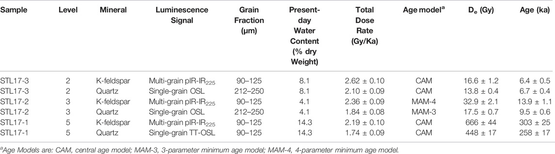
TABLE 1. Final luminescence ages obtained for the El Sotillo (excavation sector B) samples.
Our luminescence dating results indicate that Level 5 is a Middle Pleistocene layer (that include the lithic assemblage) deposited during 245–345 ka (weighted mean age at 2σ), which corresponds largely with marine isotope stage (MIS) 8 (Lisiecki and Raymo, 2005). The overlaying Levels 3 and 2 (devoid of archaeological record) were deposited ∼9.5 ka and ∼6.5 ka, respectively, during the Holocene.
3.2 Technical Study of the Acheulean Industry From Sectors A and B at El Sotillo
Our analysis of the lithic industry of El Sotillo is structured around the extended concept of chaîne opératoire, (Boëda et al., 1990; Inizan et al., 1999). In the exposition, we will follow the order derived from the identifiable phases in the process of elaboration and consumption of the tools (Table 2). We will base our study upon the technological reading of all the lithic artefacts and in the analysis of their basic physic features, such as raw material, size, and weight.
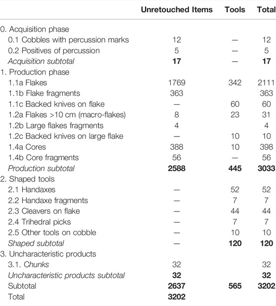
TABLE 2. El Sotillo. Level 5 lithic industry from A and B Sectors. Totals and subtotals in bold.
3.2.1 Petrological Features. Raw Materials Provenance
We will present the results corresponding to the study of the lithic industry recorded in sectors A and B (Supplementary Figure S1, S3). The series studied was obtained in the 2017 and 2018 campaigns and comes entirely from stratigraphic level 5 (Figure 3), particularly levels 5.1 and 5.3, gravel lags where the industry is concentrated, separated by a sterile sandy-clay deposit (level 5.2). In total, an area of 14.9 m2 was excavated: 12.2 m2 in sector B and 2.7 m2 in sector A. The series comprises a total of 3202 pieces (Table 2), 693 from sector A and 2509 from sector B, producing an average density of c. 641 pieces per m3 of sediment in sector A and 514 per m3 in sector B. This data corresponds to the highest concentrations of industry recorded in Acheulean sites on the Iberian Peninsula in a similar sedimentary environment -fluvial gravel bars- (Supplementary Table S9).
Trench C-D (40 m2) was opened in the 2017 campaign. From the trench, areas D and F were excavated in 2018 and 2019 (Supplementary Figure S1). Two levels with lithic industry were obtained (Supplementary Figure S2), and their ongoing study has allowed us to attribute them to the Acheulean and Mousterian, respectively. These levels are stratigraphically above the Acheulean level of the A and B sectors.
About 99% of the lithic assemblage found at El Sotillo level 5 (sectors A and B) is composed of different types of quartzite. Locally, quartzite is the most abundant raw material; it is available and easily accessible in the “Raña” or in the Quaternary terraces and colluvium. It is composed of orthoquartzite, quartzite, quartz arenites pebbles and blocks with a sandy matrix. The primary source of these rocks is the lower Ordovician formation outcropping in the adjacent hills, such as Sierra de Malagón and Sierra de Fuenluenga in the north and Sierra del Sotillo south of the site.
Moreover, there is also one specimen in quartz and one in aphanitic volcanic rock. Although quartz is not abundant in the region, it can be found in veins with decimetric to metric thickness of the Lower Ordovician series, associated with fractures in the NNE-SSO direction. The larger veins are represented in the geological maps in the western region of the Montes de Toledo, about 10 km in an SSE direction and in a straight line from El Sotillo. Also, some small quartz pebbles of between 2 and 6 cm can be found in the terraces in the vicinity of El Sotillo.
Volcanic formations of the Upper Miocene and Lower Pleistocene are known in the region, corresponding to the NW sector of the Spanish Central Volcanic Region or Campo de Calatrava. An outcrop of hydromagmatic deposits within the sedimentary Pliocene deposits and associated eruptive pipes can be found, controlled by fault systems, in the Ordovician formations of the bedrock. The closest volcanic formations to El Sotillo are eruptive cones associated with a fault located 6 km away in a straight line in the SW direction and a hydromagmatic deposit 10 km away in the W direction, in the vicinity of Porzuna.
Less than 1% of the lithic material in the excavated trenches is exogenous although regional geological mapping indicates that its provenance is likely not far away. Of this material, seven pieces are chert. Among the chert pieces, there is one scraper, and the rest are flakes or knapping products. It is particularly noteworthy that four of these chert pieces are small-sized knapping residues likely from the same support, most probably a large tool, which may have been brought to the site already configured and then re-shaped.
Current data indicates that the raw material exploited is almost entirely local, available at least within a 10 km radius of El Sotillo. However, it should be noted that there is no sign of chert within this radius. The few specimens in chert, especially the four pieces mentioned probably came from the same support and indicate greater mobility in the landscape and differentiated curation and management strategies of resources.
3.2.2 Raw Material Acquisition and Production Phases
The raw material acquisition phase (Table 2) is only represented by 12 cobbles with traces of use as a hammerstone and five fragments produced by the use of these artefacts. All of the recognised hammerstones are quartzite pebbles, ranging from 112 to 53 mm in length and weighing 763–66 g. Half of them weigh between 344 and 399 g, two are smaller (66 and 80 g) and only one is significantly larger (763 g). These elements are perfectly proportionate for the knapping of cores and configured tools recorded on site. The reduced representation of percussion elements, especially of small pieces suitable for retouching, is explained by textural features of fluvial deposits where the availability of cobbles suitable for use as percussion tools is very high. For this reason, there is no need for repeated use of the same element, leading to pieces with low-intensity use-wear traces that are difficult to identify.
Cores and flakes are the main component of series (94.7%). Part of this assemblage (14.7%) corresponds to retouched tools, including backed knives. All phases of core and artefact reduction are represented, from fully cortical products to flakes with no cortex remains, double bulbar-faced flakes (Janus and Kombewa), and knapping and retouching flakes. There are also elements characteristic of the reduction of the flaked surfaces in the cores, such as plunging flakes, core-tablet and semi core-tablet, and flakes produced on the more organised extraction surfaces (Supplementary Table S10). Some flakes with Levallois morphology were identified. However, given the absence of cores from this method, we interpret that they may have come from the centripetal surfaces exploited in discoidal cores, or even from the handaxe shaping.
The overall dimensions of the flakes (Figure 4A) show a weak presence of elements with lengths of less than 35 mm. The most frequent values observed in the core scars are practically unrecorded in the series studied. This situation must be related to the negative influence of the sedimentary environment on the preservation of smaller pieces. Smaller values observed in the cores (Supplementary Table S11) are absent or under-represented in the flakes of the series.
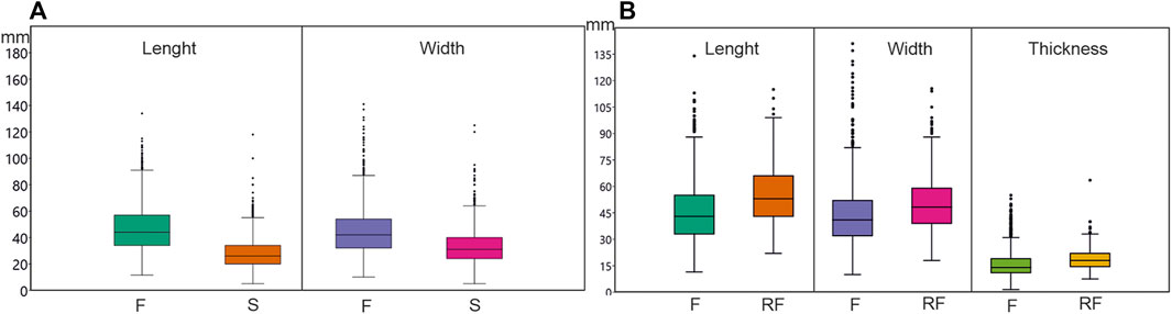
FIGURE 4. (A). Boxplot of the typometric values of flakes and macro flakes retouched and unretouched–F- (Length, N=1732; Width, N= 1834) and scars identified in cores–S- (N = 1625). (B). Boxplot of the typometric values of unretouched flakes–F- (Length, N=1385; Width, N= 1519; Thickness, N= 1776) and retouched flakes–RF- (Length, N=266; Width, N= 315; Thickness, N= 425).
By comparing the measurements of flakes and cores (Supplementary Table S11), as well as those of the large flakes with larger dimensions greater than 10 cm, belonging to the largest cores (Supplementary Table S12) we can observe that practically all the flakes of the series could have been produced in the cores contained in it. There are only a few large flakes with measurements larger than those of the cores studied (Supplementary Table S12). On the other hand, in the cores we can observe scars of smaller sizes than those of the flakes in the series studied (Supplementary Table S11).
Taking into account this range of flake size recorded -including support flakes from part of the cores-the balance between flakes and cores shows a proportionality of 6.1/1. Considering the 120 tools configured (Table 2) and, out of these, the ones made on flakes (71 pieces in total, 26 handaxes, 44 cleavers and one trihedral pic), this index drops to 4.9/1. These values are an approximation of real proportions between products and flaked supports. The indexes obtained show that not every flake produced is preserved in the excavated fluvial deposit and that the smaller ones, in particular, are missing. The direct relationship between cores and flakes is proven, and the set of flakes preserved can be accepted as representative of production in the initial and middle phases of the exploitation of the cores and of the production of the configured tools that make up the series.
A total of 398 complete cores were identified, 10 of which are retouched and 56 fragmented, most of them probably during their exploitation. Flakes are the most frequent support (54.1%), slightly more than cobbles, despite the availability of cobbles of various sizes and shapes. Among these, angular cobbles (32.1%) were chosen more frequently than globular cobbles (8.8%), and, to a lesser extent, cobbles of rectangular cross-section (5.0%) (Supplementary Table S13).
The technical interpretation of the cores is based on the identification of the exploitation system through the reading of the flaking sequences and the identification of hierarchical or equivalent -interchangeable- exploitation surfaces. The type of support, the intensity of exploitation and the size of the removal negatives have also been taken into account in order to establish comparisons with that of the flakes.
Poorly organised exploitation systems (occasional, monopolar and bipolar) account for 26.1% of the knapping methods identified. Bifacial (22.5%) and discoidal (20.7%) exploitation are also frequent, and to a lesser extent peripheral monopolar (14.0%) and multipolar exploitation (8.8%) (Figure 5. 4). In 18 cores, the application of more than one method has been recognised (Supplementary Table S13).
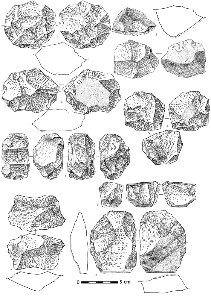
FIGURE 5. Cores. Discoidals: bifacial (1), unifacial (2) and discoidal with differentiated striking platform (3); multipolar (4); peripheral monopolars (5, 6); bifacial on flake (7), and bifacial on flake retouched (8). All on quartzite.
In bifacial cores, a portion of the outline was reduced bifacially from the equatorial edge (Figure 5. 7–8). Among the cores with a centripetal extraction method (Mourre 2003a), those with two extraction surfaces–bifacial discoidal–are more common than those with only one. Few hierarchical specimens with defined peripheral percussion platforms have been recognised (Figure 5. 1–3). The peripheral monopolar group (Figure 5. 5–6) includes specimens with perpendicular and peripheral extractions to flat percussion surfaces cortical in some cases and formed by wide extractions in others. This exploitation system can be related to the Quina method (Bourguignon 1997), which we have recorded in African Acheulian sites from the Lower Pleistocene (Santonja et al., 2014).
Specimens developed on flakes can be recognised in all the exploitation systems (Figure 5. 7–8). These cores have produced flakes with double ventral faces, which have been recognised in 42 flakes in the assemblage (Supplementary Table S10). There are also 15 kombewa cores (Supplementary Table S13) in the strict sense (Tixier and Turq, 1999), which have produced single flakes, or several independent ones, taking advantage of the convexity of the ventral surface of the supporting flake.
Although rare, 10 cores retouched, after being exploited, have also been identified, forming tools comparable to those made on flakes, half of which are scrapers (Figure 5. 8), as well as notches, denticulates and awl. In addition, the presence of 32 core residues or chunks, which, when combined with the frequency of cores and flakes, confirms that the production process took place at the site.
3.2.3 Consumption Phase: Retouched Flakes
The identification of retouched artefacts in the El Sotillo assemblage allows us to recognise the consumption phase. These artefacts have been analysed following a technological methodology (Inizan et al., 1999: 67 and ff.). The typological terminology applied follows that established by F. Bordes (1961). They have been analysed following an analytical methodology that takes into account the location, direction and shape of the retouched side (Inizan et al., 1999: 67). We have accepted to keep the backed knives in the group, although, in the absence of traceological confirmation, they are theoretical tools, sometimes selected for use only because of their morphology.
A significant number of flakes (342 pieces, not including large flakes) displays modifications from retouching (Supplementary Table S5). Alongside this group, 60 configured flakes that follow the concept of backed knife (Bordes 1961) with a typical, cortical or debitage back must be considered. In total, 402 pieces represent 15.9% of the flakes under 10 cm (groups 1.1a, 1b and 1c, Table 2). There are 145 scrapers of very different sub-types, and they are the most common group (36.1%). Notches (25.4%) and backed knives (11.9%), with retouched backs and with cortical or debitage backs, are also common. The average sizes of these pieces are larger than those of unretouched flakes, but it is interesting to note the presence of tools with lengths of less than 25 mm (Supplementary Table S11).
Often, scrapers have single retouched edges, straight or convex -in a few cases concave- and in a lateral or transversal position. The retouching can be direct or inverse, well-defined and carried out with a hard hammer. Generally, the retouching is simple, although examples exist with semi-abrupt retouching or stepped retouching (Figure 6. 16). Amongst these scrapers, there are a significant number of pieces with backs, in which the cutting edge opposes a frequently cortical back, in some cases with debitage or retouching (Figure 6: 12, 15, 18). There are also double scrapers, sometimes with alternating retouching, and in many cases, convergent with regular and well-defined shapes (Figure 6. 17–19).
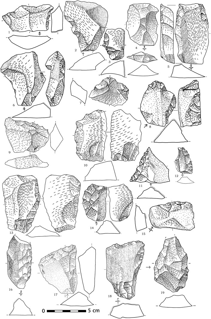
FIGURE 6. Flake tools: double notches (1, 2); bec (3); flake with Levallois morphology (4); typical and cortical back knives (5, 6); end-scrapers (7, 8); denticulates (9, 10, 11); convex scrapers (12, 13, 14), straight scraper (15), straight scraper with stepped retouch (16) and convergent scrapers (17, 18 and 19). Chert (18) and quartzite (1-17 and 19).
Most of the notches are multiple, extensive and unretouched, with two or three independent notches present on each piece (Figure 6. 1–2). There are fewer numbers of denticulates (Figure 6. 9–11) than scrapers, and although few in number, there is also a presence of more specialised tools, such as end-scrapers (Figure 6. 7, 8) and awls or becs (Figure 6. 3).
In addition to the above group, we must add the group formed by the retouched large flakes. In this group, the proportion between unretouched and more configured retouched products, 12 and 33 pieces respectively (Table 2), is the inverse of that observed in the previous assemblage. 73.3% of these products are retouched, suggesting that the large flakes may have been specially chosen to be transformed into tools. When comparing the size of these pieces with those of the cores (Supplementary Table S12) we cannot rule out the possibility of on-site production and we cannot provide arguments to support possible introductions from outside. However, the features of the dorsal face of these flakes indicate that a significant part, in particular 11 pieces (Supplementary Table S15), come from discoidal exploited platforms, and only in two discoidal cores does the largest dimension exceed 100 mm (102 and 114 mm, respectively). Eight of the 11 flakes mentioned measure more than 115 mm, reaching up to 188 mm, so it is not possible for them to come from the discoidal cores recognised at the site and they may have been introduced from the outside, already retouched.
The presence of 23 macro tools on flakes larger than 10 cm is another noteworthy part of the El Sotillo assemblage. In addition to 18 scrapers (Goren et al., 2008), three notches and two denticulates are also part of this group. The most frequent scrapers are convergent, with seven pieces (Figure 7. 5 and 6) and there are also five transversals (Figure 7. 1, 2 and 4), three double, two single lateral convex and one inverse (Figure 7. 3). Some present extensive retouching, but most have simple continuous retouching, similar to that observed in smaller specimens. This group also includes 10 backed knives, specimens with retouched backs (3), debitage backs 4) and cortical backs (3). The measurements and weights of the retouched large flakes are distributed between 114 and 188 mm for the largest dimension of complete pieces (17), and between 240 and 1180 g for the same group, with respective averages at 139.0 mm and 533.6 g. In the case of the slightly larger backed knives, the mean values are 141.9 mm and 571.1 g, with values ranging from 106 to 207 mm for the length and 344–1460 g for the weight.
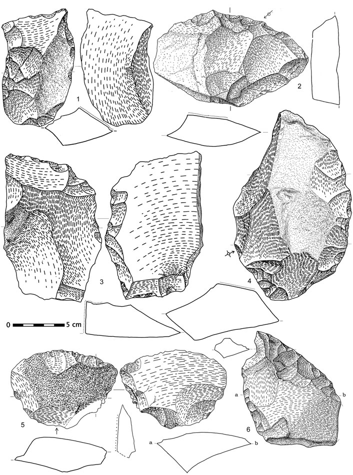
FIGURE 7. Scrapers on large flakes: Single transversal (1, 2 and 4), inverse (3) and convergents (5 and 6, this one associated whit a notche). All on quartzite.
3.2.4 Consumption Phase: Shaped Tools
Here, we analyse artefacts shaped on natural blank or a large flake by a specific knapping sequence, with the aim of producing a specific object (Inizan et al., 1999: 41 ff.). This set comprise handaxes, cleavers on flake and trihedral picks. In addition, we add other tools to this group, which are also made on natural blank. In total, they represent 120 pieces (Table 2), confirming the attribution to the Acheulean techno-complex of the studied assemblage.
In the identification of the handaxes, we start from the technological concept of bifacial shaping, according to which it is possible to divide the bifacial shaped into two phases: drafting and finishing. The first is mainly related to the bifacial volumetric proportion and the second to the bilateral symmetry (Inizan et al., 1999: 41 f.). At El Sotillo, it constitutes the largest group with 59 pieces, comprising seven fragments, one preform and 51 complete tools (Figures 9, 10). Four of the fragments probably correspond to the tips of lanceolate handaxes. They correspond to finished specimens and may have been produced accidentally during use. In two of them, we can observe the intervention of an organic hammer in the finish and, in another, retouching that defines a scrapper on one side (Figure 10.9). In addition, three basal fragments and one preform, a piece abandoned during the shaping process. The presence of this type of residue confirms that at least some of the bifaces were shaped on-site.
Sizes of handaxe not affected by fractures vary between 61 and 181 mm. Two groups can be distinguished, with both pointed and unpointed specimens in both groups. There are 23 complete pieces with sizes between 60 and 115 mm and another 14 specimens larger than 140 mm, with two intermediate values (Figure 8A). The weights show a further contrast between the two groups. In the smaller group, weight varies between 50 and 222 g, with 11 pieces below 100 g. In the larger group, the weight ranges from 437 to 980 g, with only two pieces weighing less than 500 g. The average length of the whole complete handaxes is 114.8 mm, which is not very representative of the distribution observed. Ten pieces show distal fractures probably caused by use, and in only 3 cases is retouching observed on the fracture itself (Figure 9. 1).
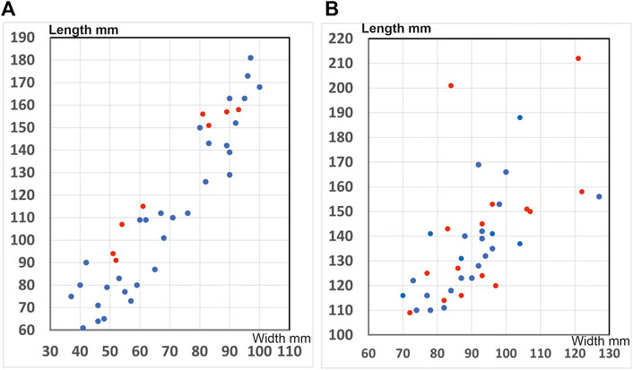
FIGURE 8. Scatterplot of length and width measurements of the unfractured handaxes (A) and cleavers (B). (A) Red dot, pointed handaxes. Blue dot, non-pointed handaxes. (B) Red dot, types 0 and I of cleavers. Blue dot: type II of cleavers and variants.
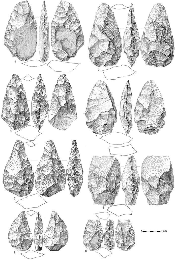
FIGURE 9. Handaxes. Lanceolate (one to three and 8), amygdaloid (4 and 5), transverse cutting edge (6), and subtriangular (7). Quartzite (1-6 and 8) and chert (7).
Most of the handaxes (80.4%) have pointed silhouettes, with a high proportion of lanceolate, amygdaloid and cordiform shapes (cf. Bordes 1961). The presence of a small subtriangular handaxe is exceptional. Non-pointed handaxes make up the remaining 19.6%, with ovate shapes being the most regular, in conjunction with a transverse cutting edge specimen and two other core-like handaxes with a less well-defined outline (Supplementary Table S16).
There are 20 examples of handaxes with amygdaloid silhouettes (Figure 9. 4–5 and 10.3–5) and six with similar but flatter silhouettes (Figure 10. 6–8), with width/thickness ratio higher than 2.35, which can be differentiated as cordiform (Bordes 1961). In 13 cases they have been made on flakes, with only two on flattened cobbles and another two on angular cobbles. The knapping is generally bifacial and invasive, affecting the basal area, with the intervention of an organic hammer in the final regularisation in 14 pieces. In general, silhouettes are symmetrical, with both sides convex, although among the amygdaloids there are four specimens with one straight side, one with a concave side and another with a straight cortical back on one of the sides (Figure 10. 5). A small transverse cutting edge is observed on three amygdaloid (Figure 9. 5) and on three cordiform handaxes. One of the amygdaloid has two opposing notches in the basal area (Figure 9. 4). Two others in this group display retouched lateral sectors, in one case using stepped retouching, forming a scrapper, and in another, a denticulate edge. In one cordiform handaxe, the final retouching creates another denticulate edge. Overall, three handaxes support-tools have been recognised (cf. Boëda et al., 1990).
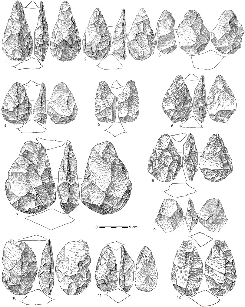
FIGURE 10. Handaxes. Small and medium-sized lanceolate (1-2), short amygdaloid (3-4) and short amygdaloid with back (5), cordiforms (6-8), oval (10) and elongated oval (11-12). Retouched biface tip (9). All on quartzite.
The classic lanceolate handaxes are characterised by straight edges converging towards a pointed end, which is opposed to a globular base (Bordes, 1961). Those recorded at El Sotillo constitute a representative group (Figure 9. 1–3, eight and Figure 10. 1–2). However, some of them deviate from the general characteristics indicated, either due to their narrow straight terminal cutting edges–three specimens– (Figure 9. 1) or slightly dissymmetrical silhouettes with a somewhat convex side in two cases (Figure 9. 8). The major exception is the presence of nine lanceolate handaxes with no globular base -i.e., sharp base- (Figure 9. 2 and 3). As in the case of the amygdaloids and cordiform handaxes, flakes are the most common identifiable support in six specimens. Flattened cobbles as a support are recognised in two handaxes and an angular cobble in another. The bifacial shaping is generally extensive, and in five pieces any residue of its supports has been eliminated. The intervention of an organic hammer is recognisable in eleven pieces. Opposing notches close to the basal area are also observed in two lanceolates (Figure 9. 8), confirming that this is an intentional technical gesture, which may have the purpose of facilitating some form of hafting.
A handaxe with a flat subtriangular outline (Bordes, 1961), with asymmetrical sides, concave and convex, and a thick cortical base (Figure 9. 7) completes the group of pointed handaxes. This piece is not made of quartzite, but of chert, a rock that is not known in the immediate surroundings of El Sotillo, and may have already been worked when it was introduced into the site.
Handaxes with a non-pointed silhouette are not frequent and are reduced to seven ovals (Figure 10. 10–12) -three of them narrow ovals, limandes, in the terminology of Bordes, 1961-, one piece has a transversal cutting edge (Figure 9. 6) and two are core-like. In one of the ovals there is a small distal tip and in another a narrow bevel, also at one end. The base is sharp in three of the ovals and thicker in all of the others. As far as retouched edges are concerned, only one of the core-like edges displays two contiguous retouched notches. There are hardly any support-tool handaxes in this group. In three of the ovals, an organic hammer was involved in the finishing (Figure 10. 10, 11), while in the rest only lithic hammer knapping is recognisable. Flake is the most frequent support identified, in four ovals and the two core-like. In the others, only the use of a flat cobble is recognisable in the transverse edge handaxe (Figure 9. 6).
The presence of typical cleavers on flake (we strictly follow the concept defined in Tixier, 1956) at El Sotillo, only slightly fewer in number than the bifaces, is a key element for placing your industry in the context of the Iberian Acheulian with African roots, which also extends to southern France, the Garonne and Tarn valleys (Tavoso 1978; Mourre, 2003b; Santonja and Villa, 2006; Turq et al., 2010; Santonja et al., 2014; Rubio-Jara et al., 2016; Méndez et al., 2020; Santonja, 2020).
There is a certain balance between those shaped on cortical flake -15 of type 0 and one of type I- (Figure 11)- and on non-cortical flake -28 of type II, variants included (Figure 12)-. No specimens of Tixier type VI (on flakes with a double bulbar face) have been observed, contrasting with the frequency of flakes of this technology detected in smaller sizes. This aspect highlights that the production of Janus or Kombewa flakes at El Sotillo focused on products smaller than 10 cm, not suitable to shaping cleavers.
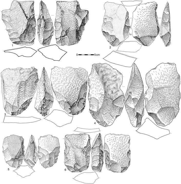
FIGURE 11. Cleavers on flake of type 0 (1, 2), of type 0 with extensive and deep knapping (3-5) and cleaver of type I (6). All on quartzite.
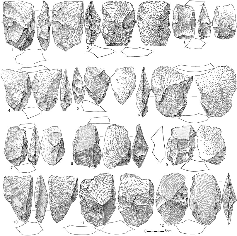
FIGURE 12. Type II cleaver on flake (1-7), and variants with a cortical edge (8-9) and partially shaped on the core (10-12). All on quartzite.
Type 0 pieces include five specimens with a deep bifacial knapping configuration (Figure 11. 3–5) relating them to Tixier’s type V; however, it is possible to recognise that the supports are cortical flakes, although sometimes very much on their limit (Figure 11. 3). In any case, it is important to take into account this intense shaping in order to avoid automatically interpreting type 0 cleavers as poorly elaborated tools.
Eleven type 0 cleavers show practically a full configuration on both faces and even in the basal area (Figure 11. 1–2), which is sharp in nine examples. Eight of them were made from side-struck flakes (Figure 11. 1, 4), with technical measurements of length less than the width, while the rest were made from flakes obtained from the base of the tool (Figure 11. 2–3, 5–6). In general, the shaping is intense, with knapping affecting both sides and even the base, giving rise to rectangular silhouettes in 11 specimens. Seven of them present a thick knapped base, four are V-shaped with only one case of convex sides and a somewhat ovate silhouette. This group is dominated by convex cutting edges and only four pieces with straight edges were recognised. There are no specimens with concave cutting edges, which is very difficult to obtain without retouching on a cortical flake. Their sizes are also homogeneous, with a group of six pieces with lengths between 141 and 166 mm (mean 153) and another group of six specimens between 110 and 128 mm (mean 118.8). Between them, there are three cleavers measuring 135 ± 1 mm, and above them, another one with a length of 201 mm.
Type II includes 28 pieces, on non-cortical flakes obtained from discoidal (7), bipolar 2) and monopolar 1) cores. The rest comes from unidentifiable cores. In a significant part, nine specimens, the cutting edge is defined by the intersection of the flake’s ventral plane with a negative in an oblique or vertical direction. At El Sotillo there is only one specimen attributable to type I (Figure 11. 6). It is interesting to note that the main technical gesture that defines this type I -the presence of a negative forming the cutting edge before the extraction of the supporting cortical flake - is a resource that is also applied at this site to the configuration of cleavers of type II on non-cortical flakes (Figure 12. 1, 3–7, 10–12). Another variant we include in type II comprises pieces in which the cutting edge is defined by the intersection of a cortical strip with the ventral surface of the flake (Figure 12. 8–9). These are pieces on flakes that are not entirely cortical and repeat the intentional selection of flakes with peripheral cortical strips as a support for the cleaver. Sometimes, these types of cleavers have been integrated into a new type VII (Benito del Rey, 1972-73; Mourre, 2003b).
The cleavers we include in type II show complete configurations of both sides and the base in 20 pieces (Figure 12. 3–5, 7). In six of them, the knapping affects one lateral side, while on the other side the area affected is limited (Figure 12. 1, 6), the configuration is completed by backs of various kinds, either cortical, an extensive negative or a deep distal bending of the supporting flake, a technical detail that is repeated in three cases, creating perfectly defined orthogonal laterals to the flaking plane (Figure 12. 12).
On two pieces, the shaping was already defined on the support flake itself on both sides; on the first, by means of the butt on one side, and on the second, by a large negative overhang almost orthogonal to the ventral plane of the flake support (Figure 12. 11). On the other piece, the supporting flake comes from a flattened cobble and the two sides of the cleaver are defined by cortical planes (Figure 12. 10). In the first of these specimens, there are two alternate opposing notches close to the base (Figure 12. 11) in a position similar to those observed in two bifaces (Figure 9. 4 and 8), as noted above.
The majority of the silhouettes of the type II cleavers 22) display a rectangular shape (Figure 12. 1–3, 7). Two of them have a slightly re-entrant side. There are five specimens with a V-shaped silhouette (Figure 12. 4–6, 10) and one that is oval, with two convex laterals. The cutting edges are varied, except for a fractured edge, we observed a similar number of straight (11, six of which are oblique) and convex 12) edges. In two cases the cutting edge is concave and in one case it is angled straight-straight. In almost all of them, there are macro-traces of use. The bases are thick in 14 specimens, sharp in 11 and V-shaped in three.
Six pieces have been identified as having an elongated shape and a pointed end with a triangular cross-section and an opposing massive base, knapping or cortical, which fits the concept of trihedral shaping (Inizan et al., 1995: 51) (Figure 13. 1–3). Most of them were made on an angled cobble with knapping on the three planes forming the pointed end. Another piece, on a flattened cobble is less characteristic from a volumetric point of view (Figure 13. 4), although it has a triangular section tip with knapping on the lateral planes, opposite a thick cortical base. This type of trihedral pick has been recognised in other Acheulean sites on the Iberian Peninsula (Querol and Santonja 1979: 124-141). The trihedral picks in the El Sotillo assemblage have an average length of 162 mm, with a maximum of 217 mm and a minimum of 114 mm. These values are similar to those recorded for handaxes; however, the average weight of the trihedral picks (764 g) is higher than that of the handaxes in accordance with the massive nature of these tools.
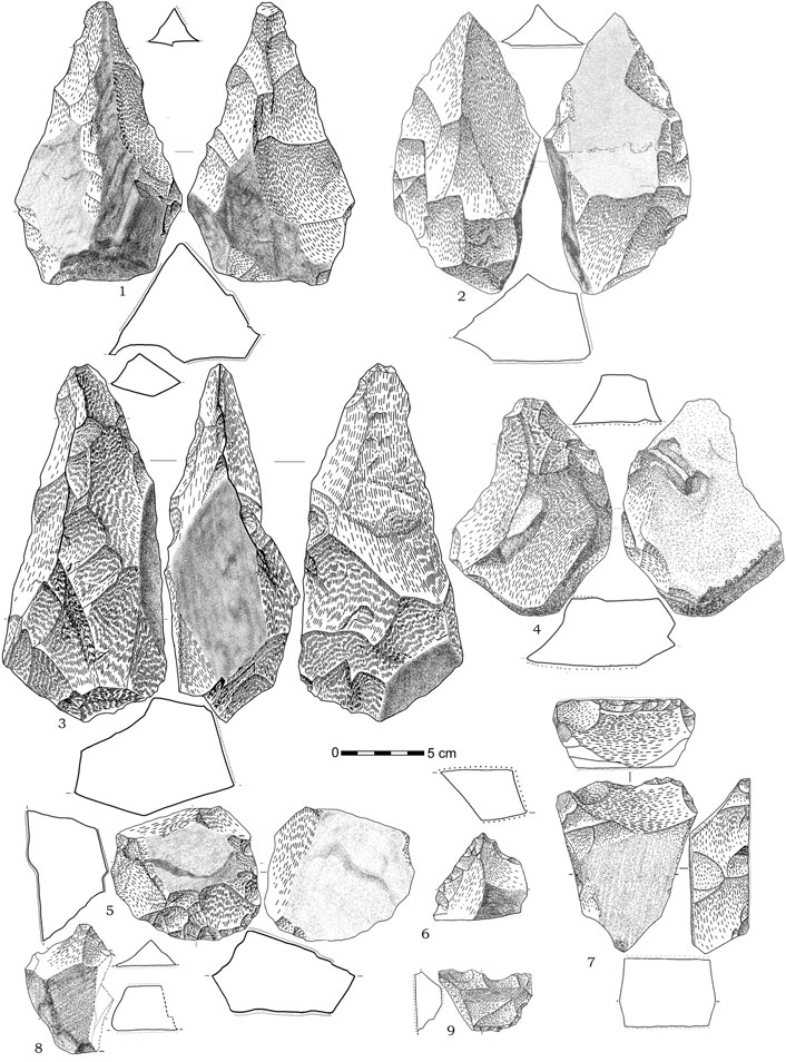
FIGURE 13. Trihedral picks (1-4) and other pebble tools (5-9). All on quartzite.
Finally, it is worth noting the presence of 10 flattened cobbles with a rectangular section, retouched to form tools similar to those found on flakes and macro flakes. Among the former, we recorded three single scrapers (Figure 13. 5), two of them opposite a retouched back and one convergent (Figure 16.6), a denticulate (Figure 13. 9) and a bec formed by the intersection of two notches (Figure 13. 8). The lengths of these pieces range between 40 and 90 mm, with an average of 65.7 mm. These measurements and types are similar to those observed in retouched flakes. This group is completed by another four slightly larger pieces, in the large flake range with lengths between 106 and 133 mm, with an average of 118.0 mm, comprising three macro-scrapers and a piece with a triangular silhouette, rectangular cross-section and wedge-shaped longitudinal section, with a V-shaped base and straight cutting edge, forming what was very probably an intentional pattern (Figure 13. 7), as it has also been recorded on two flakes.
3.3 Other Palaeolithic Sites at Porzuna
The municipality of Porzuna, covering an area of 212 km2, is partially framed by hills with scree slopes and foothills that extend towards the E-W axis of the Malagón-Porzuna synclinorium (Figures 1, 2). The Becea and Bullaque basins are a potential area for the preservation of Pleistocene deposits, as are the small streams that rise on the slopes of the sierras to the north and south of the municipal district, especially the areas with springs similar to El Sotillo. To the SW are the stepped and apparently well-preserved terraces of the Bullaque River, the highest of which link up with piedmont-type formations of alluvial origin.
The N sector of Porzuna is characterised by the wide alluvial plains of the Bullaque and the foothills of El Trincheto and El Torno rivers. These are flat alluvial plains, close to the quartzite hills from which the alluvium integrated into the Rañas originates.
Surveys carried out have made it possible to record Palaeolithic sites in all these sectors and to carry out stratigraphic verification surveys in several of them. The localities in the south-western area, in the Las Casas del Río sector, are located in the valley of the Bullaque River, mainly associated both with this river’s low terrace, at +5 m, and with alluvial fans developed on the northern slope of the immediate Sierra de Utrera. Some courses of the Bullaque River, an anastomosed fluvial course since the Pleistocene times, erode the distal positions of this fan and it is mainly in these positions where deposits have been recorded. The surveys carried out have revealed a total absence of lithic industry in the stratigraphy, while on the surface, the Acheulean industry collected in the past by amateurs was very abundant and representative.
On the lower terrace of the Bullaque River we find the classic sites of Las Casas del Río, Las Tiñosillas and Solana de los Monteros (Supplementary Figure S9), which were published under the general name of “Porzuna” (Vallespí et al., 1979 and 1985) and have become a reference for the peninsular Acheulean (Santonja and Pérez-González, 2002; Santonja and Villa, 2006). The areas with surficial lithic industry extend for almost 4 km along the valley floor of the Bullaque River, upstream and downstream of Las Casas del Río. The lithic industry obtained in these localities -tens of thousands of pieces partly stored in the Museum of Ciudad Real-, interpreted as representative of the Acheulean techno-complex (Arroyo and de la Torre, 2013; Arroyo et al., 2019), come strictly from surface levels after the terrace formation. Test pits opened in the terrace revealed a deposit of hydromorphic soils affecting silty-sandy muds with carbonates and hardened manganese concretions, which is 140 cm thick and completely sterile. The lithic industry that was recorded in the past comes from a coarse clastic alluvial facies fossilising the fluvial terrace.
In the south-eastern and northern sectors of the Porzuna district, we have also recorded numerous sites on alluvial fans and to a lesser extent in valley bottoms, in some cases also on river terraces, with paleolithic industry also on the surface. This situation has become a constant feature in the region for the numerous Acheulean and Middle Palaeolithic assemblages recorded.
4 Discussion and Conclusions
The known Acheulean sites on the Iberian Peninsula are almost exclusively located in Atlantic drainage basins, in fluvial formations of the Miño, Duero, Tagus, Guadiana and Guadalquivir basins (Raposo et al., 1985; Raposo et al., 1985; Cunha Ribeiro, 1999; Méndez-Quintas, 2007; Santonja and Villa 2006; Santonja and Pérez-González, 2010; Rubio-Jara et al., 2016; Panera et al., 2019; Méndez-Quintas et al., 2020). On the Cantabrian region, sites have also been reported (Arrizabalaga and Ríos, 2012), while in the Mediterranean drainage basin, only in the upper basin of the Ebro River some sites have been mentioned on terraces of this river close to Pamplona (Beguiristain, 1995). The influence of the Mediterranean climate and fluvial regime in the rest of the Mediterranean area has not favoured the preservation of sites in fluvial deposits (Santonja and Pérez-González, 2002).
Almost all known Acheulean sites on the Iberian Peninsula are located on river terraces. Most of these localities only provide lithic industry, although there are also some where the associated fauna shows outstanding features, such as Torralba and Ambrona (Sánchez-Romero et al., 2016), Valdocarros (Yravedra and Domínguez Rodrigo, 2009; Rubio et al., 2016) or Áridos (Yravedra et al., 2010). Therefore, they are related to ancient valley bottom landscapes when they are in stratigraphic position. A pattern of repeated placement has been observed in some of the most prominent cases, such as Porto Maior and Arbo (Miño River, Pontevedra), Pinedo, Cañete Bajo and Puente Pino (Tagus River, Toledo), La Maya (Tormes River, Salamanca) and El Sartalejo (Alagón River, Cáceres) (Santonja and Villa, 2006; Méndez-Quintas et al., 2018; Méndez-Quintas et al., 2019) in areas that constitute ecotones of high trophic capacity, and now we have to add El Sotillo to the list. The availability of diversified resources in small territories, characteristic of this type of environment, may have favoured recurrent occupations by hunter-gatherer groups in the Pleistocene.
Technologically, the Acheulean assemblages recognised in the river terraces of these regions are characterised by the use of a non-standardised flake production system and retouched tools with low degree of shapes systematisation. Shaping processes dominate in the operational chains of these industries, and debitage is often oriented - as in the African Acheulean - towards obtaining large-sized flakes that are used as a support for the manufacture of handaxes and cleavers. These essential characteristics of the Iberian series are only evident in SW France, but have not been recorded in any other European region. Usually, the raw materials are of local access and the quartzite is the more common raw material. The peninsular geological conditions do not allow the extensive conservation of faunal remains in all open-air sites, although there are examples of sites with large presence of faunal remains (Santonja and Villa, 2006). The features of the peninsular and Aquitanian Acheulean, mainly the extensive use of large flakes and cleavers on flake, relate these assemblages to the African technocomplex and clearly differentiate it from that identified in other more northern regions of Europe.
Possible Acheulean assemblages have also been noted in caves with different technological features from those recognized in open-air sites. At Atapuerca (Burgos) the complete sequence of Galería (Ollé et al., 2016; García-Medrano et al., 2017) and the upper levels of Gran Dolina (Ollé et al., 2016), as well as minor references at Sima del Elefante (de Lombera-Hermida et al., 2015). Another outstanding site is Gruta da Aroeira in Portugal (Daura et al., 2017 and 2018). At Galería, the number of tools per each level is very low, especially of clearly Acheulean implements, and they may come from outside the cave. This circumstance makes it impossible to prove the occupations established inside the cave (Santonja and Pérez-González 2021). The upper levels of Gran Dolina (TD10.1 to TD10.4, from top to bottom) displays large concentrations of faunal remains and lithic tools, that correspond to successive occupations in the cave. These assemblages are interpreted as “Mode 3″ and in the case of TD10.1 as a transition between “Mode 2″ and “Mode 3″ or “Late Acheulean” (Ollé et al., 2016), despite being a level stratigraphically above those attributed to “Mode 3". The Gruta da Aroeira assemblage (comparable to TD10.1) is characterized by extensive production of flake tools, with the presence of some handaxes, but without cleavers and other large flake tools, as is also the case in TD10. From our point of view, the lithic assemblages recognized in Aroeira -where a human skull with primitive Neanderthal characteristics was also recorded (Daura et al., 2017) - and throughout TD10 may correspond to the Early Middle Palaeolithic recognised in the Iberian Peninsula from chronologies around 350 ka (Santonja et al., 2014). The few handaxes recorded in both localities could be intrusive elements in this context (Méndez-Quintas et al., 2020; Santonja and Pérez-González, 2021).
In the regions of the Guadiana River basin studied here, as well as in other immediate areas within the province of Ciudad Real, the existence of numerous Acheulean and Mousterian localities has been reported since the 1970s (Santonja 1976; Vallespí et al., 1979; Vallespí et al., 1985; Ciudad Serrano, 2000). They are almost always in a superficial position, except for some Acheulean assemblages located on +8 m and +14 m terraces of the Guadiana and Jabalón rivers (Santonja and Pérez-González 2002, and references therein). The Mousterian sites in this region have generally been recorded, both in surface and in sedimentary sequences of large-radius alluvial fans, often sourced from quartzite reliefs and occupying extensive areas. The industrial series studied comprise mainly basic production chains with cores and unretouched flakes, with a clear presence of the Levallois method (Martín Blanco et al., 1995; Jiménez et al., 1996). Although precise chronological references are lacking, the technological analysis justified the interpretation of these industries as Mousterian.
The Acheulian of the Guadiana basin has references in stratigraphic position, such as Albalá and El Martinete, on terraces of the Guadiana River at +8 m and +14 m. The assemblages obtained at these positions represent limited series with some tens of pieces coming from the existing profiles, which include handaxes and cleavers characteristic of the Iberian Acheulean technocomplex. The importance of these sites lies in the fact that allows us to place their age within the last third of the Middle Pleistocene. The largest known Acheulean industry in the region is that of the deposits of the Bullaque River at Las Casas del Río and Las Tiñosillas (Porzuna municipality), where the surveys carried out confirm that they lack a stratigraphic context.
The site of El Sotillo has an outstanding place in the Iberian Peninsula Acheulean technocomplex, within the context described above. The excavations carried out in 2017–2019 revealed a fluvial sedimentary sequence, with lithic industry in three different positions. In addition to the assemblage studied, there are two other assemblages with high densities of industry, even higher than that of the level studied here, and technological characteristics that allow them to be interpreted as Acheulean and Mousterian. Such high concentrations must be related to the poor drainage capacity of the fluvial courses in the sector, in the Becea river network, which was ineffective in displacing the excess coarse load available, including the lithic industry.
The series of level 5 of sectors A and B of the El Sotillo site come from a fluvial sedimentary environment and have experimented some disturbances, although their intensity has not been sufficient to extensively change the features of the chaîn opératoires. It displays a balanced and proportional relationship between flakes, cores, and other supports; and the size of the flakes is consistent with the size of the scars on the cores. However, the intensity of the sedimentary process removes the smaller size fraction, in addition to the soft abrasion on the surfaces of the tools, which prevented us from obtaining traceological results.
As seems to be the norm in the Peninsular Acheulean, no Levallois technology is observed. In addition to elementary core exploitation systems such as monopolar, bipolar, multipolar and bifacial, the most organised methods respond to discoidal and peripheral monopolar schemes. The presence at El Sotillo of well-defined flake tools, as well as that of handaxes, cleavers on flake and other shaped tools, indicates that a variety of activities were carried out in the site area. Due to natural weathering, no use-wear traces were preserved, and these activities could not be identified. The frequency of handaxes and cleavers on flake, links this industry to the Acheulean techno-complex developed on the African continent and spread throughout the Iberian Peninsula and the south of France. Particular technical skills resources have been observed in the configuration of the cleavers, such as the use of cortical backs and debitage, especially planes produced by distal bending of the flakes. The series studied, with its unique technological characteristics, is one of the largest Acheulean assemblages with a defined stratigraphic provenance currently known on the Iberian Peninsula and in Europe. In a regional context, El Sotillo is a key-site. It provides materials in stratigraphy position comparable to those surficial materials found at Porzuna, also providing a chronological reference that allows us to place this group of sites around the MIS 8.
The surveys carried out in Porzuna and in the area around El Sotillo have provided significant elements for recognising the specific landscape and environmental model in which the site is located. Fundamentally flat, open landscapes, in which the watercourses are very weakly down cutting, with endorheic areas that would maintain small lakes and even abandoned river branches in the broad plains of the anastomosed fluvial network of the main rivers, such as the Bullaque. This morpho-hydrological model also includes numerous springs at the foot of the hills. They drain from the slopes and give rise to short watercourses, many of them permanent or semi-permanent, as is the case today with the El Sotillo stream and others in the region. Similar morpho-hydrological enclaves have been located at different points at the foot of other nearby hills and in relation to the low terraces of certain river courses, although with concentrations of industry in a surficial position. This intermittent recurrence of human groups over a long period of time can only be explained by the existence of an favourable ecosystem, probably determined by elements of high trophic capacity that would make a great wealth of food resources possible, as well as an abundant and varied faunal representation.
Data Availability Statement
The original contributions presented in the study are included in the article/Supplementary Material, further inquiries can be directed to the corresponding authors.
Author Contributions
MS, AP-G and JB manage and coordinate the research Project; AP-G and DU for stratigraphy and geology.MD and LA for dating procedures; MS, JP, EM-Q, SR-J for technological studies; AA for raw material identification; MS, JB, JP, EM-Q, SR-J for archaeological survey.All authors wrote and edited the manuscript.
Funding
Financial support for this research was provided by project CEN154P20, co-financed by the ERDF (European Regional Development Fund) and the Junta de Castilla y León. MS, AP-G, JP, EM-Q, SR-J, DU and AA have written the paper within the framework of this project and Grant PGC 2018-093612-B-100 funded by MCIN/AEI/10.13039/501100011033 and, by “ERDF A way of making Europe”. JB contribution is funded by Project PID2019-103987GB-C33. EMQ is funded by a Post-Doc Xunta de Galicia Grant (ED481D-2022/023). MD was supported by Australian Research Council (ARC) Future Fellowship FT200100816 and ARC Discovery Early Career Researcher Award DE160100743. The excavations carried out at El Sotillo were authorized and funded by the Junta de Castilla La Mancha in 2017 (SBPLY/17/180801/000018), 2018 (SBPLY/18/180801/000071) and 2019 (SBPLY/19/180801/000006). The surveys and test pits made in 2021 were authorised by the Junta de Castilla la Mancha and funded by Porzuna town council.
Acknowledgments
We would like to express our most sincere thanks to the many people and institutions that have supported our work, with special mention to Porzuna Town Council and the Museum of Ciudad Real, as well as to all the colleagues, students and volunteer collaborators who have participated. We would like to express our gratitude to Raquel Rojas, who was in charge of the consolidation and cleaning of the archaeological remains from the excavation at El Sotillo and author of the lithic drawings that appear in these pages. All authors thank the editors of special issue, especially Marie-Hélène Moncel, for inviting them to participate. Also, we thank the reviewers for their constructive comments and suggestions, which helped to improve this paper.
Conflict of Interest
The authors declare that the research was conducted in the absence of any commercial or financial relationships that could be construed as a potential conflict of interest.
Publisher’s Note
All claims expressed in this article are solely those of the authors and do not necessarily represent those of their affiliated organizations, or those of the publisher, the editors and the reviewers. Any product that may be evaluated in this article, or claim that may be made by its manufacturer, is not guaranteed or endorsed by the publisher.
Supplementary Material
The Supplementary Material for this article can be found online at: https://www.frontiersin.org/articles/10.3389/feart.2022.912007/full#supplementary-material
References
Arnold, L. J., Demuro, M., Parés, J. M., Pérez-González, A., Arsuaga, J. L., Bermúdez de Castro, J. M., et al. (2015). Evaluating the Suitability of Extended-Range Luminescence Dating Techniques over Early and Middle Pleistocene Timescales: Published Datasets and Case Studies from Atapuerca, Spain. Quat. Int. 389, 167–190. doi:10.1016/j.quaint.2014.08.010
Arnold, L. J., Duval, M., Demuro, M., Spooner, N. A., Santonja, M., and Pérez-González, A. (2016). OSL dating of individual quartz 'supergrains' from the Ancient Middle Palaeolithic site of Cuesta de la Bajada, Spain. Quat. Geochronol. 36, 78–101. doi:10.1016/j.quageo.2016.07.003
Arnold, L. J., Duval, M., Falguères, C., Bahain, J.-J., and Demuro, M. (2012). Portable Gamma Spectrometry with Cerium-Doped Lanthanum Bromide Scintillators: Suitability Assessments for Luminescence and Electron Spin Resonance Dating Applications. Radiat. Meas. 47, 6–18. doi:10.1016/j.radmeas.2011.09.001
Arnold, L. J., Roberts, R. G., Galbraith, R. F., and DeLong, S. B. (2009). A Revised Burial Dose Estimation Procedure for Optical Dating of Youngand Modern-Age Sediments. Quat. Geochronol. 4, 306–325. doi:10.1016/j.quageo.2009.02.017
Arnold, L. J., and Roberts, R. G. (2011). Paper I - Optically Stimulated Luminescence (OSL) Dating of Perennially Frozen Deposits in North-Central Siberia: OSL Characteristics of Quartz Grains and Methodological Considerations Regarding Their Suitability for Dating. Boreas 40, 389–416. doi:10.1111/j.1502-3885.2011.00209.x
Arrizabalaga, A., and Rios-Garaizar, J. (2012). The First Human Occupation of the Basque Crossroads. J. World Prehist. 25, 157–181. doi:10.1007/s10963-012-9058-x
Arroyo, A., and de la Torre, I. (2013). Acheulean large flake technology in Campo de Calatrava (Ciudad Real, Spain). Archaeol. Ethnology Anthropol. Eurasia 41 (4), 2–10. doi:10.1016/j.aeae.2014.07.002
Arroyo, A., Proffitt, T., and Key, A. (2019). Morphometric and Technological Analysis of Acheulean Large Cutting Tools from Porzuna (Ciudad Real, Spain) and Questions of African Affinities. J. Archaeol. Sci. Rep. 27, 101992. doi:10.1016/j.jasrep.2019.101992
Beguiristain, M. A. (1995). Primeros habitantes de Navarra. Los cazadores-recolectores del Paleolítico inferior. Cuad. Arqueol. Univ. Navar. 3, 33–52.
Benito del Rey, L. (1972). Los hendidores de la capa musteriense "Alfa" de la Cueva del Castillo (Santander). Estudio tipológico. Zephyrus XXIII-XXIV, 269–290.
Boëda, E., Geneste, J. M., and Meignen, L. (1990). Identification de chaînes opératoires lithiques du Paléolithique ancien et moyen. Paleo 2, 43–80.
Bourguignon, L. (1997). Le Moustérien de Type Quina: nouvelle définition d’une entité technique. Tesis doctoral (Nanterre, France: Université de Paris X Nanterre), 2t.
Brennan, B. J. (2003). Beta Doses to Spherical Grains. Radiat. Meas. 37, 299–303. doi:10.1016/S1350-4487(03)00011-8
Buylaert, J. P., Murray, A. S., Thomsen, K. J., and Jain, M. (2009). Testing the Potential of an Elevated Temperature IRSL Signal from K-Feldspar. Radiat. Meas. 44, 560–565. doi:10.1016/j.radmeas.2009.02.007
Caro Gómez, J. A. (2000). Evolución de las industrias achelenses en las terrazas fluviales del Bajo Guadalquivir (780.000-40.000 B.P.): episodios geomorfológicos y secuencia paleolítica. Spal. Rev. Prehist. Arqueol. 9, 189–208.
Ciudad Serrano, A. (2000). El Paleolítico en Ciudad Real. Síntesis valorativa. SPAL 9, 167–177. doi:10.12795/spal.2000.i9.08
Ciudad Serrano, A. (1986). Las industrias del Achelense medio y superior y los complejos musterienses en la provincia de Ciudad Real. Estud. Monogr. 17, 280.
Cunha Ribeiro, J. P. (1999). O acheulense no centro de Portugal: o Vale do Lis. Contribuicão para uma abordagem tecno-tipológica das suas indústrias líticas e problemática do seu contexto cronoestratigráfico. Dissertation (Lisboa: Universidade de Lisboa).
Daura, J., Sanz, M., Arsuaga, J. L., Hoffmann, D. L., Quam, R. M., Ortega, M. C., et al. (2017). New Middle Pleistocene hominin cranium from Gruta da Aroeira (Portugal). Proc. Natl. Acad. Sci. U.S.A. 114 (13), 3397–3402. doi:10.1073/pnas.1619040114
Daura, J., Sanz, M., Deschamps, M., Matias, H., Igreja, M., Villaescusa, L., et al. (2018). A 400,000-year-old Acheulean assemblage associated with the Aroeira-3 human cranium (Gruta da Aroeira, Almonda karst system, Portugal). Comptes Rendus Palevol 17 (8), 594–615. doi:10.1016/j.crpv.2018.03.003
de Lombera-Hermida, A., Bargalló, A., Terradillos-Bernal, M., Huguet, R., Vallverdú, J., García-Antón, M.-D., et al. (2015). The lithic industry of Sima del Elefante (Atapuerca, Burgos, Spain) in the context of Early and Middle Pleistocene technology in Europe. J. Hum. Evol. 82, 95–106. doi:10.1016/j.jhevol.2015.03.002
Galbraith, R. F., Roberts, R. G., Laslett, G. M., Yoshida, H., and Olley, J. M. (1999). Optical Dating of Single and Multiple Grains of Quartz from Jinmium Rock Shelter, Northern Australia: Part I, Experimental Design and Statistical Models. Archaeometry 41, 339–364. doi:10.1111/j.1475-4754.1999.tb00987.x
García-Medrano, P., Cáceres, I., Ollé, A., and Carbonell, E. (2017). The Occupational Pattern of the Galería Site (Atapuerca, Spain): A Technological Perspective. Quat. Int. 433, 363–378. doi:10.1016/j.quaint.2015.11.013
Gómez Laguna, A. J., Martín Blanco, P., and Uribelarrea del Val, D. (2010). Intervención arqueológica en la conducción desde la presa de Torre de Abraham al embalse de Gasset. Toledo: Hidroguadiana S.A.
Goreninbar, N., Sharon, G., Alpersonafil, N., and Laschiver, I. (2008). The Acheulean Massive Scrapers of Gesher Benot Ya'aqov-A Product of the Biface Chaîne Opératoire. J. Hum. Evol. 55, 702–712. doi:10.1016/j.jhevol.2008.07.005
Guérin, G., Mercier, M., and Adamiec, G. (2011). Dose-rate Conversion Factors: Update. Anc. TL 29, 5–8.
Huntley, D. J., and Baril, M. R. (1997). The K Content of the K-Feldspars Being Measured in Optical Dating or in Thermoluminescence Dating. Anc. TL 15, 11–13.
Huntley, D. J., and Hancock, R. G. V. (2001). The Rb Contents of the K-Feldspar Grains Being Measured in Optical Dating. Anc. TL 19, 43–46.
Inizan, M. L., Reduron, M., Roche, H., and Tixier, J. (1995). Technologie de la Pierre Taillée. Meudon Cedex: Cercle de Recherches et d'Etudes Préhistoriques, 199.
Inizan, M. L., Reduron, M., Roche, H., and Tixier, J. (1999). Technology and Terminology of Knapped Stone. Nanterre: Cercle de Recherches et d'Etudes Préhistoriques, 189.
Jiménez Manzanares, A., Martín Blanco, P., Sanguino, J., and Gómez de la Laguna, A. C. (1996). El gran abanico aluvial del Guadiana Alto. Reflexiones en torno al concepto de yacimiento. Zephyrus 48, 75–100.
J. Panera, S. Rubio-Jara, and A. Pérez-González (Editors) (2019). A Fundamental Archive for the European Pleistocene: The Manzanares and Jarama Valleys (Madrid, Spain) (Amsterdam, Netherlands: Quaternary International), 156–520.
Lisiecki, L. E., and Raymo, M. E. (2005). A Pliocene-Pleistocene Stack of 57 Globally Distributed Benthic δ18O Records. Paleoceanography 20, a–n. doi:10.1029/2004PA001071
Martín Blanco, P., Jiménez Manzanares, A., Sanguino, J., and Gómez de la Laguna, A. (1995). Identificación de las cadenas operativas líticas en el sitio arqueológico de “Casa de la Mina II” (Argamasilla de Alba, Ciudad Real). Zephyrus 47, 15–40.
Méndez-Quintas, E., Demuro, M., Arnold, L. J., Duval, M., Pérez-González, A., and Santonja, M. (2019). Insights into the Late Stages of the Acheulean Technocomplex of Western Iberia from the Arbo Site (Galicia, Spain). J. Archaeol. Sci. Rep. 27, 101934. doi:10.1016/j.jasrep.2019.101934
Méndez-Quintas, E. (2007). El yacimiento achelense de As Gándaras de Budiño: La industria en facies fluviales. Complutum 18, 27–45.
Méndez-Quintas, E., Santonja, M., Arnold, L. J., Cunha-Ribeiro, J. P., Da Silva, P. X., Demuro, M., et al. (2020). The Acheulean Technocomplex of the Iberian Atlantic Margin as an Example of Technology Continuity through the Middle Pleistocene. J. Paleo Arch. 3, 918–943. doi:10.1007/s41982-020-00057-2
Méndez-Quintas, E., Santonja, M., Pérez-González, A., Duval, M., Demuro, M., and Arnold, L. J. (2018). First Evidence of an Extensive Acheulean Large Cutting Tool Accumulation in Europe from Porto Maior (Galicia, Spain). Sci. Rep. 8 (1), 3082. doi:10.1038/s41598-018-21320-1
Mourre, V. (2003a). “Discoïde ou pas Discoïde? Reflexions sur la pertinence des critères techniques définissant le débitage Discoïde,” in Discoid Lithic Technology. Advances and Implications. Editor M. Peresani (Oxford: BAR Int. Series), 1120, 1–17.
Mourre, V. (2003b). Implications culturelles de la technologie des hachereaux. Théses (Nanterre, France: Université de Paris X-Nanterre. 3 tomes).
Ollé, A., Mosquera, M., Rodríguez-Álvarez, X. P., García-Medrano, P., Barsky, D., de Lombera-Hermida, A., et al. (2016). The Acheulean from Atapuerca: Three Steps Forward, One Step Back. Quat. Int. 411, 316–328. doi:10.1016/j.quaint.2016.01.042
Pérez-González, A. (1982). Neógeno y Cuaternario de la llanura manchega y sus relaciones con la Cuenca del Tajo. Tesis Doctoral (Madrid, Spain: Universidad Complutense de Madrid).
Piles Mateo, E., Olivé Davó, A., Portero, J. M., Aconchea Soto, E., Barón, J. M., and Monteserín López, V. (1986). MAGNA. E. 1:50.000. Hoja 758. El Chiquero.
Portero, J. M., Ramírez Merino, J. L., Aconchea Soto, E., Barón, J. M., and Monteserín López, V. (1986). MAGNA. E. 1:50.000. Hoja 759. Piedrabuena.
Prescott, J. R., and Hutton, J. T. (1994). Cosmic Ray Contributions to Dose Rates for Luminescence and ESR Dating: Large Depths and Long-Term Time Variations. Radiat. Meas. 23, 497–500. doi:10.1016/1350-4487(94)90086-8
Querol, M. A., and Santonja, M. (1979). “El yacimiento Achelense de Pinedo (Toledo),” in Excavaciones Arqueológicas en España (Belo Horizonte, MG, Brazil: Ministerio de Cultura), 181.
Ramírez Merino, J. I., Huerta Carmona, J., Gabaldón López, V., and Monteserín López, V. (2000). MAGNA. E. 1: 50.000. Hoja 736. Malagón.
Raposo, L., Carreira, J. R., and Salvador, M. (1985). “A estaçao Acheulense final de Milharós,Vale Do Forno, Alpiarça,” in I Reunião do Quaternário Ibérico, Vol. II, Grupo de Trabalho Português para o Estudo do Quaternário e Grupo Español de Trabajo del Quaternario (Lisboa: Congreso), 79–90.
Rubio-Jara, S., Panera, J., Rodríguez-de-Tembleque, J., Santonja, M., and Pérez-González, A. (2016). Large Flake Acheulean in the Middle of Tagus Basin (Spain): Middle Stretch of the River Tagus Valley and Lower Stretches of the Rivers Jarama and Manzanares Valleys. Quat. Int. 411, 349–366. doi:10.1016/j.quaint.2015.12.023
Sánchez-Romero, L., Benito-Calvo, A., Pérez-González, A., and Santonja, M. (2016). Assessment of Accumulation Processes at the Middle Pleistocene Site of Ambrona (Soria, Spain). Density and Orientation Patterns in Spatial Datasets Derived from Excavations Conducted from the 1960s to the Present. PLOS ONE 11 (12), e0167595. doi:10.1371/journal.pone.0167595
Santonja, M. (1981). Características generales del Paleolítico inferior de la Meseta Española. Numantia 1, 9–64.
Santonja, M. (1976). Las industrias del Paleolítico inferior en la Meseta española. Trab. Prehist. 33, 121–164.
Santonja, M., and Pérez-González, A. (2002). El Paleolítico inferior en el interior de la Península ibérica. Un punto de vista desde la geoarqueología. Zephyrus 53-54, 27–77.
Santonja, M., and Villa, P. (2006). “The Acheulean in Southwestern Europe,” in Axe Age: Acheulean Toolmaking. From Quarry to Discard. Editors N. Goren-Inbar, and G. Sharon (London: Equinox Publishing), 429–478.
Santonja, M. (2020). “Achelense y Paleolítico medio antiguo en la Península Ibérica ¿Evolución tecnológica o diferentes orígenes?,” in Papí Rodes C, coords. Actualidad de la investigación arqueológica en España (2018-2019). Secretaría General Técnica. Editor A. Carretero Pérez (Madrid: Ministerio de Cultura y Deportes), 137–158.
Santonja, M., Panera, J., Rubio-Jara, S., Pérez-González, A., Uribelarrea, D., Domínguez-Rodrigo, M., et al. (2014). Technological Strategies and the Economy of Raw Materials in the TK (Thiongo Korongo) Lower Occupation, Bed II, Olduvai Gorge, Tanzania. Quat. Int. 322-323, 181–208. doi:10.1016/j.quaint.2013.10.069
Santonja, M., and Pérez-González, A. (2010). Mid-Pleistocene Acheulean Industrial Complex in the Iberian Peninsula. Quat. Int. 223-224, 154–161. doi:10.1016/j.quaint.2010.02.010
Santonja, M., and Pérez-González, A. (2021). Revisión del componente achelense de la industria lítica de Galería (Atapuerca, Burgos, España). Trabprehist 78 (1), 26–48. doi:10.3989/tp.2021.12263
Tavoso, A. (1978). Le Paléolithique inférieur et moyen du Haut-Languedoc. Gisements des terrasses alluviales du Tarn, du Dadou, de l'Agout, du Sor et du Fresquel. Etudes Quat. 5, 404. Université de Provence. Ed. du Laboratoire de Paléontologie Humaine et de Préhistoire.
Tixier, J. (1956). “Le Hachereau Dans l’Acheuléen Nord-Africain,” in Notes typologiques. Congrès Préhistorique de France, XVeme sesión (Poitiers), 914–923.
Turq, A., Brenet, M., Colonge, D., Jarry, M., Lelouvier, L.-A., O’Farrell, M., et al. (2010). The First Human Occupations in Southwestern France: a Revised Summary Twenty Years after the Abbeville/Saint Riquier Colloquium. Quat. Int. 223-224, 383–398. doi:10.1016/j.quaint.2010.03.012
Vallespí, E., Ciudad, A., and García Serrano, R. (1979). Achelense y Musteriense de Porzuna (Ciudad Real). Ciudad Real, Spain: Materiales de superficie, I. Museo de Ciudad Real, 56.
Vallespí, E., Ciudad, A., and García Serrano, R. (1985). Achelense y Musteriense de Porzuna (Ciudad Real). Ciudad Real, Spain: Materiales de superficie, II. Universidad de Castilla-La Mancha, 80.
Yravedra, J., Domínguez-Rodrigo, M., Santonja, M., Pérez-González, A., Panera, J., Rubio-Jara, S., et al. (2010). Cut Marks on the Middle Pleistocene Elephant Carcass of Áridos 2 (Madrid, Spain). J. Archaeol. Sci. 37 (10), 2469–2476. doi:10.1016/j.jas.2010.05.007
Keywords: Iberian Peninsula, Guadiana basin, lower Palaeolithic, Acheulean, lithic technology, middle Pleistocene, luminescence dating, Palaeo-landscape
Citation: Santonja M, Pérez-González A, Baena J, Panera J, Méndez-Quintas E, Uribelarrea D, Demuro M, Arnold L, Abrunhosa A and Rubio-Jara S (2022) The Acheulean of the Upper Guadiana River Basin (Central Spain). Morphostratigraphic Context and Chronology. Front. Earth Sci. 10:912007. doi: 10.3389/feart.2022.912007
Received: 03 April 2022; Accepted: 03 June 2022;
Published: 24 June 2022.
Edited by:
Marie-Hélène Moncel, Director of research CNRS-MNHN, FranceReviewed by:
Alberto Saez, University of Barcelona, SpainNick Ashton, British Museum, United Kingdom
Copyright © 2022 Santonja, Pérez-González, Baena, Panera, Méndez-Quintas, Uribelarrea, Demuro, Arnold, Abrunhosa and Rubio-Jara. This is an open-access article distributed under the terms of the Creative Commons Attribution License (CC BY). The use, distribution or reproduction in other forums is permitted, provided the original author(s) and the copyright owner(s) are credited and that the original publication in this journal is cited, in accordance with accepted academic practice. No use, distribution or reproduction is permitted which does not comply with these terms.
*Correspondence: M. Santonja, bWFudWVsLnNhbnRvbmphQGNlbmllaC5lcw==; E. Méndez-Quintas, ZWR1YXJkby5tZW5kZXoucXVpbnRhc0B1dmlnby5lcw==