 Shengda Zhang
 David D. Zhang*
- School of Geography and Remote Sensing, Guangzhou University, Guangzhou, China
The phenomenon of centralization or decentralization has been widely observed in archaeological research. Studies are usually related to the evolution and dynamics of culture or civilization, but less pertinent to the temporal–spatial pattern and variation of human settlement, especially the insufficient applications of statistics and spatial analyses; also, their relationship with climate change is unclear. In this study, using the one-way analysis of variance (one-way ANOVA) and standard deviational ellipse (SDE) with its parameters and frequency histogram, with thousands (>4,000) of document-based data on archaeological sites (the indicator of human settlement), two pairs of successive cultural types, i.e., Majiayao–Qijia cultures and Longshan–Yueshi cultures in both ends of northern China were compared as cross-regional cases to uncover whether the locations of prehistoric settlements with ended or started ages were (de-) centralized under the impacts of climate cooling and aridification during the well-known “4.2 ka BP event” (4200–3900 BP). The results illustrate that the “inherited” sites become more decentralized. Such a pattern embodies human resilience (including adaptation and migration) for pursuing better living conditions under the circumstances of climatic and environmental deterioration over the mid–late Holocene cultural transition, which provides some implications for the response to contemporary climate change.
1 Introduction
Over the past decades, centralization/decentralization in archaeological research is commonly linked to the rise of chiefdom/state, emergence of elites/stratification, and social complexity (Earle, 1989; Gledhill et al., 1995; Drennan and Peterson, 2008). Also, it is associated with the size, number, structure/hierarchy, and landscape of human settlement (Liu, 1996; Gao et al., 2009; Rajala, 2013; Li et al., 2021; Yan et al., 2021). However, the temporal–spatial patterns of centralization or decentralization revealed by human settlements based on archaeological sites in prehistoric China vary with different studies (Liu, 1996; Gao et al., 2009; Li et al., 2021; Yan et al., 2021). Specifically, Liu (1996) and Yan et al. (2021) suggested that the settlements in North China decentralized during the Yangshao–Longshan period and became centralized in the Xia and Shang dynasties. In comparison, taking the Gansu–Qinghai region as the study area, Li et al. (2021) presented the spatiotemporal variations of settlements from the Yangshao–Majiayao period to the Qijia period, during which the centralized distributions of settlements persisted. By contrast, the Neolithic sites on the western shore of the Chaohu Lake, Anhui, showed a decentralized pattern (Gao et al., 2009). Such disparities, which are possibly derived from different sample sizes, focused regions and analytical methods, and more importantly, the lack of spatial statistics and the absence of the possible influence of climate change, undoubtedly hinder the clear and comprehensive understanding of the dynamics and mechanisms of cultures and civilizations in prehistoric China.
Therefore, this study is aimed at figuring out whether and why the archaeological sites were concentrated or decentralized in prehistoric northern China, the cradle of the Chinese civilization, using statistical approaches and geographical information technology. The study period is set between 4200 and 3900 BP, when the abrupt climate cooling and aridification in circa 4200 BP (also known as the “4.2 ka BP event”) played a crucial role in the cultural transition (i.e., changing from one cultural type to another) from the Neolithic Age to the Bronze Age, the increase of social complexity, and the birth of the Chinese civilization (Wu and Liu, 2001; Wu and Ge, 2014). Scholars prevailingly opined that the cultures in the Central Plain “survived” in climatic deterioration and environmental degradation during this event and finally evolved into the first dynasty of the Chinese history, whereas the peripheral ones experienced widespread “collapse” (Wu and Liu, 2001; Chen and Wang, 2012; Wu and Ge, 2014; Xu, 2016; Xiao et al., 2019; An et al., 2021; Zhang H et al., 2021). However, not all cultures beyond the Central Plain collapsed (Huang et al., 2004; Wen et al., 2013; Huang et al., 2021); moreover, the term per se is to some extent overused, which oversimplifies the complexity of human societies and has been broadly criticized as environmental determinism (Butzer and Endfield, 2012; Butzer, 2012; Correia, 2013; Haldon et al., 2020) and state-centric climate historiography (Fitzsimons, 2022). Instead, cultural “transition” is prioritized in this study. Accordingly, neutral expressions such as the “start” and “end” will be used to refer to the maximum and minimum age of a certain culture or archaeological site, respectively.
To better and fully identify the characteristics of (de-) centralization in the cultural transition, cross-regional comparisons were carried out in this study. With a large sample size, a document-retrieved site dataset published by Hosner et al. (2016) was employed, in which province was regarded as the basic unit of data collection. In the two ends of northern China, where different geographical settings and land carrying capacities may determine the regional differences in the cultural transition, two pairs of successive cultures (i.e., the Majiayao–Qijia cultures in the west and the Longshan–Yueshi cultures in the east) spread in three provinces (i.e., Gansu, Qinghai, and Shandong) were compared as cases since the Qijia (4–3.6 ka BP, according to Hosner et al., 2016, the same given as follows) and Yueshi (3.9–3.5 ka BP) cultures “inherited” some features from the Majiayao (5.8–4 ka BP) and Longshan (4.6–3.9 ka BP) cultures, respectively, and survived through climate disasters. Here, we hypothesize that the original sites were abandoned due to the uninhabitable environment resulting from drastic climate change, whereas the spatial distributions of the new sites became decentralized as a response (i.e., adaptation and migration for survival) to the 4.2 ka BP event.
2 Materials and methods
2.1 Physical geography of the study area and its evolution
The study regions are located in two ends of northern China, i.e., Gansu–Qinghai and Shandong provinces. The archaeological sites for the two pairs of cultural types range between 99°E and 122°E and between 33°N and 40°N (Supplementary Figures S1–S2), the majority of which belongs to temperate and semi-arid/semi-humid climate, with the present-day annual average precipitation falling between 200 mm and 800 mm. The western end is mainly situated on the second step of topography in China, i.e., the Loess Plateau and partly on the northeastern edge of the Qinghai–Tibetan Plateau. By running through and cutting these plateaus, which are interspersed with abundant valleys/basins, the upper reaches of the Yellow River and its tributaries, e.g., the Huangshui River, the Tao River, and the Wei River, provided a diversified environment (including grassland, forest, and farmland) for our ancestors to live in the current Gansu–Qinghai region. Benefitting from the megathermal effect in the mid-Holocene, the millet farming systems expanded more inland and boosted the prosperity of the Majiayao culture (Dong et al., 2013; Jia et al., 2013). By contrast, the physical geographical condition in the eastern part, the Shandong Peninsula, is relatively homogeneous. It is located on the third step of topography; its northern and western sides belong to the North China Plain, which is basically low, flat, and prone to flooding. The shifting channels of the lower reaches of the Yellow River have been of significant threat to the livelihood and civilizational development of ancient Chinese. Meanwhile, the coastline of North China was much closer to the inland area four millennia ago due to the megathermal effect (Wang K et al., 2022; also see the map with ancient coastline/river courses given as follows), that is why large amounts of sites are distributed in the south of the ancient Jishui River and encircle the Shandong Hills with higher altitude, where the Longshan culture flourished throughout the late Neolithic (Han et al., 2021; Wang and Wang, 2022). The termination of such a mild climate at circa 4.2 ka BP was preserved by multi-proxy geological records via pollen, loess–paleosol, marine sediment, etc., all of which indicate an abrupt cooling and aridification trend that incurs widespread environmental deterioration/degradation in both ends of northern China (An et al., 2005; Chen and Wang, 2012; Han et al., 2021; Wang K et al., 2022).
2.2 Data source, processing, and evaluation
2.2.1 Climate data
Climate data containing temperature and precipitation reconstruction records were used in this study as a reference for demonstrating the backdrop of climate change during the 4.2 ka BP event. The annual temperature series is taken from Pei et al. (2019), in which the data of multi-proxies such as historical documents, ice core, pollen, peat deposit, lake sediment, coral, loess, and stalagmite from 31 records across China over the past 12,000 years were integrated using three statistical methods (empirical orthogonal function, composite–plus–scale, and simple arithmetic average). The majority of these records come from northern China, which means the temperature reconstruction is suitable for the scope of this study.
The precipitation data were taken from two sources because unlike temperature, which may remain consistent for regions with similar latitudes, the spatial pattern of precipitation varies substantially across such a large area of northern China. The first is the so far longest precisely dated and well-calibrated tree-ring stable isotope (18O) chronology in Asia with nearly 6,700 years (from 4680 BCE to 2011 CE) based on the samples retrieved from Delingha on the northeastern Qinghai–Tibetan Plateau (Yang et al., 2021). A total number of 9,526 individual samples were measured to obtain the full δ18O series, which was converted into a precipitation sequence. With the high resolution of 1–5 years together with the sampling location that is close to the present-day northwestern fringe of the Asian summer monsoon region, this record sensitively captures the variation in the intensity of the Asian summer monsoon and could be utilized to denote the precipitation pattern in northern China (at least in the Gansu–Qinghai region).
The second is the simulated precipitation reconstruction in northern China over 11,000 years using the NCAR Community Earth System Model, in which two sets of transient experiments (with and without dynamic vegetation) were performed (Li et al., 2022). The spatial range of this dataset (100–120°E, 35–45°N) basically covers the archaeological sites of the two pairs of successive cultures, and the resolution (20 years) is relatively satisfactory. According to the description by Li et al. (2022), the experimental result with dynamic vegetation was better and could be adopted in this study.
Data processing was divided into three steps. 1) The precipitation sequences were linearly interpolated into annual ones identical to the temperature series; 2) all data were detrended to remove the long-term effect; and 3) smoothed by a 300-year Butterworth low-pass filter to gain the low-frequency (i.e., long-cycle) signal of the series. Hence, both long- and short-term data represent climatic anomalies. The detrending and smoothing procedures were conducted using MATLAB (version R2020b).
2.2.2 Archaeological site data
The data on archaeological sites in prehistoric northern China were obtained from Hosner et al. (2016). The original data were actually retrieved from the voluminous Atlas of Chinese Cultural Relics edited by the National Cultural Heritage Administration, which has been widely utilized by many researchers (Liu, 1996; Dong et al., 2012; Dong et al., 2013; Shi et al., 2019; Li et al., 2021; Yan et al., 2021; Wang and Wang, 2022; Wang Y et al., 2022). Until now, 28 volumes (each corresponding to one province) have been published, except on the southern provinces of Guizhou, Jiangxi, Hainan, and Taiwan, which will not affect this study because the area of study is in the north. The published dataset sorted out by Wagner et al. (2013) and Hosner et al. (2016), which could be downloaded from the open-access PANGAEA Data Publisher for Earth and Environmental Science (https://doi.pangaea.de/10.1594/PANGAEA.860072), contains cultural types, the maximum/started and minimum/ended ages, and the locations/coordinates (including longitude and latitude) of the sites that are taken as the object of this study.
It should be noted that only two inherited cultures in both ends of northern China, i.e., the Majiayao–Qijia cultures in the northwest as well as the Longshan–Yueshi cultures in Shandong were employed as study cases in this research, as there are no specific and successive cultural types in other major provinces of northern China, e.g., Shaanxi, Shanxi, Henan, and Hebei, during the study period for the original data from Hosner et al. (2016). The details are listed in Table 1. All these sites with unspecific cultural types cannot be clearly compared, and the related cultures in the middle of northern China were, thus, not considered.
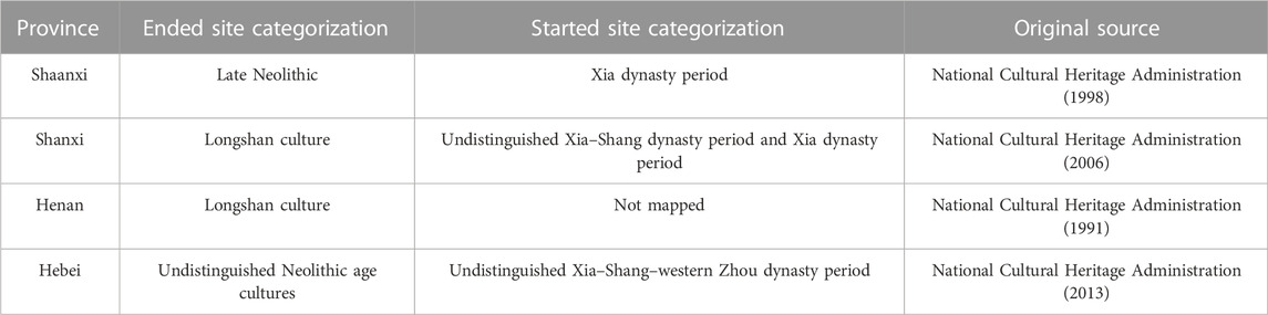
TABLE 1. Categorization of the ended and started sites in the four major provinces of northern China during the study period (by Hosner et al., 2016).
Even so, with the huge number and detailed information of archaeological sites in mainland China, Hosner et al. (2016)’s dataset offers a great opportunity for statistical and spatial analysis. Moreover, it is the most complete collection of the sites so far, all of which were the results of detailed and long-time investigations by the local archaeological authorities. Although no precise date of 14C or other dating technology in each site was given, the dates of the started and ended times of the four cultural types involved in this study have been identified by a large amount of archaeological surveys with modern dating technology. Also, the locations of these sites are accurate to three decimal places. In summary, although the temporal resolution of this dataset is at a centennial scale of these dates, the correct cultural type with generally agreed start and end times and accurate location of each site provides reliable information for this study.
2.3 Methods
2.3.1 One-way analysis of variance
The differences in the coordinates of archaeological sites between the ended and started ages can be compared by one-way ANOVA, which evaluates the equality of two or more group means via the variances (De Vaus, 2002). The null hypothesis states that the means of different groups are equal, and the alternative hypothesis states that at least one of the group means is different from the others (Lee, 2008). It has been widely used in previous studies to determine the significant differences of population dynamics, frequencies of Malthusian population checks (Lee and Zhang, 2010; Lee and Zhang, 2013; Lee et al., 2016), and battle coordinates with a few categories of war defined (Zhang S et al., 2021) between warm and cold periods. In this study, the cultural end or start rather than the climatic phase was chosen as the independent ANOVA factor, while the coordinates of archaeological sites were input as the dependent ANOVA factor. In addition, data dispersion could be measured by the value of variance, and the larger the variance, the more dispersed (i.e., decentralized) the sites.
2.3.2 Standard deviational ellipse and its parameters
The comparison of the mean coordinates between ended and started sites by one-way ANOVA is insufficient, as it cannot elaborate the spatial patterns of archaeological sites during the 4.2 ka BP event. The site distributions and from which whether any regular pattern is unveiled can be solved by the tool, the SDE in ArcGIS. Put forward by Lefever (1926), it is a common method used to measure the trend for a set of points and to separately calculate the standard distance along the x- and y-directions, and it is taken as a proxy of the main range of culture in this study. The ellipse is referred to as the SDE because the standard deviation (1σ by default) of the x- and y-coordinates from the mean center is calculated to define the axes of the ellipse. The information on central tendency, dispersion of sites, and whether the site distributions are elongated with a specific direction can be obtained from the output. Furthermore, when an ellipse is calculated, a few elliptical parameters are generated as well, and their definitions are outlined as follows.
2.3.2.1 Area
The elliptical area (s), showing the major coverage of sites, is calculated via the following equation:
where a and b denote the length of the semi-major and semi-minor axis, respectively. The unit of s is 104 km2.
2.3.2.2 Eccentricity
Eccentricity (e) determines whether an ellipse is oblate or close to a circle. It ranges between 0 and 1 (dimensionless), and the smaller the rounder, the larger the flatter. The formula of e is given as follows:
where c is the semi-focal distance and can be obtained from the formula:
Compared with a geographic coordinate system, in which the spatial unit is expressed as degree or degree–minute–second, a projected coordinate system is required for the SDE so that the parameters can be accurately calculated. a and b (in kilometer) are automatically generated with an attribute table in ArcGIS, and they can be substituted into the aforementioned formulas to obtain e. The three parameters, a, s, and e were combined to measure the cultural decentralization in this study. The longer the semi-major axis (a), the larger the elliptical area (s), and the larger the eccentricity (e), the more decentralized the archaeological sites.
2.3.3 Frequency histogram
Except the one-way ANOVA and SDE, frequency histogram was also applied to show the frequency distributions of site coordinates and central tendency. The longitude and latitude were divided by one-degree intervals. The more concentrated the sites, the higher the frequencies with fewer intervals, and the larger the differences between them and other frequencies of intervals. If the sites have more decentralized distributions, such differences are smaller, while two or more peaks of frequencies may exist.
3 Results
Before visualizing the spatial patterns of archaeological sites in two ends of northern China during 4200–3900 BP, the time-series of climate change and the started/ended site number are presented and compared in Figure 1. It clearly exhibits the climate cooling in the 4.2 ka BP event (Figure 1A), which symbolizes the termination of the Holocene Optimum/Megathermal Period and the transition of the mid–late Holocene (Walker et al., 2018). Looking from the long-term (300-yr-filtered thick line) trends, the precipitation anomaly by tree-ring δ18O (Yang et al., 2021) reaches the minimum at circa 3950 BP (Figure 1B), while the troughs of the model-derived precipitation anomaly (Li et al., 2022; Figure 1C) and the temperature anomaly are consistent during 4100–4000 BP. Correspondingly, in Figure 1D, large numbers of archaeological sites (2,445) ended in this period, while 2,109 new sites emerged. Specifically, the numbers increase from 1,036 for the Majiayao culture to 1,795 for the Qijia culture, which almost doubles; by contrast, the numbers drastically decrease from the Longshan culture (1,409) to the Yueshi culture (314) by nearly 80%. Since the total number of the started sites only reduced by about 14% compared with that of the ended sites, the abandonment of human settlements possibly caused by climatic exacerbation and concurrent environmental degradation in northern China throughout the 4.2 ka BP event was by no means equal to societal “collapse” yet transition instead (e.g., people just out-migrated to better living conditions for survival and/or gradually adapted).
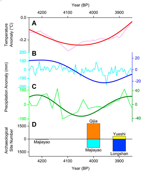
FIGURE 1. Time-series of climate change and the number of archaeological sites in northern China during 4200–3900 BP. Note: (A) temperature anomaly (red) reconstructed by Pei et al. (2019); (B) precipitation anomaly (blue) calculated by Yang et al. (2021); (C) precipitation anomaly (green) simulated by Li et al. (2022); these data were detrended (thin line with light color) and smoothed by a 300-year Butterworth low-pass filter (thick line with deep color); and (D) archaeological site numbers (started site—the Qijia culture: orange; the Yueshi culture: yellow; ended sites—the Majiayao culture: cyan; the Longshan culture: blue) from Hosner et al. (2016).
In this study, two pairs of successive regional cultures were compared as cases, and spatial analyses were carried out to investigate any possible pattern that could be related to cultural decentralization during the 4.2 ka BP event. As shown in Figure 2, the distributions of archaeological sites for different cultures are presented and overlaid with river channels. In Shandong, compared with the extensive concentration of the sites of the Longshan culture that drastically declined during the study period (Figure 2A), the sites of the Yueshi culture with decreased number become relatively sparse (Figure 2B). In Gansu and Qinghai, as the started Qijia culture preserved some features from the previous Majiayao culture, they were compared as another case (Figure 2A). The region where the Qijia sites occupy is obviously “wider” than that for the Majiayao culture with respect to the range of longitude (Figure 2B).
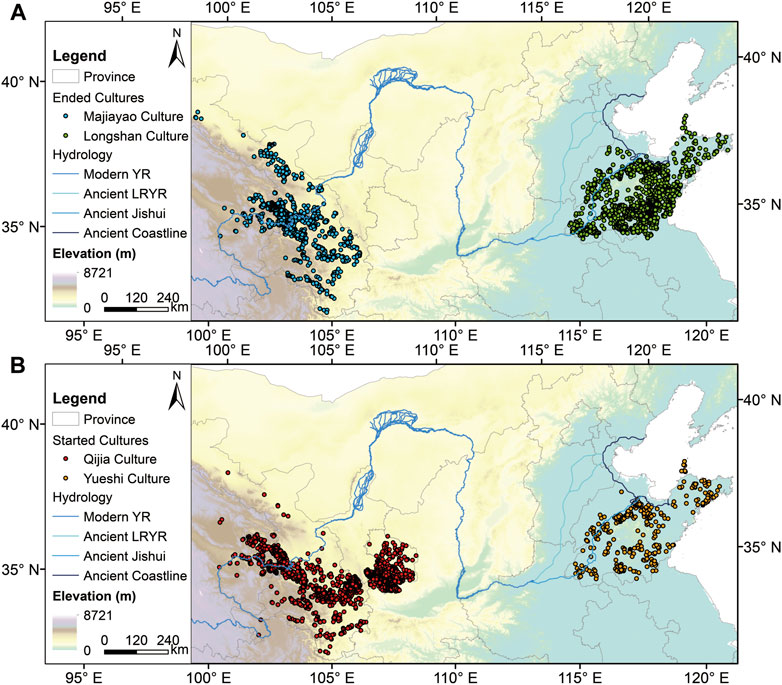
FIGURE 2. Distributions of archaeological sites between different cultures during 4200–3900 BP. Note: (A) ended cultures, including the Majiayao culture (blue) and the Longshan culture (green); (B) started cultures, including the Qijia culture (red) and the Yueshi culture (orange). The courses of the modern Yellow River (YR), the ancient lower reaches of the Yellow River (LRYR) plus the ancient Jishui River, and the ancient coastline of the North China Plain were depicted from Tan (1982) as references.
The regional site distributions were further examined by dividing the site coordinates into longitude and latitude with frequency histograms (Figure 3), in which two key findings could be noted. First, the cultural decentralization mainly embodies a longitudinal extension, i.e., the longitudinal range of the high-frequency interval of the started culture becomes wider. As shown in Figure 3A (left panel), the sites of the ended Majiayao culture chiefly range between 102°E and 104°E, whereas those of the started Qijia culture are concentrated in 102–108°E, with the frequency in 102–103°E being the most prominent. Similarly, as shown in Figure 3B (left panel), the sites of the ended Longshan culture dominantly cluster in 118–119°E solely, yet the counterparts of the started Yueshi culture fall into 117–119°E with 116–117°E to a lesser extent. Second, the latitudinal distribution of sites during the cultural transition manifests a shifted trend. Among these cultures, the sites of the Majiayao culture (Figure 3A, right panel) stand out from the interval of 36–37°N, with 35–36°N taken as the second place, while the counterparts of the Qijia culture largely cluster in 35–36°N. For the Longshan culture (Figure 3B, right panel), the frequency values of latitude between 35°N and 37°N are close and the value in the interval of 35–36°N is the largest, yet 36–37°N is the major interval of latitudinal distribution for the Yueshi sites. This finding indicates that compared with the previous cultures, the Qijia culture in the west and the Yueshi culture in the east generally shifted toward lower and higher latitude by one degree, respectively. The reason why the moving directions are different will be given in the following section.
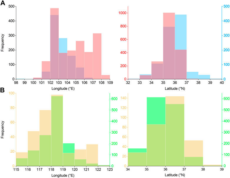
FIGURE 3. Frequency histograms showing the coordinates between the ended and started cultures. Note: (A) the Majiayao culture (blue) vs. the Qijia culture (red); (B) the Longshan culture (green) vs. the Yueshi culture (earthy yellow). The color of the y-axis follows the cultural type.
The differences in coordinates between different ended and started cultures reflected by one-way ANOVA are shown in Table 2. Except the longitude between the Longshan culture and the Yueshi culture (Panel B), which fails to pass the significance test (p = 0.892), others are significant at the 0.001 level. Regarding the mean longitudes for the ended cultures (the Majiayao culture and the Longshan culture), they are situated slightly more westward than the ones for the started cultures (the Qijia culture and the Yueshi culture), but there is no consistency for the latitudinal mean. As for longitude, the variances of the started cultures are larger than those of the ended cultures; moreover, for the same culture, the variances of longitude are always larger than those of latitude. Therefore, the coordinates (especially for longitude) of the started cultures are more decentralized.
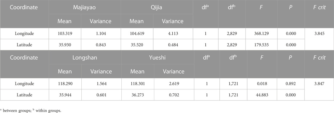
TABLE 2. One-way ANOVA of the coordinates of archaeological sites between different cultures. Panel (A): the Majiayao culture vs. the Qijia culture. Panel (B): the Longshan culture vs. the Yueshi culture.
The directional characteristics of archaeological sites for different cultures are also revealed by the SDEs (Figure 4) and their parameters (Table 3). In Figure 4, evidently, the orientations of the SDEs for the successive ended and started cultures are relatively in agreement. Specifically, the SDE directions for the Majiayao culture (cyan) and the Qijia culture (red) are both northwest–southeast, along the basins/valleys of the Yellow River and its tributaries in Gansu and Qinghai, while the SDEs for the Longshan culture (blue) and the Yueshi culture (orange) elongate northeast–southwestward, which is possibly regulated by the central Shandong Hills where the sites surrounded, and such a direction is also identical to the counterpart of the Shandong Peninsula. Additionally, based on the data in Table 3, the areas, semi-major axes, and shapes of the SDEs for the started cultures are larger, longer, and flatter than their counterparts for the previous ended cultures, respectively. For example, the values of the area, semi-major axis, and eccentricity of the SDE for the Qijia culture are around 7.9 × 10⁴ km2, 258 km, and 0.93, respectively, compared with 4.6 × 10⁴ km2, 173 km, and 0.87 for the Majiayao culture. In short, these SDEs and their parameters indicate that the decentralization trend of the started cultures after 4.2 ka BP is valid on the regional scale.
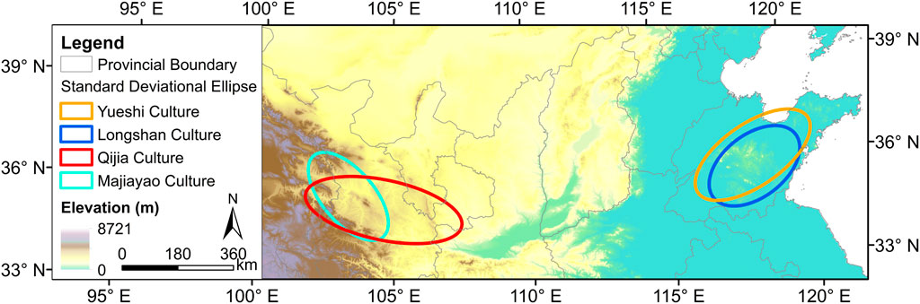
FIGURE 4. Comparison of standard deviational ellipses (SDEs) for the successive ended and started cultures. Note: the Majiayao culture (cyan) vs. the Qijia culture (red); the Longshan culture (blue) vs. the Yueshi culture (orange).
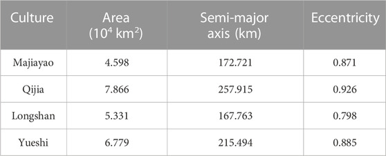
TABLE 3. Parameters of SDEs for archaeological sites of different cultures.
4 Discussion
4.1 Decentralization and adaptation differences of cultural cases in different regions
When ancient people encountered drastic climate change, there were two choices, migration and cultural adaption. Short-term and short-distance migration is preferable since cultural adaptation is usually a considerably long process, in particular technological progress, for example. As there is no instant effect for cultural adaption, people had to abandon their original settlements and out-migrate for more resources under the impacts of cooling and aridification during the 4.2 ka BP event, and thus settlement decentralization became the major trend for survival. In addition, the decentralized spatial patterns of the cross-regional cases reflect the differences in latitudinal variations of sites and the orientations of the SDEs (Figures 3, 4). As shown previously, the north-to-south movement from the Majiayao culture to the Qijia culture and the south-to-north shift from the Longshan culture to the Yueshi culture are possibly pertinent to water intake, as agriculture played an important part in people’s livelihood at that time (Jia et al., 2013; An et al., 2021). Since the climate turned colder and (foremost) drier during the study period (Figure 1), it is understandable that dryland farming systems in northern China were severely hit. Therefore, people had to migrate to the areas closer to rivers or lakes for getting water for irrigation, especially toward the Yellow River with the largest runoff in North and Northwest China. From Table 4, it is apparent that the distances between water bodies and the started sites, including the mean, 90th percentile (i.e., the shorter the distance, the faster the cumulative frequency curve reaches 90%), and maximum ones, are shorter than the counterparts of the ended sites, which means the started cultures became more water-dependent. In the west, the majority of the Qijia sites are still concentrated near the border between Qinghai and Gansu and distributed along the Yellow River and its tributaries, yet the originally marked sites located in the reaches of the Shiyang River (an inland river) of the Hexi Corridor during the Majiayao period were mostly uninhabited. Meanwhile, part of dense sites shifted toward the eastern Gansu/Longdong Plateau (i.e., central Loess Plateau) and distributed along the Jing River, the largest tributary of the Wei River (Supplementary Figure S1). Such a spatial disparity may imply the aridification of Northwest China around 4000 BP (An et al., 2005). With regard to the eastern area, during the Longshan era, many sites were situated in the south of the central Shandong Hills, where the most remarkable ones were distributed along the Yi–Shu rivers (tributaries of the Huai River) and the Mi River (flowing through present-day Weifang city). By contrast, during the Yueshi period, the sites only clustered in the reaches of the Xiaoqing River (located in the north of the Hills, probably the ancient Jishui River according to historical records), yet the high-density sites for the previous Longshan culture disappeared, with scattered sites left, particularly in the southeast of the Hills (Figure 2 and Supplementary Figure S2).
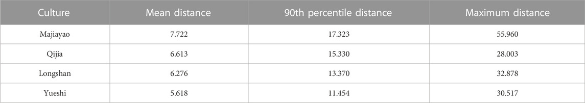
TABLE 4. Statistics of the distance (km) between the archaeological site and the water body (including rivers and lakes) for different cultures. Note: the sites on the islands were excluded.
In fact, as Hosner et al. (2016) also pointed out in their paper, the changes in site numbers of these two cases are rather contrasting. However, whether the new cultures were more advanced or not may not be deduced by the changes in site numbers since bronze artifacts were found in both sites of Yueshi and Qijia cultures (Cohen, 2001; Yang et al., 2017; Zhang et al., 2017). Granted, compared with the Yueshi culture, the Qijia culture developed more rapidly and became more sophisticated. Owing to the trans-Eurasian material exchange during 5000–4000 BP, large number of specimens of crop (wheat and barley) and livestock (cattle, goat, sheep, or horse) were identified in the Qijia sites, while the bronze metallurgy was introduced and the bronze products were excavated during this period (Dong et al., 2017; Yang et al., 2017; Zhang et al., 2017; Dong et al., 2020; Dong et al., 2021; Dong et al., 2022; Ren et al., 2022). Also, the diversified environments benefited from semi-arid temperate continental climate to semi-humid temperate monsoon climate, which were in favor of such an emergence/transition of new culture and the inhabitants for adaptation and survival in the Gansu–Qinghai region. By contrast, the relatively homogeneous environment in the Shandong Peninsula seems the bane of decentralization. As mentioned previously, the northern and western sides belong to the low-lying and flood-prone North China Plain, through which the channel of the Yellow River shifts erratically. Also, the central Shandong Hills are not very high but steep, which may not well-conserve water or control floods. Furthermore, the open topography toward the surroundings makes the security worse, especially when intertribal–chiefdom conflicts became increasingly frequent since the Longshan era (Han, 2020a; Han, 2020b). Consequently, possibly because of the wars against the cultures in the Central Plain or the Xia Dynasty and/or the legendary flood, the site numbers from the Longshan culture to the Yueshi culture dramatically decreased. Researchers even inferred that people who migrated from the northeast conquered the Longshan culture and created the Yueshi culture, which did not originate from the former, or at least the mix in between (Zhang, 1989). Nevertheless, compared with their predecessors, especially their neighbors who primarily depended on rice cultivation in the south and southeast of the Hills, the Yueshi societies, which relied more on drought-resistant millet farming and extensive exploitation of previously uncultivated lands, no doubt displayed stronger resilience against climatic deterioration during the 4.2 ka BP event (An et al., 2021).
In brief, different geographical settings and land carrying capacities between the western and eastern sides of northern China may lay a foundation for different patterns of the cultural transition from the Neolithic Age to the Bronze Age; additionally, equipped with collective wisdom, humans are not just gregarious animals but their adaptability, flexibility, and activeness in response to climate cooling and drying (and related environmental pressure) should not be ignored.
4.2 Cultural transition in prehistoric northern China and its implications on the climate–society nexus
The transition from the middle to late Holocene in China underwent fundamental changes such as political (re-) organization (from chiefdom to kingdom) and social structure (from egalitarian clans to stratified classes). In comparison to the state formation in the Central Plain (more specifically, the core area crosses the borders among western Henan, eastern Shaanxi, and southern Shanxi), and the cultures surrounding this area were deemed declined (Wu and Liu, 2001). Scholars have explained that environment constraint together with population stress, which were superimposed on the abrupt climatic deterioration during 4.5–4.0 ka BP, accounted for such a peripheral cultural decline and the rise of states in the Central Plain (Wu and Liu, 2001; Wu and Ge, 2014). Others blamed such a decline of the Neolithic cultures beyond the Central Plain for frequent tribal conflicts or the legendary great flood (Wei, 2010; Guo et al., 2013; Wu et al., 2016), yet the authenticity of the latter and (if yes) its possibility that covers such a wide range are still questionable (Dong et al., 2018).
The cultural transition reflected from the spatial patterns of archaeological sites (i.e., the indicator of human settlements) in northern China during the 4.2 ka BP event indicates that the started cultures inherited from the ended ones survived and even thrived through decentralization, which implies the possibility of the periodicity of concentration and decentralization, or coexistence similar to spatial heterogeneity (i.e., concentration occurred in some places but decentralization happened somewhere else). Such a possibility has been corroborated by the experts who focus on the cases in ancient Mesopotamia, Europe, and East Africa (Stein and Wattenmaker, 1990; Fernández-Götz, 2018; Fitzsimons, 2022). Among them, the climate–settlement nexus (i.e., decentralization in the cold phase) has been confirmed (Fernández-Götz, 2018), which is consistent with the spatial pattern of the cultural transition in northern China under the 4.2 ka BP climatic shock in our study. Specifically, during this event, the deteriorated climate dramatically reduced the available resources and, hence, weakened the once prosperous Longshan and Majiayao cultures, with human settlements abandoned in a concentrated way. Meanwhile/subsequently, settlement diffusion and/or adaptation had to be adopted for survival, during which new types of cultures (e.g., the Qijia and Yueshi cultures) were born and the cultural transition was completed accordingly. On one hand, they all decentralized in space/longitude and survived under the extreme climate change and environmental pressure throughout this event. On the other hand, with different response modes, the Qijia culture thrived on the western and central Loess Plateau, while the Yueshi culture in Shandong, though with a simpler pattern, had its own characteristics. It seems different adaptation strategies to climatic and environmental degradation determined different dynamics, mechanisms, processes, and features of the cultural transition in prehistoric China, thus emphasizing the importance of human resilience in the narrative of archaeological studies. By introducing exogenous material “packages”, the more successful case of the Qijia culture undoubtedly implies the benefit of cultural diversity, which is similar to biodiversity (Burke et al., 2021). Such diversity nonetheless deserves further investigations with more cases and evidence in the near future.
5 Conclusion
In this study, with two pairs of successive (i.e., ended and then started) cultural types compared as cases, the phenomenon of decentralization for the “inherited” sites in two ends of northern China during the 4.2 ka BP event (4200–3900 BP) has been unveiled. The consistent spatial patterns of the started cultures support the validity of such decentralization on the regional scale, in which the longitudinal expansion of the sites becomes most striking. Moreover, the different directions of latitudinal movements of the sites between the Majiayao culture and the Qijia culture (from north-to-south) and the Longshan culture and the Yueshi culture (from south-to-north) are observed, which are explained by a shortened distance between the human settlement and the water body for adapting to the prolonged drought. Combined with our findings and those of the previous research on different adaptation strategies adopted by the inherited Qijia and Yueshi cultures, we conclude that prehistoric societies who suffered from climate disasters in northern China during this event had to adapt and even out-migrate for survival through different solutions, which depended upon different geographical settings and land carrying capacities, hence realizing the essential cultural diversity over the mid–late Holocene transition. As cultural diversity is the source of climate adaptation–mitigation strategies and human resilience (Burke et al., 2021), our work may potentially offer new insights into the research on the climate–society nexus and provide some implications for policymakers in response to the impending threat on social and cultural sustainability brought on by contemporary climate change.
Data availability statement
Publicly available datasets were analyzed in this study. These data can be found here: Hosner, D et al. (2016); PANGAEA, https://doi.org/10.1594/PANGAEA.860072.
Author contributions
DZ contributed to the conception and design of the research. SZ and DZ performed the research. SZ analyzed the data. SZ wrote the first draft of the manuscript. Both authors contributed to the revision and approved the submitted version of the manuscript.
Funding
This research was supported by the Second Tibetan Plateau Scientific Expedition and Research Program from the Institute of Tibetan Plateau Research, Chinese Academy of Sciences (2019QZKK0601) and the National Natural Science Foundation of China (41971110).
Acknowledgments
The authors thank the reviewers for their valuable comments on this manuscript.
Conflict of interest
The authors declare that the research was conducted in the absence of any commercial or financial relationships that could be construed as a potential conflict of interest.
Publisher’s note
All claims expressed in this article are solely those of the authors and do not necessarily represent those of their affiliated organizations, or those of the publisher, the editors, and the reviewers. Any product that may be evaluated in this article, or claim that may be made by its manufacturer, is not guaranteed or endorsed by the publisher.
Supplementary material
The Supplementary Material for this article can be found online at: https://www.frontiersin.org/articles/10.3389/feart.2023.1135395/full#supplementary-material
References
An, C., Tang, L., Barton, L., and Chen, F. H. (2005). Climate change and cultural response around 4000 cal yr BP in the Western part of Chinese Loess Plateau. Quat. Res. 63 (3), 347–352. doi:10.1016/j.yqres.2005.02.004
An, J., Kirleis, W., and Jin, G. (2021). Understanding the collapse of the Longshan culture (4400-3800 BP) and the 4.2 ka event in the Haidai Region of China - from an agricultural perspective. Environ. Archaeol. doi:10.1080/14614103.2021.2003583
Burke, A., Peros, M. C., Wren, C. D., Pausata, F. S. R., Riel-Salvatore, J., Moine, O., et al. (2021). The archaeology of climate change: The case for cultural diversity. Proc. Natl. Acad. Sci. U. S. A. 118 (30), e2108537118. doi:10.1073/pnas.2108537118
Butzer, K. W. (2012). Collapse, environment, and society. Proc. Natl. Acad. Sci. U. S. A. 109 (10), 3632–3639. doi:10.1073/pnas.1114845109
Butzer, K. W., and Endfield, G. H. (2012). Critical perspectives on historical collapse. Proc. Natl. Acad. Sci. U. S. A. 109 (10), 3628–3631. doi:10.1073/pnas.1114772109
Chen, W., and Wang, W. (2012). Middle-Late Holocene vegetation history and environment changes revealed by pollen analysis of a core at Qingdao of Shandong province, East China. Quat. Int. 254, 68–72. doi:10.1016/j.quaint.2011.04.005
Cohen, D. J. (2001). The Yueshi culture, the Dong Yi, and the archaeology of ethnicity in early bronze age China. Cambridge: Harvard University.
Correia, D. (2013). F**k jared diamond. Capital. Nat. Social. 24 (4), 1–6. doi:10.1080/10455752.2013.846490
Dong, G., Jia, X., An, C., Chen, F., Zhao, Y., Tao, S., et al. (2012). Mid-Holocene climate change and its effect on prehistoric cultural evolution in eastern Qinghai province, China. Quat. Res. 77 (1), 23–30. doi:10.1016/j.yqres.2011.10.004
Dong, G., Wang, L., Cui, Y., Elston, R., and Chen, F. (2013). The spatiotemporal pattern of the Majiayao cultural evolution and its relation to climate change and variety of subsistence strategy during late Neolithic period in Gansu and Qinghai provinces, Northwest China. Quat. Int. 316, 155–161. doi:10.1016/j.quaint.2013.07.038
Dong, G., Yang, Y., Han, J., Wang, H., and Chen, F. (2017). Exploring the history of cultural exchange in prehistoric Eurasia from the perspectives of crop diffusion and consumption. Sci. China Earth Sci. 60 (6), 1110–1123. doi:10.1007/s11430-016-9037-x
Dong, G., Zhang, F., Liu, F., Zhang, D., Zhou, A., Yang, Y., et al. (2018). Multiple evidences indicate no relationship between prehistoric disasters in Lajia site and outburst flood in upper Yellow River valley, China. Sci. China Earth Sci. 61 (4), 441–449. doi:10.1007/s11430-017-9079-3
Dong, G., Li, R., Lu, M., Zhang, D., and James, N. (2020). Evolution of human–environmental interactions in China from the late paleolithic to the bronze age. Prog. Phys. Geogr. 44 (2), 233–250. doi:10.1177/0309133319876802
Dong, G., Du, L., and Wei, W. (2021). The impact of early trans-Eurasian exchange on animal utilization in northern China during 5000–2500 BP. Holocene 31 (2), 294–301. doi:10.1177/0959683620941169
Dong, G., Du, L., Yang, L., Lu, M., Qiu, M., Li, H., et al. (2022). Dispersal of crop-livestock and geographical-temporal variation of subsistence along the Steppe and Silk Roads across Eurasia in prehistory. Sci. China Earth Sci. 65, 1187–1210. doi:10.1007/s11430-021-9929-x
Drennan, R. D., and Peterson, C. E. (2008). “Centralized communities, population, and social complexity after sedentarization,” in The neolithic demographic transition and its consequences. Editors J. -P. Bocquet-Appel, and O. Bar-Yosef (Dordrecht: Springer), 359–386.
Fernández-Götz, M. (2018). Urbanization in iron age Europe: Trajectories, patterns, and social dynamics. J. Archaeol. Res. 26 (2), 117–162. doi:10.1007/s10814-017-9107-1
Fitzsimons, W. (2022). “Social responses to climate change in a politically decentralized context: A case study from east african history,” in Perspectives on public policy in societal-environmental crises. Editors A. Izdebski, J. Haldon, and P. Filipkowski (Cham: Springer), 145–159.
Gao, C., Wang, X., Jiang, T., and Jin, G. (2009). Spatial distribution of archaeological sites in lakeshore of Chaohu Lake in China based on GIS. Chin. Geogr. Sci. 19 (4), 333–340. doi:10.1007/s11769-009-0333-4
Gledhill, J., Bender, B., and Larsen, M. T. (1995). State and society: The emergence and development of social hierarchy and political centralization (vol. 4). East Sussex: Psychology Press.
Guo, Y., Mo, D., Mao, L., Wang, S., and Li, S. (2013). Settlement distribution and its relationship with environmental changes from the Neolithic to Shang-Zhou dynasties in northern Shandong, China. J. Geogr. Sci. 23 (4), 679–694. doi:10.1007/s11442-013-1037-3
Haldon, J., Chase, A. F., Eastwood, W., Medina-Elizalde, M., Izdebski, A., Ludlow, F., et al. (2020). Demystifying collapse: Climate, environment, and social agency in pre-modern societies. Millennium 17 (1), 1–33. doi:10.1515/mill-2020-0002
Han, D., Ding, M., Peng, S., Zhu, L., Zhao, Q., Jin, H., et al. (2021). Holocene climate evolution and Neolithic cultural evolution recorded in the loess profile in central Shandong province, China. Earth Sci. 10 (6), 315–324. doi:10.11648/j.earth.20211006.17
Han, J. (2020a). Neolithic wars and the course of early Chinese civilization. Soc. Sci. Front. 10, 99–107, 282. (in Chinese with English abstract).
Han, J. (2020b). Violent cultural changes in Longshan period and tribal warfare in Chinese legendary era. J. Soc. Sci. 1, 152–163. (in Chinese with English abstract). doi:10.13644/j.cnki.cn31-1112.2020.01.015
Hosner, D., Wagner, M., Tarasov, P. E., Chen, X., and Leipe, C. (2016). Spatiotemporal distribution patterns of archaeological sites in China during the Neolithic and Bronze Age: An overview. Holocene 26 (10), 1576–1593. doi:10.1177/0959683616641743
Huang, C., Pang, J., Zhou, Q., and Chen, S. (2004). Holocene pedogenic change and the emergence and decline of rain-fed cereal agriculture on the Chinese Loess Plateau. Quat. Sci. Rev. 23 (23), 2525–2535. doi:10.1016/j.quascirev.2004.06.003
Huang, X., Xiang, L., Lei, G., Sun, M., Qiu, M., Storozum, M., et al. (2021). Sedimentary Pediastrum record of middle-late Holocene temperature change and its impacts on early human culture in the desert-oasis area of northwestern China. Quat. Sci. Rev. 265, 107054. doi:10.1016/j.quascirev.2021.107054
Jia, X., Dong, G., Li, H., Brunson, K., Chen, F., Ma, M., et al. (2013). The development of agriculture and its impact on cultural expansion during the late Neolithic in the Western Loess Plateau, China. Holocene 23 (1), 85–92. doi:10.1177/0959683612450203
Lee, H. F. (2008). Climate change and Chinese population growth dynamics over the last millennium. [dissertation]. Hong Kong (China): The University of Hong Kong.
Lee, H. F., and Zhang, D. D. (2010). Changes in climate and secular population cycles in China, 1000 CE to 1911. Clim. Res. 42 (3), 235–246. doi:10.3354/cr00913
Lee, H. F., and Zhang, D. D. (2013). A tale of two population crises in recent Chinese history. Clim. Change 116 (2), 285–308. doi:10.1007/s10584-012-0490-9
Lee, H. F., Zhang, D. D., Pei, Q., Jia, X., and Yue, R. P. (2016). Demographic impact of climate change on northwestern China in the late imperial era. Quat. Int. 425, 237–247. doi:10.1016/j.quaint.2016.06.029
Lefever, D. W. (1926). Measuring geographic concentration by means of the standard deviational ellipse. Am. J. Sociol. 32 (1), 88–94. doi:10.1086/214027
Li, Y., Lu, P., Mao, L., Chen, P., Yan, L., and Guo, L. (2021). Mapping spatiotemporal variations of Neolithic and Bronze Age settlements in the Gansu-Qinghai region, China: Scale grade, chronological development, and social organization. J. Archaeol. Sci. 129, 105357. doi:10.1016/j.jas.2021.105357
Li, X., Liu, X., Pan, Z., Xie, X., Shi, Z., Wang, Z., et al. (2022). Orbital-scale dynamic vegetation feedback caused the Holocene precipitation decline in northern China. Commun. Earth Environ. 3 (1), 257. doi:10.1038/s43247-022-00596-2
Liu, L. (1996). Settlement patterns, chiefdom variability, and the development of early states in North China. J. Anthropol. Archaeol. 15 (3), 237–288. doi:10.1006/jaar.1996.0010
National Cultural Heritage Administration (1991). Atlas of Chinese cultural Relics: Henan volume. Beijing: Sinomaps Press. (in Chinese).
National Cultural Heritage Administration (1998). Atlas of Chinese cultural Relics: Shaanxi volume. Xi’an: Xi’an Cartographic Publishing House. (in Chinese).
National Cultural Heritage Administration (2006). Atlas of Chinese cultural Relics: Shanxi volume. Beijing: Sinomaps Press. (in Chinese).
National Cultural Heritage Administration (2013). Atlas of Chinese cultural Relics: Hebei volume. Beijing: Sinomaps Press. (in Chinese).
Pei, Q., Zhang, D. D., Li, J., and Fei, J. (2019). Proxy-based temperature reconstruction in China for the Holocene. Quat. Int. 521, 168–174. doi:10.1016/j.quaint.2019.06.032
Rajala, U. (2013). The concentration and centralization of late prehistoric settlement in central Italy: The evidence from the nepi survey. Pap. Br. Sch. Rome 81, 1–38. doi:10.1017/s0068246213000032
Ren, L., Yang, Y., Qiu, M., Brunson, K., Chen, G., and Dong, G. (2022). Direct dating of the earliest domesticated cattle and caprines in northwestern China reveals the history of pastoralism in the Gansu-Qinghai region. J. Archaeol. Sci. 144, 105627. doi:10.1016/j.jas.2022.105627
Shi, Z., Chen, T., Storozum, M. J., and Liu, F. (2019). Environmental and social factors influencing the spatiotemporal variation of archaeological sites during the historical period in the Heihe River basin, Northwest China. Quat. Int. 507, 34–42. doi:10.1016/j.quaint.2018.12.016
Stein, G. J., and Wattenmaker, P. (1990). “Settlement trends and the emergence of social complexity in the Leilan Region of the Habur Plains (Syria) from the fourth to the third millennium B.C,” in The origins of North mesopotamian civilization: Ninevite 5 chronology, economy, society. Editor H. Weiss (New Haven, CT: Yale University Press), 361–386.
Wagner, M., Tarasov, P., Hosner, D., Fleck, A., Ehrich, R., Chen, X., et al. (2013). Mapping of the spatial and temporal distribution of archaeological sites of northern China during the Neolithic and Bronze Age. Quat. Int. 290–291, 344–357. doi:10.1016/j.quaint.2012.06.039
Walker, M., Head, M. J., Berkelhammer, M., Björck, S., Cheng, H., Cwynar, L., et al. (2018). Formal ratification of the subdivision of the Holocene series/epoch (quaternary system/period): Two new global boundary stratotype sections and points (GSSPs) and three new stages/subseries. Episodes J. Int. Geosci. 41 (4), 213–223. doi:10.18814/epiiugs/2018/018016
Wang, X., and Wang, L. (2022). Holocene environmental evolution and human adaptability in a coastal area: A case study of the jiaodong Peninsula in Shandong province, eastern China. Anthropol. Sci. 220528, 45–53. doi:10.1537/ase.220528
Wang, K., Yu, X., Xia, J., Xu, S., Zhang, T., Xu, Y., et al. (2022). Holocene environmental evolution history based on sporopollenin and micropaleontological reconstruction of KY-01 in the Yellow River Delta. J. Water Clim. Chang. 13 (1), 206–223. doi:10.2166/wcc.2021.144
Wang, Y., Wang, N., Zhao, X., Liang, X., Liu, J., Yang, P., et al. (2022). Field model-based cultural diffusion patterns and GIS spatial analysis study on the spatial diffusion patterns of Qijia culture in China. Remote Sens. 14 (6), 1422. doi:10.3390/rs14061422
Wei, X. (2010). Discussion of the age of Longshan city sites in the Central Plain and the reason of their rise and abandonment. Huaxia Archaeol. 1, 49–60. (in Chinese). doi:10.16143/j.cnki.1001-9928.2010.01.004
Wen, X., Bai, S., Zeng, N., Chamberlain, C. P., Wang, C., Huang, C., et al. (2013). Interruptions of the ancient shu civilization: Triggered by climate change or natural disaster? Int. J. Earth Sci. 102 (3), 933–947. doi:10.1007/s00531-012-0825-9
Wu, Q., Zhao, Z., Liu, L., Granger, D. E., Wang, H., Cohen, D. J., et al. (2016). Outburst flood at 1920 BCE supports historicity of China’s Great Flood and the Xia dynasty. Science 353 (6299), 579–582. doi:10.1126/science.aaf0842
Wu, W., and Ge, Q. (2014). 4.5-4.0kaB.P. Climate change, population growth, circumscription and the emergence of chiefdom-like societies in the middle-lower Yellow River valley. Quat. Sci. 34 (1), 253–265. (in Chinese with English abstract). doi:10.3969/j.issn.1001-7410.2014.01.29
Wu, W., and Liu, T. (2001). 4000a B.P. event and its implications for the origin of ancient Chinese civilization. Quat. Sci. 21 (5), 443–451. (in Chinese with English abstract).
Xiao, J., Zhang, S., Fan, J., Wen, R., Xu, Q., Inouchi, Y., et al. (2019). The 4.2 ka event and its resulting cultural interruption in the Daihai Lake basin at the East Asian summer monsoon margin. Quat. Int. 527, 87–93. doi:10.1016/j.quaint.2018.06.025
Yan, L., Yang, R., Lu, P., Teng, F., Wang, X., Zhang, L., et al. (2021). The spatiotemporal evolution of ancient cities from the late Yangshao to Xia and Shang dynasties in the central plains, China. Herit. Sci. 9 (1), 124. doi:10.1186/s40494-021-00580-7
Yang, Y., Dong, G., Zhang, S., Cui, Y., Li, H., Chen, G., et al. (2017). Copper content in anthropogenic sediments as a tracer for detecting smelting activities and its impact on environment during prehistoric period in Hexi Corridor, Northwest China. Holocene 27 (2), 282–291. doi:10.1177/0959683616658531
Yang, B., Qin, C., Bräuning, A., Osborn, T. J., Trouet, V., Ljungqvist, F. C., et al. (2021). Long-term decrease in Asian monsoon rainfall and abrupt climate change events over the past 6,700 years. Proc. Natl. Acad. Sci. U. S. A. 118 (30), e2102007118. doi:10.1073/pnas.2102007118
Zhang, G. (1989). A preliminary study on the origin of the Yueshi culture. J. Zhengzhou Univ. Philos. Soc. Sci. Ed.) 1, 5–10. (in Chinese).
Zhang, S., Yang, Y., Storozum, M. J., Li, H., Cui, Y., and Dong, G. (2017). Copper smelting and sediment pollution in bronze age China: A case study in the Hexi corridor, northwest China. Catena 156, 92–101. doi:10.1016/j.catena.2017.04.001
Zhang, H., Cheng, H., Sinha, A., Spötl, C., Cai, Y., Liu, B., et al. (2021). Collapse of the Liangzhu and other Neolithic cultures in the lower Yangtze region in response to climate change. Sci. Adv. 7 (48), eabi9275. doi:10.1126/sciadv.abi9275
Keywords: (de-) centralization, spatial pattern, archaeological site, northern China, 4.2 ka BP event
Citation: Zhang S and Zhang DD (2023) Centralization or decentralization? A spatial analysis of archaeological sites in northern China during the 4.2 ka BP event. Front. Earth Sci. 11:1135395. doi: 10.3389/feart.2023.1135395
Received: 31 December 2022; Accepted: 01 March 2023;
Published: 17 March 2023.
Edited by:
Ren Lele, Lanzhou University, ChinaReviewed by:
Jie Fei, Fudan University, ChinaHaipeng Wang, Northwest Institute of Eco-Environment and Resources (CAS), China
Copyright © 2023 Zhang and Zhang. This is an open-access article distributed under the terms of the Creative Commons Attribution License (CC BY). The use, distribution or reproduction in other forums is permitted, provided the original author(s) and the copyright owner(s) are credited and that the original publication in this journal is cited, in accordance with accepted academic practice. No use, distribution or reproduction is permitted which does not comply with these terms.
*Correspondence: David D. Zhang, ZHpoYW5nQGd6aHUuZWR1LmNu